Challenges
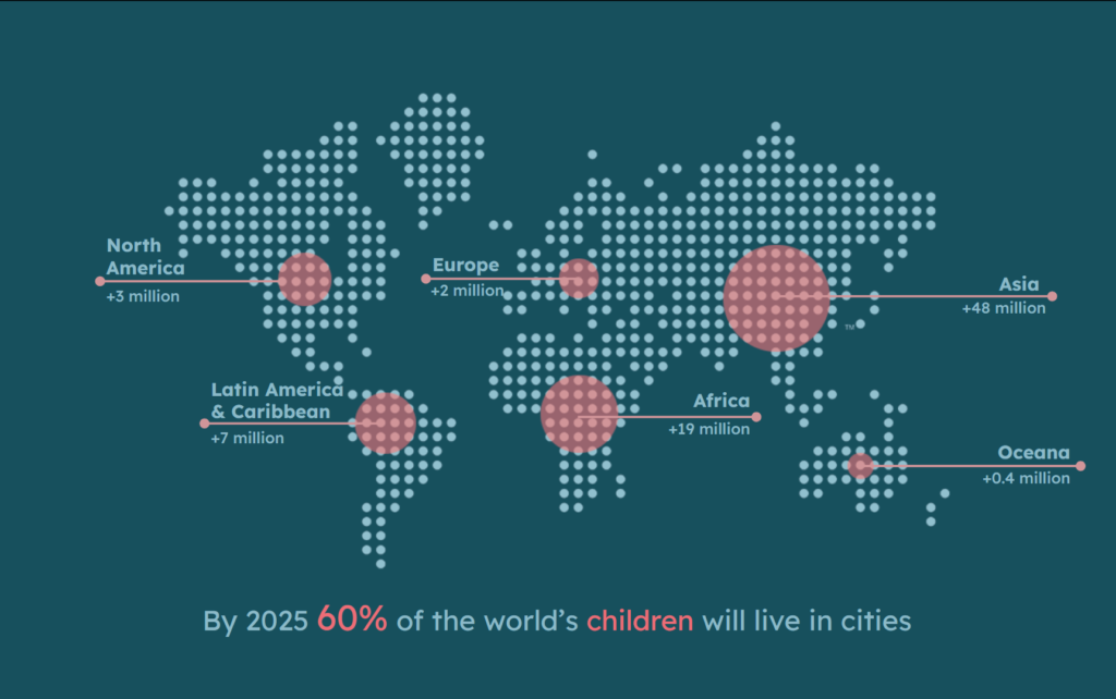
The projection by UNICEF indicating that 60% of the global child population will reside in urban areas by 2025 demands a critical reevaluation of our cities’ readiness for such a transformation. This shift presents unprecedented challenges and opportunities.
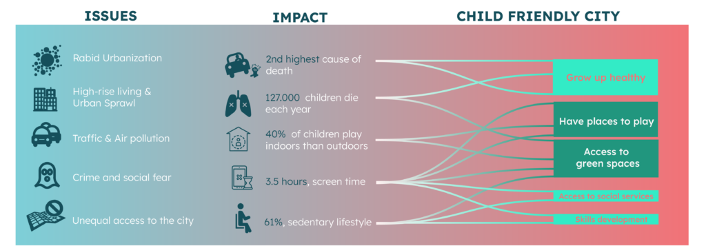
By examining the fundamental challenges faced by urban childhood today, it becomes evident that the significant traffic congestion and air pollution in cities contribute to a high number of child fatalities annually. Additionally, social fears and limited access to urban spaces confine children indoors, leading to an escalating reliance on screens and a sedentary way of life.
According to UNICEF, a child-friendly city is one where children can grow up in a healthy environment, exercise their rights, develop their skills, and have access to social services, as well as green spaces and play areas. For The two last facts, there is a potential to be implemented through design.
The 2-Dimensions of child-friendly urban planning
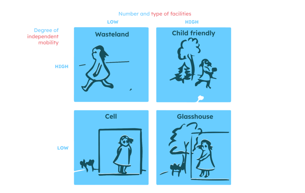
Furthermore, child-friendly urban planning, as proposed by researcher Marketta Kytta, involves a two-dimensional framework that assesses the correlation between children’s independent mobility and the availability of amenities in their surroundings. Depending on this correlation, a place can be categorized as wasteland, where children have the freedom to move but limited opportunities for activities; cell, where both independent mobility and the availability of amenities are low; glasshouse, where there is a high diversity of amenities but limited independent mobility; and child-friendly, where both independent mobility and the availability of amenities are at a high level.
Focus Group
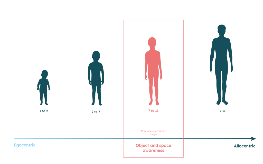
The primary focus of this project centers on children in the middle childhood phase, encompassing ages 7 to 11 years old. This developmental stage is called the “concrete operational stage” in cognitive development, characterized by the transition from reliance on imagination to logical thinking, leading to enhanced problem-solving abilities. Moreover, this period represents a pivotal phase in developing their spatial skills, as they progress from an egocentric approach, perceiving space solely through their senses, to an allocentric approach, where they navigate space by utilizing external cues and references.
Free time use | impact
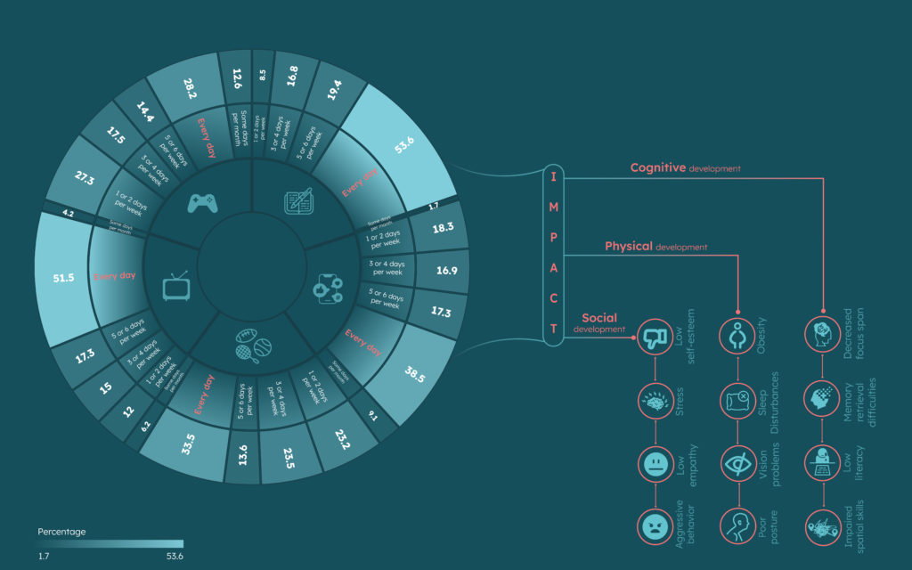
Upon careful examination of the daily routines of children in the Barcelona age group, it is evident that approximately half of them allocate their free time to homework and television viewing. Concurrently, roughly 40 percent of the children are actively engaged in social media, while nearly 30 percent participate in sports and indulge in video gaming.
Regrettably, the excessive utilization of screen time during their leisure hours can exert a substantial negative influence on their physical, cognitive, and social development. This prolonged exposure to screens has been associated with adverse effects, including diminished attention spans, impaired spatial skills, sleep disruption, decreased self-esteem, and heightened tendencies toward aggressive behavior.
Moreover, the mentioned statistics shed light on the presence of the Spanish paradox, as discerned from the findings of the Global Matrix 4 Activity Report. Despite displaying a commendable level of sports participation, children in Spain also exhibit a considerable prevalence of sedentary lifestyles, which warrants concern and further investigation.
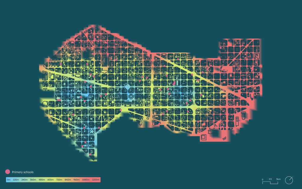
Urban Amenities | Distribution
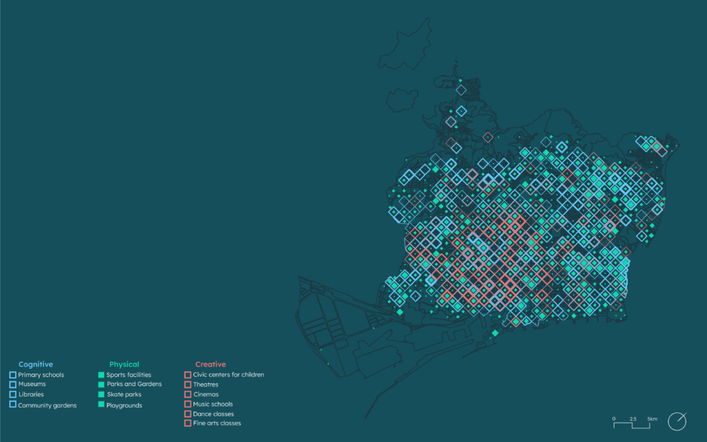
After conducting a comprehensive assessment of the children’s amenities within Barcelona city and categorizing them according to their respective contributions to skill development, a noticeable pattern emerges. It becomes apparent that there is a more extensive distribution of facilities and resources that primarily focus on promoting cognitive and physical development, while comparatively fewer amenities are dedicated to fostering creativity among the children in the city.
The 2-Dimensions of Barcelona city
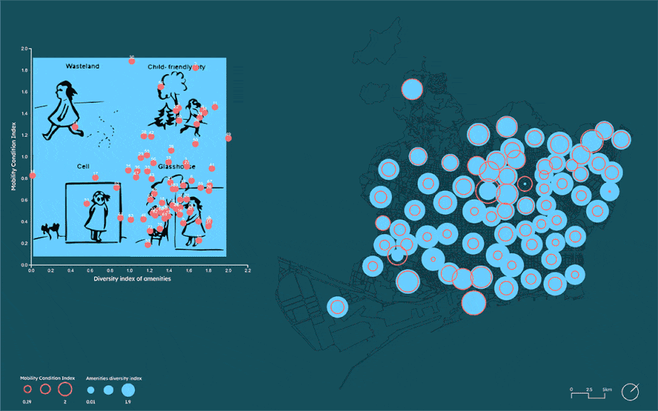
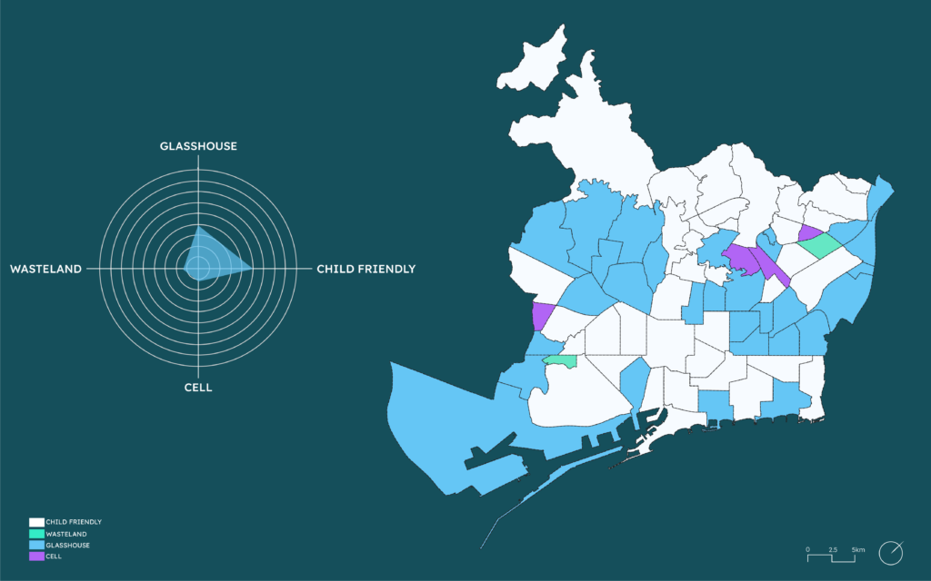
The implementation of child-friendliness in the city involved the consideration of two primary dimensions. The first dimension focused on assessing the diversity of available amenities, while the second dimension involved evaluating the mobility index, which took into account factors such as sidewalk width, traffic volume, and the presence of cars.
Upon analyzing the correlation between these two dimensions, the following conclusions were drawn: The mainland of the city was identified as a “glasshouse”, indicating a lower level of child-friendliness. However, the suburbs exhibited a more varied pattern, with some areas classified as “cells” (i.e., less child-friendly) and others as “child friendly.” Additionally, both the old town and the port of the city were identified as areas with a higher degree of child-friendliness.
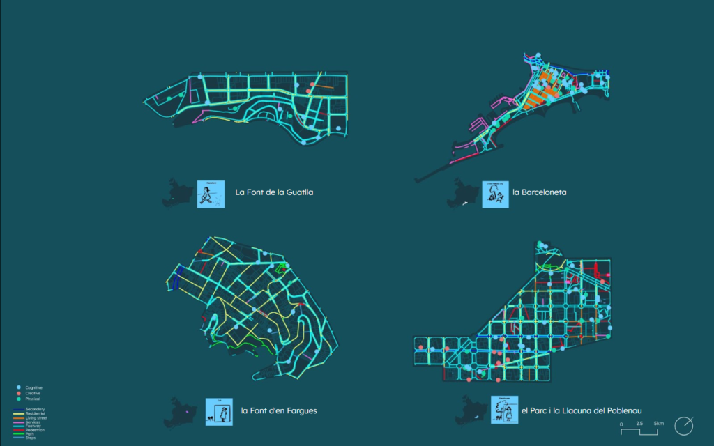
Typological Assessment of Barcelona’s Neighborhoods
In evaluating the various typologies, it becomes evident that La Font de la Guatlla, situated on the outskirts of Barcelona, falls under the classification of a wasteland due to its deficiency in diverse amenities despite its residential nature. Conversely, La Font d’en Fargues, another suburban neighborhood, is identified as a cell primarily because its sidewalks measure narrower than 1.8 meters, cars are frequently parked alongside the sidewalks, and the presence of steps indicates steep slopes. Additionally, this area also suffers from a scarcity of diverse amenities, with only one playground and a limited number of schools present. Conversely, El Parc I la Llacuna del Poblenou is categorized as a glasshouse neighborhood, attributed to its wide array of amenities, despite the presence of secondary roads. Lastly, La Barceloneta is considered a child-friendly neighborhood, as a substantial portion of its streets are designed as living streets, offering an extensive range of amenities.
Barcelona’s Urban Transformation: Superblocks Paving the Way Towards Child-Friendly Neighborhoods
Barcelona has undertaken a distinctive urban design initiative known as Superblocks, aimed at placing a greater emphasis on pedestrians and sustainability while de-prioritizing cars. The concept involves creating clusters of inner-minor streets, referred to as green streets, which are closed off to through traffic.
Upon conducting a reassessment of the network following this transformative endeavor, it becomes evident that the mainland of Barcelona is poised to be reclassified under the child-friendly typology, as identified within this two-dimensional model. The implementation of Superblocks is expected to foster pedestrian-centric environments and promote a greater sense of safety and accessibility for children, ultimately contributing to more vibrant and family-oriented neighborhoods.
Objectives
The urban transformation undertaken by Barcelona through the implementation of Superblocks has prioritized pedestrian-friendly environments while reducing transportation-related threats. However, the question arises whether a network that has mitigated transport risks automatically qualifies as a child-friendly network.
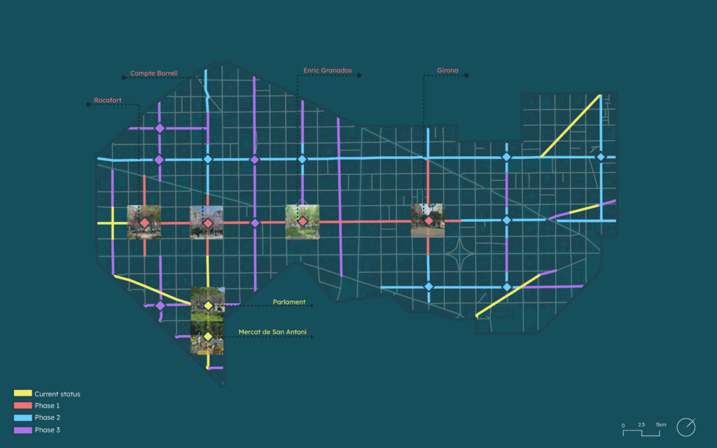
Focus area: Eixample district
My research centers on a particular district, referred to as Example District, which has undergone a significant urban transformation characterized by the conversion of axes into green and pedestrianized spaces. Specifically, my focus is directed toward examining the axes’ conditions in the current situation and during Phase 1 of the ongoing transformation.
Methodology
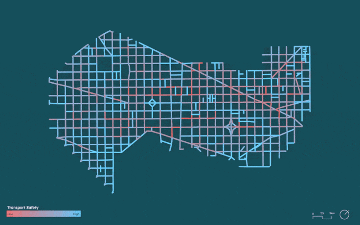
The research focuses on evaluating the network segments in the Eixample district from the perspective of transport and social safety, attractiveness, and comfort. To achieve this, a comprehensive dataset encompassing various aspects of the urban environment has been integrated into the analysis.
By conducting a spatial correlation assessment of the dataset with the network segments, the researcher has assigned weights to each parameter, reflecting their relative importance in determining the ideal paths. The goal is to identify pathways that align with these specified parameters, emphasizing aspects such as safety, attractiveness, and comfort for pedestrians.
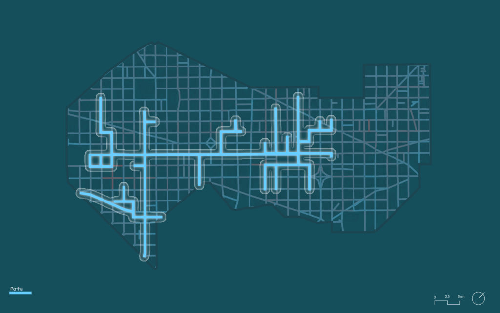
To ensure practicality and convenience, the paths considered for further analysis are filtered based on their length, retaining those that are under 900 meters. This criterion ensures that the paths can be comfortably walked within 15 minutes, taking into account the average attention span of children during middle childhood, which typically ranges from 15 to 30 minutes.

Urban Street Network Analysis
Upon examination of the outcomes derived from the street evaluation, I have acquired a network that exhibits the utmost degree of safety, appeal, and convenience.
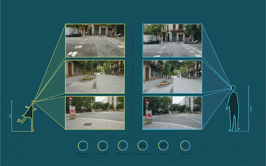
Visual Perception and Pedestrian Routes: A Child’s Perspective
The next challenge is to effectively guide children to navigate these routes safely and enjoyably. To address this, I have adopted an approach that views the paths from the perspective of children. Employing image segmentation techniques, I have identified three critical locations along their navigation. Subsequently, I have quantified the percentage of various elements, including roads, sidewalks, urban furniture, greenery, buildings, and cars, that are visible to children in comparison to what is perceivable from an adult’s perspective.
The findings reveal that ground materials and textures constitute a significant portion of children’s visual experience, while the horizon’s elongation contributes to a sense of expansiveness and potential possibilities during the walking journey.
Fostering Exploration Through Wayfinding
Through the application of wayfinding principles, including limited navigational choices, place identity, and well-structured paths, I have devised a method to sustain children’s motivation during their walking journey.
The result is a physically interactive game, intricately woven with a captivating story, specifically designed to stimulate children’s curiosity and encourage exploration of their surroundings.

The platform: EcoKnights
Expanding on the walking game, a pioneering model of citizen science emerges, wherein children assume a crucial role in the systematic acquisition of data pertinent to climate change challenges. The data amassed through this collection process can be seamlessly uploaded to the Ecoknight platform, which serves as a collaborative nexus dedicated to addressing pressing environmental concerns. Within this platform, the child’s active involvement facilitates the unlocking of eco-friendly solutions. Concurrently, researchers seeking sustainable resolutions gain privileged access to download the meticulously compiled datasets, endowing them with invaluable resources for meticulous scientific inquiry.
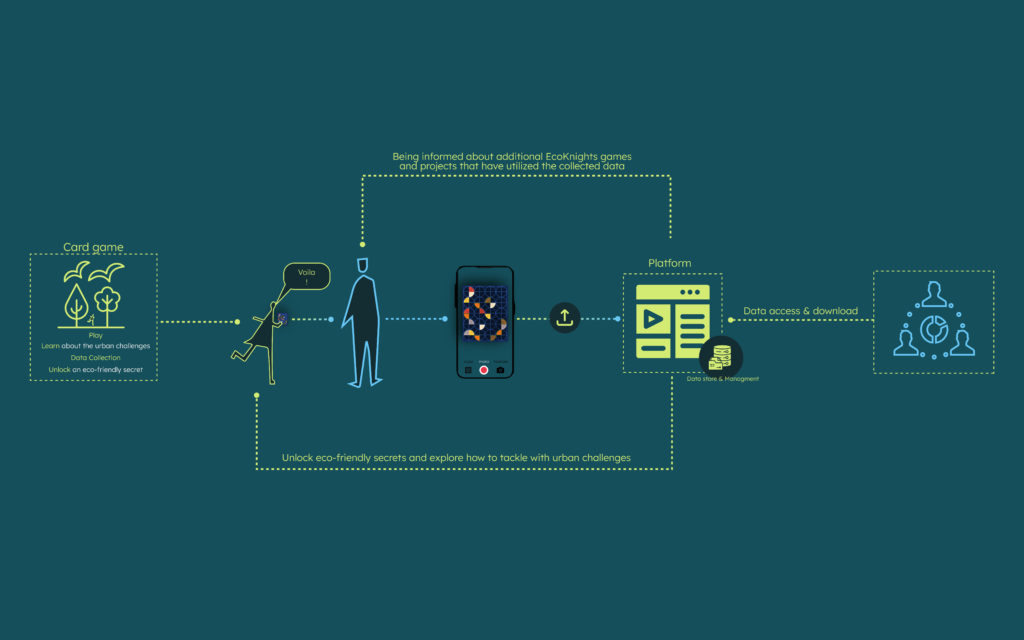
Within the platform, an assortment of games specifically tailored for the purpose of gathering data from young individuals can be discovered. These games encompass a range of activities, such as educational endeavors involving the identification of various species, including bees, birds, and flora.
Upon selection of a game, a concise summary of its objectives and components becomes accessible. Additionally, an informative video designed to educate players about the challenges presented within the game is provided. To illustrate, in the context of a game centered around mitigating food wastage, children are imparted with knowledge concerning its environmental ramifications. Furthermore, feasible actions to curtail their ecological footprint are elucidated, offering insights into practical, everyday practices.
For those who are already engaged as participants within the EcoKnighter community and have successfully concluded a mission, a mechanism is in place to enter a unique code indicated on the game’s packaging. This step is followed by the uploading of pertinent data collection photographs, further enhancing the interactive and participatory nature of the platform.
Engagement in this process extends the opportunity to unveil an eco-friendly enigma, thus delving into the realm of composting and the transformative processes inherent in the manipulation of food materials—a convergence of science and sustainability.
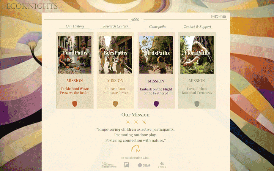
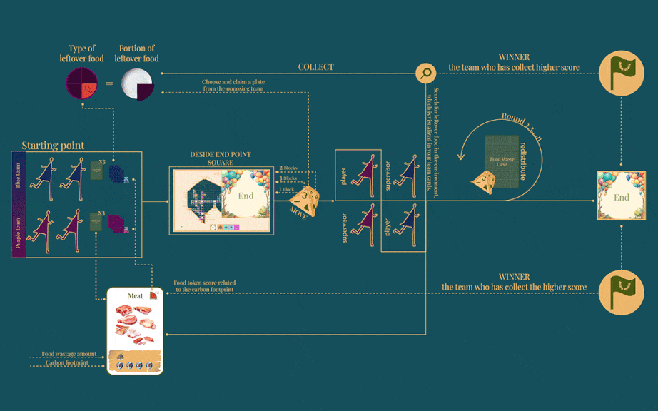
Game example: Foodpaths
The game is an integral component within a series of sequential games that address multifaceted urban challenges. It comprises an ensemble of six distinct cards, each correlating with a specific food category, meticulously outlining their corresponding carbon footprint implications. Accompanying these cards are six data collectors, designed to systematically compile and house datasets. These collectors adopt a triangular wedge configuration, distinguished by a spectrum of colors, signifying the diverse food categories.
Complementing this setup is a cartographic representation denoting the trajectories traversed by the game, thereby illuminating the pathways along which the gameplay unfolds. This visual depiction is further enhanced through chromatic differentiation, accentuating zones housing outdoor dining establishments. These locales, emblematic of potential sources for surplus sustenance, are aptly distinguished. Moreover, strategic focal points on the map mark the culmination of the game, wherein the victorious team is ultimately unveiled.

Initiation of the game commences with the equitable distribution of three cards to each participating team. Simultaneously, the determination of the terminal focal point is established. The teams are differentially allocated roles: one player from a team assumes an active role, while a supervisory position is entrusted to a counterpart from the opposing team. This structural design ensures the safeguarding of game integrity, mitigating any undue manipulations.
A noteworthy characteristic of the game involves role rotations in every subsequent round. The team amassing the greatest number of food wedges takes the prerogative of initiating the dice roll, thereby dictating the forthcoming trajectory within the interconnected footpath network. The ultimate victor is predicated on a combination of factors: successful navigation culminating at the designated terminal square and the accumulation of data wedges, the scoring of which is intricately aligned with the prescriptive values inscribed upon the cards.