
ABSTRACT
With a focus on Spain, this study explores the potential of urban-ecological corridors and bio-cultural landscapes in enhancing wildfire resilience and reversing biodiversity loss in the Mediterranean region. It proposes a 4-dimensional urban-ecological living strategy that integrates burnt areas, ecological connectivity, and sustainable agriculture for improved adaptive resilience.
The study employs a multidisciplinary approach, including wildfire risk assessment based on seasonality, clustering analysis to identify spatial and temporal patterns, and connectivity analysis to evaluate potential conductance in high-risk areas. The research develops strategies for urban, agricultural, and forest interventions, encompassing prevention, adaptation, and mitigation, with the aim of achieving climate resilience and ecological restoration. The findings demonstrate the effectiveness of integrating bio-cultural landscapes and sustainable practices in enhancing resilience.
This research holds significant implications for policymakers, researchers, and local communities, providing valuable insights for implementing proactive measures. Exploring the applicability of the 4-dimensional urban-ecological living strategy in similar regions would contribute to broader sustainability efforts.
FRAMEWORK | CURRENT SYSTEM
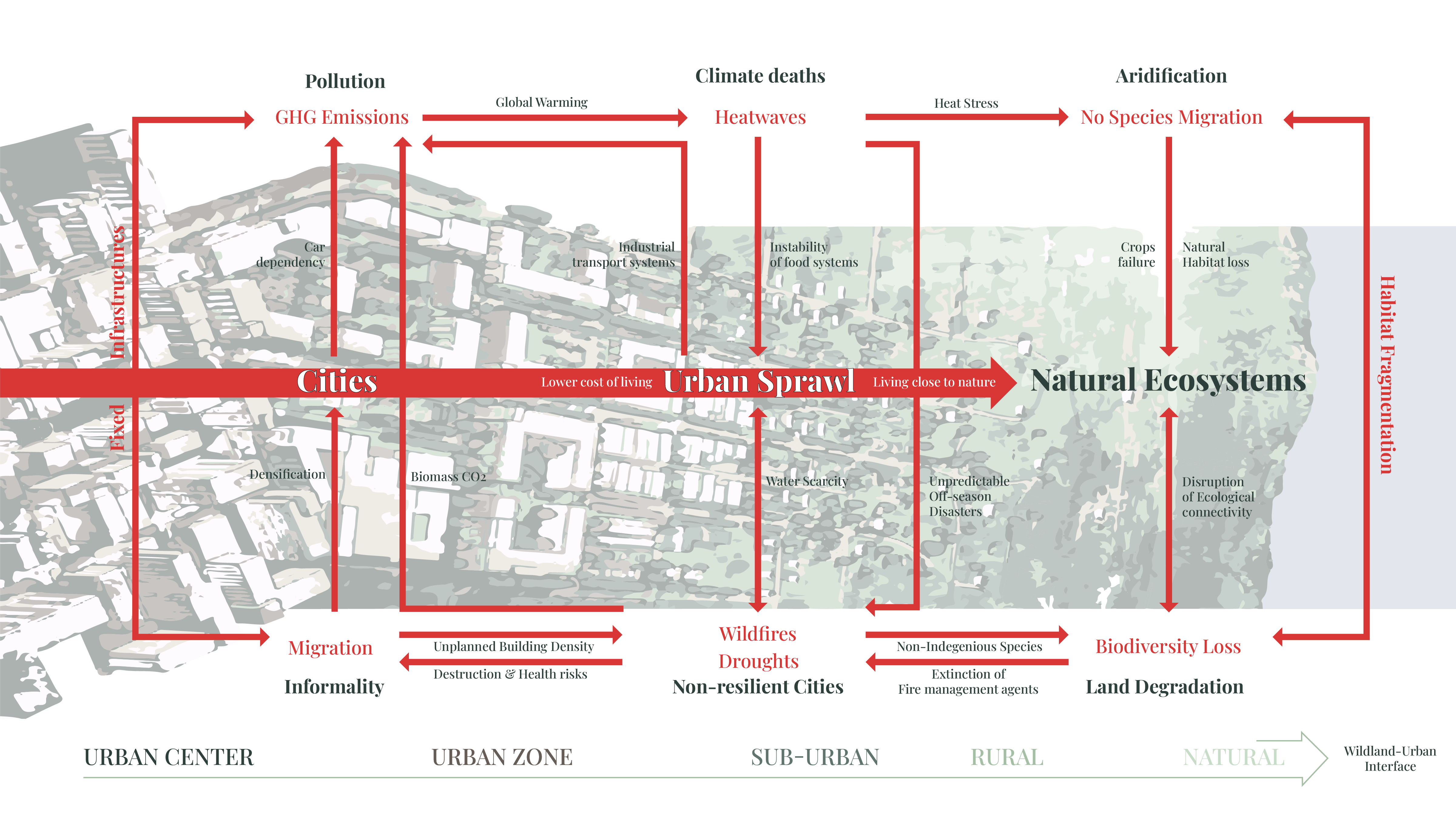
The world is experiencing a continuous trend towards urbanization, with more and more people residing in cities. However, this rural-to-urban shift has significant implications for the natural environment. Urban sprawl, characterized by the expansion of fixed infrastructures and the conversion of rural areas into urban landscapes, has caused severe damage to the environment. It disrupts natural ecosystems, leading to habitat loss, deforestation, and fragmentation. Additionally, urbanization contributes to the self-amplifying system of impacts caused by climate change.
FRAMEWORK | KEY FACTS
The urgency of addressing our impact on the earth’s metabolism is clear. To reverse biodiversity loss and confront the climate crisis, we must take immediate action. Increasing the world’s protected, representative, and well-connected landscapes by 50% by 2030 is essential. By doing so, we can preserve ecosystems, safeguard biodiversity, and mitigate climate change. These protected areas act as havens for nature, allowing it to thrive and restore ecological balance. The interconnectedness between nature, human well-being, and the consequences of our actions is evident. By destroying nature, we are ultimately causing harm to ourselves. This is particularly apparent in the context of droughts and wildfires. Droughts create a vicious feedback loop, intensifying the severity of wildfires while simultaneously exacerbating climate change and worsening drought conditions. The ramifications are dire, with poor air quality from wildfires resulting in premature deaths and an estimated 700 million people facing displacement due to droughts by the near future.

FRAMEWORK | POTENTIAL
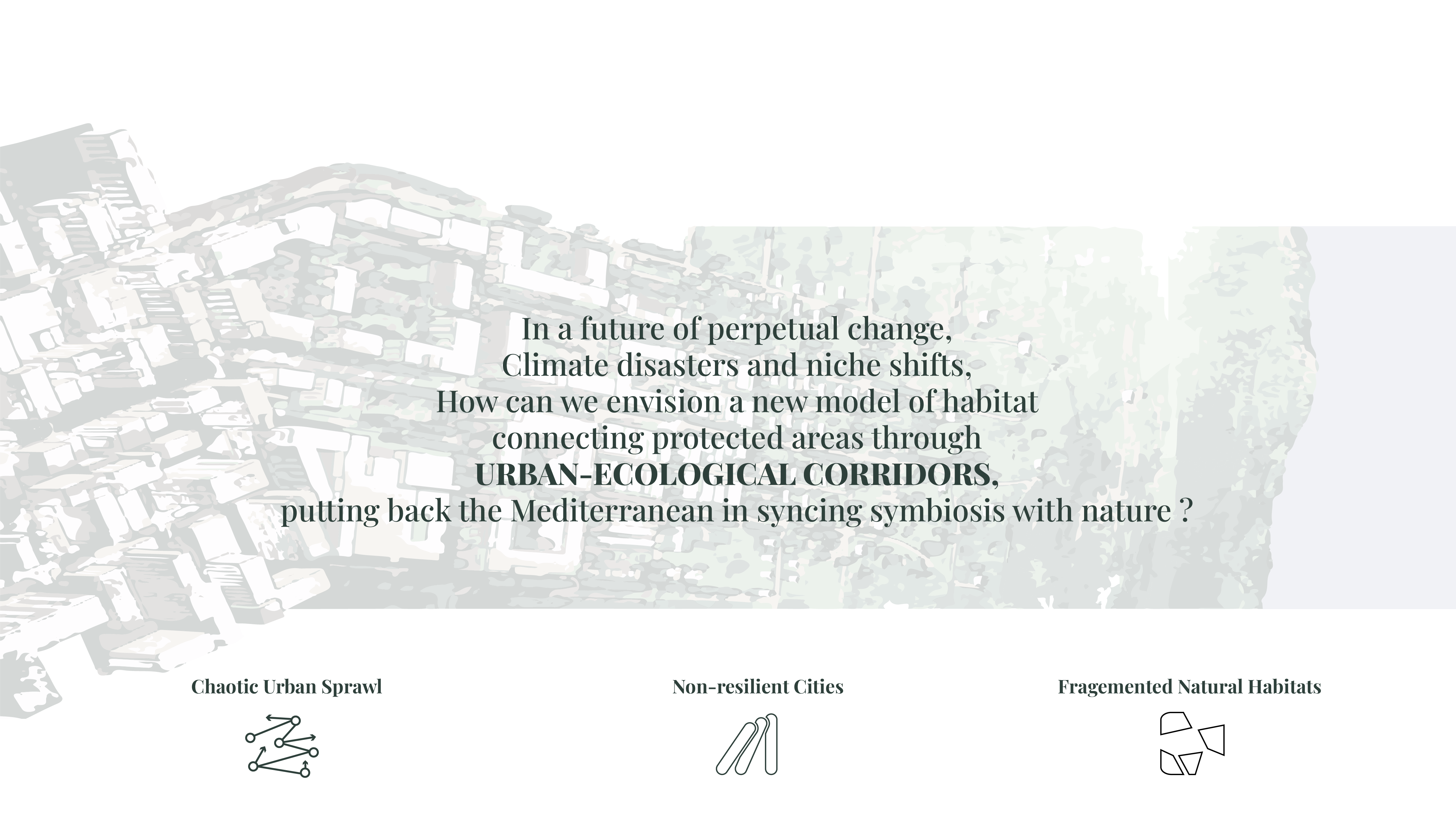
The interdependence of the two systems is fundamental. Are we ready to relinquish our control over nature? Will enhancing living ecosystems and driving back toward urban areas be the way to thrive and enhance resilience?

CULTURAL LANDSCAPES
Living ecosystems are intricately intertwined with the ever-changing interplay of biological and cultural diversity. J. Nogué (2011: 139) suggests that landscapes are not only shaped by nature but also by human culture, making them vibrant, dynamic, and constantly evolving. The concept of landscape encompasses three key aspects: spatial, temporal, and perception experience. Spatially, landscapes are formed through the layering and overlapping of territorial structures. Temporally, they exhibit a dynamic quality as a result of ongoing processes. Finally, the perception experience dimension recognizes that individuals engage with landscapes through their emotions, knowledge, and identity, creating diverse and subjective connections to the environment. Altogether, these dimensions illustrate the profound connection between living ecosystems, cultural diversity, and the ever-changing nature of landscapes.
CLIMATE CHANGE | BIOCLIMATIC SHIFTS
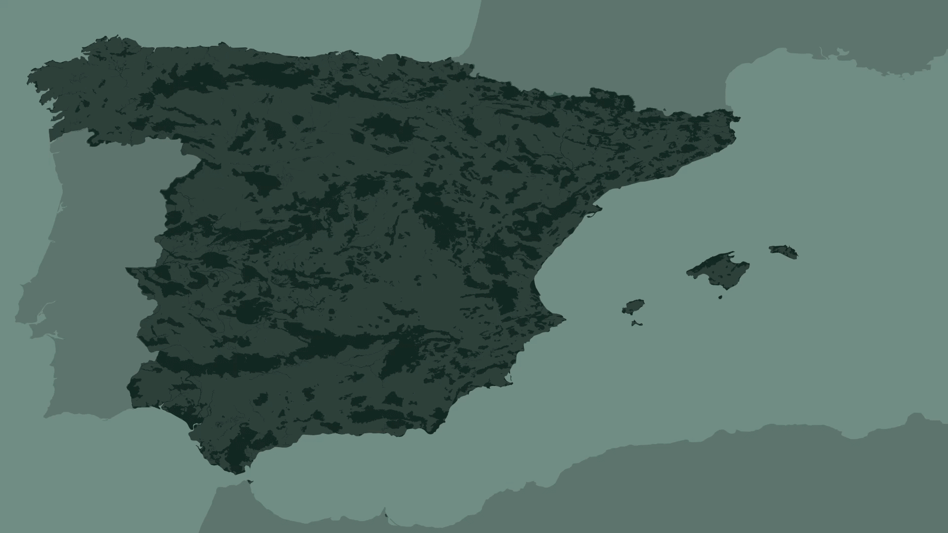
The Mediterranean basin stands out as an area of significant concern due to its heightened exposure and vulnerability to the impacts of climate change. Recognized as a climate change hotspot in 2014, this region is experiencing warming at a rate 20% faster than the global average. What makes the Mediterranean basin particularly susceptible is its proximity to various climatic conditions that are gradually shifting northwards as a result of global warming. This shift is expected to intensify desertification in North Africa and, in the case of high warming scenarios, also affect southern Spain. The combination of these factors underscores the urgent need for mitigation and adaptation measures to address the profound challenges faced by both human societies and natural ecosystems in the Mediterranean basin due to climate change.

SPAIN | UNCERTAINTY & FRAGILITY
Spain serves as a significant and compelling context to illustrate the impacts of wildfires. Among European nations, Spain has been the most affected, witnessing over 400,000 wildfires within the past three decades. While some of the burned areas have undergone restoration efforts to aid in the rejuvenation of ecosystems following wildfires, it is disheartening to note that certain territories have experienced repeated and severe fire damage. This repetition of destructive fires underscores the vulnerability of these areas and emphasizes the challenges faced in effectively managing and protecting them. The situation in Spain serves as a poignant reminder of the importance of implementing comprehensive wildfire prevention strategies and fostering resilient ecosystems to mitigate the devastating impacts of wildfires.
SCIENTIFIC INTEREST
SPAIN | FIRE CAUSES & MOTIVATIONS
The role of people in the current fire regime holds high relevance. It is evident that many wildfires in Spain are caused by negligence or accidents, particularly concentrated in the Mediterranean side of the country. This indicates the importance of human behavior and the need for increased awareness and responsible actions to prevent such incidents. Furthermore, an examination of the motivations behind wildfires in Spain has shed light on the significant contribution of agricultural practices to their occurrence. This highlights the necessity of intentional design and management of agricultural activities in these territories, ensuring that practices are implemented in a manner that minimizes the risk of wildfires.

SPAIN | LAND OWNERSHIP
The fragmented land ownership structure in Spain necessitates a fundamental transformation in the behavior of latifundios, large landholdings, away from monoculture farming and towards more sustainable practices. By embracing diversification and sustainable approaches, latifundios can contribute to the preservation of natural resources and foster ecosystem resilience. Concurrently, fostering the establishment of agricultural cooperatives among minifundios, small landholdings, is crucial in promoting collective action. These cooperatives facilitate collaboration among small-scale farmers, allowing them to pool resources, share knowledge, and jointly implement sustainable agricultural practices. By bridging the gap between large and small landholdings, this approach addresses the challenges posed by fragmented land ownership and promotes a transition towards a more sustainable and resilient agricultural system in Spain.

BIOCULTURAL APPROACH
I am selecting bio-cultural landscapes as a design tool to address these significant territories, as demonstrated by the transformation of the green great wall initiative from a wall of trees combating desertification to a network of interconnected biocultural landscapes. This temporal shift, starting at a small scale and leading to a bigger territorial impact, serves as evidence of our ability to establish new conservation areas within anthropogenic landscapes

DESIGN FICTION
In Spain, the focus of efforts has primarily been on the restoration of areas that have been affected by large fires. However, this realization has prompted a reevaluation of the current situation in Spain, envisioning it as a tabula rasa, a fertile ground for new possibilities. Specifically targeting burnt areas provides an opportunity to initiate the construction and growth of a new way of living, where a shift in behavior from reactive adaptation to proactive approaches can be fostered. Employing the design fiction framework presents an avenue to propose alternative interpretations of the present and shape preferred futures. By incorporating data-driven design, these speculative scenarios can be made as realistic as possible. Moreover, engaging stakeholders of today as citizens of the future scenario adds an element of participation and encourages collective responsibility in shaping the desired outcomes.
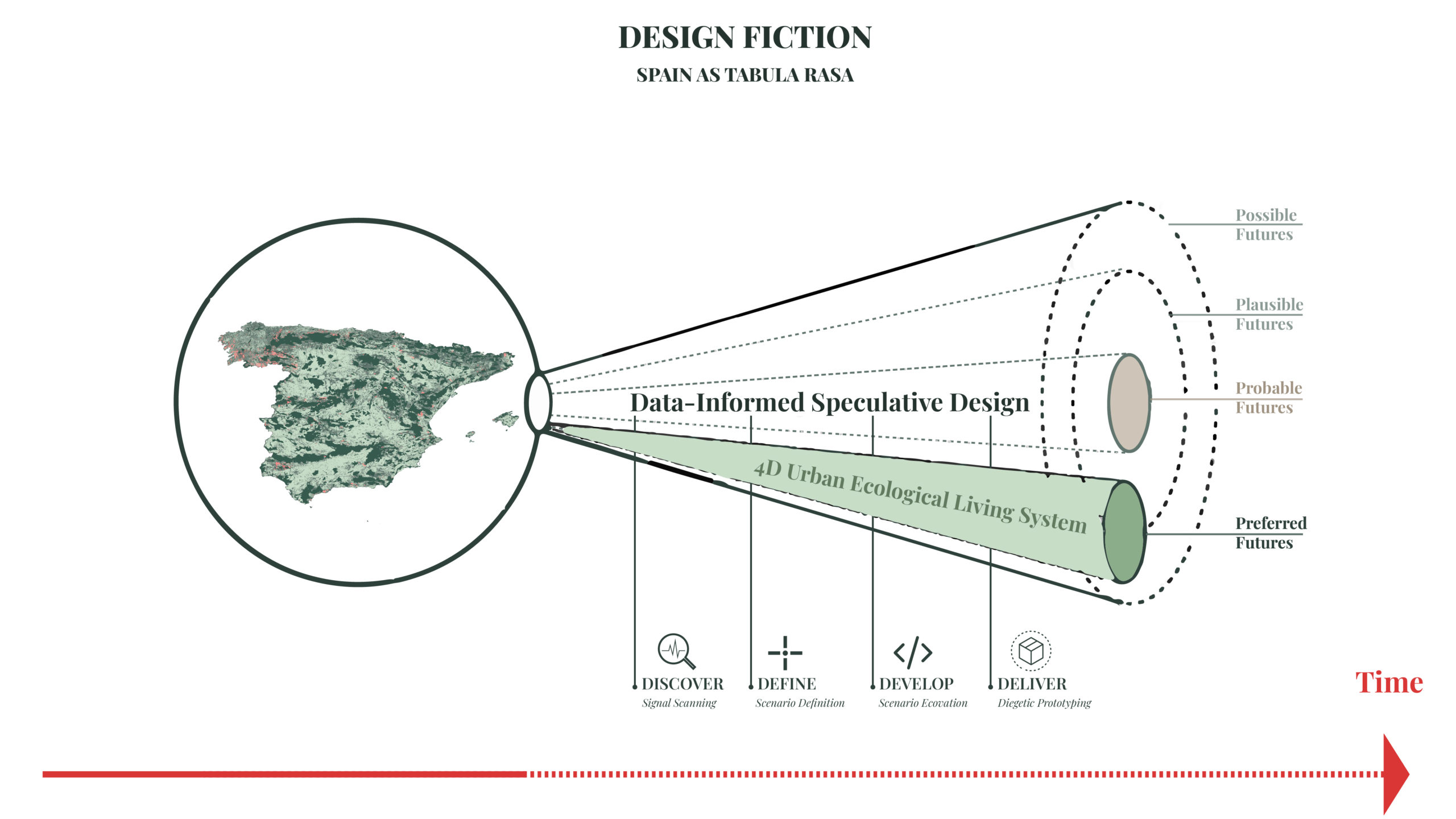
DESIGNING TERRITORIES IN TIME
The concept of nature serving humans has become a crucial aspect of landscape management, and there is an urgent need to reevaluate it through the lens of bio-political infrastructures and transition towards socio-ecological approaches. The objective is to propose a transformative process that fundamentally changes the human relationship with wildfires by designing territories in a temporal dimension, resulting in a 4-dimensional urban-ecological living strategy. This strategy emphasizes the enhancement of adaptive resilience through four key objectives: fostering synergy between mitigation and adaptation measures, establishing a feedback loop between human activities and the environment, ensuring scalability of interventions, and nurturing a symbiotic relationship between humans and nature. By embracing these principles, we can reimagine and create landscapes that facilitate a harmonious and sustainable coexistence between human societies and the natural world.
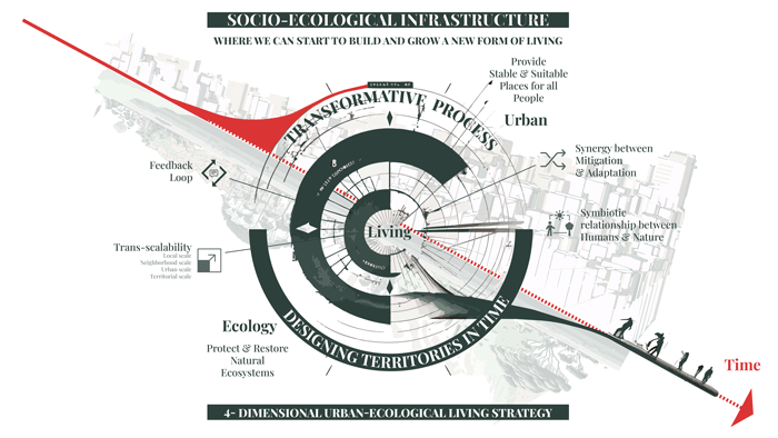
Designing territories in time encompasses two fundamental drivers: seasonality and biocultural diversity. Seasonality entails aligning agricultural systems with natural cycles, recognizing the importance of timing and synchronizing human activities with the rhythms of the environment. By considering seasonal patterns and adapting agricultural practices accordingly, we can optimize productivity, minimize environmental impact, and enhance the overall resilience of food systems.
Biocultural diversity involves integrating cultural intelligence with local environments to foster resilience in the face of future climate challenges. It acknowledges the rich knowledge and practices developed by local communities over generations, rooted in their deep understanding of the local ecosystems. By valuing and incorporating this biocultural diversity into decision-making processes, we can tap into a wealth of wisdom and traditional practices that can contribute to adapting and managing landscapes in sustainable ways.
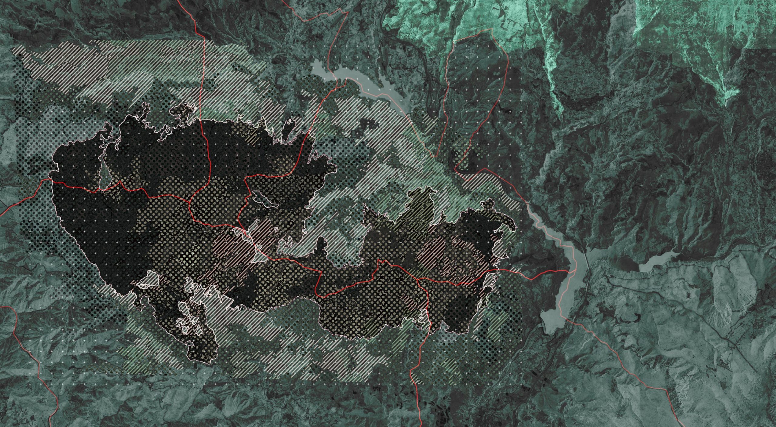
CONTEXT | GRANADA
The recent wildfire in Los Guajares, located in the province of Granada, holds significant importance in the context of bioclimatic shifts. This devastating fire, considered the worst in the area in a century, has highlighted the urgent need for restoration and rehabilitation efforts. The strategic significance of Los Guajares lies in its potential to foster ecological connectivity and enhance the conductance of anthropogenic systems, thereby facilitating the movement of species between protected areas. Understanding the implications of this wildfire allows for informed decision-making and the implementation of targeted measures to restore the landscape, mitigate future fire risks, and promote the coexistence of human activities and the natural environment in the province of Granada.
METHODOLOGY
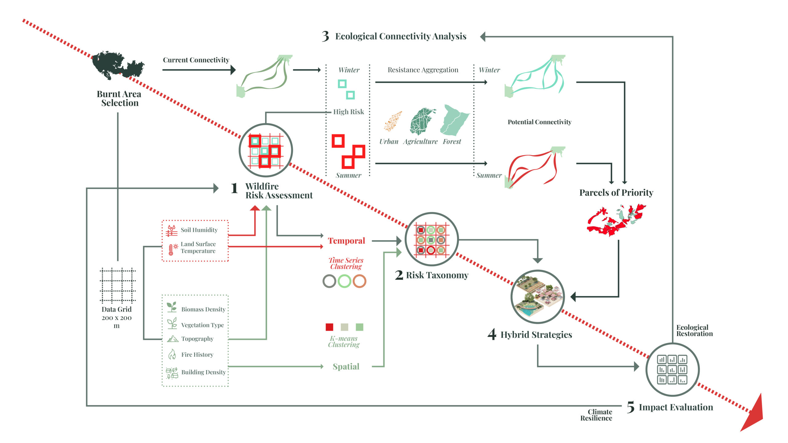
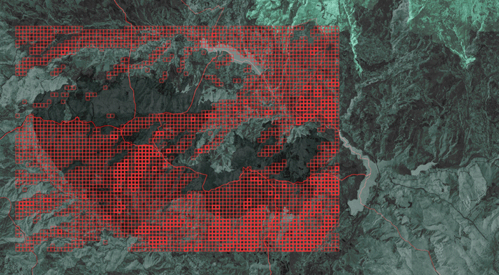
The strategic design of the territory in the context of wildfire risk involves a structured workflow consisting of several key steps. First, a data grid and two sets of indicators are utilized to assess the winter and summer wildfire risk across the territory. This assessment helps identify areas that require intervention to mitigate the risk of wildfires. Next, temporal and spatial clustering techniques are employed to refine the classification system for assessing wildfire risk, resulting in a more detailed and accurate understanding of the vulnerable areas.
Subsequently, an analysis is conducted to evaluate the potential conductance in high-risk areas. This analysis allows for the simulation of corridors over time, facilitating the identification of priority parcels that can serve as pathways for ecological connectivity and wildfire management.
The next step involves the development of intervention strategies based on the findings from the previous assessments. These strategies are designed to address the specific needs and challenges identified in high-risk areas, aiming to enhance climate resilience and promote ecological restoration.
Finally, an evaluation is carried out to assess the impact of the implemented strategies on climate resilience and ecological restoration. This evaluation helps measure the effectiveness of the intervention measures and provides insights for further refinement and improvement.
WILFIRE RISK INDEX
WILFIRE RISK ASSESSMENT | ANTHROPOGENIC & ENVIRONMENTAL FACTORS
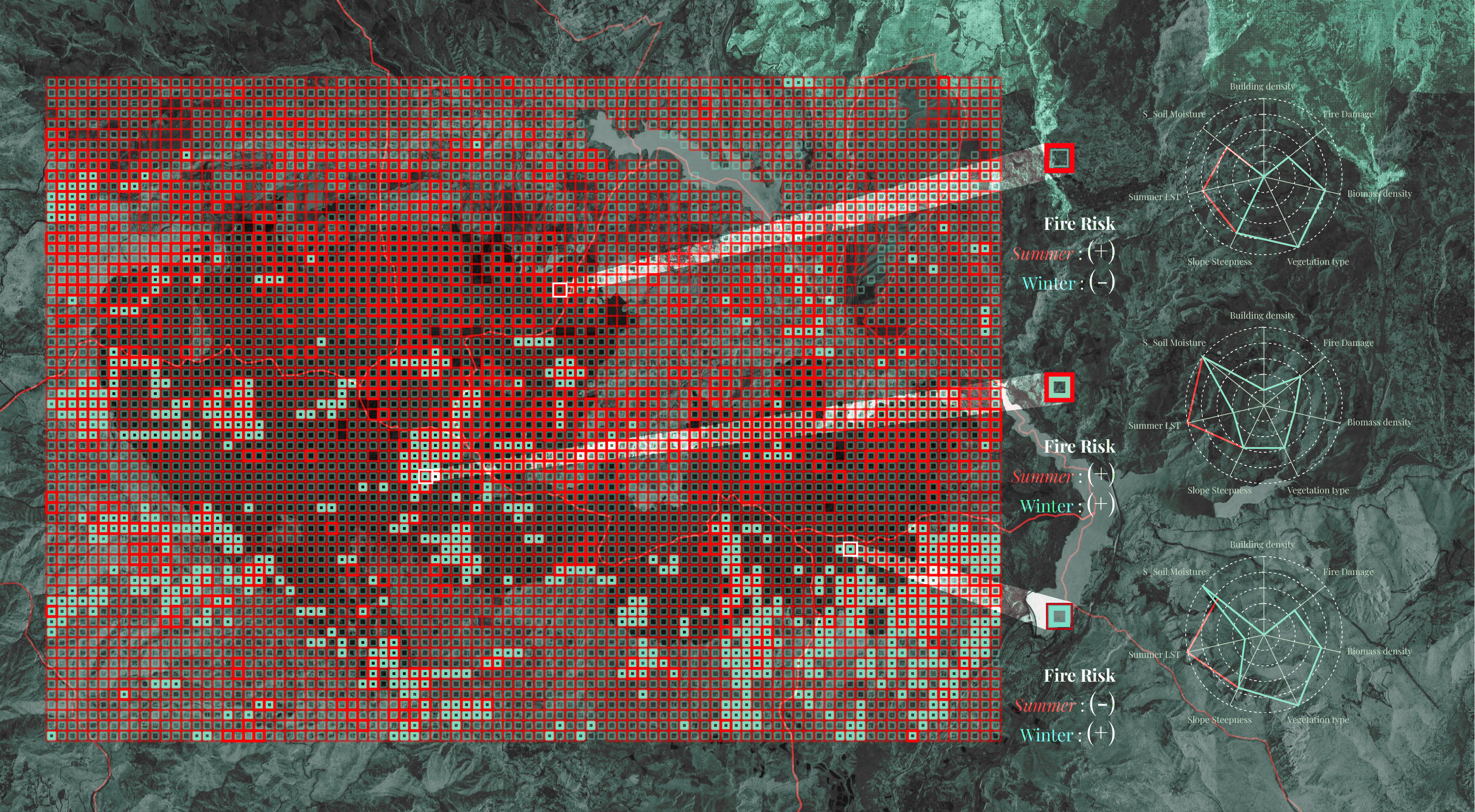
When assessing wildfire risk, it is important to consider both anthropogenic and environmental factors. Anthropogenic factors, such as building density and fire damage history, provide insights into the vulnerability of wildland-urban interfaces and areas with a history of fire incidents. Environmental factors, including slope steepness, biomass density, and vegetation type, contribute to the potential for fire propagation and intensity. Steeper slopes, higher fuel loads, and combustible vegetation increase the risk of wildfires. By integrating these factors into the risk assessment, a comprehensive understanding of areas at high risk can be gained, enabling the implementation of targeted strategies to prevent and mitigate wildfires, safeguarding both human communities and natural environments.
WILFIRE RISK ASSESSMENT | SEASONALITY FACTORS
Considering the dimension of seasonality in assessing wildfire risk reveals distinct areas of vulnerability throughout the year. Land surface temperature patterns during winter and summer highlight different regions prone to wildfires. Factors such as soil moisture play a crucial role in both seasons. In winter, soil moisture levels significantly impact wildfire susceptibility, as drier conditions increase the likelihood of ignition and rapid fire spread. Conversely, during summer, high temperatures and dry vegetation become dominant factors contributing to increased wildfire risk. Understanding these seasonal variations and their influence on wildfire dynamics is essential for effective risk management, allowing for targeted interventions.
The superposition of factors such as land surface temperature and soil moisture creates distinct risk patterns between winter and summer, as winter vulnerability is influenced by temperature variations and soil moisture levels, while summer vulnerability is primarily driven by high temperatures and dry vegetation conditions.

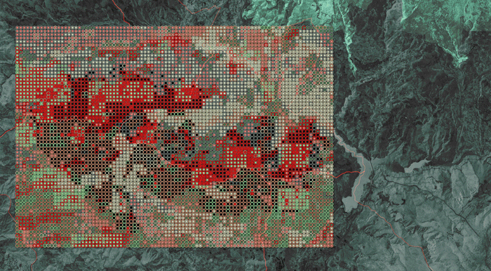
WILDFIRE RISK ASSESSMENT | SCORE
By assigning weights to each indicator and conducting a comprehensive analysis, the wildfire risk scoring in both winter and summer seasons can be obtained. The results reveal areas that are at risk either in one season or, in some cases, exhibit high risk in both seasons, depending on the specific factors assessed. This scoring system provides valuable insights into the temporal variation and severity of wildfire risk in different areas, allowing for targeted planning and management efforts to prioritize areas that are most vulnerable and require immediate attention.
RISK NEW TAXONOMY
RISK NEW TAXONOMY | SPATIAL CLUSTERING
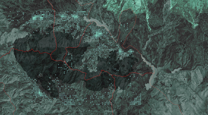
Developing a new risk taxonomy for the area was a critical step in understanding the diverse nature of wildfire risk. By employing spatial clustering analysis using the k-means algorithm, six distinct clusters were identified, each representing different types of areas with specific characteristics related to wildfire risk. These clusters encompass resilient wilderness areas, steep terrains, densely vegetated zones, urban areas on the outskirts or within villages, and regions with a history of fire damage. Understanding the unique attributes of each cluster allows for targeted strategies and interventions to be implemented
RISK NEW TAXONOMY | TEMPORAL CLUSTERING
Through the application of time series clustering techniques, specifically Euclidean distance and time-warping distance, the analysis identified five distinct clusters that capture the dynamic trends between seasons. This analysis not only reveals the impactful changes that occur within the data but also highlights the variations between areas of saturated soil and those at risk of erosion or runoff. By understanding these spatial dynamics, it becomes possible to discern the potential implications for wildfire risk, such as identifying areas more susceptible to ignition or spread.
RISK NEW TAXONOMY | PATTERN IDENTIFICATION
By overlaying the spatial and temporal aspects of the data, it was possible to identify and recognize the new risk taxonomy in a comprehensive manner. This integration allowed for the categorization of different areas based on their unique characteristics and risk profiles. Additionally, the analysis revealed the highest redundant pattern within the taxonomy, providing valuable insights into the commonalities and shared risks across multiple areas. The findings clearly indicate that a significant number of areas require the adoption of adaptation strategies, mitigation measures, and even preventive actions to effectively manage and reduce wildfire risks. This understanding is crucial for prioritizing resources and implementing targeted interventions to enhance resilience and mitigate the potential impacts of wildfires on these vulnerable areas.
CORRIDOR IDENTIFICATION
COMPUTER-AIDED ECOLOGICAL CONNECTIVITY | CURRENT
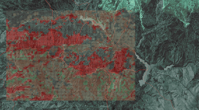
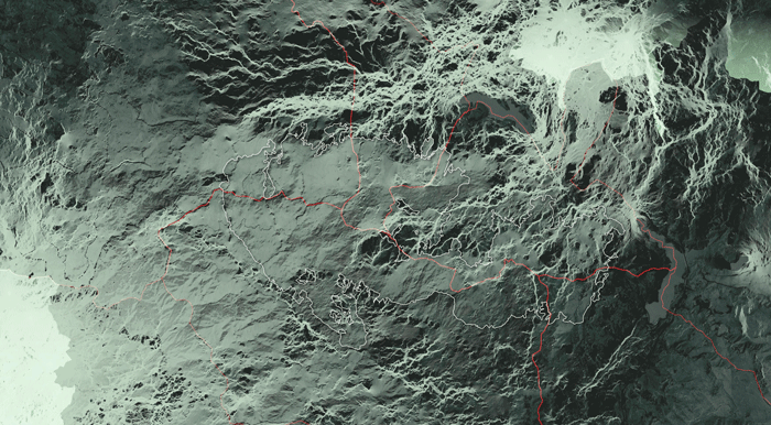
To further advance the analysis, the next step involves understanding the context through corridor identification. This is achieved by employing circuitscape, which takes into account the current land use with varying resistances. By utilizing this approach, the existing ecological corridors within the landscape can be effectively showcased. Additionally, overlaying the high-risk areas identified in both seasons on these ecological corridors provides valuable insights into the potential vulnerabilities and connectivity gaps that may exist within the landscape.

PARCELS OF INTEREST
In our approach, we focus on selecting specific areas for intervention based on their distinct spatial characteristics: urban, agricultural, and natural spaces. Each of these spaces presents unique opportunities and challenges for managing wildfire risks. To determine the priority areas for intervention, we aggregate them based on their potential conductance capacity, considering the high potential conductance of the natural areas.
We can see here how this categorization affected differently the corridor in winter & summer:

PARCELS OF PRIORITY
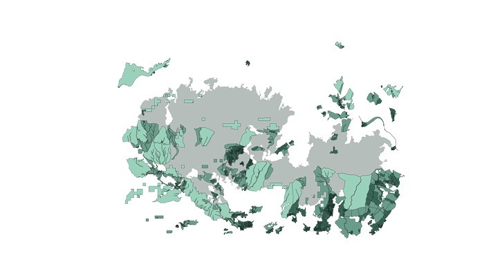
we calculated the potential performative connectivity within the selected territories, which allowed us to assess the degree of ecological connectivity in these areas. By quantifying the connectivity, we were able to identify parcels of priority within the natural and agricultural areas. These parcels represent key areas where interventions can have a significant impact on enhancing ecological connectivity, promoting species movement, and facilitating the exchange of ecological processes.
CORRIDOR OF INTEREST
After aggregating the data based on connectivity performance, we identified and selected parcels of priority within the landscape. These priority areas were assessed in both the winter and summer seasons, allowing us to identify areas that consistently require intervention to manage wildfire risks. By highlighting these areas, we can focus on developing a corridor of priority that exhibits versatility and importance in both seasons. This corridor showcases the potential for urban ecological integration, highlighting the patchwork of areas with high ecological potential within urban environments. It is as well recognized through the new taxonomy to help understand the specific type of strategies of each zone.

STRATEGIES & INTERVENTIONS
After understanding the spatial characteristics, it is easier now to delve more into the required strategies and interventions.
GOALS & STRATEGIES
In our approach, we prioritize three significant goals: climate resilience, ecological restoration, and socio-economic sustainability, all of which are crucial in addressing the challenges faced by these territories, particularly in relation to wildfires, droughts, and biodiversity loss. To achieve these goals, we identify the main methods to tackle these issues effectively. By understanding the specific challenges and their underlying causes, we can develop a set of tailored interventions that are appropriate for each context.
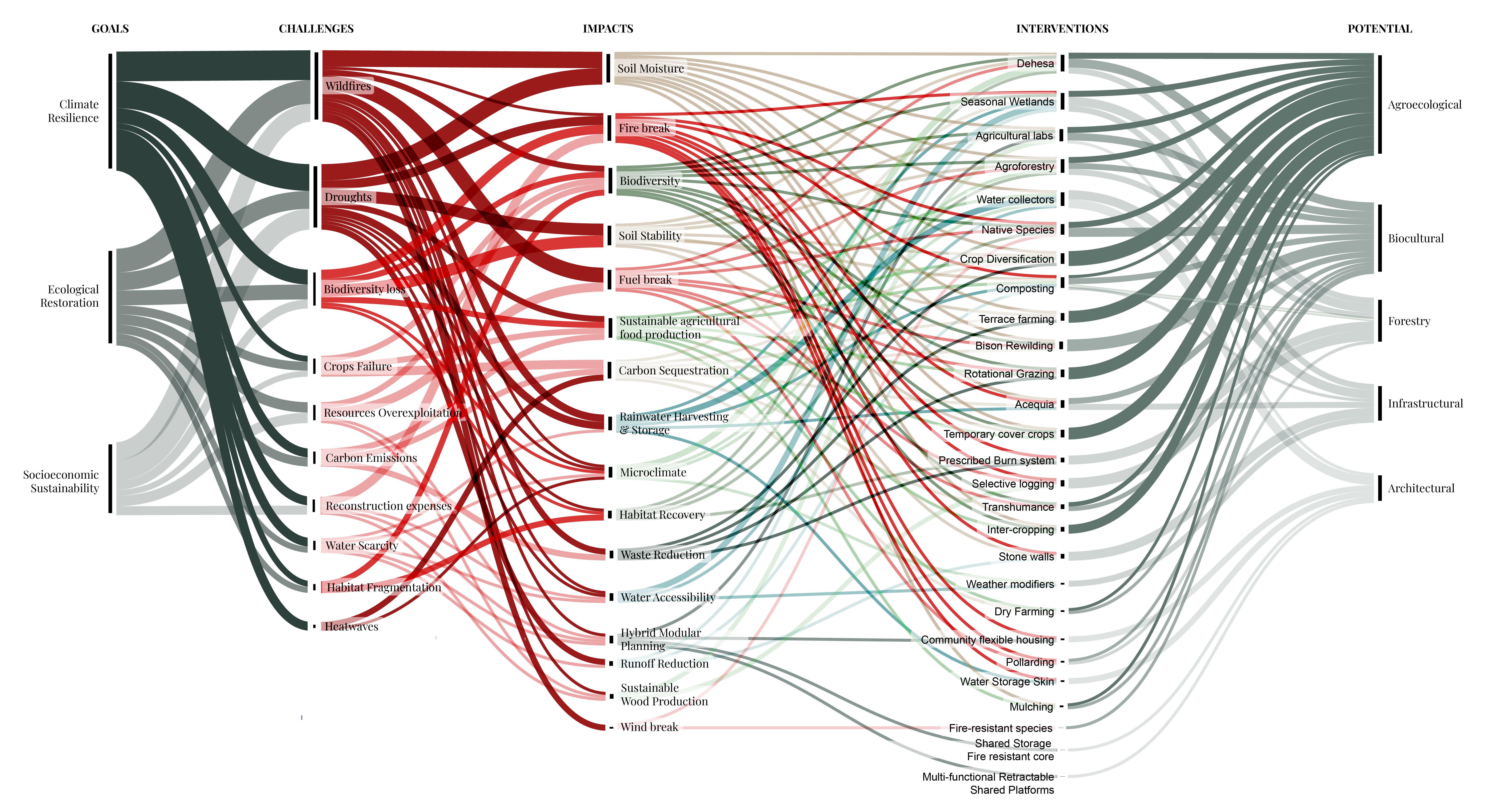
CATALOGUE OF INTERVENTIONS
Interventions need to be understood and categorized based on the strategies of adaptation, mitigation, and prevention in relation to the new risk taxonomy. Contextual considerations play a vital role in determining the appropriate interventions for each territory.

