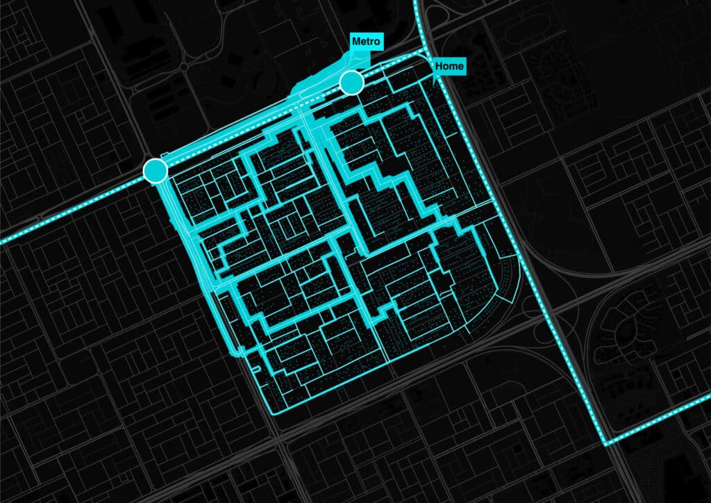
Riyadh, the capital of Saudi Arabia and city of 8 million residents, is investing heavily in upgrading its mobility network. Tasked with designing an intervention in a 2km by 2km block in the northwest part of the city, our team began by evaluating the existing mobility network.
We found that public transit in Riyadh is underutilized, largely due to the long distances many residents must travel to transit stops and a local preference for private cars leading to traffic congestion. Traffic is not only a transit issue, but a public safety one as well. Riyadh is now investing in traffic safety, with the government is aiming to have less than 5 traffic fatalities every 100,000 inhabitants by 2030. Active transport options are lagging in Riyadh, in part due to the climate, but also due to lack of infrastructure. Autonomous electric vehicles can act as a support to these systems, available as a back-up option to active transport adopters. Authorities are already pushing the city in this direction, with the Transportation General Authority setting the goal of 25% of autonomous transport vehicles in Saudi Arabia by 2030.
The city is also investing heavily in its public transport infrastructure. Thus far, it has invested 25 billion USD into its six metro lines, which have recently opened in January 2025. When taking a closer look at the metro network, we saw that it leaves a majority of its neighborhoods under-served. How can Riyadh go further in encouraging active transport and public transportation?

Understanding Riyadh’s context, we developed the following priorities:
Mobility
Connectivity to public transport and local sites
The broad connectivity provided by the metro does not extend to the internal areas of the sites.
Making these areas friendly to active transport and providing options that are faster than car transport would foster a behavior change that would make last-mile connectivity scalable throughout Riyadh.
Inclusion
Creating urban pathways for women and children
Women, who make up 37% of Riyadh’s population, and children, who make up 25% of the population,1 spend much of their time near the home and lack walkable access to their local public spaces.
Designing pedestrian streets and public micro-
mobility options for women and children will expand their access to their neighborhoods and encourage behavior changes for the future of Riyadh.
Emissions reduction
Reaching net zero by 2060
Saudi Arabia’s goal of reaching a net of zero carbon emissions by 2060, as well sourcing 50% of their energy from renewable sources by 2030,2 requires infrastructure changes throughout its major cities.
By offering shared mobility options and opportunities for active transport, Riyadh can reduce its over-reliance on cars and fossil fuels.
We also took inspiration from the superilla and 15 minute city planning concepts to understand current best practices and goals when designing for mobility.
Superilla principles
Bus stops: 400-500m distance from any point to a bus stop and placing bus stops on corners for easy access.
Turn around time: The time a car takes to turn around must be similar to the time taken to turn around a block on foot
Liberation of space: Enable access to recreation, entertainment, culture, exchange, and democratic expression (agora), and ensure mobility rights, even on foot.
15 minute city
An urban design concept that proposes residents have access to essential urban services within a 15 minute walk or bike.
Developed primarily to reduce carbon emissions by decreasing motorised commuting time, proponents also argue the creation of these multi-use neighborhoods will increase resident quality of life. The concept has important implications for public health of cities as residents reap the benefits of increased active transport (C40 Knowledge: Cities, Coronavirus (COVID-19) and a Green Recover; The Case for a Green and Just Recovery, 2020).
2.1-month increase in life expectancy for public transport commuters based on 12-minute walks to and from transport for weekday commuting
3.6-month increase in life expectancy for cyclists and pedestrians based on 40-minute commute totals everyday.

However, these principles cannot be applied directly from a city like Barcelona to a city like Riyadh. The scale of each alone requires adapting these concepts to the local context. To do so, we began by understanding the transport network within the block.


We next determined goals to guide our design:
External
Connecting key public spaces and transportation nodes
Finding convenient connections between important neighborhood community sites: Mosques, schools, and parks.
Placing AV pick-up and drop-off points along the loop.
Activating the superblock
Leveraging walkable paths between homes and important facilities.
Reclaiming underutilized spaces to encourage cultural shifts towards walking, biking, and taking public transport.
Internal
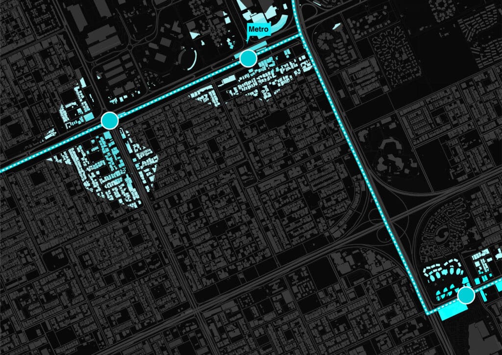
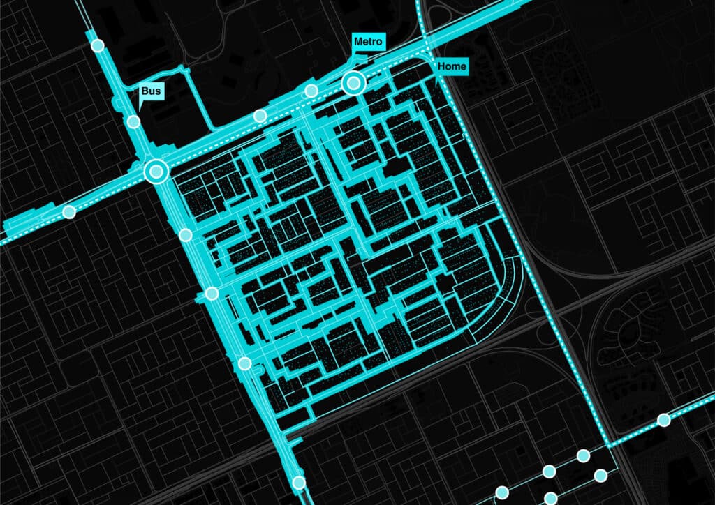
Connect to Metro
Link loop to existing bus stops and the nearby metro station for smooth connection from the block to the rest of the city.
Connect to neighboring blocks
Pedestrian bridges and traffic light intersections to ease crossings between blocks.
With these goals in mind, we began to look at the different facilities within the block and the most direct paths connecting the homes within the block to these anchors.
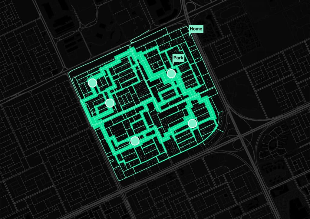

Concept: pedestrian centered green loop for micro-mobility that links the interior of the block, public spaces, and existing public transportation infrastructure and allows movement outside the block.
Near-term
Connect the block with the metro station. Promote internal connectivity.
Medium-term
Leverage internal connectivity and links to public transport to reduce private mobility to 60% in they block. Facilitate connections between blocks
Long-term
“The concept of superblock makes sense when the superblocks form a network that covers the entire city”
(Superilla Barcelona in Cocco, Scaglione y Stefano, 2024)
Reduce car usage to 40% by replicating the superblock in other areas of the city. People do not walk more than 250m to access public transport networks and public spaces.
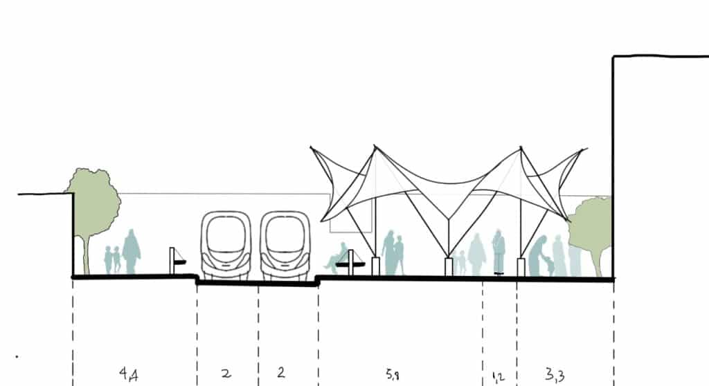
Riyadh Superblock: Green Loop Design


Pedestrian bridges would connect adjacent blocks, facilitating internal and external integration.


Street to pedestrian loop transition
Current situation
Traffic and parking dominates the entire street with little room for pedestrians or other modes of active transport.
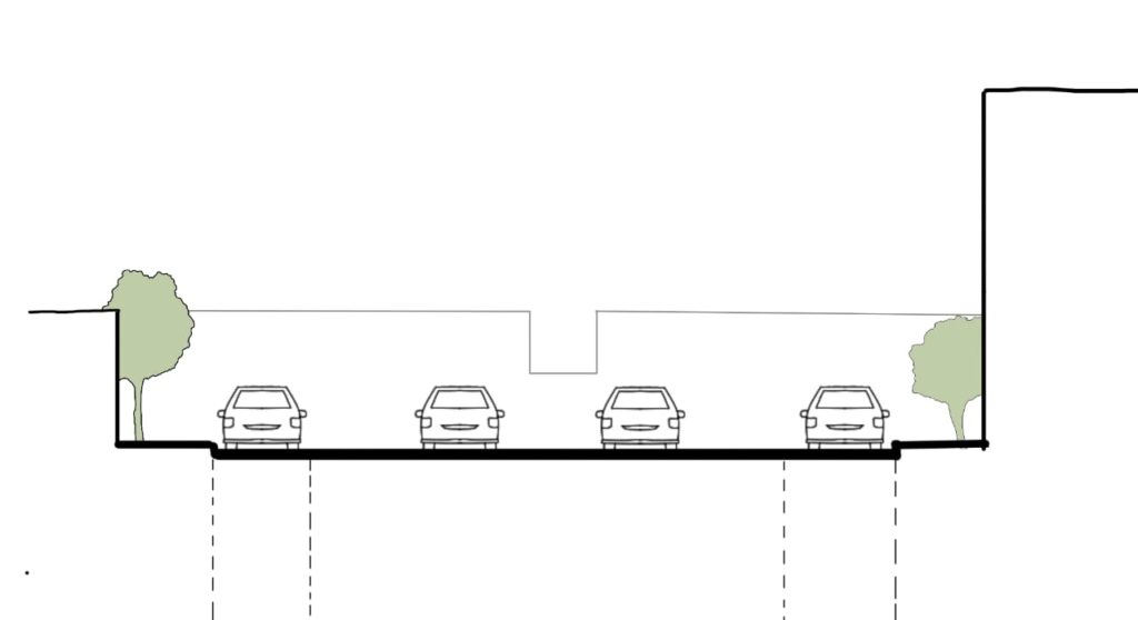
Stage 1
Traffic reduced to two lanes in each direction to reclaim space for pedestrians.
Street parking will be displaced to the side streets.

Stage 2
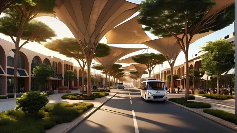
Bike lane is created to offer the space for residents to adopt a new form of active transport. Driving lanes are reserved for 6-person AV only.
Green elements, particularly indigenous species, are included in the space.

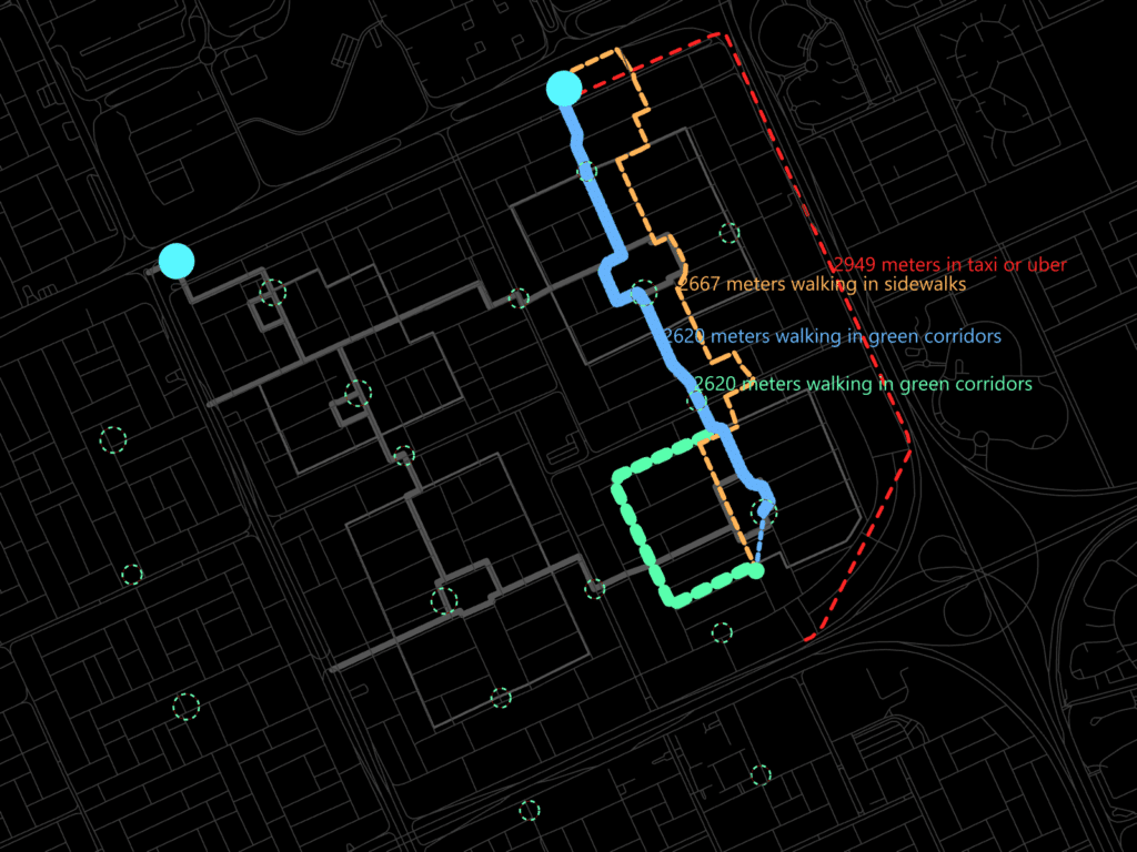
Riyadh Superblock user journey
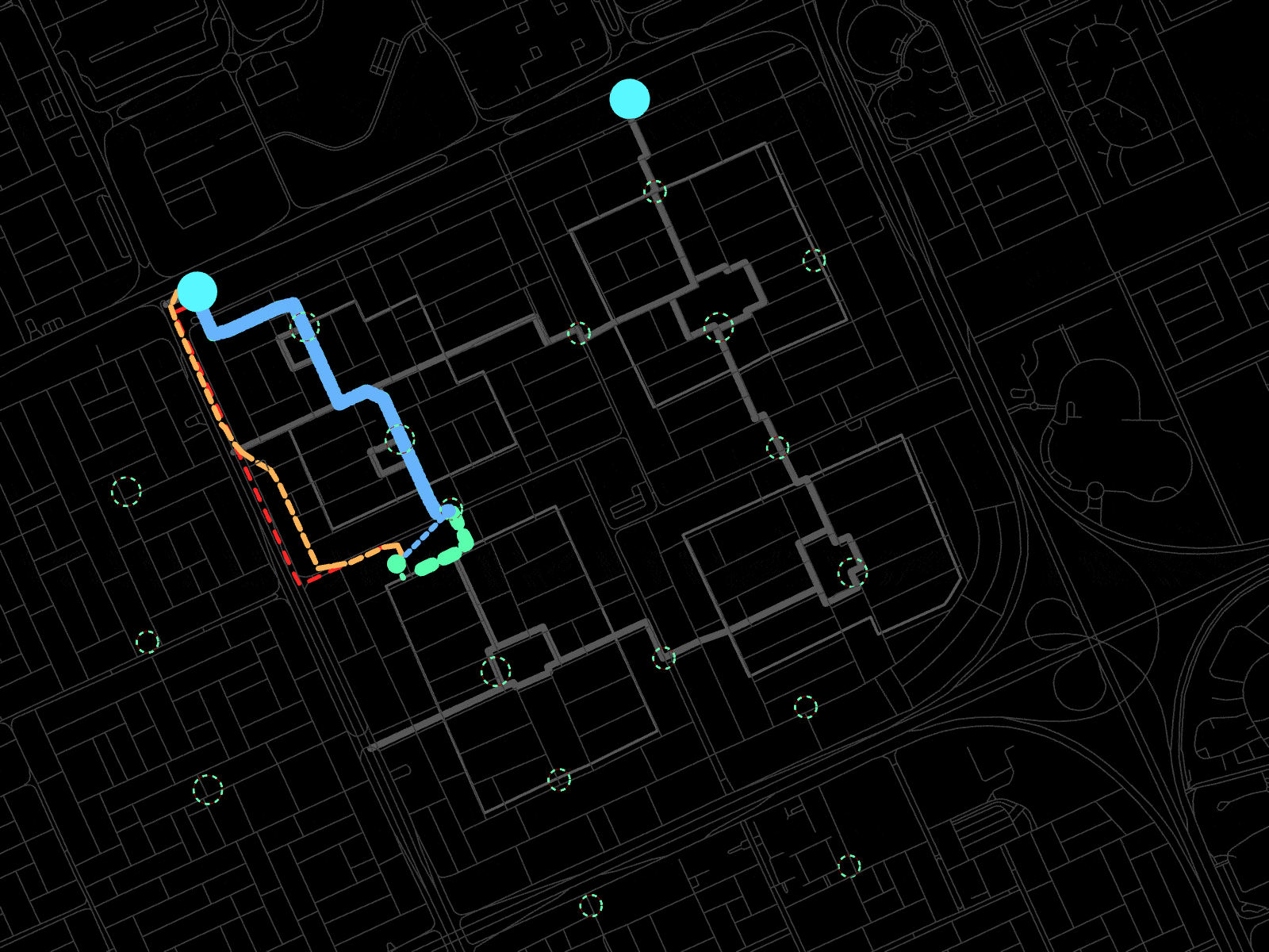
We finally wanted to check our design to understand how neighbors might use the green loop. We created different scenarios for two unique users and used a trip choice tool to map out their travel options. We then input the user profiles into an LLM to simulate user preferences. These models considered Riyadh’s climate, travel distance, travel mode speed, and renderings of experiences on each path.
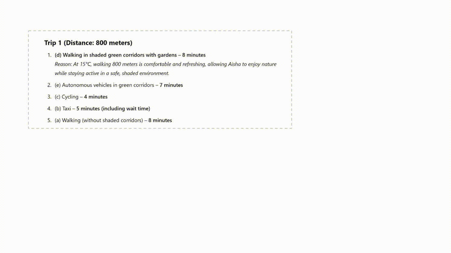
Aisha, 32, is a homemaker in Riyadh, lives with her family and needs to run errands in other areas of the city.
Aisha currently has two options to get from her home to the metro. With the superblock design, Aisha has two new options, allowing her to more comfortably travel on foot.
Prompting an AI agent with Aisha’s profile, we got potential preferences:
Summer:
#1 Autonomous vehicles in green corridors
In the 40°C heat, traveling 800m is too exhausting via active transport. AVs provide a comfortable, air-conditioned ride in 7 minutes.
#2 Taxi or Uber
#3 Walking in shaded green corridors
Winter:
#1 Walking in shaded green corridors
At 15°C, 800m is a comfortable 8-minute and refreshing walk, allowing Aisha to enjoy nature while staying active in a safe, shaded environment.#2 Autonomous vehicles in green corridors#3 Cycling
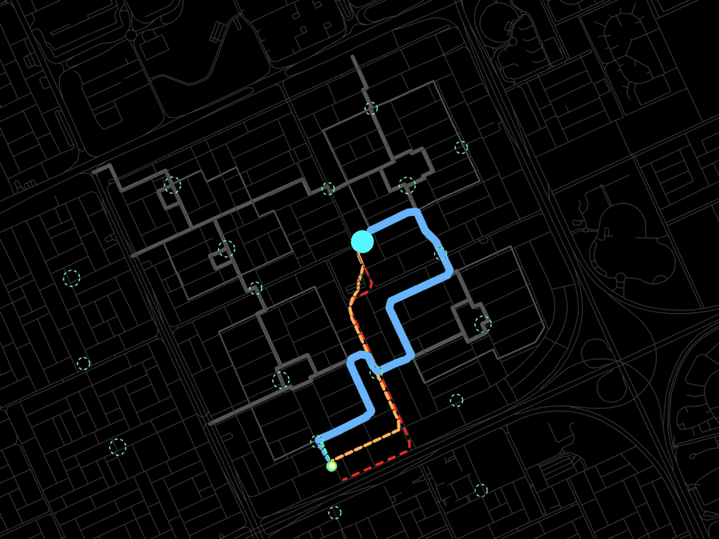
Omar, 15, is a curious and energetic schoolboy in Riyadh, living with his parents and older sister. He loves football, video games, and exploring new science experiments.
Omar currently has two options to get from his home to his school, but the superblock design gives him three new options: riding in an AV, cycling and scootering in the green loop, and walking in the shaded walkways of the green loop.
Prompting an AI agent with Omar’s profile, we got potential preferences:
Summer:
#1 Riding in a shared AV
In the summer heat, sitting in the cool car is much more pleasant.
#2 Riding a taxi or Uber
#3 Cycling in green corridors
#4 Walking along green corridors
#5 Walking on sidewalks
“Too much sun, too much heat! I just want to get inside as fast as possible!”
Winter:
#1 Cycling in the green loop
“Biking in winter is awesome! The air feels fresh, and I don’t get too tired!”
#2 Walking along green loop
#3 Walking on sidewalks
#4 Riding in a Shared Autonomous Vehicle
#5 Riding a taxi or Uber
“Taxis are okay, but when the weather is nice, I don’t want to just sit inside!”
Human bias analysis in the case of urban mobility using digital twin and LLMs (AI agent)
To conduct these analyses, we developed a tool that analyzes trip options given any point within the block.