
GREENOVA was developed by Dominik Sawallisch, Karim Abillama, Andrea Gnaccarini, Manuel Harm, Maria Magkavali, Moritz Knappinger, Moritz Dahlmanns, Davide Casalino, with the support of trainers from the Vienna University of Economics and Business, the Institute for Advanced Architecture of Catalonia, the University of Genoa and ALDA, during the Green Skills for Cities project, co-funded by the Erasmus+ programme of the European Union.
Implementing Nature-Based-Solutions on Via Casaregis for the benefit of all
INTRODUCTION
This project provides a comprehensive analysis of the implementation of nature-based
solutions along Via Casaregis in Genova. The following showcases the meticulous integration of
sustainable and environmentally friendly practices, which have led to the remarkable transformation
of the road into an enhanced and verdant environment. Through strategic planning
and active community engagement, this project has effectively achieved a harmonious equilibrium
between infrastructure development and the preservation of natural elements. The outcomes
exemplify our commitment to fostering a greener and more vibrant space while promoting long-term
sustainability and enriching the overall well-being of residents and visitors alike.
PROBLEM DEFINITION
The city center of Genova is grappling with a critical issue that involves the detrimental
effects of the heat island phenomenon and an escalating flood risk. With temperatures
soaring to alarming levels, reaching up to 34 degrees Celsius, the dense city center has
become an epicenter for heat accumulation, intensifying the urban heat island effect. This
problem arises from the prevalence of heat-absorbing surfaces like concrete and asphalt,
along with limited green spaces and vegetation. Consequently, residents and visitors in the
city center face extreme heat conditions, endangering their health, compromising livability,
and amplifying energy demands for cooling systems.
Simultaneously, Genova faces an escalating flood risk, particularly within its city center. The
convergence of intense rainfall events, inadequate drainage infrastructure, and the
proliferation of impermeable surfaces has augmented surface runoff and flooding
occurrences. The combination of elevated heat and flood risks poses a grave threat to the
resilience, safety, and well-being of the city center.

Car occupation:
The issue of car occupation in Via Casaregis, excluding pedestrians,
presents a significant challenge to the functionality and safety of the area. With a parking
area spanning 2,176 square meters and a road measuring 10,790 square meters, the
limited parking space often leads to cars occupying the road, diminishing the flow of traffic.
Unfortunately, this encroachment affects the designated pedestrian area, which covers only
1,632 square meters. The dominance of cars hinders pedestrian accessibility and
compromises their safety.
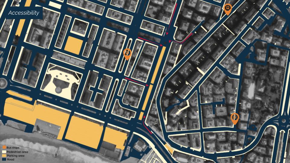
Accessibility:
Via Casaregis is accessible from the major arterial road, Corso Italia is also
connected to two residential roads, namely Costantino Mori and Salita Francesco Vignola.
Related to the public transportation, the presence of nearby bus stops Rimass/ Morin (Bus
20), Nizza2/ Scalinata Guerrieri (Bus 36) and Battisti/ Scuole (Bus 36) provide further
accessibility for commuters and residents to the space
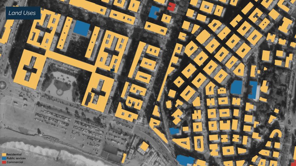
Land Use and Greener:
Via Casaregis Road predominantly features residential
buildings, serving as the primary land use within the area. The presence of housing
structures signifies the neighborhood’s role in accommodating the local population. One
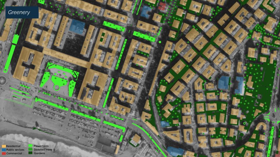
significant concern observed in the analysis is the notable scarcity of green spaces. The
absence of trees, plants, and open green areas contributes to the exacerbation of the heat
island effect in the neighborhood. With a dominance of concrete surfaces, the absence of
natural elements results in increased surface temperatures and reduced natural cooling
effects.
THE PROPOSAL
Project objectives based on residents request
Spatial Planning
Flexibles spaces
The project is conceived around the idea of flexible spaces. A series of squares are
deployed along the park. These spaces, placed in front of bars and restaurants, could be
used both by citizens to organize public events and by local and food facilities owners who
during the summertime could desire an external place to settle their tables.
The inspiration comes from the Giardini Luzzati in Genoa, where this flexible space is able to
offer spaces to stakeholders and citizens into a mix of flexible activities.
Parking lots
Despite the municipality’s interest to remove the parkings in the area it has been decided to
keep some of them, the shops that overlook on the street will always need goods delivery
and it is also nice for the citizens living in the area to have some parking spots nearby;
however the parking’s distribution has been modified to alter the cars’ flow and slow down
the traffic creating a safer area and allowing to people to across the street safely, also bars
and restaurant waitress in this way could easily reach their exterior spaces.
Mobility
Inside the park are provided a bike lane and a pedestrian path. Considering the future
project Waterfront di Levante by the Renzo Piano Building Workshop, it is available inside
the park roads to bypass the traffic area and allow pedestrians and bikers to have a safe
connection from Renzo Piano’s proposal to the city.
Vegetation
The plants inside the project are deployed along the streets. This deployment provides a
double function because it allows a direct absorption of CO2 and it isolates the area from
noise and cars creating a safety island in the middle of the street.
In the south part it is present a large green area which was conceived to host a huge
biodiversity and different kinds of nature based solutions.
Generally the plant distribution is thought to have a diversification of plants along the park
which goes more coastal upon approaching the coastal area.
Nature Based Solution
Renature Native Species:
All vegetation related measures will be carried out with native
species. The Canopy i.e. should be provided by hebera Helix or/and Vitis Vinifera. By this we
want to create an intact habitat for the native faunatic species and contribute to a rise of
Biodiversity in this area. Also we dont bring new (alienated) species into the area, which
could have an unsuspected impact on the ecosystem or even become invasious.
Furthermore, these plant species are already adapted to the environmental conditions and
they can be included into the environmental education approach of the project.
Pollinators biodiversity:
Since pollinators are essential for a healthy and functioning
ecosystem, we want to increase the size of the green space and the diversity of native plants
used there. The street should perspectively also function as a corridor from the planned
green space at the coastline to already existing green inside the city.
Permeable Pavement:
Bike and pedestrian lane will be built on permeable pavement, so
that it can infiltrate water at light precipitation and get into the soil. Also by that groundwater
can be replenished and canalisation systems are relieved. It also contributes to decrease the
risk of flood events.
Tree Canopy Restauration:
We want to implement trees to bring shadow and fresher air for
the people and to increase the quality of stay. This will be the part of the project, which will
need the most time, so there will also be trellis covered by plants to provide shadow for the
gastronomically used spaces.
Biodiversity Mirco-habitats:
To attract local faunatic species we want to build
micro-habitats for them. For example insect hotels, bat and bird-houses and space for
reptiles.
Unmanaged Areas:
Some green spaces, which do not have plant species that grow a lot
(i.e. with annual plants) should be left unmanaged for the processes of nature. These areas
attract pollinators and also other local species as they are not frequented and used by
humans. Also the inhabitants can watch real natural processes over the year as part of
environmental education.
Project Proposal division
In order to create a smooth changement in the neighborhood the project has been
divided into three phases.
These phases are chosen considering the kind of interventions developing in the area.
Nowadays the area is mostly characterized by parking. For this reason, there will be a slow
reduction in the years in order to not create disease in the population.
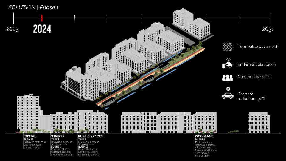
2024
In 2024 there will be the first parking reduction with the introduction of the first public spaces
and a canopy. The canopy provides shadows on the street keeping the parking resulting in a
flexible space, between the parking spot and the public area.
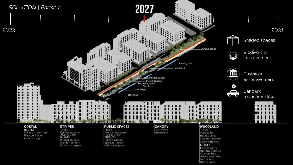
2027
In 2027 there is the introduction of the bike lane, pedestrian path, and flexible spaces.
Some of the parking spots are kept, and some others are modified in order to create a controlled
car flow.
The vegetation reached biodiversity diversification and now is just waiting to grow.
2030
In 2030 the project is complete.
The parking lots are entirely modified, the flexible areas are completed and the public areas
are all present.
The vegetation is completely mature and ready to be a green lung inside the city.

SYSTEM EQUALITY
In the development of a nature-based solution for an urban design project in Genova, Italy, specifically in Via Casaregis, achieving system equality between social, economic, and environmental aspects is of paramount importance. By integrating nature into the urban fabric, we aim to create a harmonious and sustainable environment that benefits all stakeholders involved. This entails ensuring equal access to green spaces and recreational areas for residents of all socioeconomic backgrounds, fostering social cohesion and well-being. Additionally, economic considerations must be taken into account, promoting equitable opportunities for local businesses and generating employment through the project’s implementation. Simultaneously, preserving and enhancing the natural environment is crucial to mitigate the impact of urbanization, promoting biodiversity, and creating a resilient ecosystem. By prioritizing system equality across these three dimensions, the nature-based solution in Via Casaregis will contribute to the overall well-being of the community and provide a model for sustainable urban development.

We would like to express our heartfelt appreciation to all the members of our project group (TU Wein: Moritz Knappinger – Spatial Planner, Manuel Harm – Business Communication, Dominik Sawallisch – Business Informatics, FU Berlin: Moritz Dahlmanns- Environmental scientist, University of Genova: Andrea Gnaccarini – Architect, Davide Casalino – Nature Specialist) as well as the Municipality of Genova and the Greenskills 4 Cities organization, for their invaluable contributions to the Via Casaregis nature-based urban design project. Each team member brought their unique skills, knowledge, and dedication, working collaboratively to bring this project to fruition. We extend our gratitude to the municipality for its vision and support, which laid the foundation for this transformative initiative. Special thanks go to the Greenskills 4 Cities organization for their partnership and commitment to sustainable urban development. Their guidance and resources have been instrumental in shaping the project’s outcomes. We are deeply grateful to all these individuals and organizations for their unwavering support and collective efforts, which have truly made a difference in creating a more sustainable and livable community in Via Casaregis.
