Letamendi’s Organic Operations Plan
Introductory Studio G1
The Future of Density – Rethinking the Cerdá Block
Faculty: Carmelo Zappulla, Sebastian Amorelli, and Amin Bigdeli

Housing is one of the most urgent challenges of the twenty-first century. Ildefons Cerdàʼs nineteenth-century plan set the foundations for Barcelonaʼs future, imagining equal access to light, air, and infrastructure. The question is how this urban unit can evolve under conditions Cerdà could not foresee: climate crisis, demographic transformation, resource depletion, and the rise of artificial intelligence.
This studio situates housing as a systemic problem. Following the systems thinking of Donella Meadows and the antifragility of Nassim Taleb, students will be asked to consider not only form but the networks of resources, infrastructures, and species that sustain life within the block. Housing density is understood as both risk and opportunity: compactness may strain resources, but it may also catalyze circular metabolisms, shared infrastructures, and resilient communities.
To focus the inquiry, six global problematics are defined. Each describes a pressure that will intensify in the coming decades, and each offers a pathway for speculation on the future of density. Our chosen problematic is Biodiversity Collapse and Urban Ecologies. The ambition is to design housing not as isolated units but as systems embedded in larger ecologies and societies. By rethinking density, the studio seeks to imagine how the Cerdà block can once again serve as a projective model for the city of the future.
Flush to Flourish – Rethinking Sewage for a Pollinator Driven Urban Ecology
Vision of the Future
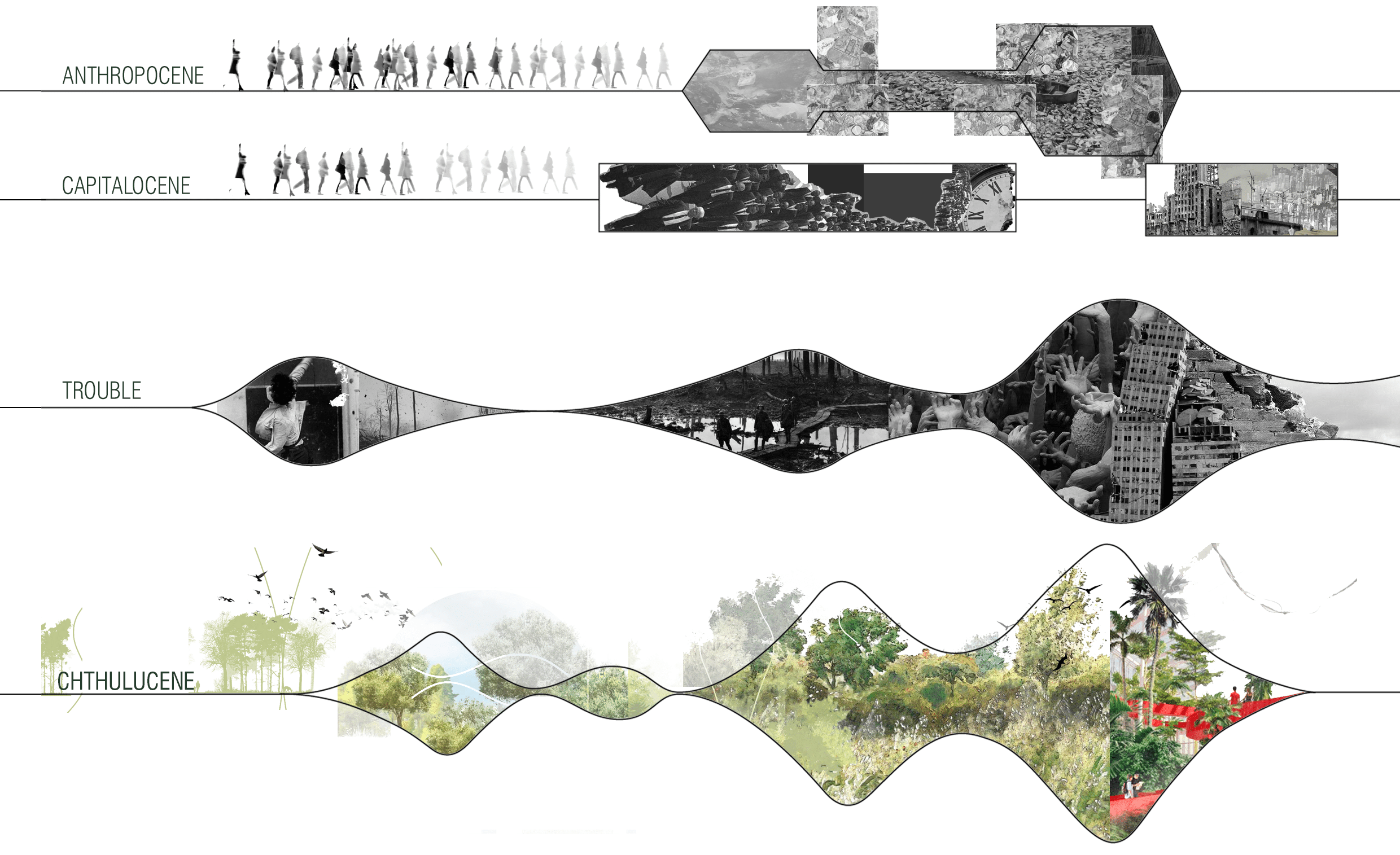
Our vision of the future is inspired by Donna Haraway’s Staying with the Trouble, which proposes a shift from the Anthropocene to the Chthulucene, a radical change where humans move away from domination and toward more inclusive, interconnected, and ecologically responsible ways of living, landing the proposal in 2075.
Problem Analysis
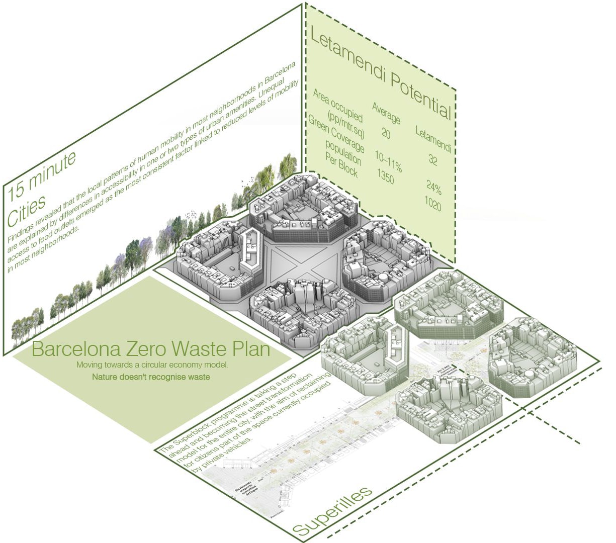
Problem Analysis: We begin with density. Barcelona is a dense city by design, and in itself, density was never the problem as it was the foundation of Cerdà’s Eixample. The problem is density increasing without balance.
Today, Barcelona faces a housing crisis driven by high demand and limited supply. Population growth, tourism, and global investment have intensified pressure on a housing stock. This imbalance has led to the intensification of existing blocks.
Under this pressure, space has been increasingly privatized. Inner courtyards, originally conceived as permeable green spaces, were built over and paved.

As a result, the ground became sealed and impermeable. This has critical ecological consequences. Impermeability disrupts soil life, and eliminates the conditions for biodiversity to survive. Pollinators, birds, and other species are gradually pushed out of the urban fabric as human activity occupies every available surface.
These processes are co dependent, for housing crisis intensifies density; density accelerates privatization; privatization seals the soil; sealed soil displaces biodiversity. Together, they form a continuous spiral where social, spatial, and ecological pressures reinforce one another.
Understanding this allows us to rethink housing not only as a quantitative problem, but as an ecological one; and to question how density can be transformed into a driver of urban regeneration
Biodiversity Analysis
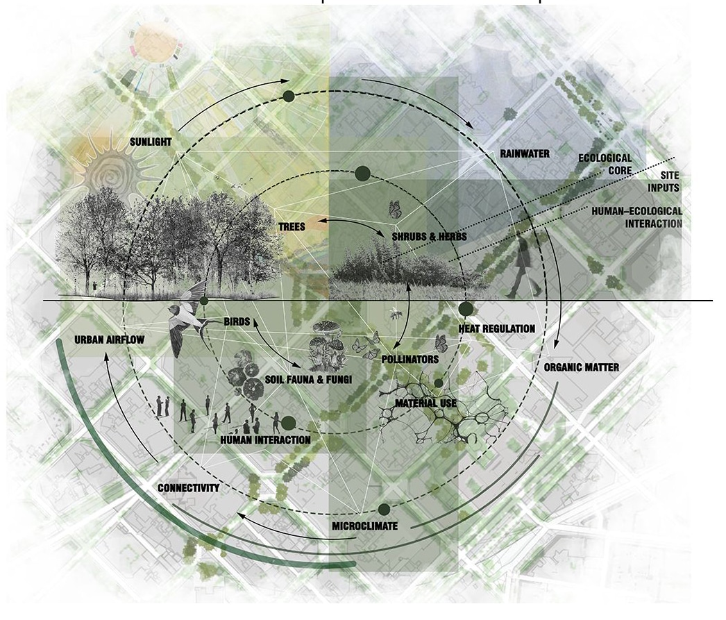

Biodiversity in urban environments depends on the interaction between soil, water, vegetation, climate, and human activity. When these relationships are intact, ecological systems can function even within the city. In Barcelona, however, these connections have been disrupted.
The sealing of the ground prevents water soil regeneration, weakening the ecological base of the city. Without healthy soil, vegetation cannot sustain insects, birds, or microorganisms, and pollinators are among the first species to disappear. As these foundational species decline, biodiversity is progressively displaced from the city.
This analysis frames biodiversity not as an ornamental layer, but as a direct outcome of spatial and infrastructural decisions. By restoring soil permeability and reconnecting water and vegetation networks, urban space can once again support ecological life alongside human activity.
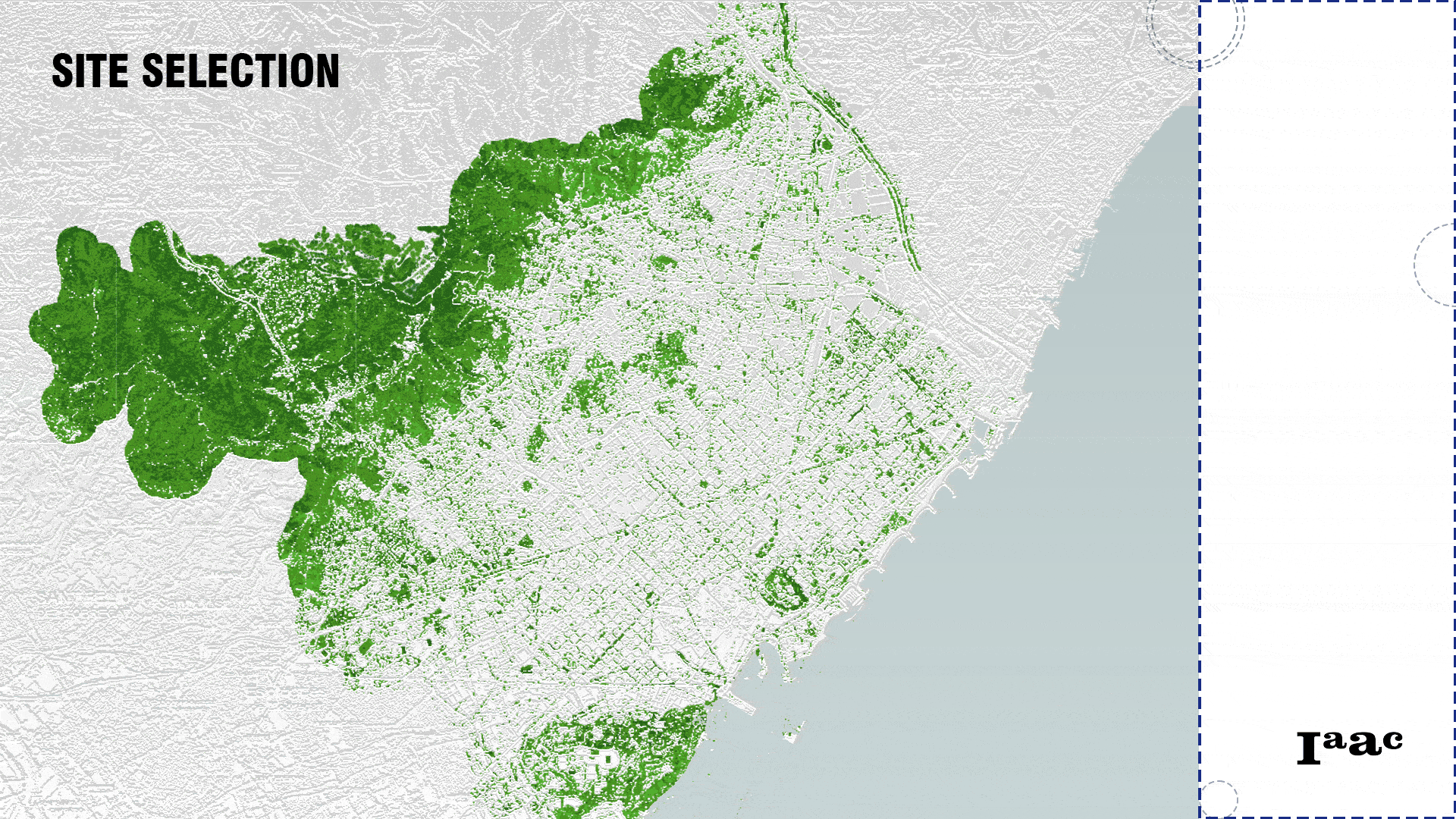
Site Selection
Understanding Biodiversity
Urban biodiversity functions as a network of interdependent species, structured in layers rather than isolated elements. At the base of this system are soil organisms—microorganisms and fungi—which regulate nutrient cycles and enable plant growth.
Above this layer, vegetation operates at different scales: ground cover, shrubs, and trees. Each layer provides microclimatic regulation. These vegetative structures support pollinators and insects, which are essential for plant reproduction and ecosystem productivity.
Pollinators, in turn, sustain higher species such as birds and urban fauna, which contribute to seed dispersal and population control. Together, these species form a continuous ecological chain that depends on water availability, and climatic stability. Fragmented vegetation breaks down this process. When permeability, water cycles, and habitat continuity are restored, humans become part of the ecological loop.
Human Benefit
A zero-waste system is not only an ecological strategy, but a direct human benefit.
There is a way in wich the city reduces its dependence on external resources while improving everyday living conditions.
Benefiting from healthier soil is possible, supporting urban vegetation and pollinators can increases food production, also improving air quality, and mitigating heat island effect; there for directly enhancing urban comfort.
At the same time, local waste and food cycles reduce household expenses and create opportunities for community-based economies. Residents benefit from cleaner environments, lower resource costs, and access to shared productive spaces.
Rather than treating waste as a burden, this system turns it into a productive asset, improving quality of life while strengthening social and environmental resilience within the city
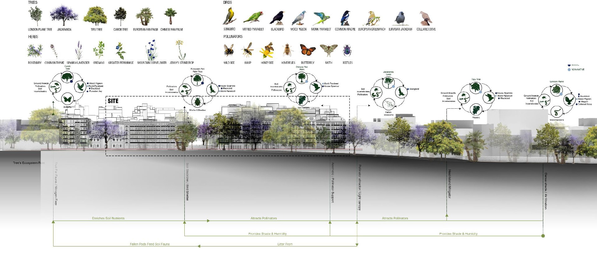
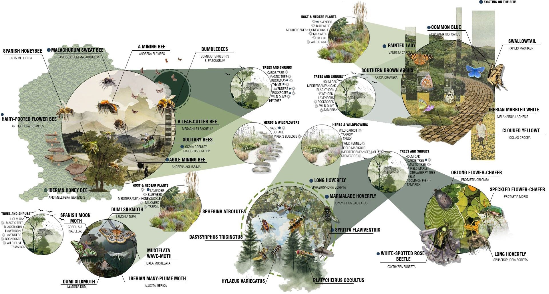
Native Pollination Network
The pollination network is composed of different groups of pollinators, including bees, butterflies, moths, beetles, and flies. Each group interacts with vegetation at different scales, times, and seasons, making biodiversity resilient rather than dependent on a single species.
This project builds on existing pollinators while creating the conditions to attract new ones through native, drought-resistant plants, layered vegetation, and continuous habitats. By restoring soil health, water availability, and connectivity, the site becomes a stable environment where pollinators can thrive and support broader urban biodiversity.
System Analysis
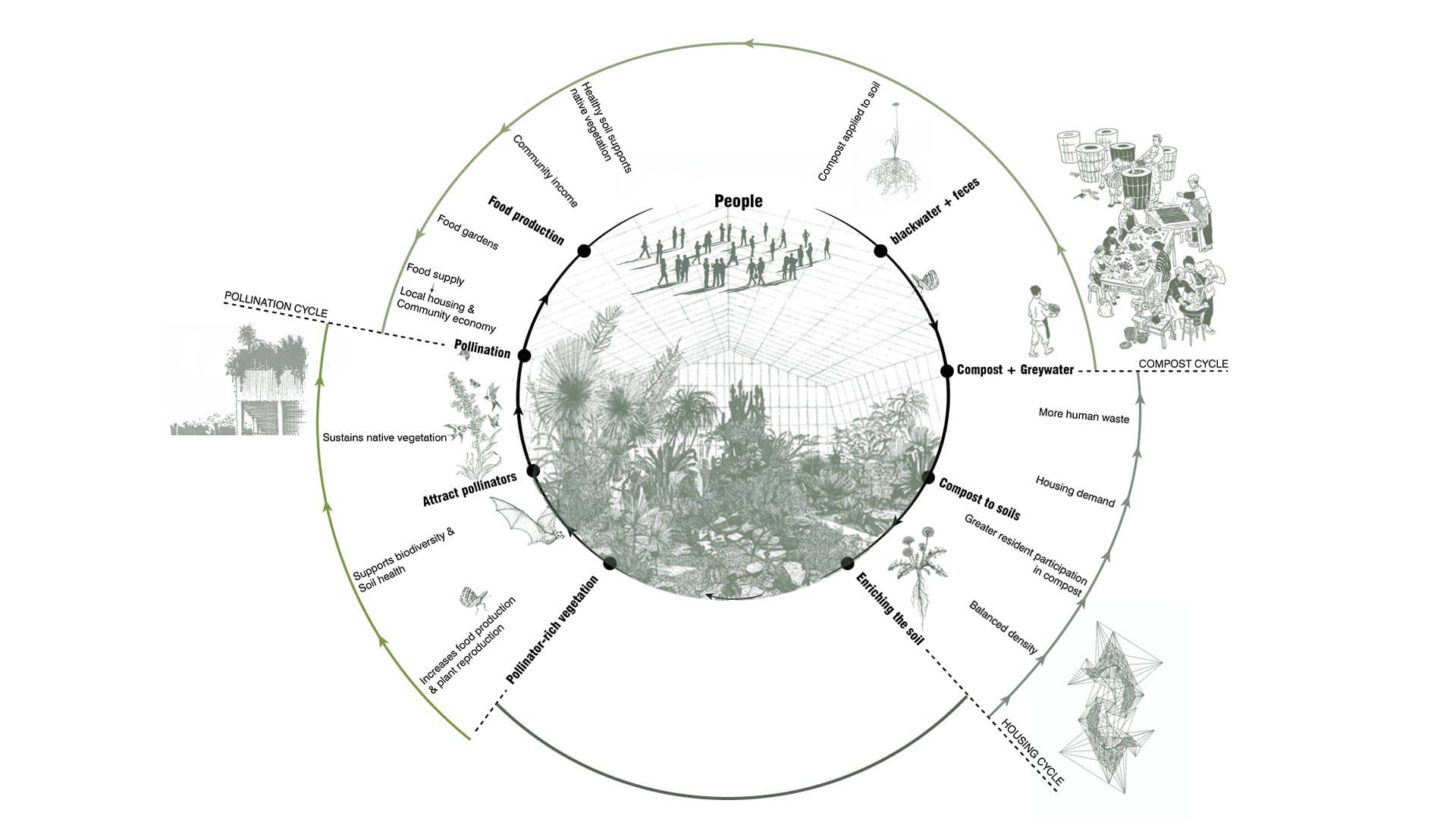
The project operates as a closed-loop system where social, ecological, and infrastructural processes reinforce one another. Human activity generates organic waste and greywater, which are treated and transformed into compost and resources for the soil. Regenerated soil supports vegetation and pollinators, enabling food production and improving environmental conditions. This food and improved habitat directly benefit residents, strengthening local housing and community life.
The system is circular: the more people participate, the more productive and resilient the system becomes, turning density into a resource rather than a problem.
Future of Mobility
Future mobility trends point toward reduced private car use, increased shared mobility, and new logistics systems. As a result, surface streets no longer need to prioritize vehicles at their current scale. Mobility is no longer treated as a barrier, but as an opportunity to restore green space, reduce risk, and reconnect the city at ground level.
Design Strategy
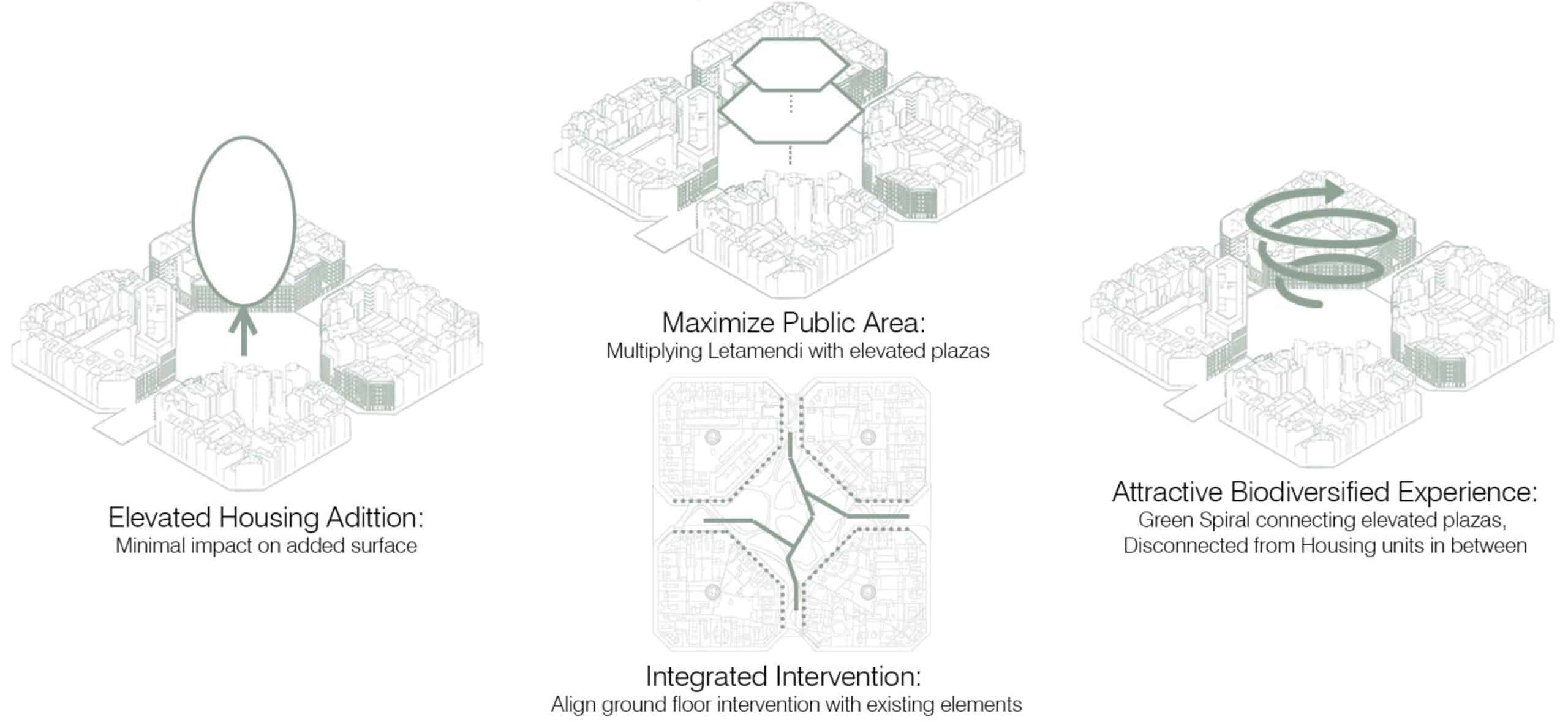

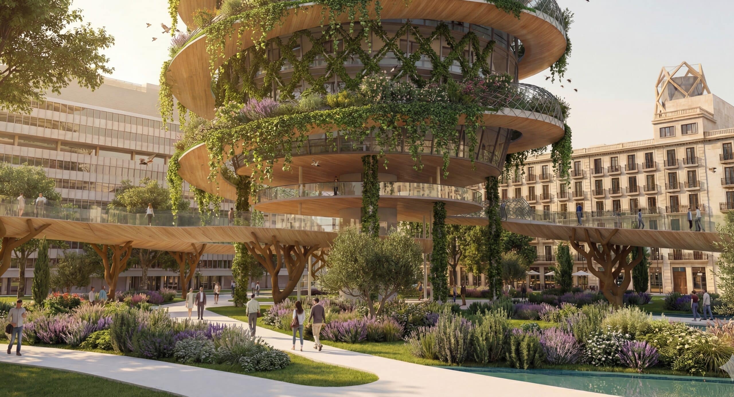
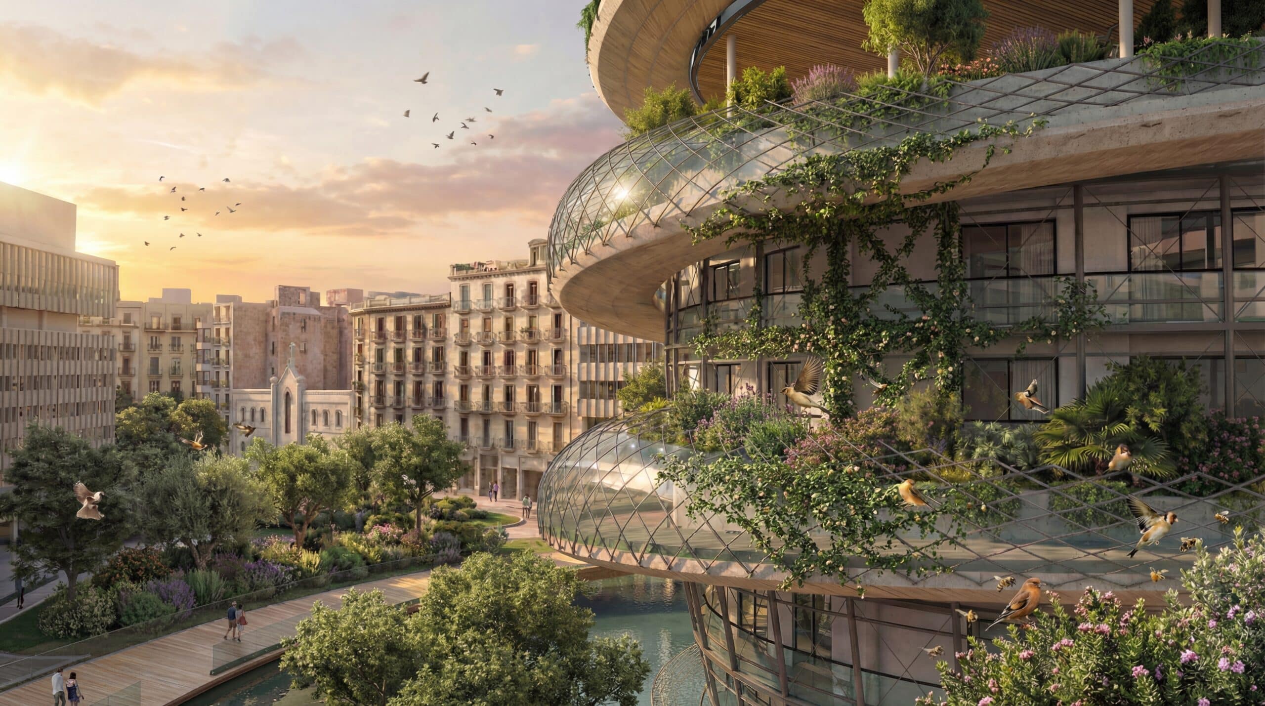
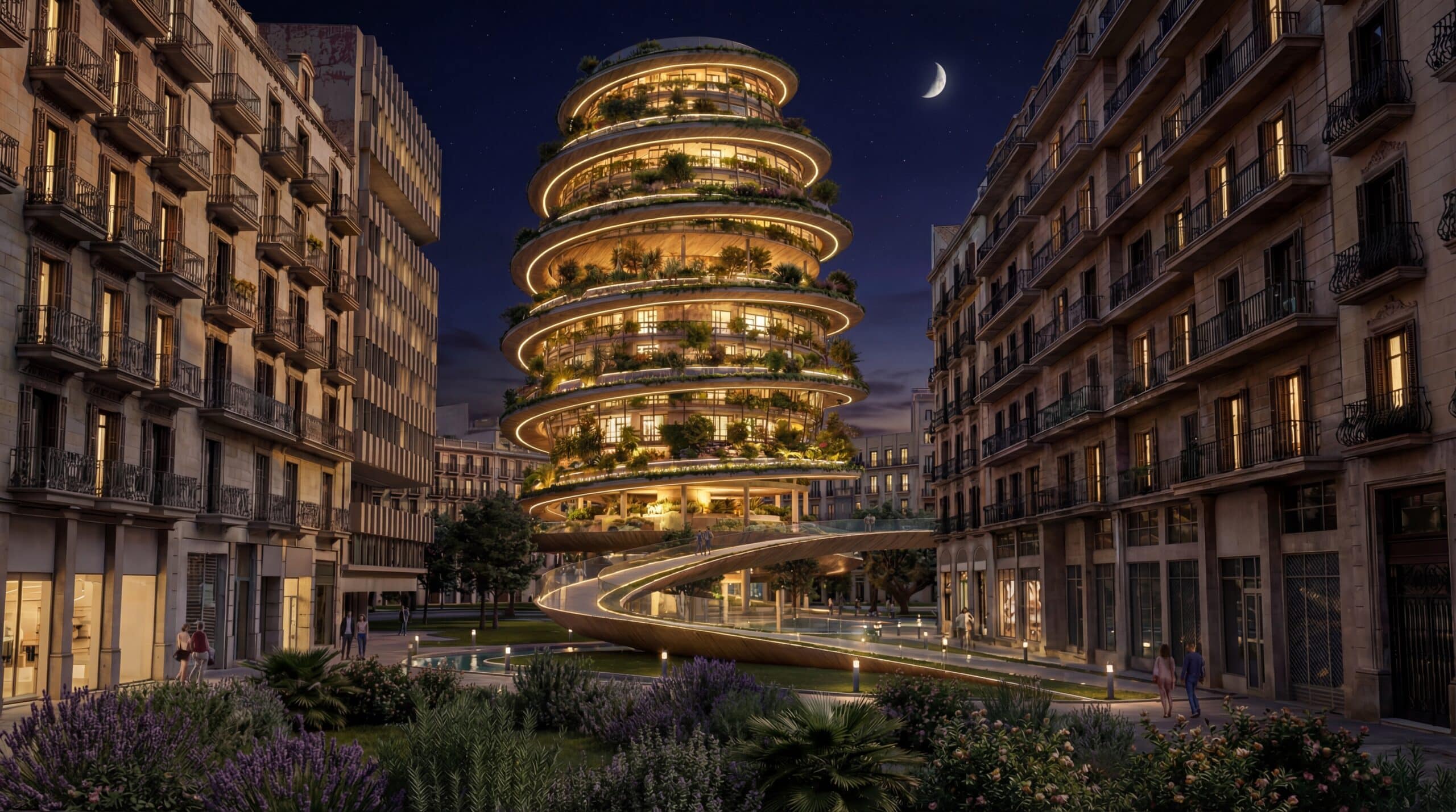
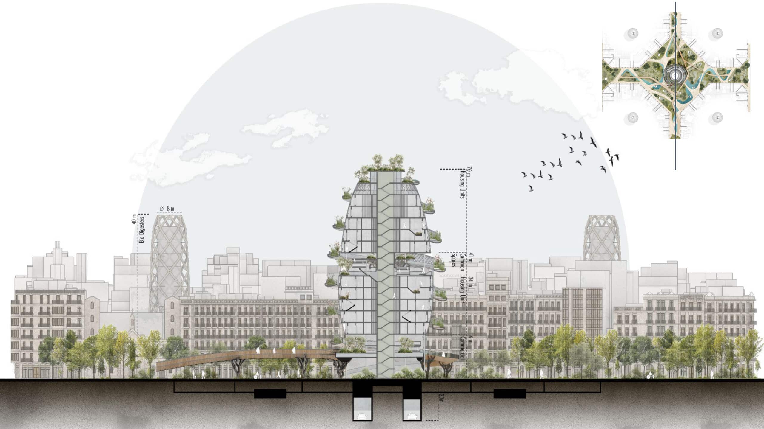
The design strategy is based on a principle of reciprocity: for everything the project takes from the city, it gives something back. Vehicular traffic is diverted underground to return the plaza entirely to public use. New housing is added, but it is elevated, minimizing its footprint and preserving ground permeability.
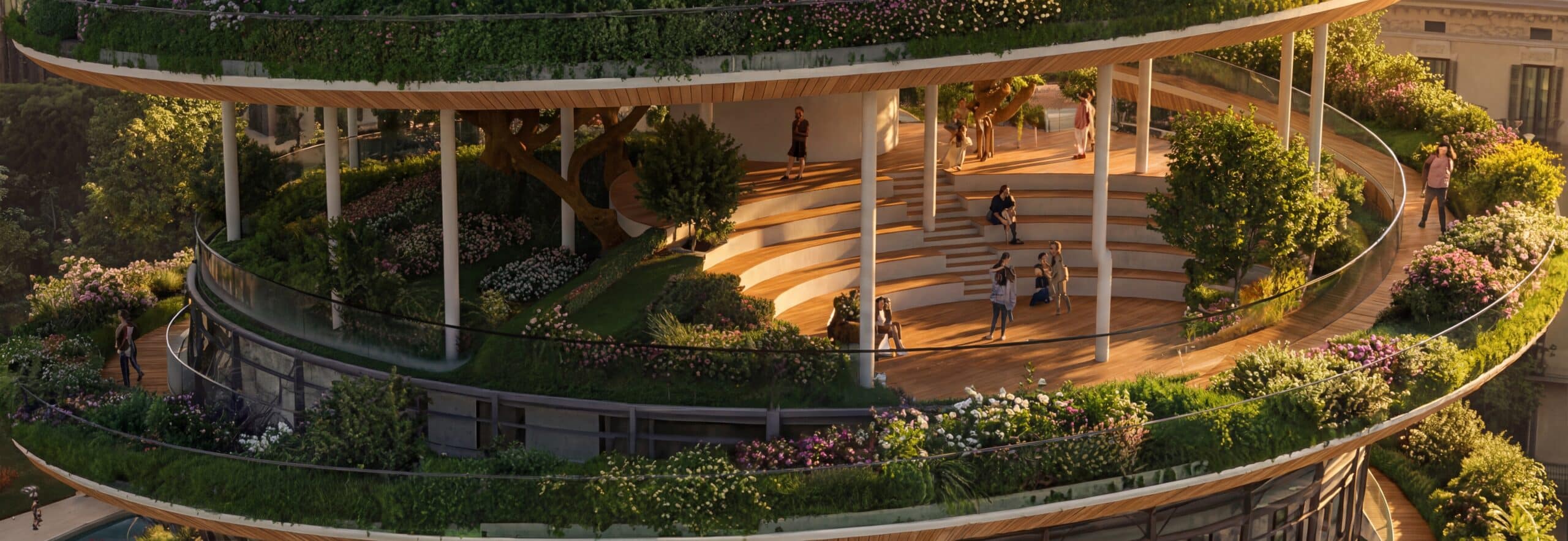
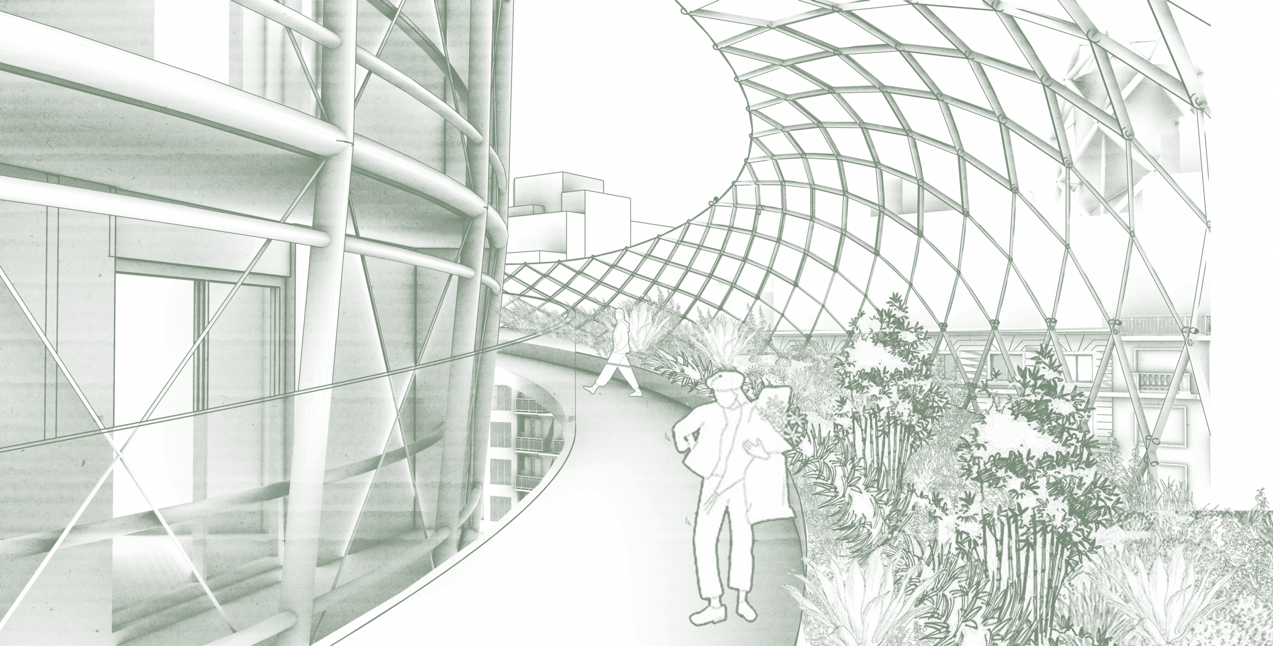
The public space is not only recovered but multiplied through a system of elevated plazas at different levels, extending the square vertically. These plazas are connected by a continuous green spiral that offers an attractive, biodiverse path, fully separated from the housing units to avoid intrusion. Housing maintains its own independent vertical circulation.
Finally, the project respects the existing morphology of the Eixample blocks by aligning the ground intervention with their geometry, allowing the new system to integrate with the city rather than overwrite it
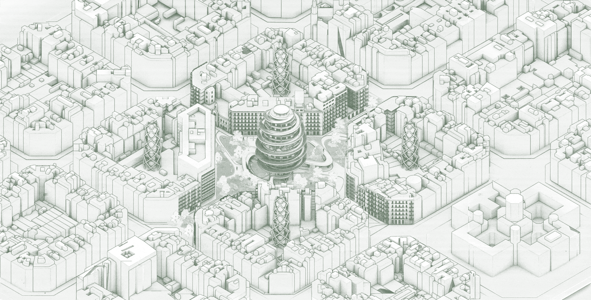
Master Plan Development

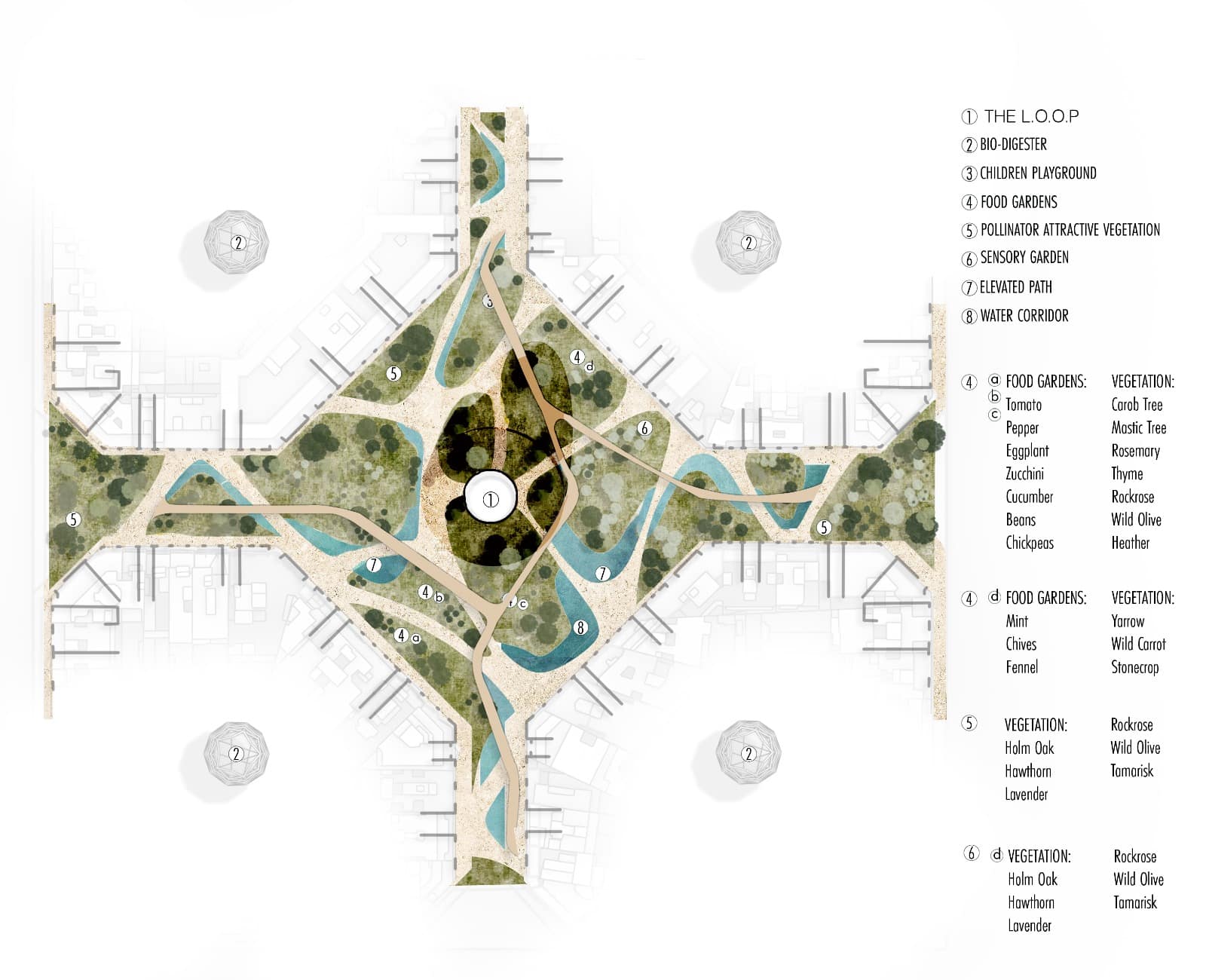
The master plan develops from movement and connectivity. Existing entrance points across the four blocks are identified and connected to form a continuous pedestrian network. These paths converge toward the center, transforming fragmented access into a coherent public system.
Water is then integrated as a connective element, creating a continuous blue corridor that supports soil regeneration and microclimatic regulation. Finally, vegetation and food gardens are layered along these paths, turning circulation into productive ecological infrastructure.
Rather than imposing a new form, the master plan weaves together access, water, and vegetation, allowing the plaza and courtyards to operate as a single connected landscape.
Section
Spatial Impact & Environmental Gain
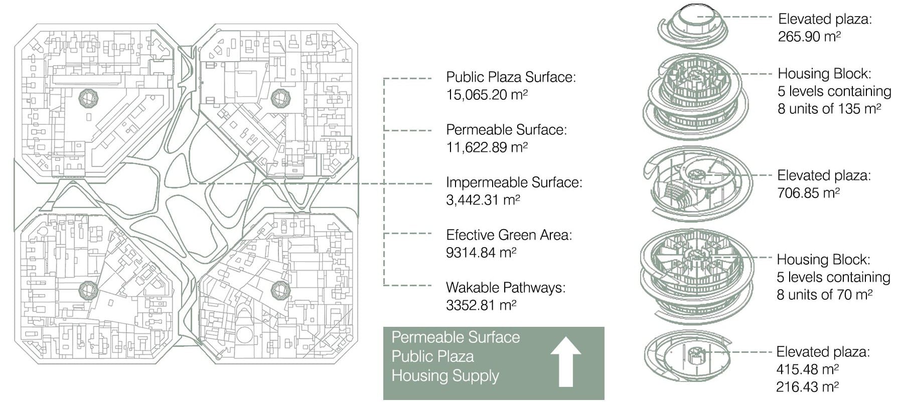
This diagram quantifies how the system translates into spatial, ecological, and social gains. By unsealing the ground and reorganizing circulation, the project significantly increases permeable and effective green surfaces, improving soil health and enabling biodiversity to return to the site.
At the same time, public space is not only preserved but expanded. The plaza is recovered at ground level and multiplied vertically through elevated public platforms, increasing accessible public area without consuming more land.
Housing supply is increased through compact, elevated additions, responding to the housing crisis while minimizing impact on the ground. Together, these interventions demonstrate how biodiversity, soil regeneration, housing provision, and public space can be improved simultaneously through a single integrated system.
Heat Index Analysis
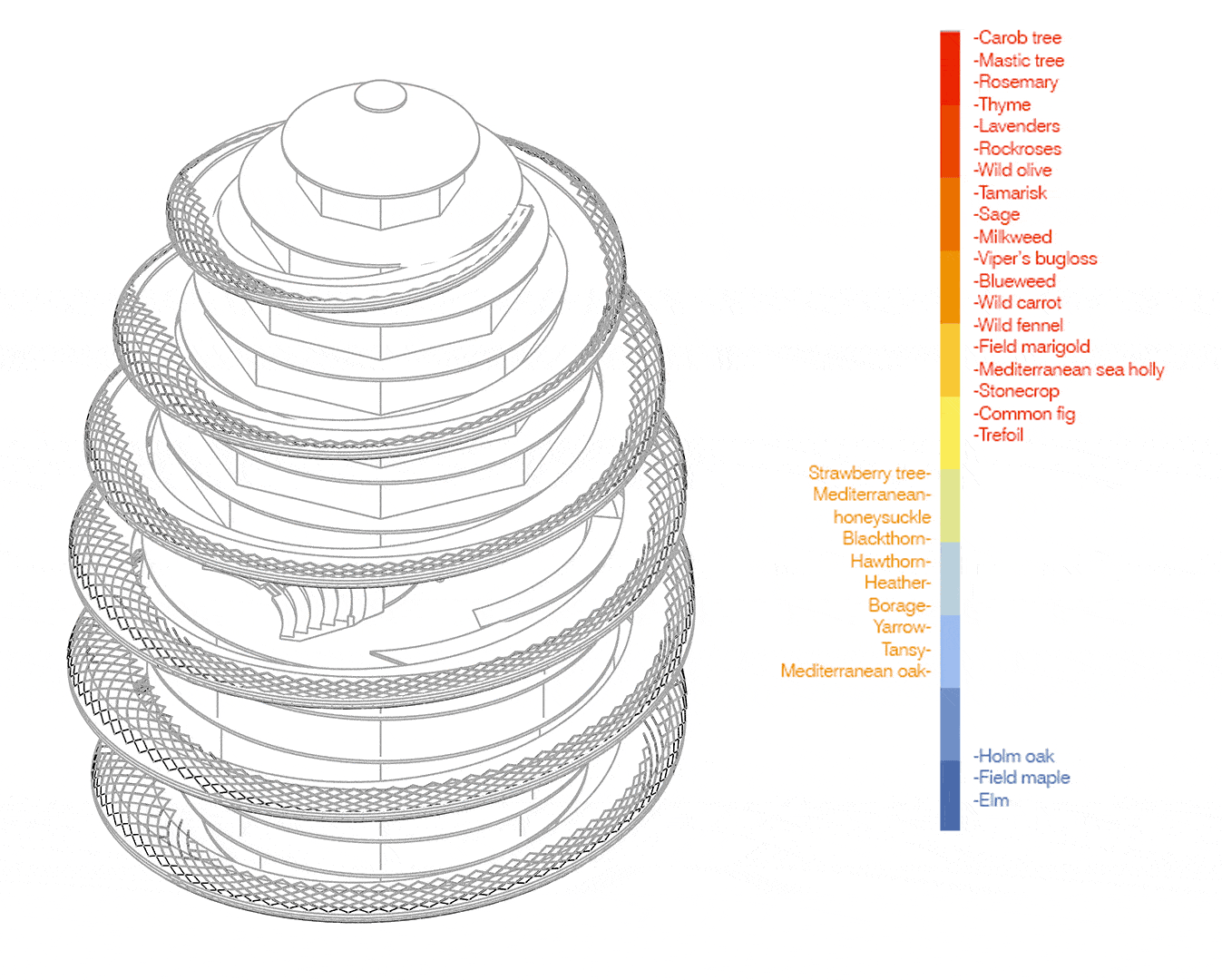
Since we planned to establish greenery on the façades, ramp and floor plates, we ran sun analysis to guide the placement of different species. The species list on the right is grouped by sun exposure needs (high / medium / and low exposures).
Project Key Elements
In this axonometric view, we are highlighting the project’s key components: elevated housing, multi-level public plazas, a continuous green spiral path, food gardens, bio-digestion infrastructure, and underground traffic, all integrated within the Eixample block system.
System Diagram
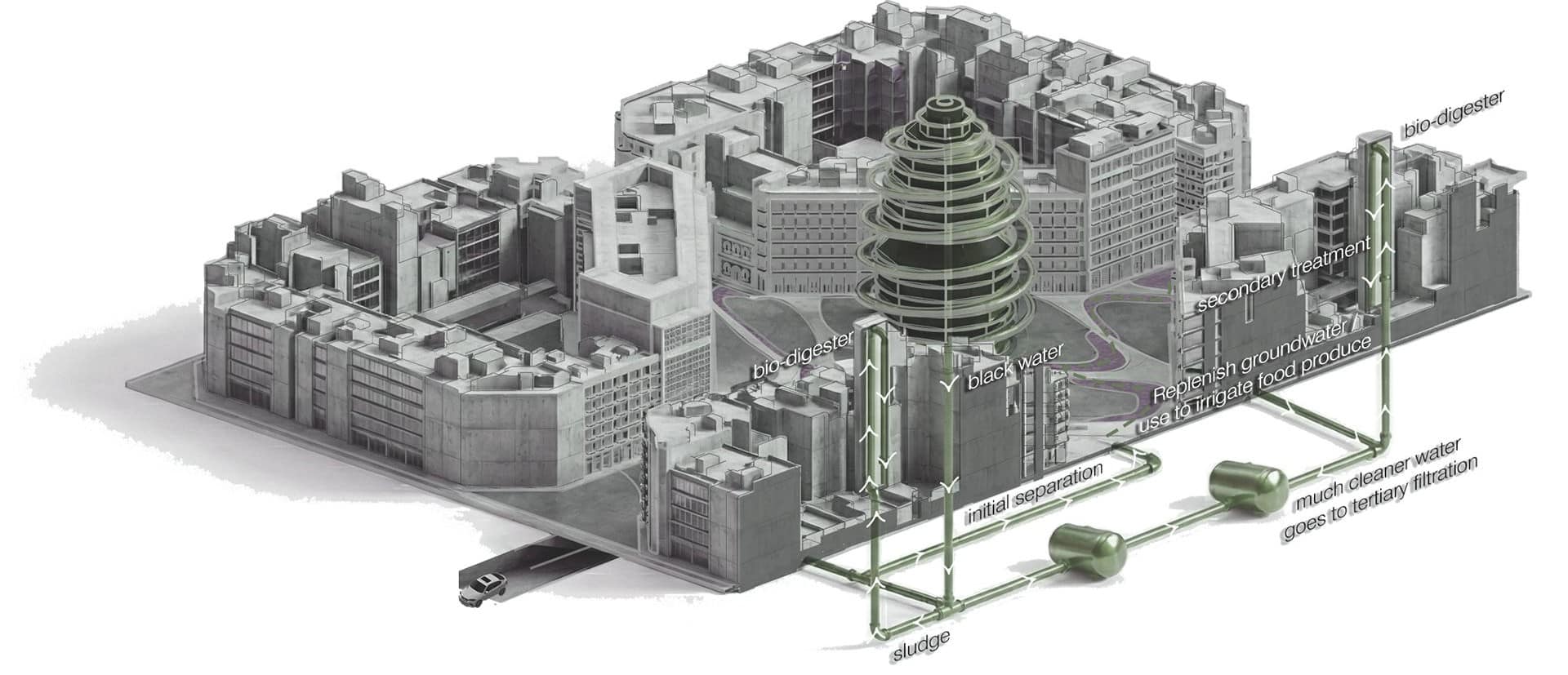
System diagram illustrating the bio-digester network, located within the inner courtyards of the blocks and connected through an underground infrastructure. Organic waste and blackwater are collected, separated, and treated on-site, producing compost and treated water that are redistributed back to the soil and food systems. The diagram emphasizes how decentralized bio-digesters operate as a hidden layer, linking housing, courtyards, and public space into a single circular system.
Facade System & Materials
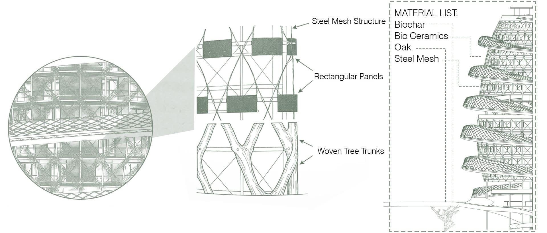
Facade system diagram illustrating a layered envelope that provides privacy through a permeable, vegetated filter. The system combines steel mesh, bio-ceramics, wood, and woven natural elements to mediate light, air, and views, creating a breathable facade that protects interior spaces while maintaining a strong connection to nature.
Schematic Views
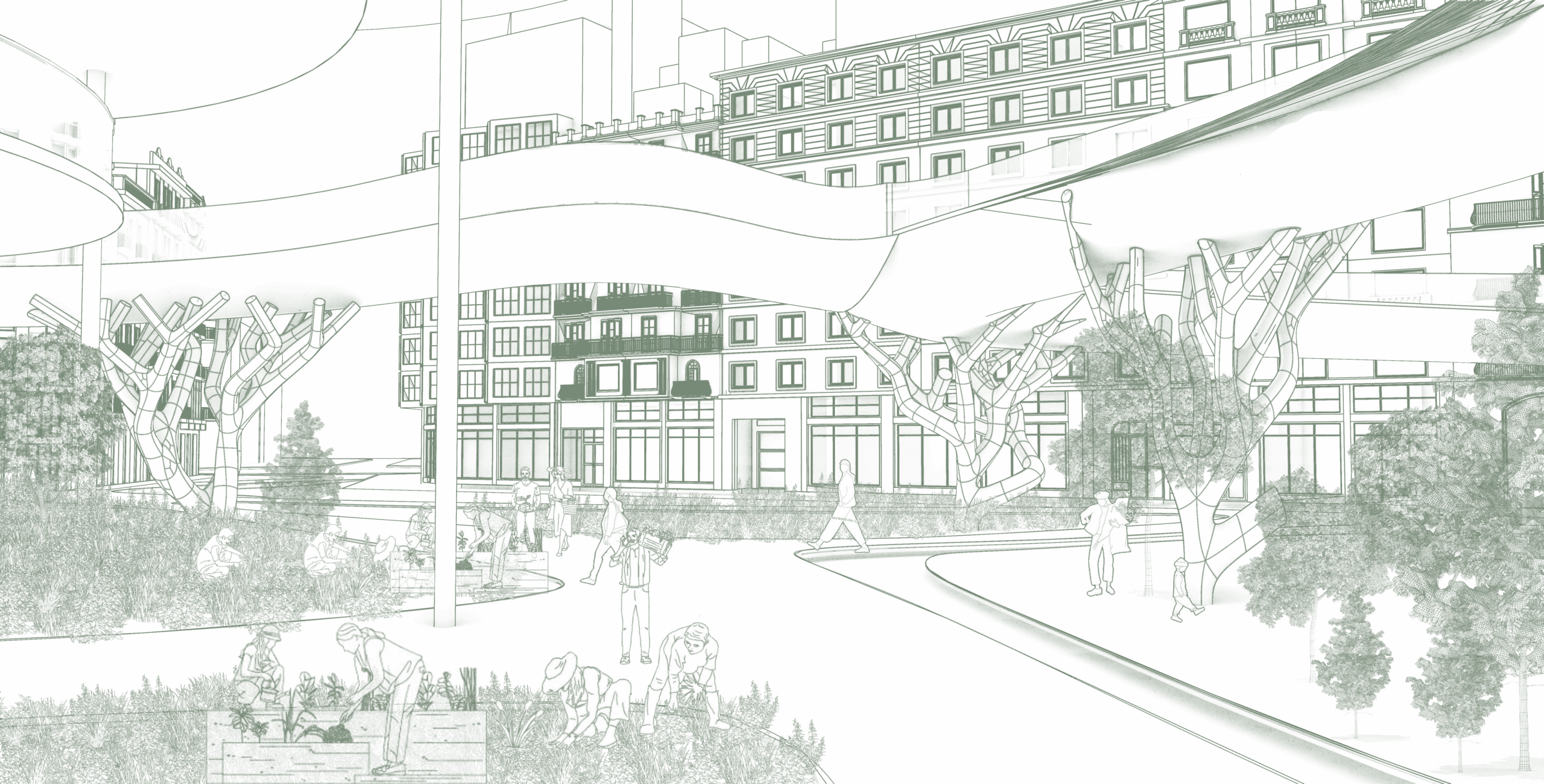
Renders