
Parco de mä was developed by Matteo Piccoloto, Yohan Wadia, Amélie Roy, Lisa Guglielmi, Pushkar Runwal, Koen Kool, Juan Felipe Casses, Dimitris Athanasiou, with the support of trainers from the Vienna University of Economics and Business, the Institute for Advanced Architecture of Catalonia, the University of Genoa and ALDA, during the Green Skills for Cities project, co-funded by the Erasmus+ programme of the European Union.
INTRODUCTION
Genoa, the capital of Liguria and a historical port city in northern Italy, is one of the most remarkable and picturesque cities in Europe. Nestled between the Ligurian mountains and the azure blue sea, Genoa boasts a unique and captivating blend of natural beauty and cultural richness.
With a history dating back to ancient times, Genoa’s strategic location on the Mediterranean coast made it a prosperous centre of trade and commerce. During the Middle Ages, the city became one of the most influential trading powers in Europe, and its wealth and influence extended beyond its borders. Genoa’s historical legacy is evident in its many examples of mediaeval, Renaissance, Baroque, and Gothic architecture, which can be seen throughout the city’s winding streets and picturesque piazzas.
Despite its rich history, Genoa’s fortunes declined in the modern era, and the city faced a series of challenges including economic decline and urban decay. However, in recent years, the city has undergone a transformation, revitalizing its historical landmarks and cultural offerings, and embracing new technologies and innovations to promote growth and development.

Fig. 1. Aerial view of Genoa city.
Genoa faces challenges against planetary emergencies such as climate change and natural disasters. The two major issues that Genoa has faced over the past decades are the fluvial flooding of the Bisagno river and a drastic rise in the urban heat island effect in the city due to heavy concentration of built environment. From 2010 to 2021, 21 extreme weather events have occurred in Genoa, including severe flooding that devastated parts of the city and disrupted rail and road infrastructure. The triggering cause of these events are often heavy rainfall that occurs in a short amount of time causing the subsequent overflow of the Bisagno stream and other waterways involved.
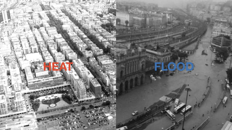
Fig. 2. Major urban concerns of the city of Genoa.
SITE ANALYSIS
Foce, a neighborhood in Genoa, Italy, is a vibrant and diverse area with a rich history and a range of attractions. Located near the sea, it offers picturesque views and easy access to the waterfront. Foce is characterized by its lively atmosphere, with regular cultural events, art exhibitions, and live performances taking place in the area. The neighborhood’s architecture reflects its history, featuring a mix of traditional buildings and modern structures. The river Bisagno passes through Foce below SS1 highway before merging in the Liguarian sea.
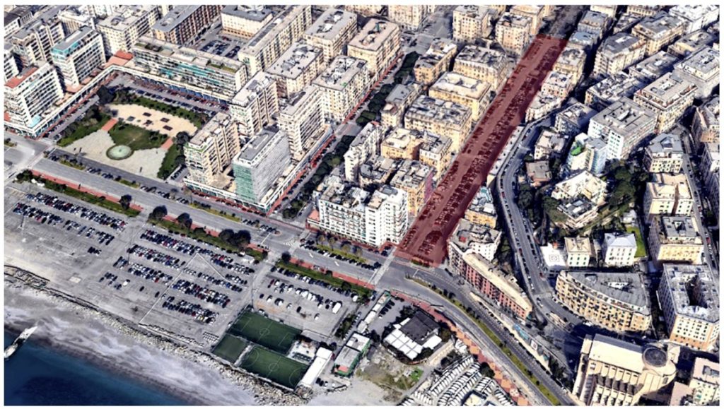
Fig. 3. A city map of Genoa.
Located between the Foce and Albaro neighbourhoods, via Casaregis occupies a site that reflects the contrasting characteristics of its surroundings. Despite residential buildings lining both sides of the street, the area suffers from a dearth of commercial establishments and a lack of vibrant leisure activities. Moreover, the site is devoid of vegetation, with a noticeable absence of trees along the street and walkways. However, the site encompasses 320 car parks, 150 motor parks, and 6 waste bin locations. These parking facilities serve the needs of local residents as well as visitors who come to enjoy the nearby seafront area.
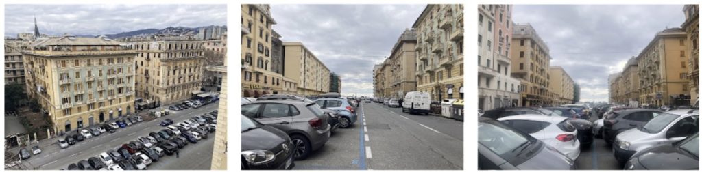
Fig. 4. Site images of Via Casaregis
The context surrounding the site is primarily residential, with retail spaces at the street level and a few commercial buildings scattered around. Additionally, there are several places of worship in the vicinity. Vegetation is predominantly found in the Albaro neighbourhood, mostly in the form of private green spaces. There is a notable disparity in the availability of green areas between Foce and Albaro, which can be attributed to the correlation between income levels and property prices in the respective neighbourhoods.
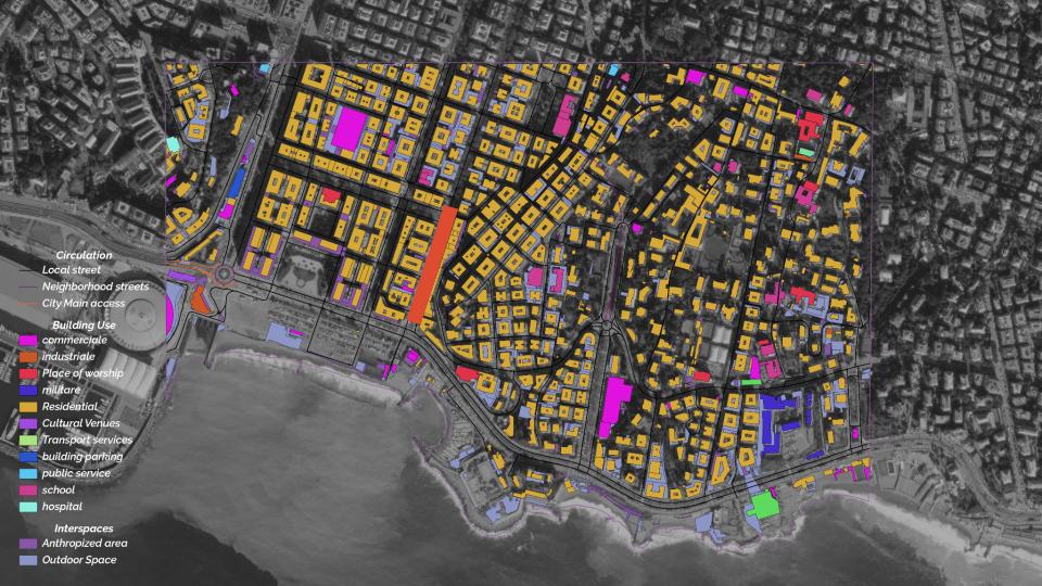
Fig. 5. Land Use pattern around via Casaregis
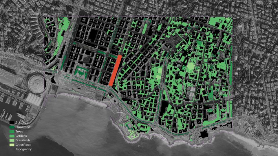
Fig. 6. Ecological Assets around via Casaregis
The area surrounding the site exhibits a high ratio of built to unbuilt spaces, leading to a pronounced urban heat island (UHI) effect. A noticeable contrast is observed when comparing the Foce and Albaro neighbourhoods, primarily due to the discrepancy in vegetation. This suggests that introducing additional greenery could help mitigate the UHI stress. In terms of water management risk, the area is predominantly impermeable, raising concerns about fluvial flooding from the Bisagno River that runs beneath the S22 in Foce. Furthermore, the coastline faces a significant threat from rising sea levels. These factors highlight the importance of addressing water-related challenges in the vicinity. Implementing measures to enhance permeability and flood resilience, such as creating green spaces and improving drainage systems, can contribute to better managing these risks.
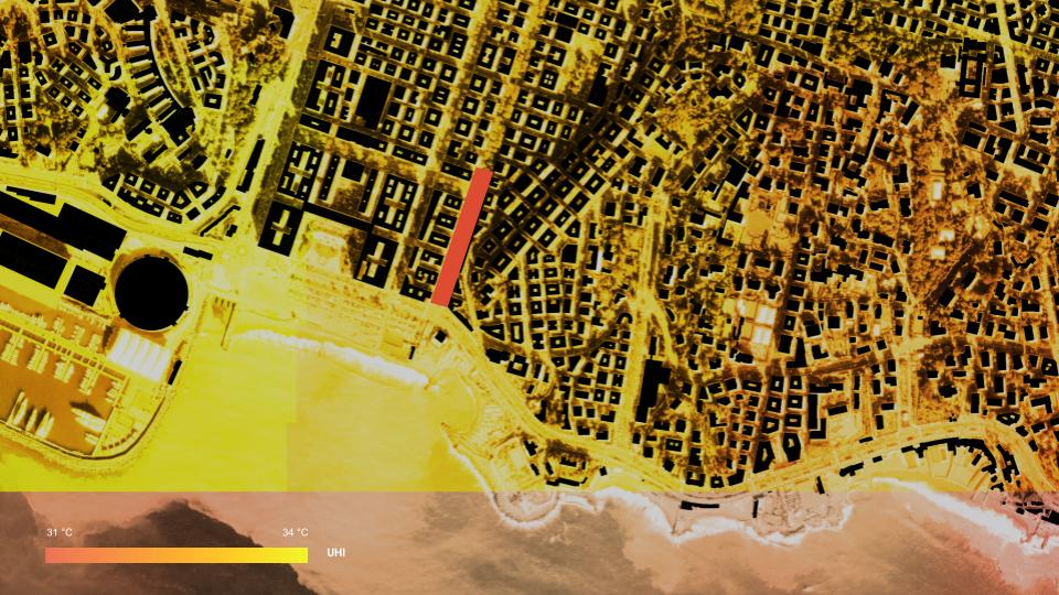
Fig. 7. Urban heat island effect around via Casaregis
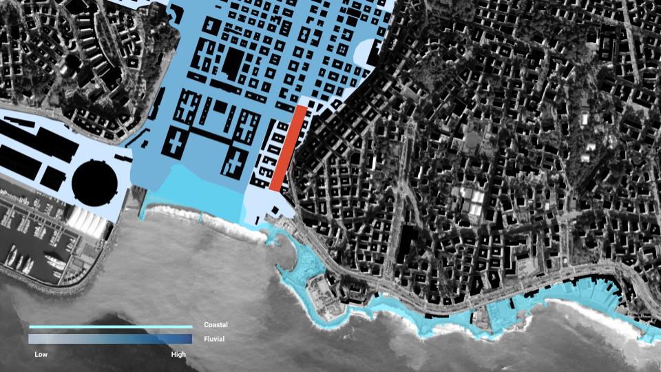
Fig. 8. Flooding risk around via Casaregis
PROPOSAL
The main design intent is to give back space to the community living in and using the area. The design is based on the goal to increase health and well being and mitigating heat. Therefore reducing car dependency plays a major role. Furthermore, the design aims to include people by creating a sense of community, promoting inclusiveness and generating a wider user base for local retail.
4a. Design objectives.
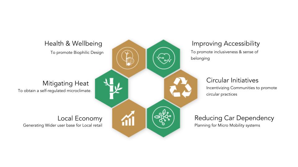
Fig. 9. Design Objectives
- Improving Health and Well-being:
Enhance the physical and mental health of residents by prioritising pedestrian-friendly infrastructure, creating green spaces, and promoting active transportation options like cycling and walking. Incorporate elements that encourage social interaction and community engagement.
- Improving Accessibility:
Develop a well-connected and inclusive environment by improving public transportation networks, enhancing pedestrian and cycling infrastructure, and ensuring barrier-free access for people with disabilities. Promote seamless connectivity within the neighbourhood and with surrounding areas.
- Circular Initiatives:
Implement sustainable practices that minimise waste and resource consumption. Incorporate circular economy principles by integrating recycling systems, promoting reuse and repurposing of materials, and incorporating renewable energy sources. Foster a closed-loop system within the neighbourhood.
- Reducing Car Dependency:
Create a shift toward sustainable transportation modes by prioritising public transit, pedestrian infrastructure, and cycling networks. Promote car-sharing services and electric vehicle charging stations. Implement traffic calming measures to reduce car speed and create a safer environment for non-motorized transport.
- Boosting Local Economy:
Support local businesses and stimulate economic growth by creating vibrant public spaces and commercial opportunities. Foster a diverse mix of retail, restaurants, and services to attract both residents and visitors. Encourage entrepreneurship and collaboration among local businesses.
- Mitigating Heat with Nature-Based Solutions:
Integrate nature-based solutions to combat the urban heat island effect. Increase greenery by planting trees, creating green roofs, and implementing vertical gardens. Enhance natural shading and cooling through landscaping and water features. Prioritize permeable surfaces to manage stormwater runoff and reduce flood risk.
DESIGN STRATERGIS
The principles of tactical urbanism and participatory urbanism are pivotal in realizing the objectives delineated earlier for the site via Casaregis. Tactical urbanism entails the implementation of temporary or small-scale interventions aimed at promptly improving the urban environment. Within the context of the design objectives, tactical urbanism serves as a means to swiftly test and assess diverse strategies and ideas before committing to extensive and permanent modifications. It facilitates flexibility, adaptability, and valuable insights gleaned from the outcomes of these interventions. For instance, temporary installations of street furniture, pop-up parks, or bike lanes can be deployed to evaluate their impact on health, accessibility, and the reduction of car dependency. Feedback garnered through tactical urbanism can effectively inform subsequent design decisions, providing invaluable insights into the most efficacious approaches.
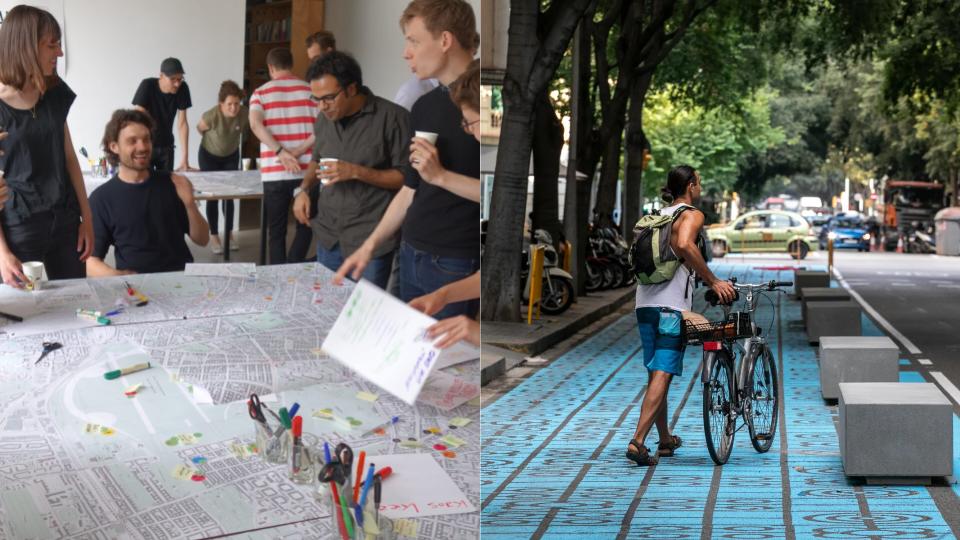
Fig. 10. Use case of Participatory and Tactical urbanism.
Participatory urbanism places paramount importance on the active engagement of local residents, businesses, and stakeholders in the urban design process. It acknowledges the invaluable knowledge, experiences, and aspirations held by these constituents regarding their neighbourhood. In the case of via Casaregis, fostering community involvement through participatory methods such as workshops, charrettes, and public consultations ensures that their voices are heard and their needs are effectively accounted for. This participatory approach fosters a sense of ownership, bolsters community cohesion, and augments the prospects for successful implementation and long-term sustainability of the proposed design interventions. The input and ideas shared by participants significantly contribute to refining the design objectives and shaping the ultimate outcome in a manner that authentically reflects the distinct character and aspirations of the community.
By effectively amalgamating tactical urbanism and participatory urbanism, the design process acquires a dynamic, responsive, and inclusive character. It enables iterative enhancements, empowers the local community, and significantly enhances the likelihood of achieving the desired objectives pertaining to improving health and wellbeing, enhancing accessibility, fostering circular initiatives, reducing car dependency, stimulating the local economy, and mitigating heat through nature-based solutions.

Fig. 11. Vision for Via Casaregis
MASTERPLAN
A tactical urbanism approach can be employed to allocate approximately 20 percent of the existing parking space within the area for the creation of versatile and multi-use recreational activity spaces. This strategic intervention aims to gradually challenge the prevailing habit of residents parking their cars in this specific zone. By repurposing a portion of the parking area, the intention is to visually and tangibly demonstrate to the community the potential of public spaces as valuable assets for their personal enjoyment, rather than solely as car storage. This innovative tactic serves as a catalyst for shifting mindsets and fostering a sense of ownership and engagement with the communal environment. As residents witness the transformation of formerly underutilised spaces into vibrant recreational hubs, they are more likely to be inspired and motivated to explore alternative means of transportation and to embrace the myriad opportunities presented by the newly repurposed areas. Through this tactical urbanism endeavour, the community is encouraged to re-envision the use of public spaces, embracing a paradigm shift that emphasises the cultivation of a vibrant, people-centred neighbourhood.
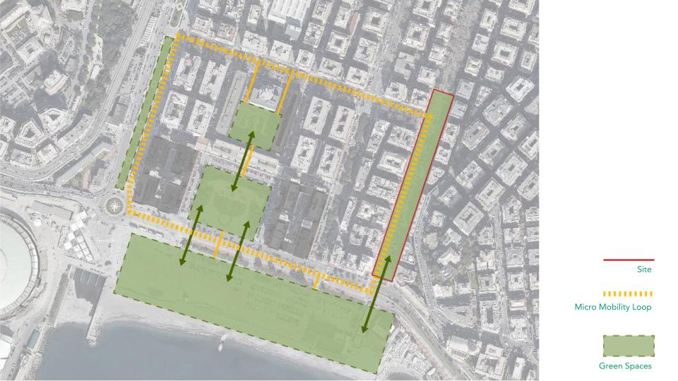
Fig. 12. Proposed Master plan for Via Casaregis.
The second phase of the project entails a comprehensive transformation of the central street parking into an enchanting urban forest and park, designed to serve as an idyllic oasis amidst the urban fabric. This visionary undertaking aims to create an expansive green space that not only mitigates the urban heat island effect but also fosters a deep connection between the community and nature. By replacing the conventional streetscape with lush vegetation, tranquil walkways, and inviting recreational amenities, the project seeks to offer an immersive experience where residents can unwind, engage in physical activities, and cultivate a profound appreciation for the natural world.
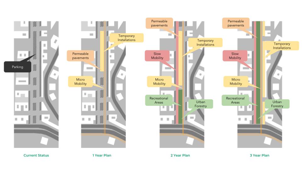
Fig. 13. Proposed phase plan for Via Casaregis.
The third phase of the project is centred around an ambitious endeavour that involves reclaiming and reallocating half of the street space to address crucial environmental, social, and economic factors. Through this transformation, various innovative strategies will be implemented to promote sustainability and enhance the overall livability of the neighbourhood.One significant aspect of the third phase involves the integration of permeable pavements. These porous surfaces allow rainwater to infiltrate the ground, reducing stormwater runoff and replenishing groundwater resources. By adopting permeable pavements, the project aims to mitigate flooding risks, enhance water management, and promote ecological balance within the community.
Additionally, the third phase emphasises the promotion of micro-mobility options, such as bike lanes and pedestrian-friendly pathways. By prioritising non-motorized transportation, the project encourages active mobility, reduces car dependency, and improves air quality. This shift towards sustainable transportation modes not only benefits the environment but also fosters a healthier and more vibrant community.
Circular initiatives will also play a pivotal role in the third phase. The project will explore and implement strategies that promote the circular economy, such as waste reduction, recycling programs, and the integration of renewable energy sources. By embracing circularity, the project aims to minimise waste, maximise resource efficiency, and contribute to the local economy.

Fig. 14. Current situation versus the proposal’s plan (view towards north)
The figure shown above highlights the transformation from the current situation to the final one. It can be seen that a great part of the street is given back to the community, with a variety of nature based solutions, a safe bicycle lane and space for pedestrians.
This transformative phase represents a multifaceted approach that addresses pressing environmental challenges while enhancing social well-being and economic opportunities. Through the adoption of permeable pavements, micro-mobility options, circular initiatives, and other innovative measures, the project aims to create a resilient, inclusive, and sustainable neighborhood that sets a benchmark for urban development. By embracing these forward-thinking principles, the community can enjoy enhanced environmental quality, improved mobility options, and a flourishing local economy, solidifying its status as a beacon of innovation and sustainability.
