
INTRODUCTION
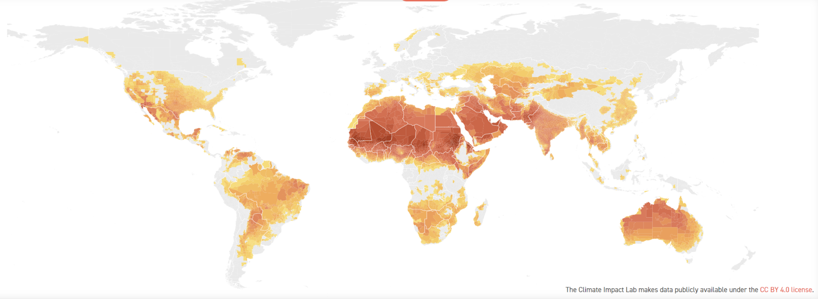
Climate change is an imperative global concern demanding meticulous attention. Its ramifications encompass an array of profound consequences, necessitating urgent action. Rooted in anthropogenic greenhouse gas emissions, this phenomenon engenders a persistent alteration in Earth’s climate patterns, characterized by escalating temperatures, heightened incidence of extreme weather events, and encroaching sea-levels. In this context, comprehending and mitigating the urban heat island (UHI) effect assumes paramount significance.
The Sky View Factor (SVF) emerges as a pivotal parameter within the realm of urban climatology, facilitating a quantifiable assessment of the visible sky fraction from discrete vantage points within urban landscapes. Functioning as a tangible metric denoting the proportion of open sky accessible to an observer, SVF assumes a pivotal role in elucidating and ameliorating the UHI phenomenon. Enhanced SVF values substantiate heightened exposure to unobstructed celestial expanse, thereby facilitating natural ventilation, engendering cooling mechanisms, and fostering efficient heat dissipation. Conversely, locales characterized by diminished SVF, typified by towering edifices and densely-packed urban configurations, suffer from impeded airflow, exacerbating heat retention and accentuating the deleterious impacts of UHI. By incorporating meticulous SVF analysis into the fabric of urban planning and design, cities can effectively optimize building heights, integrate verdant spaces, and orchestrate street layouts to maximize natural ventilation, curtail energy consumption, and alleviate the detrimental consequences of UHI. In effect, leveraging SVF as a robust tool augments sustainable urban development, fostering a climate-resilient paradigm.
SVF METHODS
The determination of Sky View Factor (SVF) involves a variety of methods, each offering distinctive approaches to quantify the proportion of visible sky within urban environments. Here, we explore five prominent techniques utilized to calculate SVF:
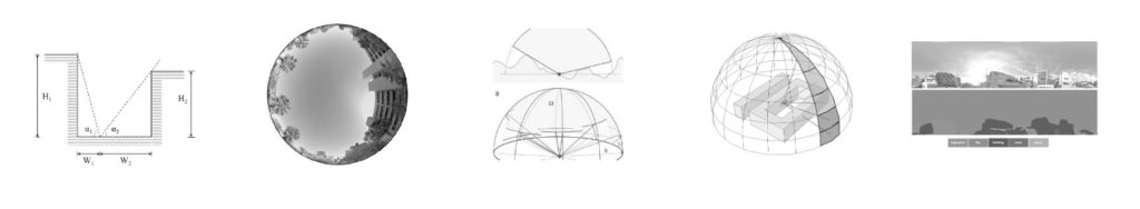
- Geometric Analysis Method: This method employs geometric principles to estimate SVF. It involves analyzing the geometry of a location, considering building heights, and the geometric relationship between the observer and the visible sky. By measuring the vertical angles between the observer and the visible sky, SVF can be determined.
- Fish-eye Photographical Method: This approach employs fish-eye lens photography to capture a full hemisphere view of the sky from a specific location. By analyzing the resulting images, the visible sky fraction can be calculated. This method is particularly useful for assessing SVF in open spaces and parks.
- Global Positioning System (GPS) Method: Using GPS technology, this method involves collecting position data and correlating it with sky obstruction measurements. By analyzing the positional information and comparing it to the visible sky, SVF values can be derived. This technique is effective in areas with a dense concentration of buildings.
- Model-Simulation Method: This approach utilizes computer modeling and simulation techniques to estimate SVF. It involves creating a three-dimensional digital model of an urban area and simulating the movement of solar rays and their interactions with buildings. By analyzing the simulated results, SVF can be calculated accurately.
- Street View Image Method: This method relies on street-level imagery obtained from sources such as Google Street View. It involves analyzing images to identify visible sky portions and calculate SVF. This technique provides a convenient and cost-effective way to estimate SVF for large-scale urban areas.
PROBLEM STATEMENT – SOLUTION- USE CASE
Statement – Sky View Factor is a crucial factor for microclimate calculations in a resolution smaller than 100m and currently there are no public repositories for this data.
Solution – A tool that allows the calculation of the Sky View Factor based on open data for any place in the world, democratizing access to data related to climate change.
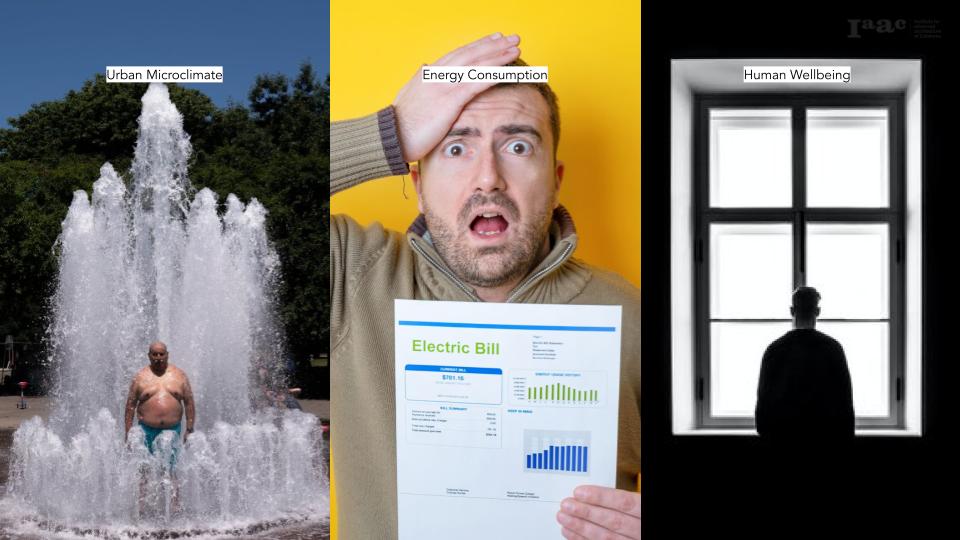
Urban Microclimate: Sky View Factor (SVF) affects the urban microclimate by influencing air circulation and temperature distribution. Higher SVF promotes natural ventilation, reducing heat buildup and improving air quality, while low SVF areas experience stagnant air and higher temperatures, exacerbating the urban heat island effect.
Energy Consumption: SVF plays a crucial role in energy consumption within urban areas. Higher SVF values allow for increased natural lighting, reducing the need for artificial lighting during the day. Additionally, improved natural ventilation in high SVF areas can lower the reliance on mechanical cooling systems, leading to energy savings.
Human Wellbeing: SVF impacts human wellbeing in urban settings. Higher SVF promotes access to open sky and sunlight, contributing to psychological well-being, mood enhancement, and vitamin D synthesis. It also facilitates the creation of pleasant and comfortable urban spaces, encouraging outdoor activities and social interactions, fostering a sense of community.
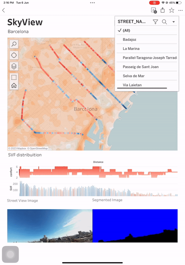
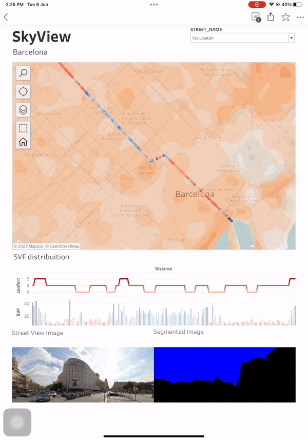
In terms of this project we work on urban microclimate in Barcelona using the heat stress data of Barcelona from the open data Barcelona portal. And in terms of SVF we have used locations at intervals of twenty meters of six different streets of Barcelona to examine the relationship between the heat stress and the SVF.
METHOD
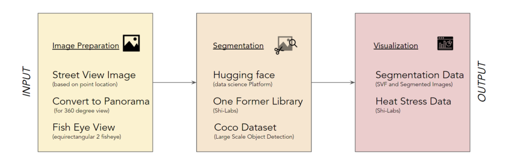
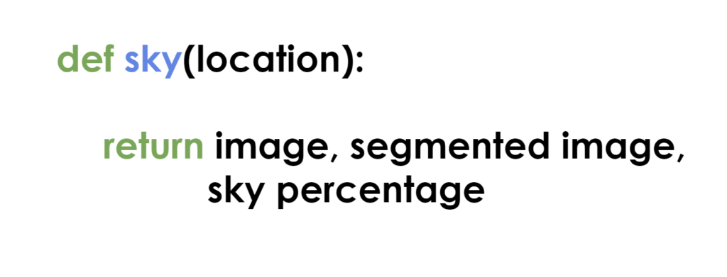
To calculate the SVF based on the google street view imagery we used the methodology mentioned in the diagram. We built a def function that on inputting the coordinates of the location returns the the original panoramic image from google street view, segmented image with sky marked and the sky percentage at the given location.
OUTPUT
Using tableau for visualization of the dashboard, we created an interactive dashboard that allows the user to examine the relationship between the heat stress and sky view factor at a given locations for six major streets of Barcelona.
FUTURE STEPS
The future steps of the SVF (Sky View Factor) calculation project based on Google Street View imagery involve several key aspects. First, there is a need to refine the algorithms used to extract accurate vegetation factors from the imagery. This includes differentiating vegetation from other elements and accounting for seasonal changes in vegetation coverage. Additionally, integrating climate data such as temperature, humidity, and precipitation will enhance the understanding of how these factors influence the SVF. In terms of web accessibility is concerned, the idea is to deploy this as a a web app which allows user to mark a location on the map and then returns the output of SVF.
