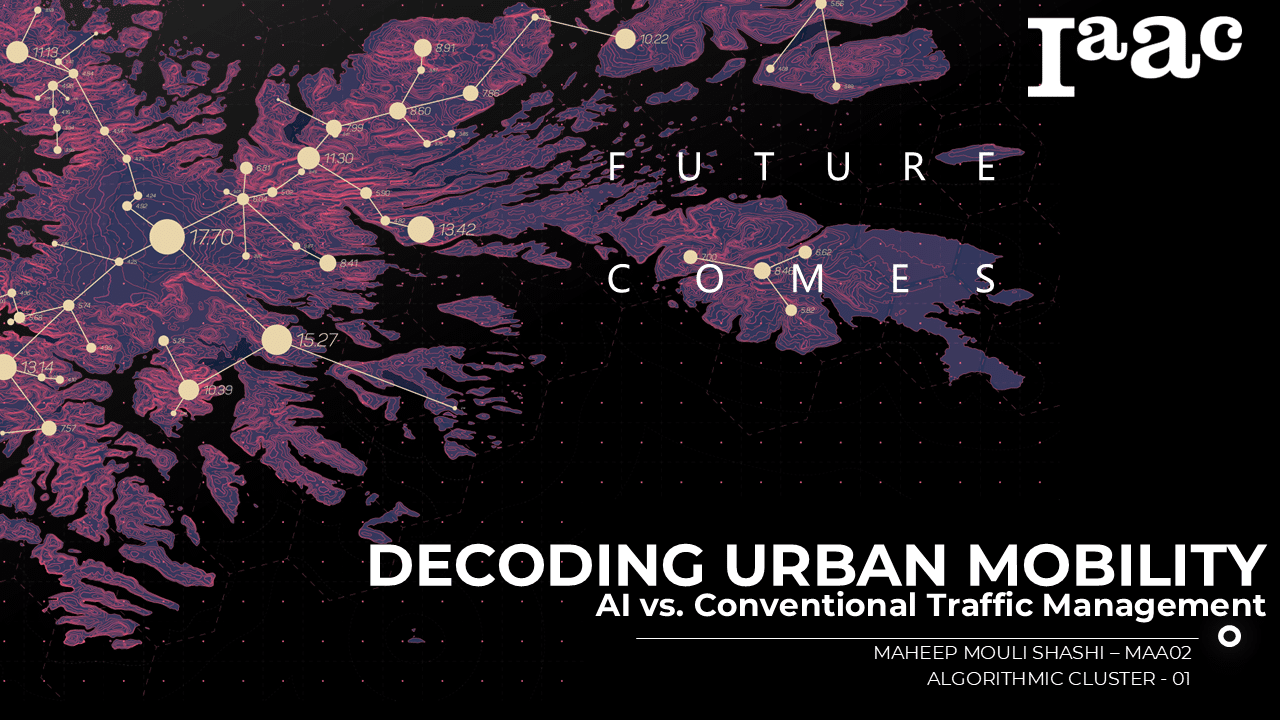
Urban Vegetation Analysis Using Computer Vision and Deep Learning
(PaintDumpster/environmental_data_workshop at ndvi) – Link to GitHub This project aims to detect and classify different types of greenery in satellite imagery by utilizing color and edge detection techniques. The study area is located in Barcelona, Spain (41.396536, 2.194554). The stable version employs color and edge detection for image segmentation, while an alternative method integrates LiDAR … Read more
Urban Layers
Tracking Morphological Evolution Over Time Urbanization and Vegetation Change Analysis Using Satellite Data Introduction Satellite imagery provides a powerful view of Earth’s surface, but to the naked eye, changes like urban growth and vegetation loss are not always obvious over time.Colors and features can look deceptively similar, making it difficult to accurately assess land cover … Read more
Flood Impact Mapping along the Turia River, València – Flood of 2024
When torrential rain dumped an entire year’s worth of water on Valencia in barely eight hours on 29 October 2024, the Turia spilled over its banks, submerging citrus groves, highways and whole neighbourhoods. More than 200 lives were lost, hundreds remained missing and Spain faced its worst flood disaster in recent history. Events like this … Read more
DECODING URBAN MOBILITY
ABSTRACT; Decoding Urban Mobility: This project evaluates the impact of AI-driven traffic management versus conventional fixed-timing methods on urban congestion. It analyzes real-time and historical data—including traffic patterns, weather, demographics, and incident reports—from cities like London, Barcelona, and Los Angeles and compares machine learning models (e.g., LSTM, GRU, XGBoost) with traditional techniques. The study identifies … Read more
Literary Landscapes &AI-Driven Urban Design
A speculative approach to Design through data, literature, and participatory AI in Sant Antoni Our urban issue: The Lack of Narrative-Driven Urban Design in a Data-Driven City Contemporary urban design increasingly relies on AI and big data, often sidelining human stories, cultural narratives, and historical context in shaping urban spaces. While data-driven design optimizes efficiency, … Read more
From Digital to Cognitive: Redefining Cities with Intelligent Twins with Karla Saldana
Abstract Digital twins are transforming architecture, urban planning, and infrastructure management by creating intelligent, data-driven replicas of physical assets. These virtual models integrate real-time sensor data, predictive analytics, and AI to optimize performance, streamline decision-making, and enhance sustainability. In this podcast, we explore the evolution of digital twins with guest Karla Saldano, an expert in … Read more
[OPEN] City | Poblenou
El Poblenou is a neighborhood in Barcelona which is experiencing several degrees of transformation leading to urban niches unconsidered. Open City Poblenou envisions public spaces that respond to urban flux, creating environments that encourage interaction and a sense of belonging through co-designed, adaptive interventions by leveraging data-driven strategies and participatory design. INDEX 00_IntroductionExplanation of Poblenou’s … Read more
TERRANOVA: Organic Waste to Ecological Wealth
Located in the quiet community of Sant Adria De Besos lies the Besos Power Station. This waste to energy power plant is responsible for providing power to over 10 municipalities of Spain and takes care of nearly half of the waste that comes into Barcelona. While this factory proves to be highly effective, several negative … Read more
Green Liminals: Feasibility Study for AI-Driven Budget Optimization for Urban Sustainable Solutions
Abstract The project explores innovative ways to address Barcelona’s sustainability challenges, such as carbon emissions, air pollution, and energy inefficiency. By leveraging AI, IoT sensors, and Nature-Based Solutions (NBS), the project aims to optimize municipal budgets for interventions that transform underutilized urban spaces into productive assets. The study highlights solutions like urban farming, greenery, and … Read more
EcoNodes
Introduction: Transforming Urban Junctions for a Sustainable Future Urbanization has drastically increased impervious surfaces in cities, leading to environmental challenges such as urban heat islands, stormwater runoff, and reduced access to green spaces. Junctions and intersections, often overlooked, are some of the most impervious and environmentally stressed areas in urban landscapes. This project aims to … Read more
STRUCTURAL ANALYSIS | MORPHO RESIDENCES
ARCHITECTURAL CONCEPT DECOMPOSITION | TOP DOWN APPROACH FUNCTIONS We have followed a top down approach for the creation of an algorithm that creates buildings that adapt to different climates and serve mostly to residential use. The algorithm starts dividing the plot into subplots using an optimized Voronoi segmentation, which are then arrayed and scaled in … Read more
Flows 4 Santa Coloma
This project envisions a transformative rewilding of the Besòs River in Santa Coloma, integrating human and ecological systems through dynamic, data-driven design. By strategically restoring habitat continuity with green corridors and innovative avian nesting prototypes, it fosters a symbiotic relationship between urban life and nature. Leveraging 3D clay-printed nests inspired by natural forms and utilizing … Read more
Urban Insights: Leveraging Open Data for Smart Property Rate Predictions
1.0 Concept In the evolving landscape of urban development, property rates are influenced by numerous factors, including geographical, socio-economic, and infrastructural elements. Our project, “Urban Insights: Leveraging Open Data for Smart Property Rate Predictions,” aims to create an intelligent, data-driven model to forecast property rates. This model utilizes features such as wards, property types, and … Read more