
By Team – 41 Commons
Introduction
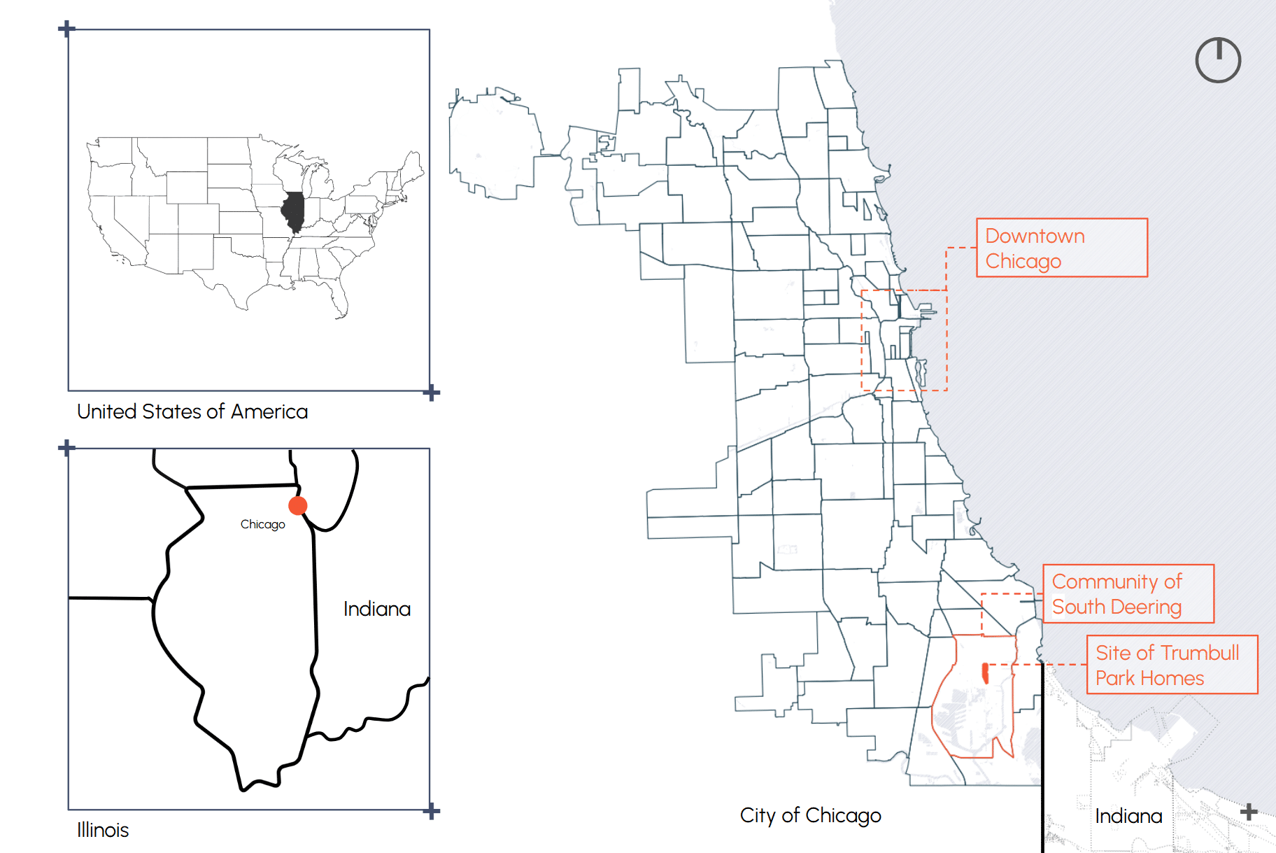
site context
Built in 1938, Trumbull Park Homes (TPH) is a historic public housing development owned and managed by the Chicago Housing Authority (CHA). Images from Google show small brick row-homes among neatly manicured lawns and beautiful old-growth trees — but the development sits on Chicago’s Far Southeast Side, in the heavily industrialised neighbourhood of South Deering.
C40 Competition Brief
The neighborhood sits just north of an area long known as Chicago’s “toxic doughnut” — decades of industrial pollution have led many nearby sites to be designated “Superfund” sites by the Environmental Protection Agency, meaning the land is so contaminated it requires federal cleanup. Through the C40 Students Competition, the CHA asked students to resolve environmental and social issues, this project aims to address the following:
historical context:
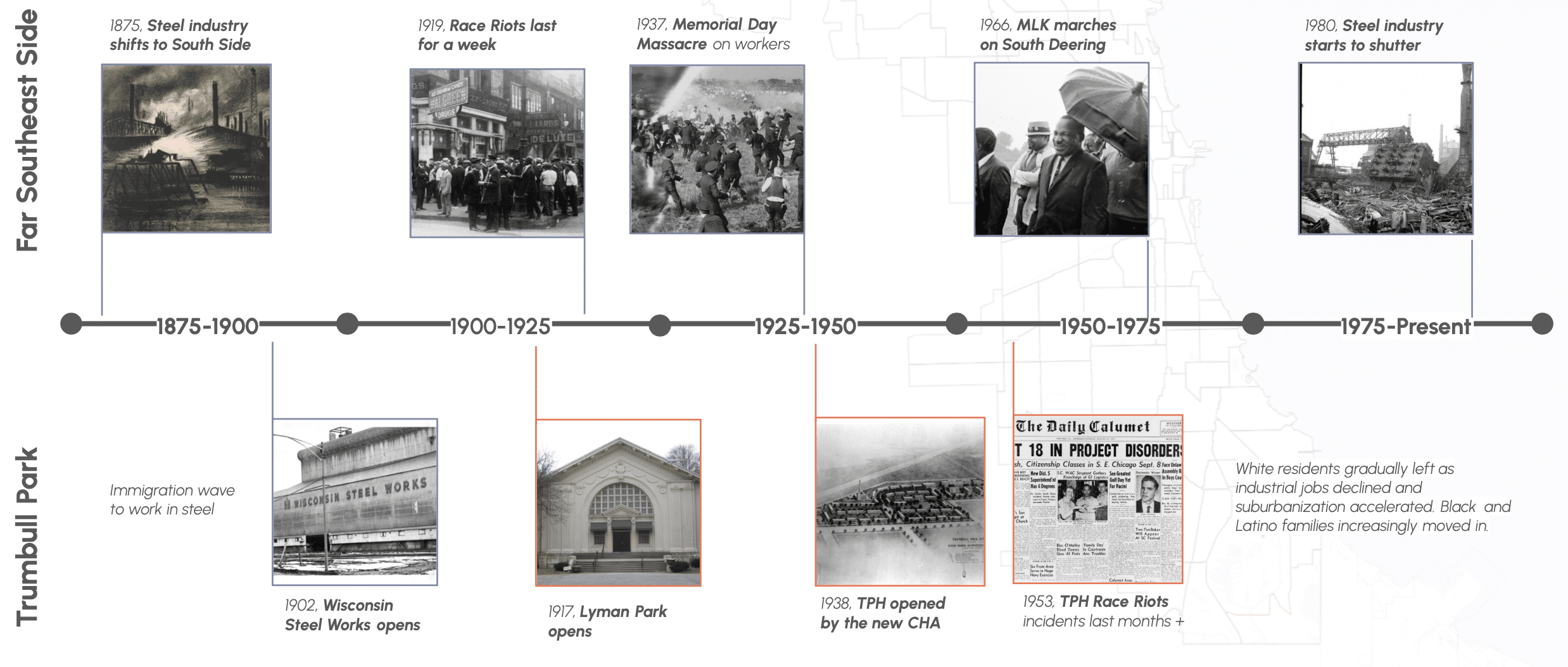
The Far Southeast Side developed around Chicago’s steel industry, drawing immigrant workers and eventually Black Americans to the area. Trumbull Park Homes, built in 1938, housed many of these residents — while surrounding industries left decades of air and soil contamination. In 1953, the CHA’s assignment of TPH’s first Black family triggered months of violent riots by white neighbors. The steel industry’s collapse in the 1980s, compounded by redlining and disinvestment, left lasting economic and environmental consequences.
an encircled community:
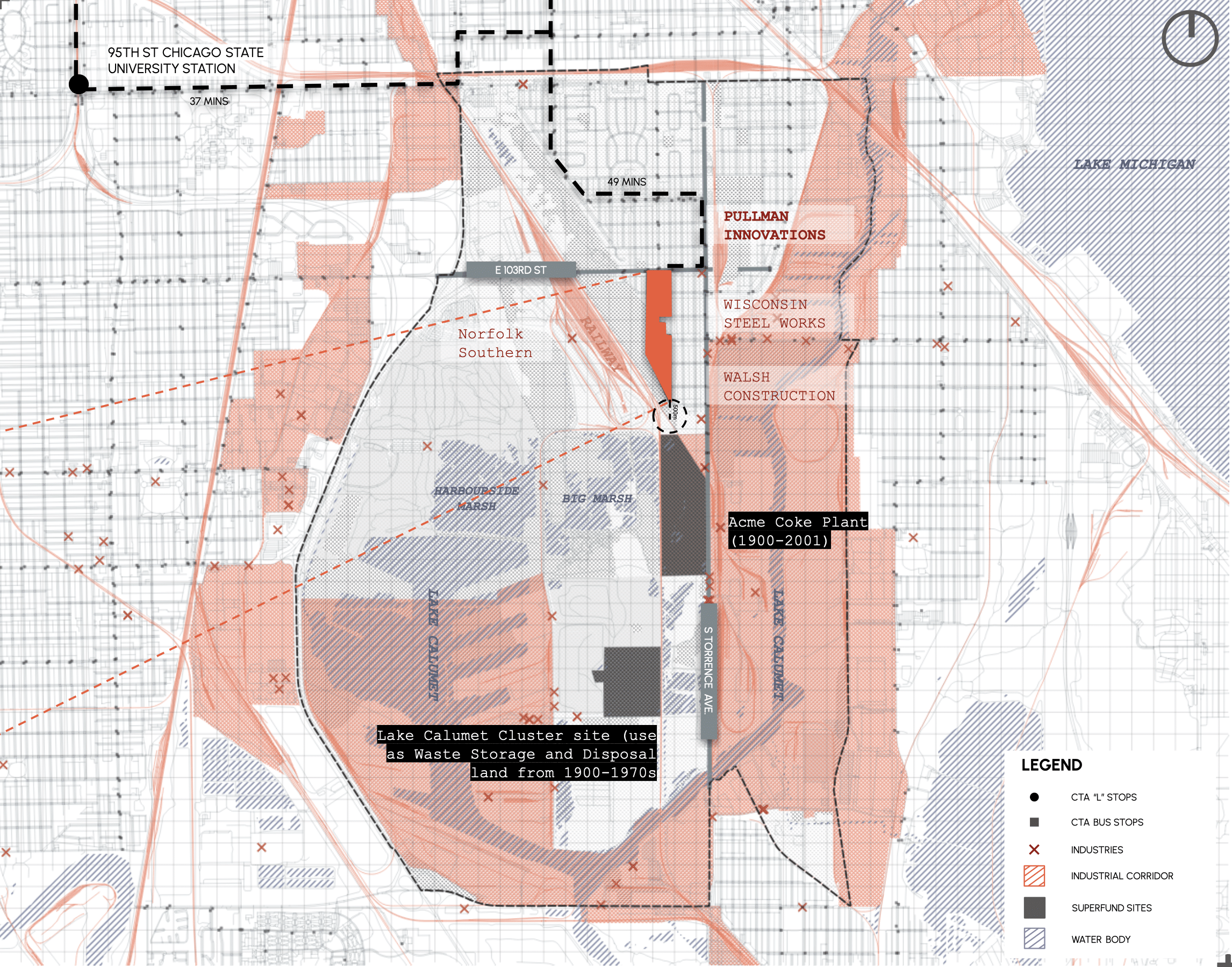
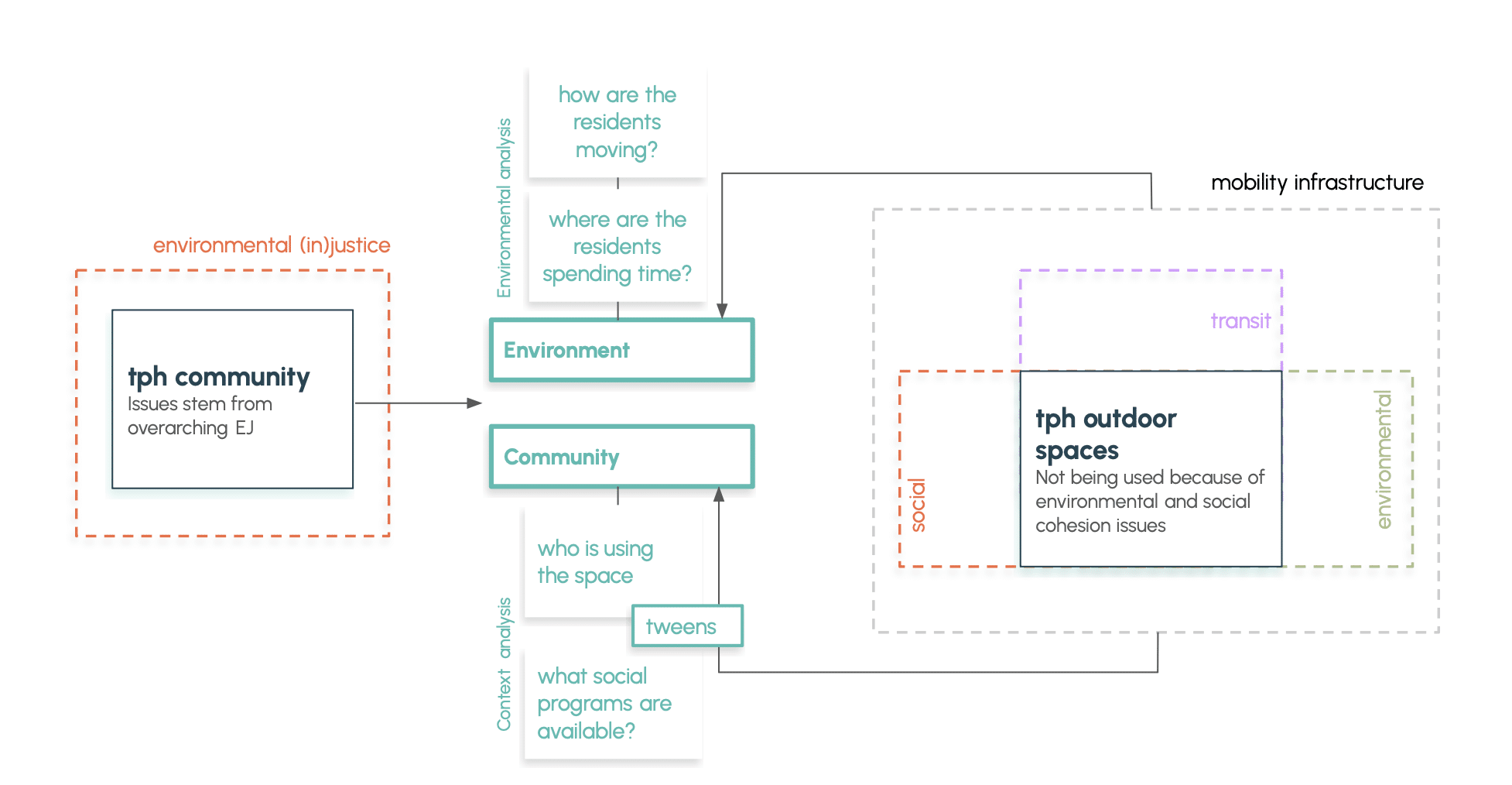
Today, this remains an encircled community. TPH is physically cut off by freight rail lines, highways, wetlands, Superfund sites, and active heavy industry. An ongoing concern noted by the CHA is the site’s proximity to Pullman Innovations, a factory residents say has been emitting a “corpse-like” odor for over 30 years. Chicago has designated South Deering an Environmental Justice neighbourhood — a place that has faced systemic discrimination tied to the characteristics of its population.
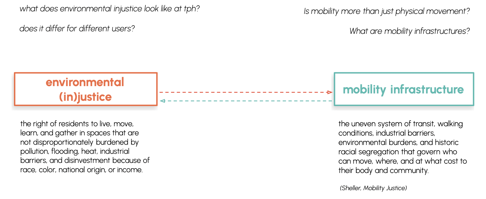
Infrastructures of isolation:
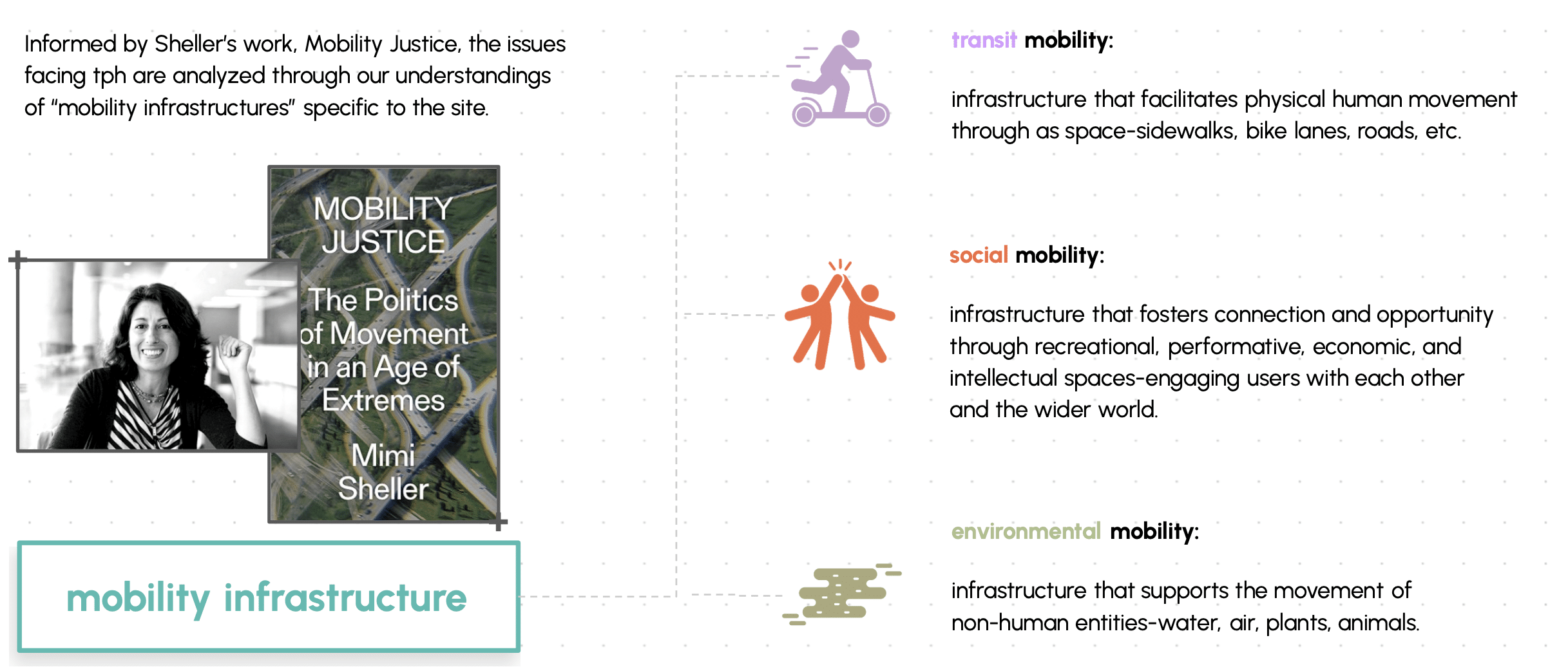
South Deering has faced social and environmental injustices throughout its history — its isolation produced by the very infrastructure designed to move people and economies forward: rail, industry, and policy. But these barriers go beyond the physical. Contemporary mobility researcher Mimi Sheller redefines mobility as a holistic concept: the systems through which power and inequality govern who can and cannot move, shaping the circulation of people, resources, and connections. At TPH, environmental and mobility injustice are one and the same — a community encircled by infrastructure built to serve everyone else
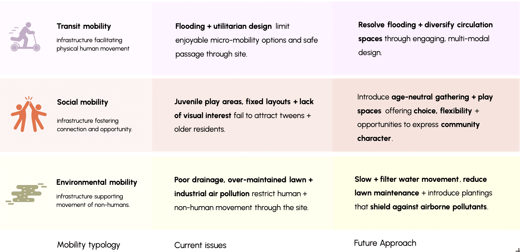
understandings of mobility:
our process : methodology
Our methodology began with environmental injustice as the root issue, then asked: who is most affected, and who is using — or not using — these spaces? That brought tweens into focus. From there, we built a mobility infrastructure framework across all three lenses to re-activate TPH’s outdoor spaces for the whole community.
Research Question
How can tween – centred mobility infrastructure at Trumbull Park Homes be designed for environmental justice? How can designing it through this lens restore the community’s right to move and gather freely?2
objective :
To create comfortable mobility infrastructure in TPH park/outdoor spaces for local tweens to safely move through and enjoy spending time in.
who is moving through tph?
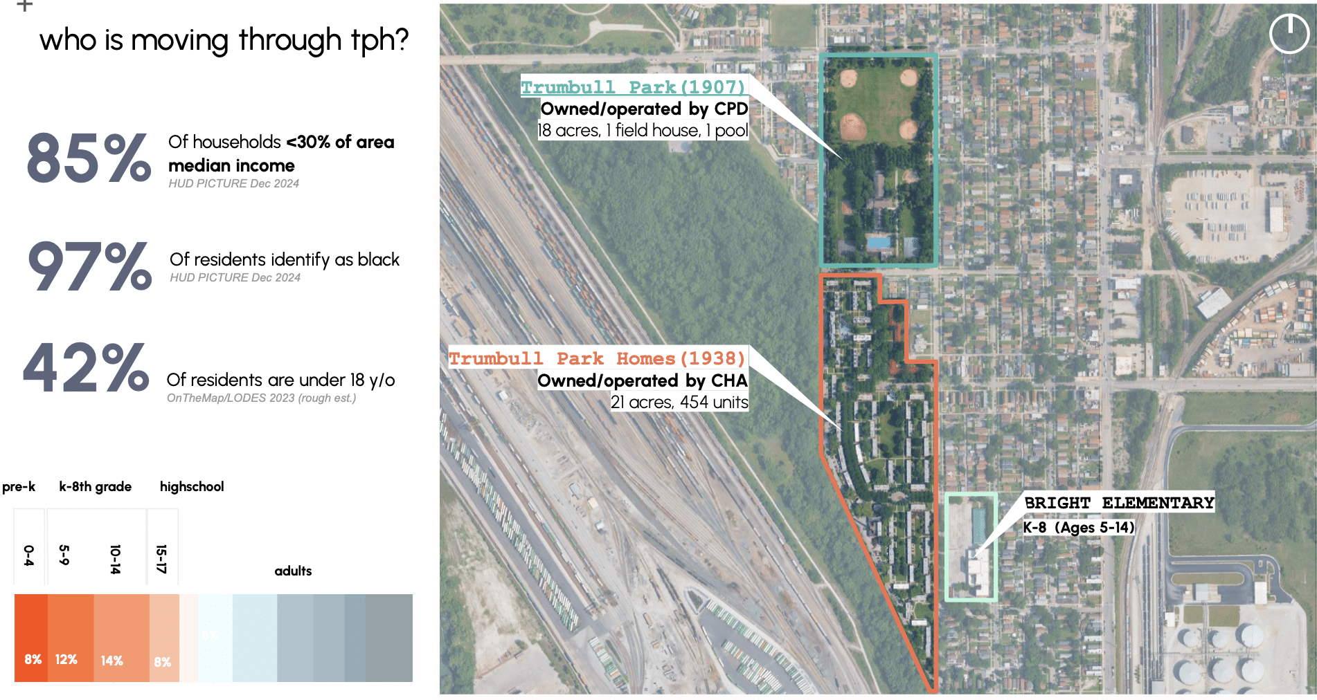
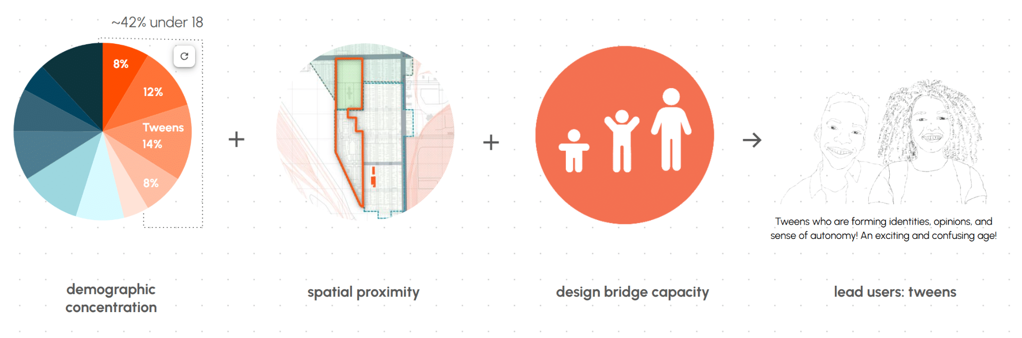
The competition site is split into two distinct sections: the public park, built in 1907 and owned and operated by the Chicago Park District, and Trumbull Park Homes, built in 1938 and owned and operated by the CHA. With 42% of residents under 18, we looked at where young people spend their time — school. The site falls within two elementary school catchment areas, both walkable. Across both schools, roughly 81% of students are economically disadvantaged. TPH residents fall within the Bright Elementary catchment, located immediately at the edge of the site. Burnham Elementary is about half a mile away; Bright is about a quarter mile. High school, however, is not in South Deering — it’s 35 to 45 minutes by bus, not walkable at all. From this finding, we focused our initial analysis on K–8 kids.
after-school activity gaps
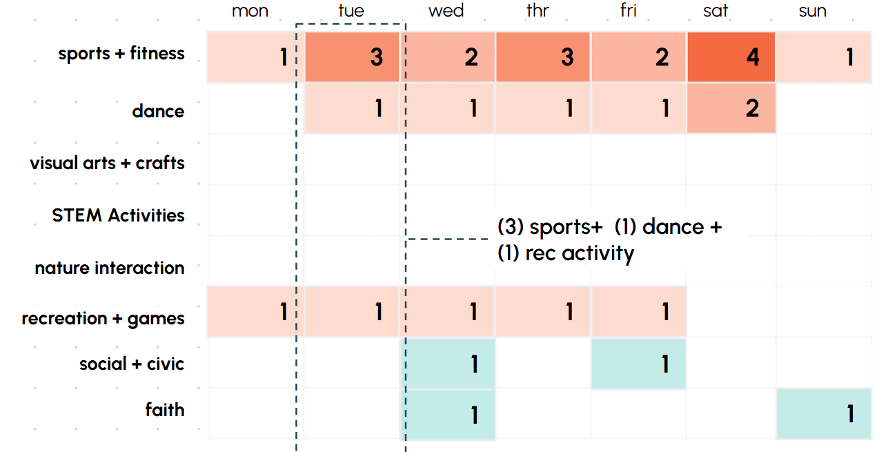
School runs roughly 7:30 am to 2:30 pm on weekdays, with summers off. To understand where kids spend their independent time outside of school, we did community asset mapping focused on organizations most likely to provide structured activities. Using open-source data, we scraped activity information to see which areas hosted the most programs, and when. We found that nearly all available activities within a reasonable 10–15 minute walk are at the TPH recreation center — and only one of them is non-movement-based and secular. There are no STEM or arts programs, and the few options that do exist are clustered on weekends.
youth spaces
The kids are largely confined to the site — so this is where they spend their time. And while it’s green and spacious, it’s plagued by excessive flooding and is visually monotonous: repetitive, with no landmarks and nothing that invites exploration. Research shows that visually homogeneous environments create measurable stress. Zooming out, South Deering has just one documented piece of public art — little in the built environment signals creativity or belonging.
.gif")
user-focus: tweens (9-13 yrs)
From this initial demographic research, we arrived at tweens as our design focus group. At nearly 14% of residents, they are the largest concentration of youth on site and spend the majority of their time at a school that is essentially on-site. This age group is limited to walking but old enough to move around independently — caught between childhood and maturity. Designing for them creates a natural bridge for the entire under-18 population on site.
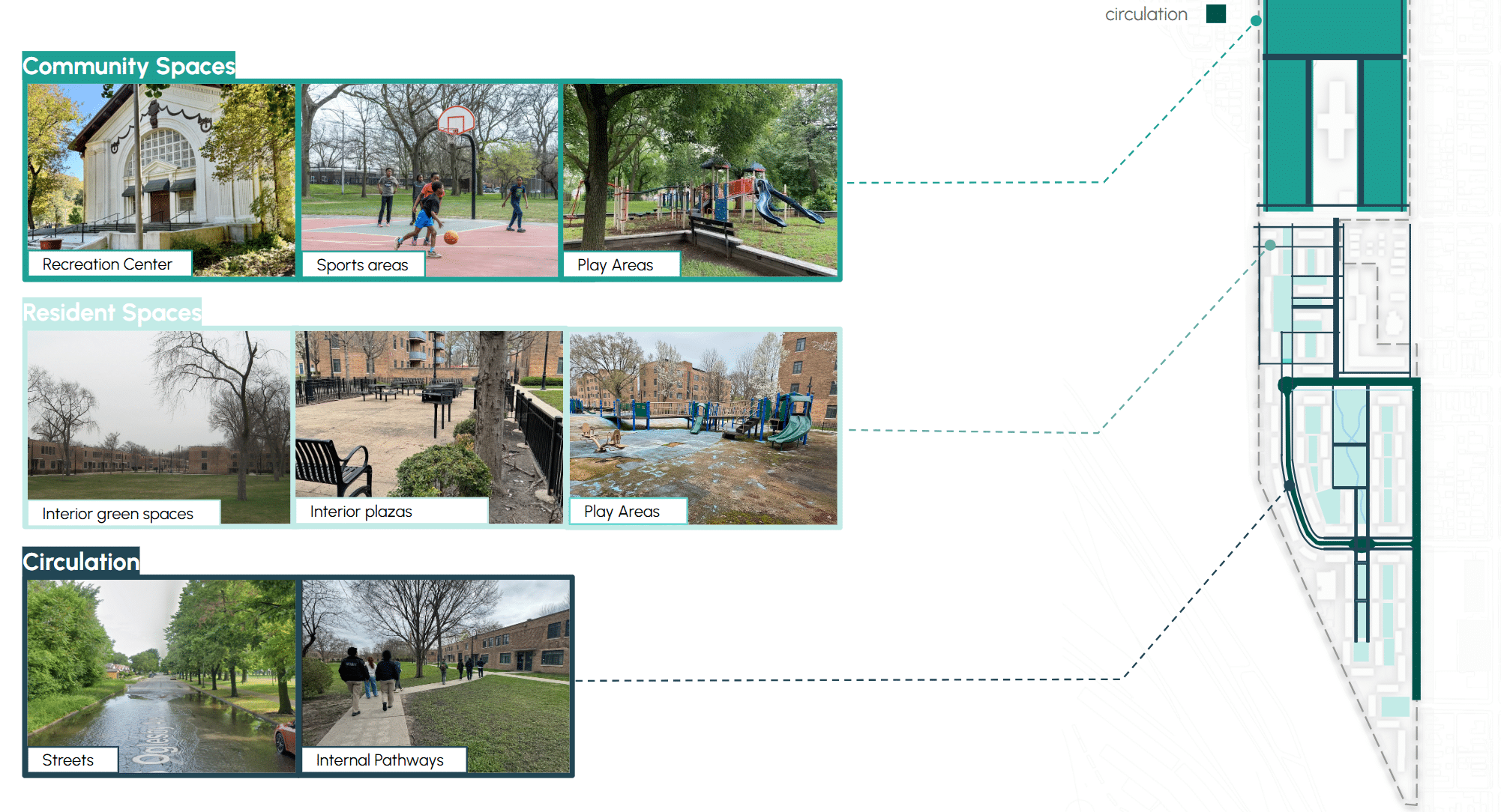
what are the existing public space typologies?
To break down the site, we identified three common space typologies: spaces serving the broader South Deering community, those dedicated to resident use, and circulation spaces in and around the site.
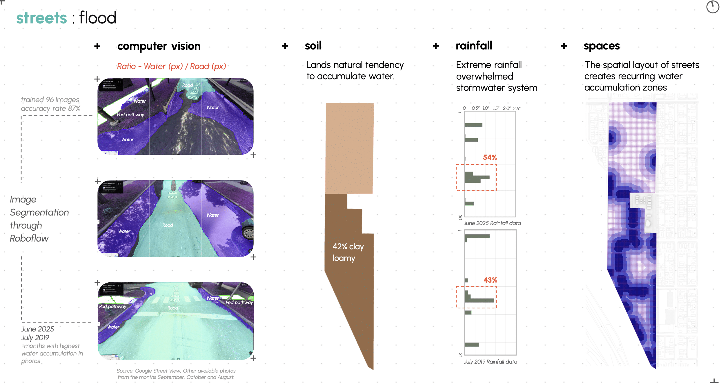
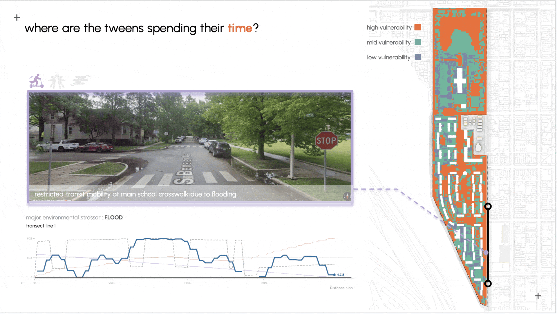
Streets: Flood
Flooding is one of the primary concerns on site, as noted by the client. It blocks street crossings to school and leads to water stagnation. Soil conditions — particularly the high proportion of clay loam — indicate a natural tendency to retain water. Rainfall data suggests that short bursts of intense precipitation can overwhelm drainage, while the street layout itself creates recurring low points where water accumulates. To understand the extent of the issue, we trained 96 Google Street View images through an image segmentation model in Roboflow and identified where flooding occurs and at what severity. Overlaying this with the USDA Soil Survey, we produced a flood vulnerability map. The motorway circulation spaces sit under the jurisdiction of the Chicago Department of Transportation (CDOT) — yet another government entity involved on site.
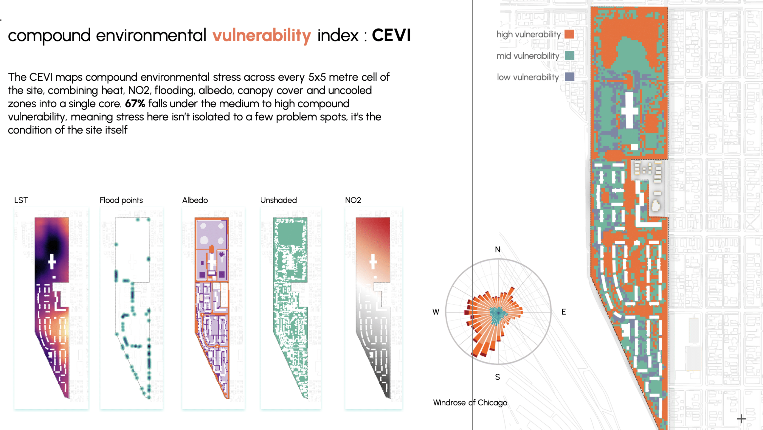
compound environmental vulnerability index : CEVI
This brings us to the Compound Environmental Vulnerability Index (CEVI). CEVI combines six stressors measured across TPH — land surface temperature, NO₂, flood risk, albedo, tree canopy, and uncooled zones — into a single score for every 5×5 metre patch of the site. When mapped, roughly 67% of the site scores as medium-to-high vulnerability. Not because any one problem is overwhelming, but because so many of them are concentrated in the same places.
where are the tweens spending their time?
Residents at Trumbull Park Homes don’t experience environmental stressors one at a time. They experience them together, in the same spaces, every day.
FINDINGS AND APPROACH
Our analysis across all three mobility lenses reveals compounding spatial barriers at TPH — flooding, poor circulation, juvenile design, and industrial pollution all limit who can move, gather, and thrive. Our approach tackles each directly: resolving flooding, introducing age-neutral and flexible spaces, and planting for both biodiversity and air quality.
WHATS OUR RESPONSE?
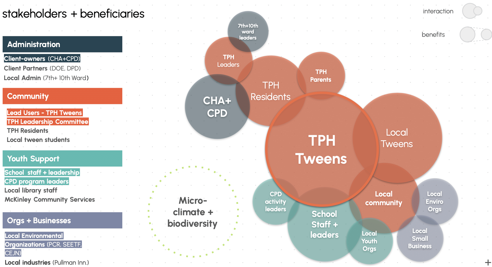
Knowing this is a highly engaged community, stakeholder involvement from the start of design is essential. We mapped stakeholders across four groups: administration, community, youth support, and local organizations. Our primary clients are the CHA and Chicago Park District — but TPH residents, tweens, and school staff are at the center of every decision.
Our one major data gap was the day-to-day lived experience of tweens at TPH. To address this, we designed Scribbly Situations — a serious game run through the CHA with Bright Elementary. Players draw a situation and location card, roll a vibe dice, and have 60 seconds to scribble their response. Real and imaginative prompts are mixed together — a creative co-design session that gets tweens thinking beyond the obvious.
Stakeholder Engagement:
Scribbly Situation
A fast, dynamic, playful and chatty game
AIM: To create a fun, engaging, and creative game to reveal and capture how tweens use and imagine spaces (in Trumbull Hall Park or other Chicago Housing Project).
what is scribbly situation?
Scribble a situation in 60 seconds, then find what’s similar and what’s unique in everyone’s drawings. You all decide what counts — just make sure your explanation impresses the Mayor! So think fast, draw bold! Most points wins.
How can it be implemented ?
The CHA on-site team would reach out to local elementary/middle schools (Orville T. Bright Elementary) about running short workshops to play Situational Scribbles.
The CHA on-site team would facilitate the game in classrooms alongside teachers, and teach kids the game alongside recording observations and qualitative data points in conversations/drawings.
Scribbly Situation is a project of IAAC, Institute for Advanced Architecture of Catalonia developed in the Master in Advanced Architecture 01 – 2025-2026 by the student(s) Lindsay Nier, Chakshu, Reshma Paul and Vijeeth Rao Mandala during the course MUPD01 & MAA01 Serious Games Seminar with Thomas Martin.
Without direct stakeholder input yet, we grounded our spatial decisions in what we heard through interviews and what the analysis revealed. We identified three space typologies to target with design interventions: community spaces, resident spaces, and circulation spaces — each examined through the mobility lenses. Through this process, we mapped the critical areas for intervention, the forces affecting each space, and the type of interventions appropriate to each.
Design Proposal:
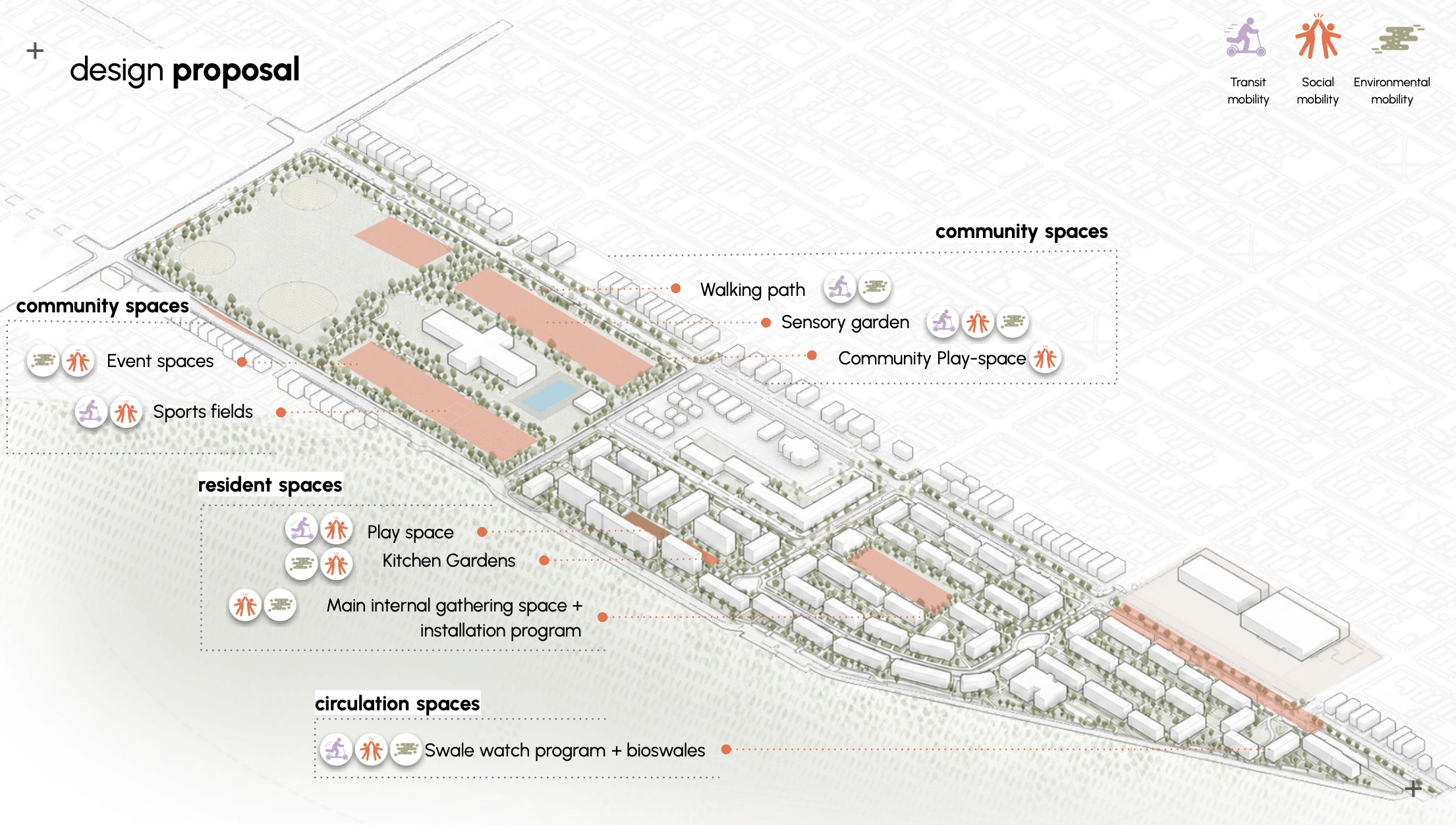
First, circulation spaces — areas with two of the most pressing everyday issues on site: flooding streets and disengaging environments. These become opportunities for play, learning, and ecological repair.
Circulation Spaces:
Through interventions like adventurous routes, tactile urbanism, educational signage, elevated paths, bioswales, and resilient planting, these spaces become safer, more engaging, and more environmentally responsive.
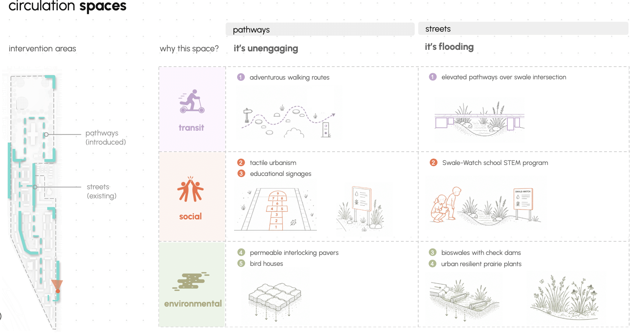
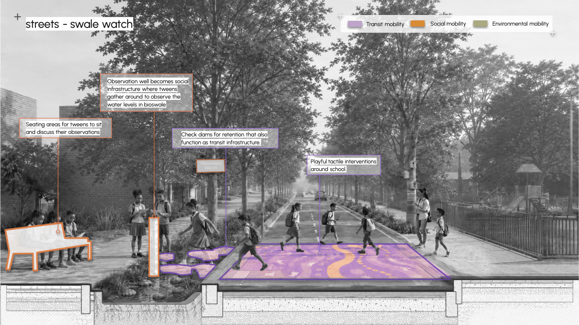
One key intervention addresses street flooding through an educational youth program in collaboration with the school: tweens become stewards of their street, monitoring and interacting with bioswales that are gradually healing their environment. Playful transit infrastructure creates an engaging environment while functioning as stormwater infrastructure — slowing and percolating water. Observation wells become social infrastructure: places where tweens gather to check water levels after rainfall, alongside benches for conversation. The bioswales themselves host prairie-resilient plants such as blue flag iris. The program can be funded through SPP funds, and has an opportunity to sustain maintenance costs through Chicago’s stormwater credit trading system — with tweens as active participants. Through this, the environment gradually heals and the community gains agency.
Resident spaces:
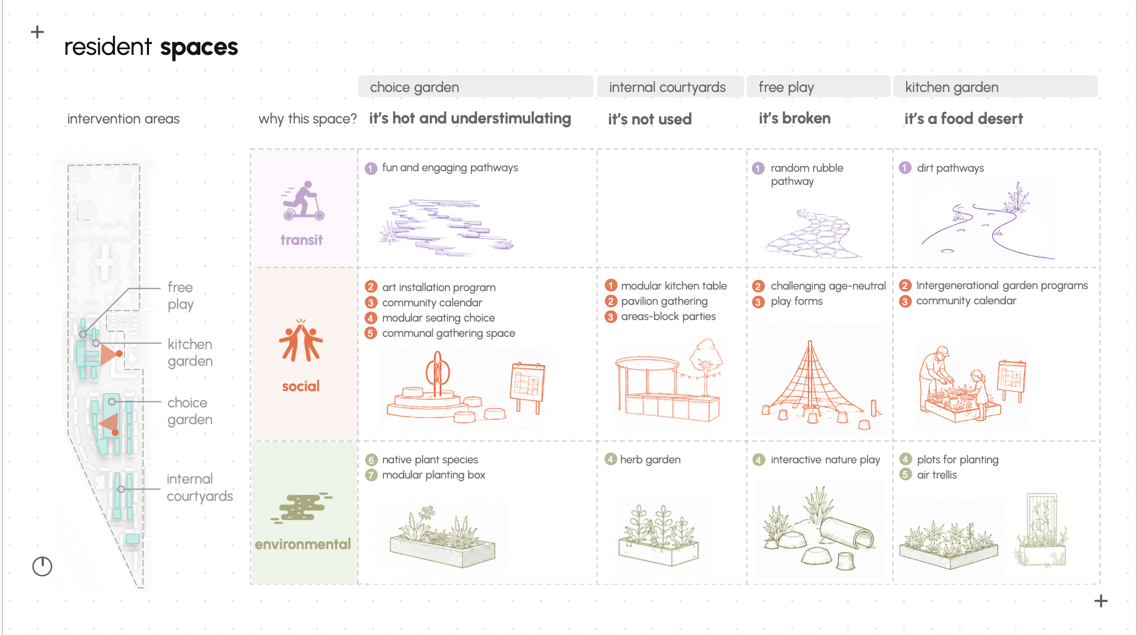
The Choice Garden is the central gathering point for TPH residents. A modular shading pavilion anchors the space — expandable over time and adaptable to weather. Around it: age-neutral play structures, rotating art installations through local CHA partnerships, winding paths that invite discovery, and native planting selected to attract wildlife.
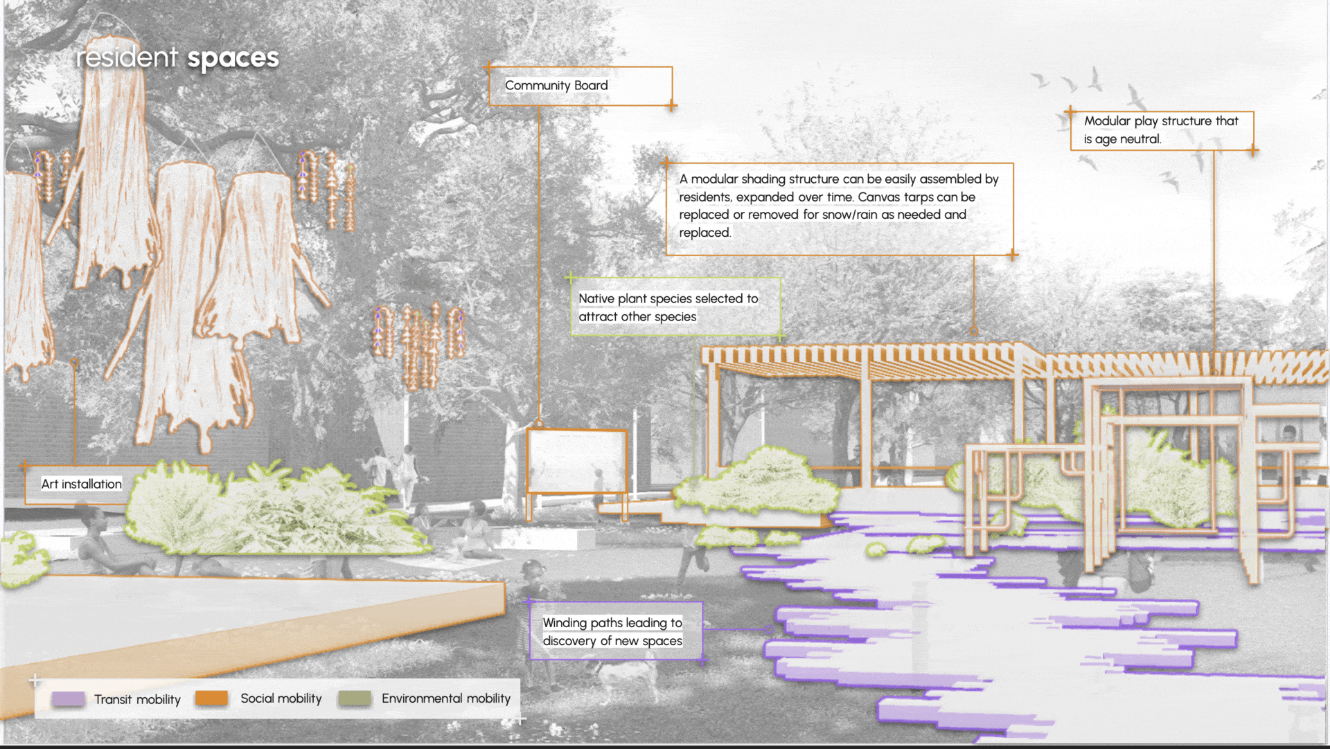
The Choice Garden is the central gathering point for TPH residents. A modular shading pavilion anchors the space — expandable over time and adaptable to weather. Around it: age-neutral play structures, rotating art installations through local CHA partnerships, winding paths that invite discovery, and native planting selected to attract wildlife.
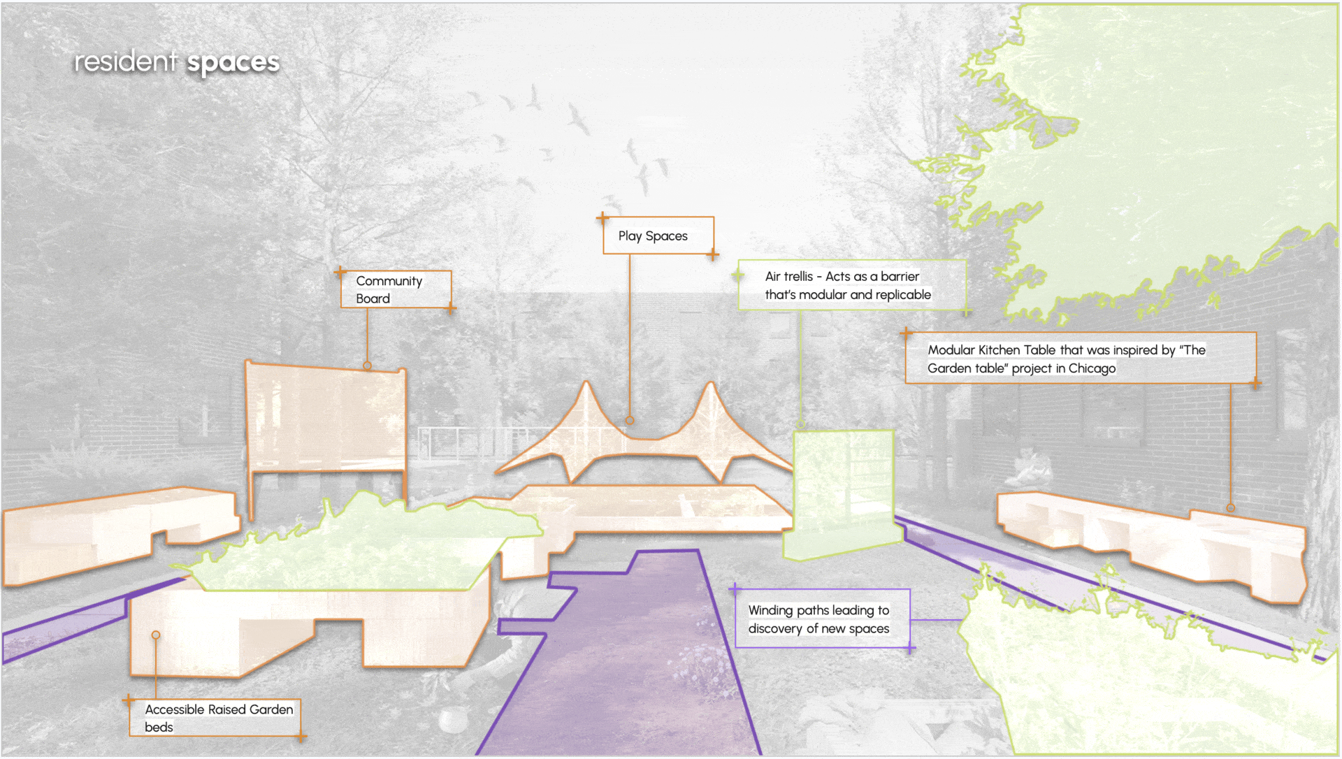
The Kitchen Garden is a more intimate space. Accessible raised beds of varying heights let residents grow food together while contributing to air quality mitigation. A modular kitchen table and community board anchor the space — keeping residents connected to upcoming events and inviting them to propose their own.
Community spaces
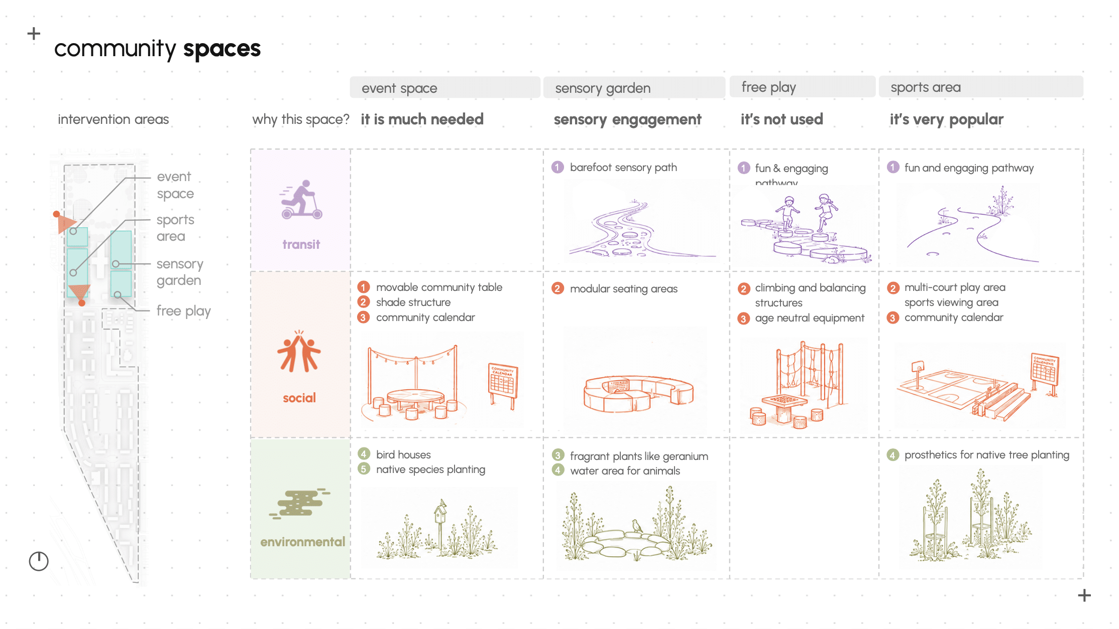
Community spaces sit within the public park. We build on what’s already working — sports and green space — while expanding beyond basketball and manicured lawns to offer more choice. New gathering spaces give the community room to come together, and sensory gardens bring in wildlife while addressing air quality, flooding, and biodiversity.
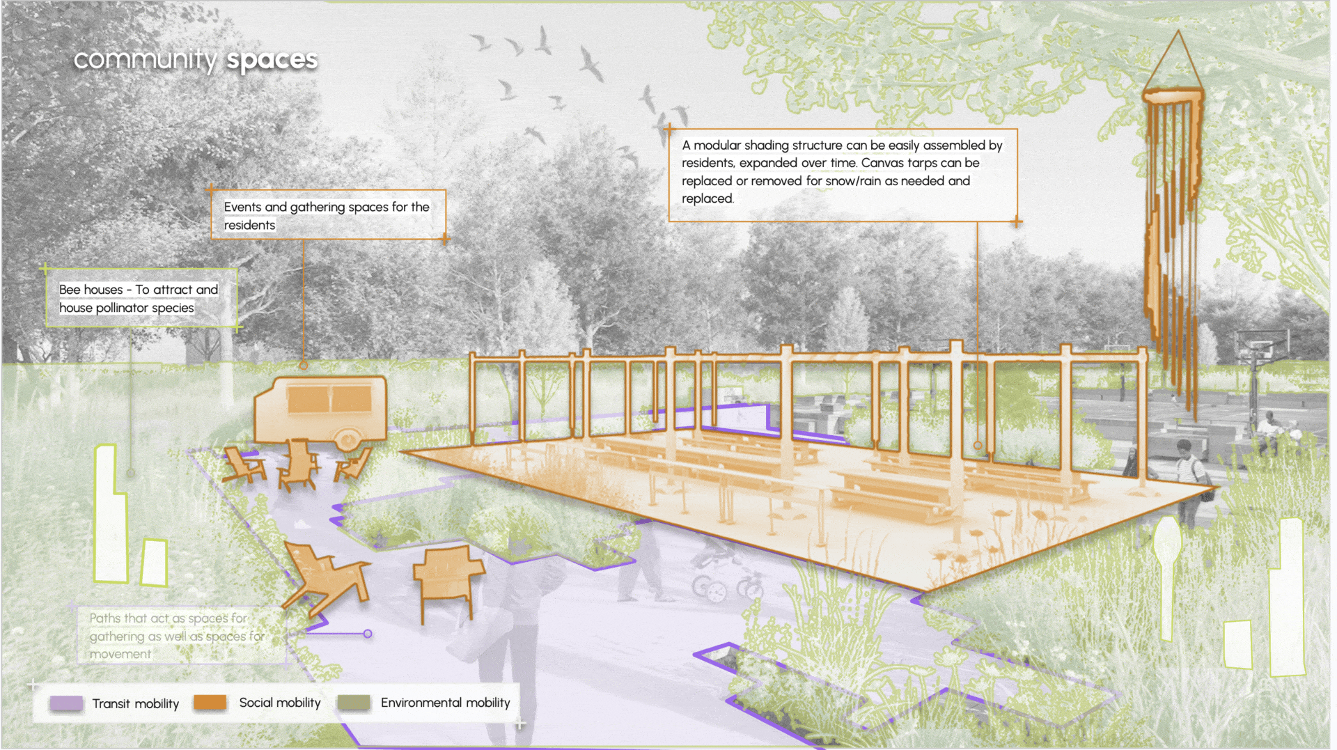
The main gathering space offers flexible seating and shade for large groups. Part of the surface is paved for events, mixed with green and gravel to allow water movement. The modular shading structure is a simple kit — assembled with the community, adapted over time, and finished with painted canvas that expresses community character and comes down in winter.
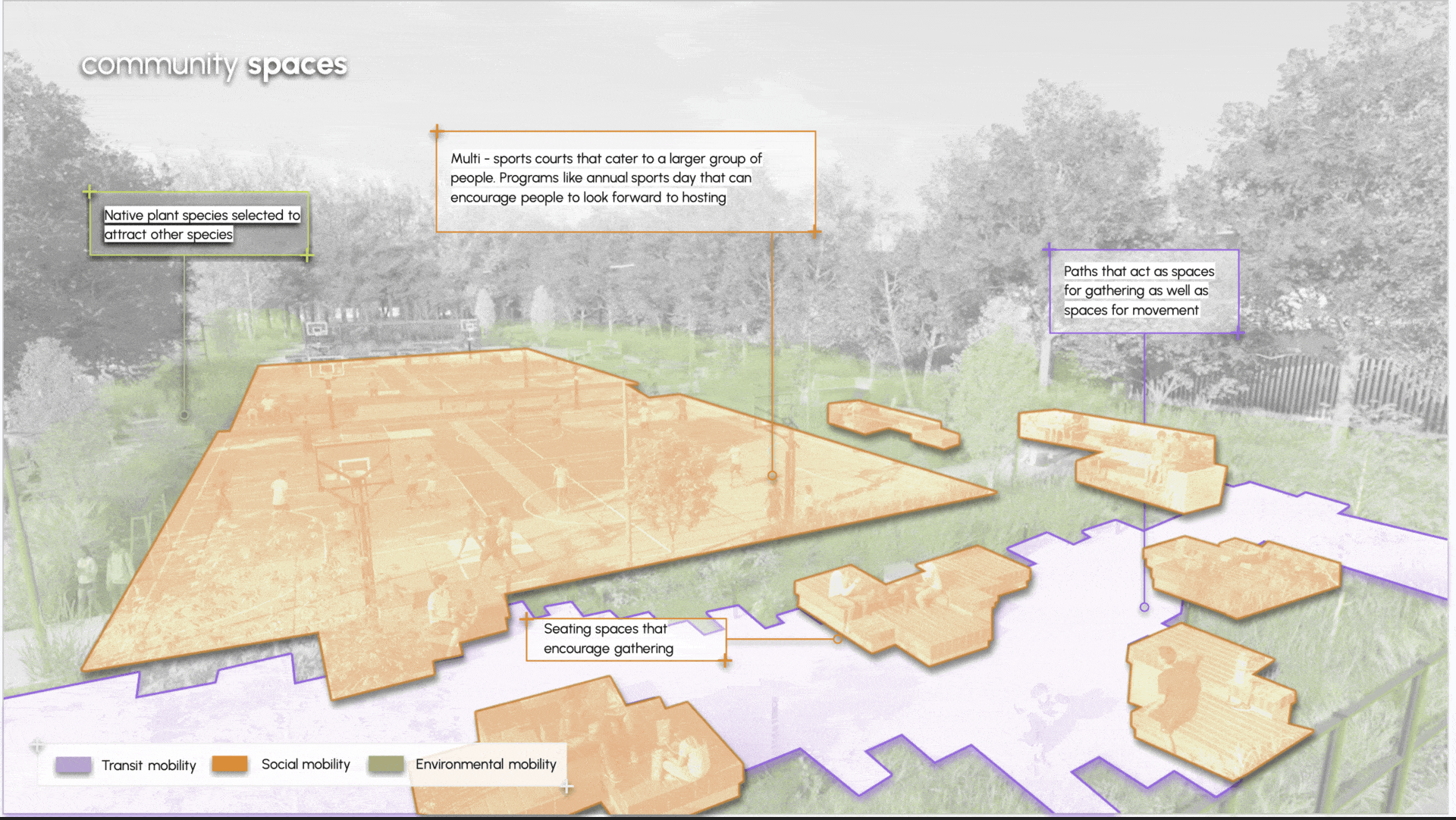
The sports area expands to include multi-use courts for basketball, floor hockey, volleyball, and more. Modular seating wraps the space for spectators and casual hangouts. Paths wind through the area, encouraging movement and engagement with surrounding nature — making the space as much about gathering as about playing.
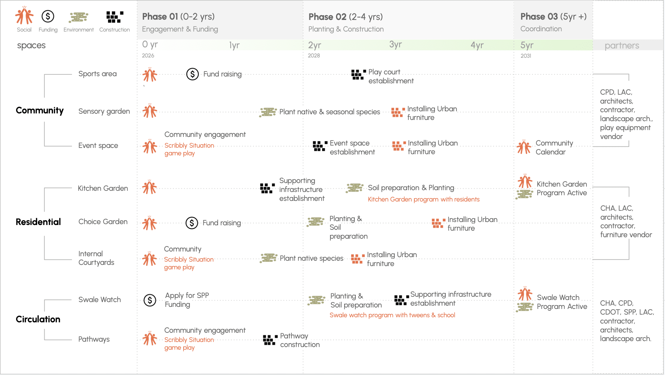
How do we implement?
This graphic translates the proposal into a phased action timeline, showing what happens first, what can run in parallel, and how each space moves gradually from engagement and funding into construction, planting, and long-term community coordination. It also maps partners against each space, revealing the coordination required and who needs to work together to make it happen.
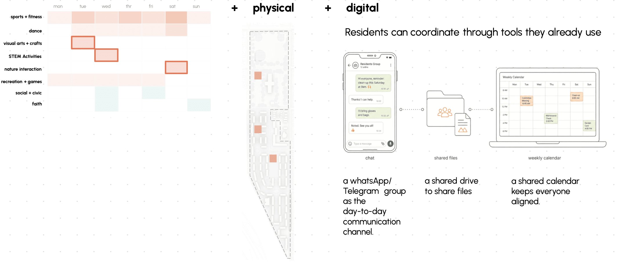
We return to our activity gap data to fill that gap with three new programs in art, education, and nature interaction. The community can begin to coordinate digitally through tools they already use — WhatsApp or Telegram groups, shared drives, and a shared calendar to keep everyone aligned.We also propose three physical community calendar boards that residents can use to self-organize making their own schedules, posting events, and building a shared rhythm for the site.We also propose three physical community calendar boards that residents can use to self-organise making their own schedules, posting events, and building a shared rhythm for the site.
In conclusion, we hope these interventions at Trumbull Park Homes can assist in mitigating environmental issues and creating spaces for gathering that improve social cohesion. With ongoing stakeholder engagement through post-occupancy surveys and the community calendar, the CHA can continue to understand the successes and challenges residents face. These interventions can also bring visibility to the community and draw attention to environmental issues that require broader policy action. And if they’re successful, the CHA can replicate them across their housing portfolio.
Sources:
site context + social analysis + interviews
• American Community Survey. (2024). 5-year estimates: Demographic and housing estimates (DP05) and age and sex (S0101). U.S. Census Bureau.
• Arup. (2017). Cities alive: Designing for urban childhoods.
• Arup. (2023). Playful cities: Design guide — play for anyone, anywhere.
• Chicago Park District. (n.d.). Programs 101. https://www.chicagoparkdistrict.com/programs-101
• Chicago Public Schools. (n.d.). School profiles. https://www.cps.edu/schools/profiles/school-overview
• City of Chicago Department of Environment. (n.d.). Chicago environmental justice action plan. https://www.chicago.gov/city/en/depts/env/supp_info/uncumulative-impact-assessment.html
• Commission for Racial Justice, United Church of Christ. (n.d.). Toxic waste and race in the United States.
• Damour, L. (2016). Untangled: Guiding teenage girls through the seven transitions into adulthood. Ballantine Books.
• Eubanks, V. (2018). Automating inequality: How high-tech tools profile, police, and punish the poor. St. Martin’s Press.
• Hutton, D., Herrington, S., & Brussoni, M. (2022). Seven Cs for tweens: Design principles for children aged 10–13 in the urban landscape. Children, Youth and Environments, 32(2), 1–34. https://open.library.ubc.ca/media/stream/pdf/52383/1.0448193/4
• Lee, C. (2021). Evaluating Environmental Protection Agency’s definition of environmental justice. Environmental Justice, 14(5), 332–337. https://doi.org/10.1089/env.2021.0007
• Lynch, K. (1960). The image of the city. MIT Press.
• Noble, S. U. (2018). Algorithms of oppression: How search engines reinforce racism. NYU Press.
• Noble, T., & Logue, J. (n.d.). Developmental changes in youth’s unsupervised time across middle childhood and early adolescence. Journal of Applied Developmental Psychology. https://www.tandfonline.com/doi/full/10.1080/10888691.2024.2438124
• Nonviolent Action Database. (n.d.). Chicago activists challenge segregation: Chicago • Freedom Movement, USA, 1965–1967. Swarthmore College. https://nvdatabase.swarthmore.edu/content/chicago-activists-challenge-segregation-chicago-freedom-movement-usa-1965-1967
• SE Chicago Historical Society. (n.d.). Digital archive. http://sechicagohistory.org/archive
• Sheller, M. (2018). Mobility justice: The politics of movement in an age of extremes. Verso Books.
• South Side Weekly. (n.d.). Mapping Chicago’s racial segregation.
• The New Lede. (2022, October). Chicago’s Southeast Side pushes back against pollution. https://www.thenewlede.org/2022/10/chicagos-southeast-side-pushes-back-against-pollution/
• U.S. Census Bureau, Center for Economic Studies. (2023). OnTheMap/LODES [Workforce data].
• U S. Department of Housing and Urban Development. (2024). PICTURE database [Housing data].
• U.S. Environmental Protection Agency. (n.d.). NPL Superfund site boundaries (EPA public) [Data set]. ArcGIS Online.
• Community interviews conducted with residents, stakeholders, and local officials across Chicago’s Southeast Side, March-May 2026. Names withheld due to C40 contest rules.
flood analysis + + compound environmental vulnerability index (CEVI)
• Google. (n.d.). Street view [Photographs]. Google Maps. https://www.google.com/maps
• National Centers for Environmental Information. (n.d.). Climate data online. NOAA. https://www.ncei.noaa.gov/cdo-web/
• National Weather Service Chicago. (n.d.). Weather forecast office: Chicago/Romeoville, IL. NOAA. https://www.weather.gov/lot/
• Roboflow. (n.d.). What is image segmentation? https://blog.roboflow.com/image-segmentation/
• U.S. Department of Agriculture Natural Resources Conservation Service. (n.d.). Web soil survey. https://websoilsurvey.sc.egov.usda.gov/app/WebSoilSurvey.aspx
• Chicago Metropolitan Agency for Planning. (n.d.). Calumet area land use plan and design guidelines. City of Chicago. https://www.chicago.gov/city/en/sites/calumet/home.html
• City of Chicago. (n.d.). 2022 Chicago climate action plan. https://www.chicago.gov/city/en/sites/climate-action-plan/home/2022-planning.html
• European Space Agency. (n.d.). Sentinel-5P [Remote sensing data]. Copernicus Programme.
• Google. (n.d.). Street view [Photographs]. Google Maps. https://www.google.com/maps
• Illinois State Water Survey. (n.d.). Ordinary kriging rose: ORD station 13. https://www.isws.illinois.edu/statecli/roses/ord_rose_13.pdf
• Midwestern Regional Climate Center. (n.d.). CLI-MATE: MRCC application tools environment — annual station data. Purdue University. https://mrcc.purdue.edu/newclimate/station/annual-b2d
• U.S. Geological Survey. (n.d.). Landsat 8/9 land surface temperature [Remote sensing data].
• U.S. Environmental Protection Agency. (n.d.). Environmental issues in Southeast Chicago. https://www.epa.gov/il/environmental-issues-southeast-chicago
• U.S. Environmental Protection Agency. (n.d.). Lake Calumet Cluster site community involvement plan. EPA Region 5. https://www.epa.gov/superfund/lake-calumet-cluster
• U.S. Environmental Protection Agency. (n.d.). South Deering neighborhood community involvement [Fact sheet]. EPA Region 5. https://www.epa.gov/superfund/lake-calumet-cluster
• U.S. Environmental Protection Agency. (n.d.). NPL Superfund site boundaries (EPA public) [Data set]. ArcGIS Online.
design information + case studies
• Blaq Gurl Fya. (2026, May 22). Neuro inclusive housing: Introducing neuro inclusion as a design process through a civil rights, environmental justice, and housing justice lens [Webinar].
• Chicago Regional Tree Initiative. (n.d.). Vegetative barrier toolkit. https://chicagorti.org/app/uploads/2023/04/22CRTI_Vegetative-Barrier-Toolkit_0425.pdf
• City of Chicago. (n.d.). Riverdale community area multimodal transportation plan.
• NAI010 Publishers. (n.d.). Play! A cultural perspective on the design of playgrounds. https://www.nai010.com/en/product/play/
• Nowak, D. J., et al. (n.d.). Designing vegetation barriers for urban air pollution abatement: A practical review for appropriate plant species selection. ResearchGate. https://www.researchgate.net/publication/340209281
• Sim, D. (n.d.). Soft city: Building density for everyday life. Island Press.
