
This project investigates the hydrological dynamics and climate vulnerability contributing to severe flooding in Petropolis, Brazil. Focusing on rain-runoff behavior, impervious surface expansion, and topographic influence, the study examines how urbanization has intensified flood risk. A detailed analysis of precipitation patterns and surface drainage inefficiencies highlights the city’s exposure to extreme weather events. Hydrological modeling was conducted to assess stormwater flow and basin response under varying climate scenarios. Four geographically and climatically similar twin cities were analyzed as comparative case studies. The findings aim to inform resilient urban planning and adaptive water management strategies in high-risk terrains.
Climate
Petrópolis, located in the Serra dos Órgãos region of Rio de Janeiro state, has experienced recurrent severe flooding and landslides, with major events occurring in 1988, 2011, and 2022. These disasters resulted in significant loss of life and extensive damage to the built environment. The primary causes of these events were intense rainfall overwhelming the local waterways and triggering widespread landslides. To better understand the climatic conditions contributing to such extreme events, it is essential to examine the region’s rainfall patterns, hydrological features, and drainage infrastructure.
Situated at an elevation of 800 to 1200 meters above sea level, Petrópolis experiences a humid subtropical climate. Its proximity to the Atlantic Ocean strongly influences its precipitation patterns. The summer months, from December
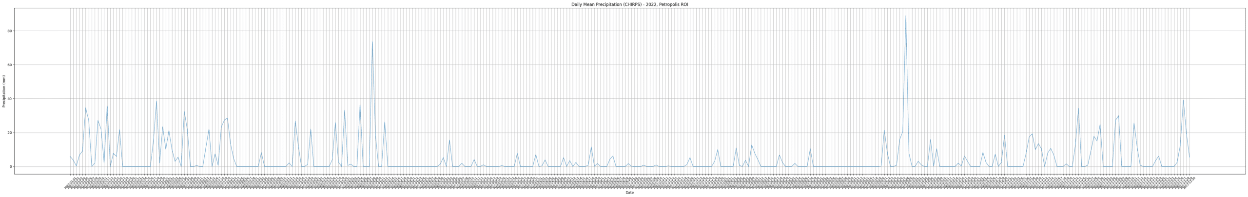
through March, are characterized by intense rainfall, often driven by orographic lift as moist oceanic air is forced upward by the mountainous terrain. This frequently results in heavy downpours, sometimes exceeding 100 mm within a few hours. The city receives approximately 2000 mm of rainfall annually, with summer months typically recording between 200 and 300 mm of precipitation per month. On February 15, 2022, intense rainfall of 258 mm fell over the area in just three hours, causing 230 deaths and severe damage. It remains the most recent major disaster in Petrópolis.
Figure 1: Rainfall in Petropolis
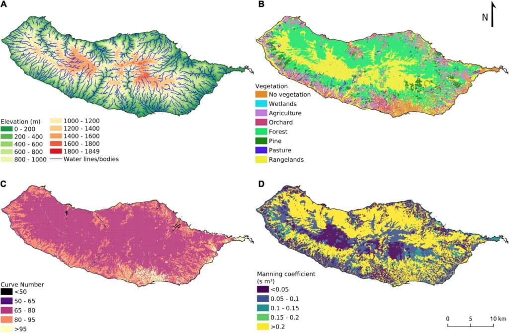
This map illustrates the average annual precipitation in Petrópolis between 2020 and 2025, using data from the CHIRPS remote sensing dataset. CHIRPS combines satellite imagery with ground-based rainfall stations to provide high-resolution precipitation estimates.
The map uses a blue color palette, where: Darker blue areas indicate higher average rainfall, typically occurring over elevated orographic regions. Lighter blue areas show lower precipitation, mostly found in valley zones and lower elevations.The pattern clearly reflects the influence of terrain on rainfall distribution: as moist air rises over hills and mountains, it cools and condenses, resulting in increased rainfall in high-altitude areas. Conversely, lower areas receive less direct precipitation, though they may still be at risk from runoff coming from upslope zones.This map supports the runoff simulation by highlighting how topography shapes rainfall concentration, which in turn informs flood vulnerability patterns across the region.

Water Bodies
The study area is comprised of three primary rivers: the Rio Piabanha, Rio Quitandinha, and Rio Palatino. These rivers are interconnected by a dense network of smaller canals, streams, and tributaries. During the urban planning of Petrópolis, outlined in the Koeler Map of 1846, significant modifications were made to the natural paths of these rivers. One major intervention was the removal of four large river islands, the largest within the Quitandinha basin of which measured 965 m2 .
The removal of river islands reduces the natural capacity of rivers to slow and distribute floodwaters. As a result, river flows become faster and more concentrated, significantly increasing the risk of flash flooding—especially in urbanized and steep landscapes like Petrópolis. Historical cartography has further revealed not only the disappearance of these islands but also a reduction in both the width and length of the Quitandinha River compared to its original configuration in the Koeler Plan.
The Piabanha and Quitandinha Rivers have been central to major flooding events in Petrópolis, notably contributing to the catastrophic floods of 2011 and 2022. The city’s geographical features and its infrastructure limitations have exacerbated the impacts of these flood events. The Quitandinha River basin, in particular, is highly prone to flooding. This vulnerability is the result of several factors: alterations to the river’s natural flow (including the removal of islands), extensive urbanization (which decreases ground permeability and increases runoff), and the inherent geomorphology of the area, which accelerates water flow and promotes the accumulation of floodwaters in low-lying zones.
Drainage
The drainage infrastructure in Petrópolis, consisting of a mix of natural channels and engineered stormwater systems, struggles to manage runoff during extreme rainfall events. Many canals and drains are undersized for current hydrological conditions, while extensive urbanization has increased impervious surfaces, accelerating surface flow. Combined with the city’s steep slopes, these factors cause the drainage system to be quickly overwhelmed during storms, contributing to recurrent flash floods.
Impermeable Surfaces
A recent geoecological analysis of the Quitandinha, Palatino, and Piabanha basins shows a clear link between urbanization and flood risk. The Quitandinha Basin, with the highest proportion of built-up land, experiences the majority of floods, while the more permeable Palatino and Piabanha basins show much lower susceptibility. Increased imperviousness has reduced infiltration and intensified surface runoff, further straining the drainage system during storms.


Vulnerability Analysis
This analysis aims to identify zones of heightened vulnerability to surface water accumulation and flood risk in Petrópolis by integrating simulated rainfall runoff modeling with satellite-based flood data from a known extreme event. Our approach synthesizes parametric simulation, GIS-based classification, and remote sensing analysis to deliver both predictive and retrospective insights into the hydrological behavior of the urban landscape.
Rainfall Runoff Simulation using Grasshopper
The core of our vulnerability analysis is a rain runoff simulation developed using Grasshopper, a parametric modeling environment within Rhino 3D. The simulation utilizes customized environmental physics scripts to model the behavior of rainfall interacting with topography. Key parameters and steps include:
Rainfall Source Distribution: Simulated rain events are distributed evenly across the study area at 115-meter intervals, ensuring comprehensive terrain coverage and spatial consistency. Each rain source emits a hypothetical volume of water, which is then allowed to “flow” based on the local slope conditions.
Flow Accumulation & Drainage Distance: For each point of simulated rainfall, we calculated the Euclidean distance to the nearest catchment area, defined by concave terrain regions or existing drainage basins. This distance acts as a proxy for drainage efficiency—the longer the distance, the more susceptible the area is to prolonged water retention and flooding.
Vulnerability Classification: The results were categorized into a gradient-based vulnerability index, ranging from low (green) to high (red).
Green: Immediate or short-distance access to a catchment area, reflecting low runoff accumulation risk.
Yellow–Orange: Moderate distances, indicating potential water pooling depending on built-up density.
Red: Long distances to drainage points, particularly concerning in steep or urbanized zones. These are the most vulnerable to flash flooding or water-induced erosion.

NDWI Analysis of the 2022 Flood
To verify the validity of our simulation, we performed a Normalized Difference Water Index (NDWI) analysis on satellite imagery from 2022, during which Petrópolis experienced one of its most devastating floods. The NDWI is a spectral index derived from NIR (Near Infrared) and Green bands of multispectral satellite imagery (e.g., Sentinel-2). Interpretation: Positive NDWI values correspond to open water bodies, while negative or neutral values reflect vegetation or dry surfaces. Areas with substantial increases in NDWI compared to a baseline (pre-flood imagery) reveal flooded zones or landslide-affected terrain. Output Classification: The NDWI difference layer was reclassified to highlight abrupt water presence changes. Zones that turned green in the NDWI map signify floodplains, temporary pools, or surface runoff zones visible from satellite during the flood event.
Cross-Validation: Simulated Runoff vs NDWI Flood Extent
A spatial comparison between the simulated runoff vulnerability map and the empirical NDWI flood layer reveals strong correlations: Red zones from the simulation often correspond to green patches in the NDWI map. Several regions with high modeled runoff distance and slope alignment show clear satellite evidence of water accumulation or earth movement. This validation reinforces the accuracy of our Grasshopper-based hydrological model and its relevance as a predictive tool for identifying future flood-prone zones.
Twin City Analysis
La Paz – Bolivia: Risks, response, and social awareness
Historical Triggers of Vulnerability
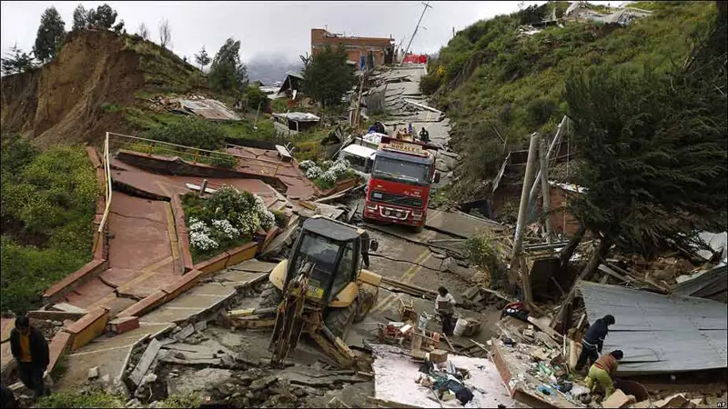
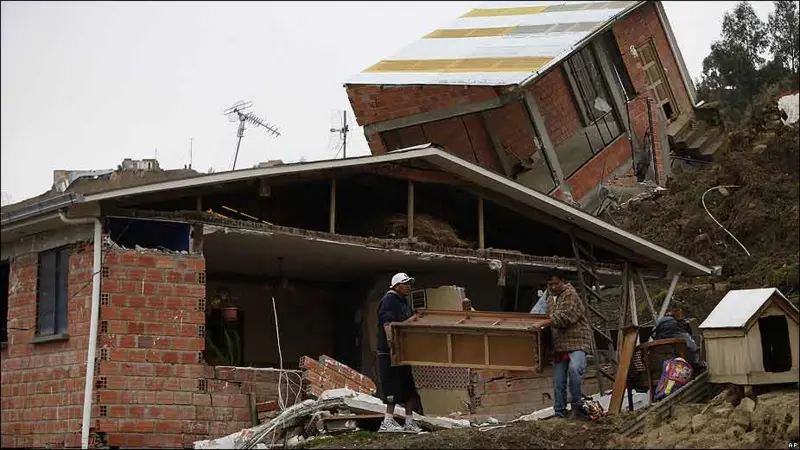
La Paz’s historical and geographical context has played a defining role in shaping its current vulnerabilities. Founded in 1548 and located in a steep Andean valley, the city’s urban sprawl developed on unstable slopes interwoven by over 300 rivers, including the Choqueyapu. Topography becomes essential here, as it not only defines the city’s beauty but also its inherent risk. Despite early warnings—such as the 1977 studies identifying natural hazards—urban development continued in high-risk zones. Landmark disasters like the 2002 hailstorm and the 2011 mega-landslide exposed the consequences of poor planning and highlighted the structural dangers exacerbated by informal settlements on geologically fragile terrain.
Policies of Reaction and Resilience
In response to recurring disasters, La Paz’s government initiated urban policies aimed at strengthening resilience. Through EMGIR and PBCV, authorities attempted to integrate risk management into urban planning. The Response captures the core municipal approach: mapping vulnerabilities, building infrastructure, and mobilizing emergency systems. These strategies led to tangible interventions such as retaining walls and early warning systems. However, while such actions mitigated immediate risks, they often lacked a structural vision to address the root causes. The success of housing relocation and neighborhood upgrades contrasts with the persistent issues of informal growth and inadequate regulation
Urban Risk and the Power of Informality
Socioeconomic dynamics significantly fuel urban vulnerability in La Paz. Informality represents more than illegal settlements; it includes land trafficking, speculative housing, and construction on risky terrain. Here, housing operates as economic security rather than safe shelter, undermining regulatory efforts. Risk perception remains low, and the physical infrastructure—such as sanitation systems—is frequently degraded, worsening the danger. Coordination between La Paz and El Alto remains weak, despite their intertwined geography, and existing community-based awareness initiatives struggle to shift the cultural mindset that treats risk as a distant or external concern.

Toward a Unified Vision of Resilience
La Paz’s future resilience hinges on its capacity to address not just technical deficiencies but deeper institutional and social gaps. The Integration is critical—suggesting a need for a holistic model that unites environmental, social, and political efforts. Rather than relying solely on infrastructure, the city must foster active civic participation and shared responsibility. Combating corruption, enforcing land use laws, and strengthening metropolitan governance are all vital. Only through such systemic transformation can La Paz escape the cycle of risk and build a truly sustainable and safe urban environment.
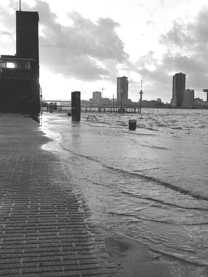
Rotterdam’s Water Management Solutions
Technology / Rooftops / Radars
Rotterdam is not your average city. Famous for being one of Europe’s busiest ports, it also holds an unusual record: about 85% of the city is below sea level—some areas as deep as seven meters below. Living here means living with constant threats from floods, storms, and rising seas. In fact, Rotterdam learned the hard way. The disastrous North Sea flood of 1953, which impacted the Netherlands, Belgium, and the UK, taught the Dutch that traditional defenses weren’t enough. The city had to think differently, leading to groundbreaking infrastructure projects like the famous Delta Works.
But today, the story is about more than just massive barriers and dams. It’s about technology, smart roofs, and involving residents directly in flood management.
“Water comes from everywhere—the sea, rivers, rain, groundwater. We have to make every square meter count.”
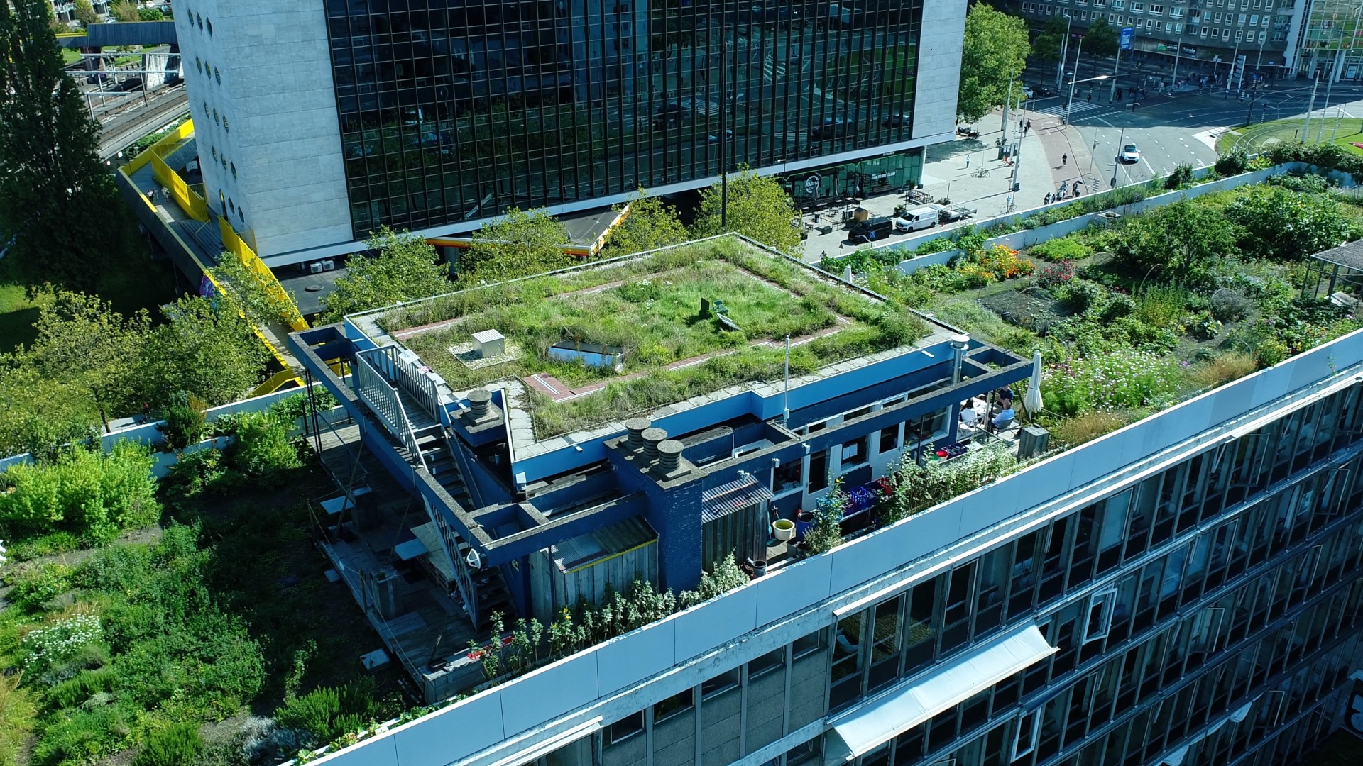
One of Rotterdam’s most interesting strategies is its sophisticated radar system placed on top of the city’s tallest building. This radar is extremely accurate and tracks rainfall up to 20 kilometers away. But it doesn’t just predict weather—it actually controls the city’s network of special roofs designed to handle rainwater in smart ways. These roofs are called blue-green roofs, combining green gardens with hidden water tanks. When heavy rain is predicted, the roofs automatically empty their tanks beforehand to create space for new water. During storms, they trap rainfall, holding it back from overloading city drains and causing street flooding.
Paul van Roosmalen, who manages Rotterdam’s public sustainability projects, says this clearly: “Water comes from everywhere—the sea, rivers, rain, groundwater. We have to make every square meter count.” Rotterdam’s ambitious goal is to transform one million square meters of rooftops into smart retention spaces, proving that flood protection can also create a greener, healthier city.
Rotterdam also uses technology to involve people directly in flood management. The FloodCitiSense project encourages local residents to use simple, inexpensive sensors to monitor rainfall and street flooding. This citizen-led effort provides a clearer picture of flood risks across neighborhoods, filling gaps left by official city monitoring systems.
In a similar project, co-created by Fab Lab Barcelona and Amsterdam Municipality, citizens use the “Smart Citizen Kit” to collect data on local climate conditions. This approach doesn’t just produce useful data; it helps residents feel involved in protecting their own communities from floods.
“It’s a complex system, where human expertise and technological innovation work hand in hand.”
Rotterdam’s flood protection is still built around powerful physical infrastructure. The Delta Works project, launched after the 1953 disaster, includes iconic storm barriers like the Maeslantkering. This giant barrier closes automatically if the North Sea threatens to surge into the city, protecting thousands of people and vital economic infrastructure. Another important barrier, the Hollandse IJssel, operates more regularly to manage smaller flooding events.
Yet even these monumental structures aren’t enough on their own. Rotterdam’s local waterboards maintain dykes, canals, and pump stations, keeping daily water levels carefully balanced. It’s a complex system, where human expertise and technological innovation work hand in hand.
Today, Rotterdam is using sophisticated computer models like 3Di and TUFlow to understand flooding better. These simulations let city planners anticipate exactly how water moves through the urban landscape, improving the city’s preparedness.
Rotterdam also applies advanced methods such as stochastic weather generators—computer tools that create thousands of possible rainfall scenarios to help planners prepare for the unexpected. And with BlueLabel, a public platform assigning flood-risk ratings to every building, the city is helping its citizens understand their personal risk clearly and simply.
Ultimately, Rotterdam’s approach to flood protection is about more than safety—it’s about turning a challenge into an opportunity. The city uses flood defenses to make urban life greener, cleaner, and more connected. Parks that absorb rain, rooftops that retain water, and communities actively participating in flood resilience—this is how Rotterdam imagines its future.
New Orlean’s Flood Management
History
New Orleans is bordered by the Mississippi River to the south, Lake Pontchartrain to the north, and surrounded by marshes and shallow lakes like Lake Borgne, connecting it to the Gulf of Mexico. Its low-lying, bowl-shaped geography makes it particularly prone to flooding.
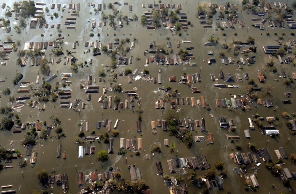
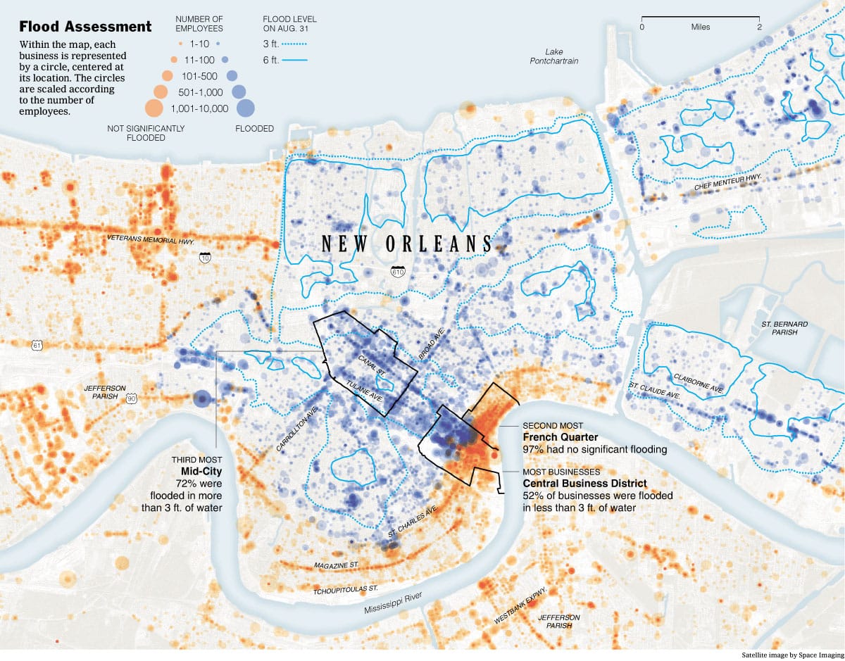
On August 29, 2005, Hurricane Katrina struck New Orleans as a Category 3 storm during its second landfall, after reaching Category 5 strength in the Gulf of Mexico. The city suffered catastrophic flooding due to over 50 levee breaches caused by design and construction flaws, submerging 80% of New Orleans under water as deep as 20 feet in some neighborhoods.
Katrina resulted in approximately 1,300 deaths in the city (1,800 overall), the destruction or severe damage of about 200,000 homes and businesses, and an estimated $150 billion in damages. It was also the first time a mandatory evacuation order was issued for the city.
City Response
To strengthen infrastructure and better protect the city, New Orleans built a 180-mile-long, 30-foot-high surge barrier east of the city to block storm surges from reaching populated areas. Levees and floodwalls were redesigned using compacted soils and reinforced concrete, with structures like T-walls and I-walls providing extra stability against water pressure.
New floodgates and sector gates were constructed at road, railway, and waterway crossings, allowing for normal traffic but sealing off water during storms. In addition, the city installed Permanent Canal Closures and Pumps (PCCP), a system of gates and massive pumps that can remove up to 400,000 gallons of rainwater per second from within the city and push it back out beyond the flood barriers.
Managing heavy rainfall inside the city also became a major focus. A system of canals and internal pumps was enhanced to quickly drain rainwater, with the capacity to pump out 4.7 inches of rain in just three hours, significantly reducing the risk of flash flooding during storms.
Maintenance has proven essential to the system’s success.
Regular inspection and upkeep of drains, pipes, and canals ensure that flood protections function properly when needed. Due to the sinking coastline and rising sea levels, the city must continuously upgrade its flood defense structures beyond the original 100-year protection plan. Restoring wetlands and barrier islands around New Orleans is another important strategy, as these natural features help slow down storm surges before they reach the city.
Emergency preparedness efforts were also significantly updated. Stricter building codes were introduced to ensure that homes and businesses are built to withstand future storms. Evacuation plans were improved with the creation of a contraflow system to speed up outbound traffic during emergencies, transportation support for people without cars, and the establishment of additional shelters of last resort for those unable to leave the city.
Early warning systems were expanded, including texts, calls, emails, Wireless Emergency Alerts (WEA), outdoor warning sirens, and real-time flood sensors to keep residents informed and safe.
Finally, New Orleans launched several community programs aimed at long-term resilience. Regular risk assessments are now conducted every five years to gather comprehensive data on flood risk and update planning accordingly. Incentive programs were created to encourage residents to move out of high-risk areas and to reward builders and homeowners who exceed basic safety standards, helping to make the city more resilient against future disasters.
MADEIRA FLOOD MANAGEMENT
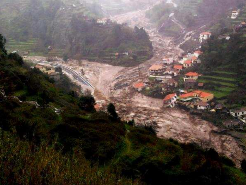
Madeira Island, a Portuguese archipelago in the Atlantic Ocean, has faced several devastating flooding events between 2009 and 2021, causing significant damage to infrastructure, property, and human life. These floods are characterized as “torrential floods” – hydrogeomorphologic events involving interactions between slope movements (landslides, debris flows) and fluvial dynamics (flash floods), typical in mountainous regions with deep, narrow-bottomed valleys
The most catastrophic flood occurred on February 20, 2010, primarily affecting the southern side of the island, resulting in approximately fifty deaths and leaving widespread destruction1. Other significant flooding events occurred in December 2009, January 2012, November 2013, December 2020, and January 2021, affecting various parts of the island, particularly on the northern side.
The December 2020 floods were particularly severe, resulting in 27 displaced persons and causing damage estimated at EUR 40.6 million to road networks, fluvial infrastructures, houses, irrigation systems, and electrical power lines. These recurring events have highlighted the vulnerability of the island to extreme precipitation and the urgent need for effective flood management strategies.
During Carnival week in one of these flooding events, an Atlantic storm struck unexpectedly. As described by eyewitness Ricardo Reis: “It was a torrential downpour, and once it had started, it went on, and on. The water came cascading down the steep slopes of the mountains. In one moment, mud and water gushed down the streets and buildings”
Old School Strategies and Methods in Flood Controlling
Before the implementation of the integrated flood management systems seen today, flood control in Madeira likely relied on more conventional approaches. Although the search results don’t explicitly detail historical flood control methods in Madeira, we can infer traditional approaches based on the context and descriptions of flooding events and subsequent rebuilding efforts.
New Modern Strategies
Following the devastating floods, particularly the 2010 disaster, Madeira implemented several modern and innovative strategies to enhance flood resilience. The European Investment Bank provided a EUR 62.2 million loan as part of a post-disaster emergency operation to finance the total project cost, enabling the implementation of comprehensive approaches to flood management.
Solid Slit Dams
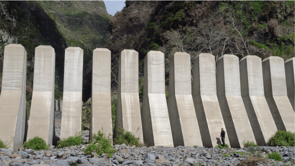
One of the most significant modern interventions has been the construction of solid slit dams controlling water flow to each of the three main streams in Funchal as they rise in the uplands and empty into the sea. These innovative structures consist of concrete walls with “teeth,” standing 10 meters tall, designed to retain solid material in floodwater while allowing the finest material to pass through the gaps
This approach effectively reduces the destructive potential of debris-laden floodwaters by trapping rocks and larger debris upstream, preventing them from reaching populated areas where they can cause severe damage to structures and infrastructure. An additional benefit of this approach is that the captured solid materials are now used for civil construction, creating an economic opportunity from what would otherwise be hazardous debris
Comprehensive Early Warning System
A sophisticated early warning system has been implemented throughout the island, comprising multiple integrated components:
- Meteorological radar for detecting approaching storms and monitoring rainfall intensity
- Measuring stations positioned strategically across the territory to provide real-time data on rainfall and water levels
- Integrated civil protection early response protocols that enable coordinated action by emergency services
- Detailed emergency plans that establish procedures for different flood scenarios
This system enables authorities to anticipate flooding events and take proactive measures to protect vulnerable communities before disasters occur. The early detection of potentially dangerous rainfall patterns allows for timely evacuation and deployment of emergency resources, significantly reducing the risk to human life.
Environmental Restoration and Nature-Based Solutions
Recognizing the role of vegetation in flood mitigation, Madeira has implemented a massive replanting program of sustainable, autochthonous (native) trees and bushes at medium and high altitudes. This approach plays an important role in preventing landslides while contributing to a sustainable environment and adaptation to climate change.
Vegetation helps stabilize slopes, reduce surface runoff, and increase infiltration, all of which contribute to flood mitigation. By restoring native plant communities, this strategy enhances the island’s natural resilience to extreme precipitation events while providing additional ecological benefits such as habitat creation and carbon sequestration.
Conclusion
The flooding in Madeira Island represents a complex challenge that requires multifaceted solutions addressing both the physical hazards and social vulnerabilities. The island has transitioned from traditional, often reactive approaches to flood management to a more comprehensive, integrated strategy that combines structural measures, early warning systems, and nature-based solutions.
The innovative approaches implemented in Madeira, particularly following the catastrophic 2010 flood, demonstrate how disasters can catalyze transformative change in risk management. The solid slit dams, comprehensive early warning systems, and environmental restoration programs represent significant advances in flood risk reduction that have enhanced the island’s resilience to extreme precipitation events.
The parallels between Madeira and Petrópolis highlight the global nature of flood risk in mountainous regions and the importance of international knowledge sharing. As climate change potentially increases the frequency and intensity of extreme precipitation events, the lessons learned in Madeira may become increasingly relevant for similar regions worldwide.
Moving forward, continued investment in both structural and non-structural measures, combined with strong community involvement and international cooperation, will be essential for further reducing flood risk in Madeira and building a more resilient future for the island’s communities.
