
This project focuses on accessibility and orientation between nearby schools and Parc dels Pins in Santa Coloma de Gramenet. It emphasizes children and inclusion. Through co-creation with local schools, the design tests inclusive wayfinding strategies using sensory and tactile signage. These aim to improve safety, visibility, and spatial awareness. The process brings together children, educators, municipal staff, and designers. Together, they create a child-centered network of paths that encourage independence, build local identity, and connect schools to the park.
INE – Instituto Nacional de Estadística. 2021
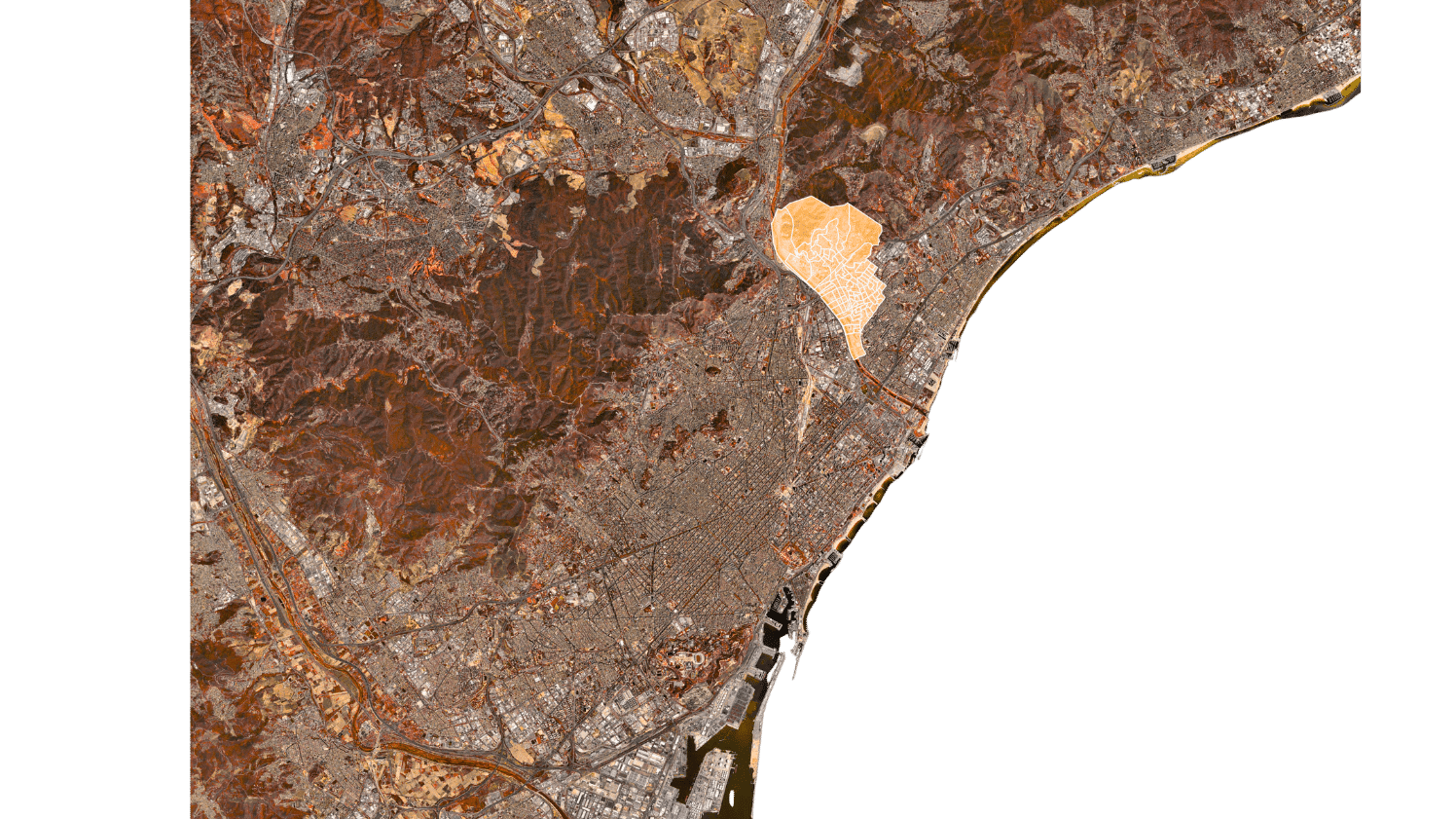
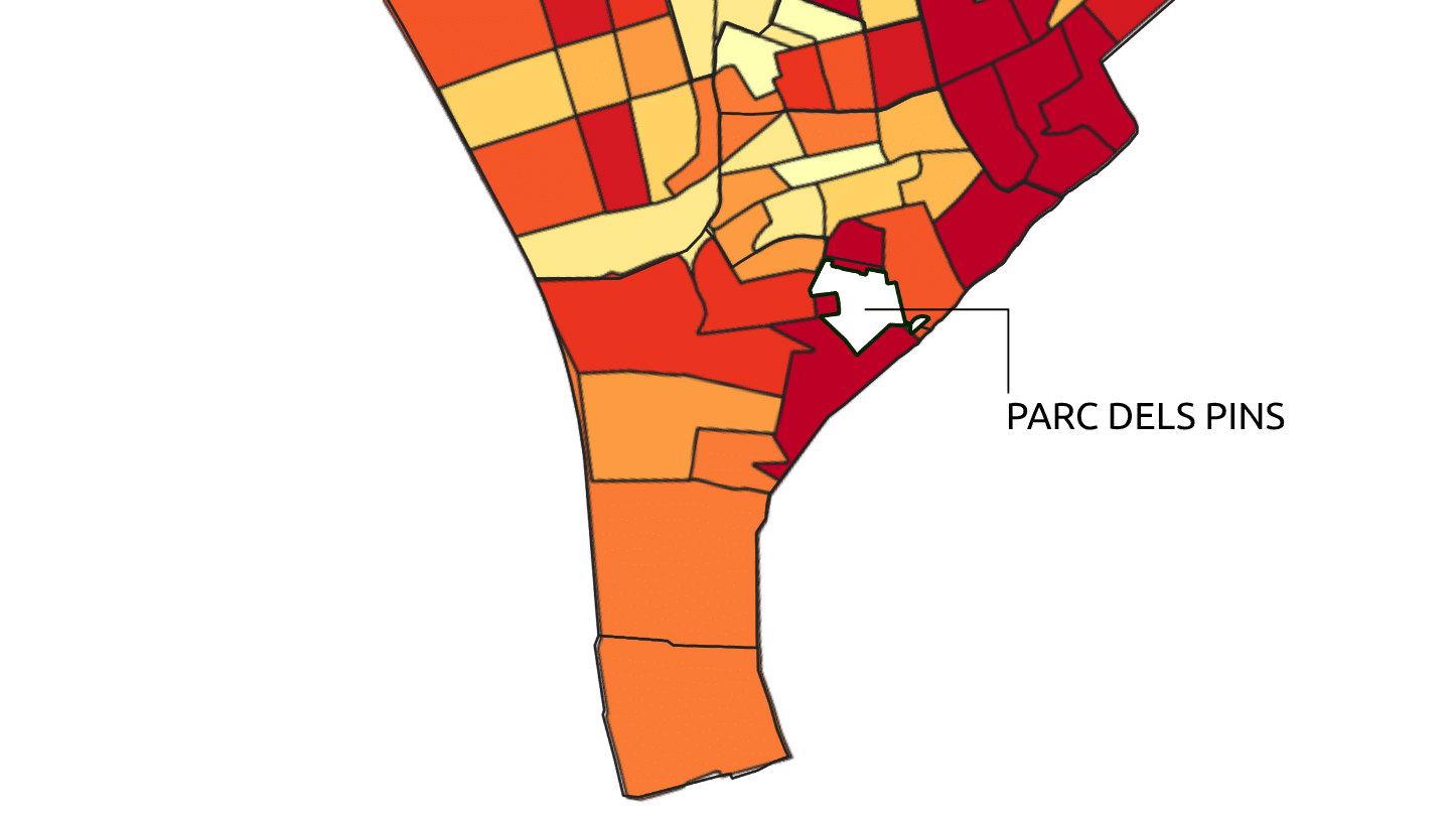
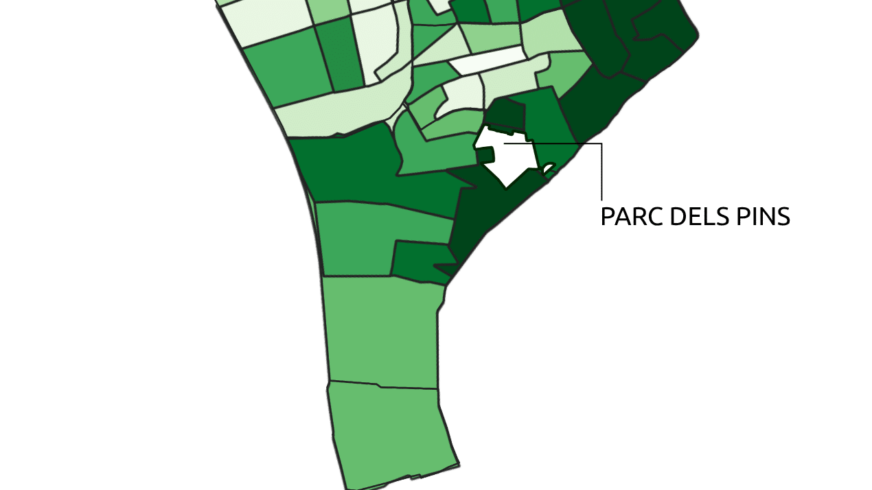
Before reaching Parc dels Pins, it is important to note a larger city initiative. Santa Coloma is working to link its green and public spaces to its two natural lungs: the Besòs River and the Sierra de Marina. Carrer de Monturiol, which connects the Besòs to Parc dels Pins, is part of this effort. Yet today, few would guess that this steep and narrow street opens to a 4.6-acre public park.
The park holds great value for the nearby community center. Conversations with local representatives revealed that the park struggles to bring people together. It often feels like a space to cross rather than to stay. Both the community and municipal officials wish to add greenery and new amenities. Their goal is to attract the diverse residents of Raval and the wider city. The steep topography poses a challenge, yet it also creates unique spatial qualities. Its curves, terraces, and openness can form a welcoming social hub for everyone.
The demographics of Santa Coloma de Gramenet
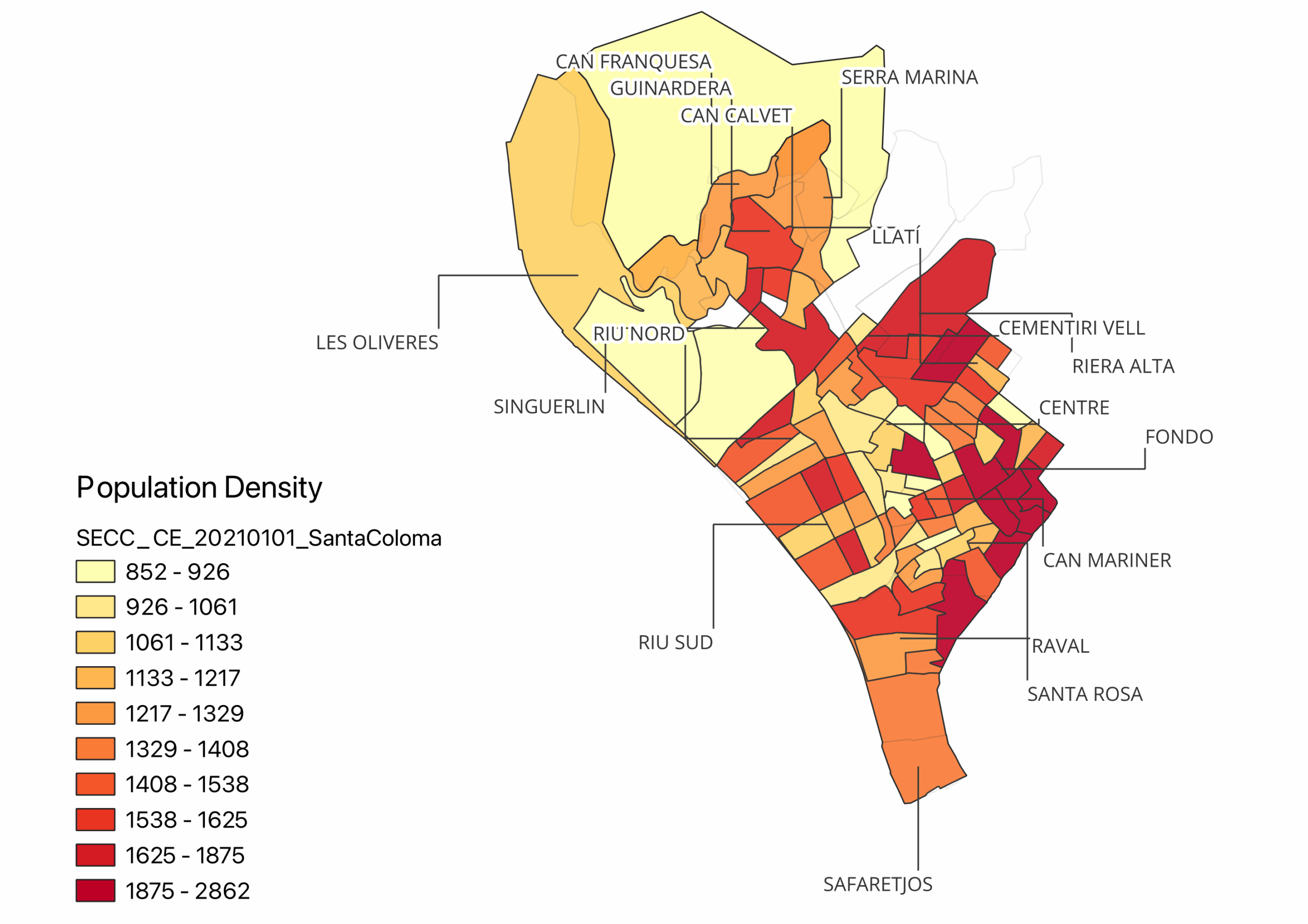
Santa Coloma de Gramenet has a rich history of migration. Since the late 19th century, it has drawn people from across and beyond Catalonia. In 1930, the city had 12,930 inhabitants. By 1975, it had grown to 137,000. Unlike Barcelona, its rapid expansion lacked a clear urban plan. As a result, Santa Coloma became one of the densest cities in the area, with about 17,272 inhabitants per square kilometer. Understanding this density was key, so data analysis followed.
Population density in Santa Coloma de Gramenet
INE – Spanish Statistical Office. (n.d.). Population and Housing Censuses 2021.
In 2021, data showed a strong population cluster in the Raval neighborhood. This makes Parc dels Pins a potential safe space for many residents — between 1,875 and 2,865 inhabitants per square kilometer. The study then focused on one specific group: children aged 0–19.
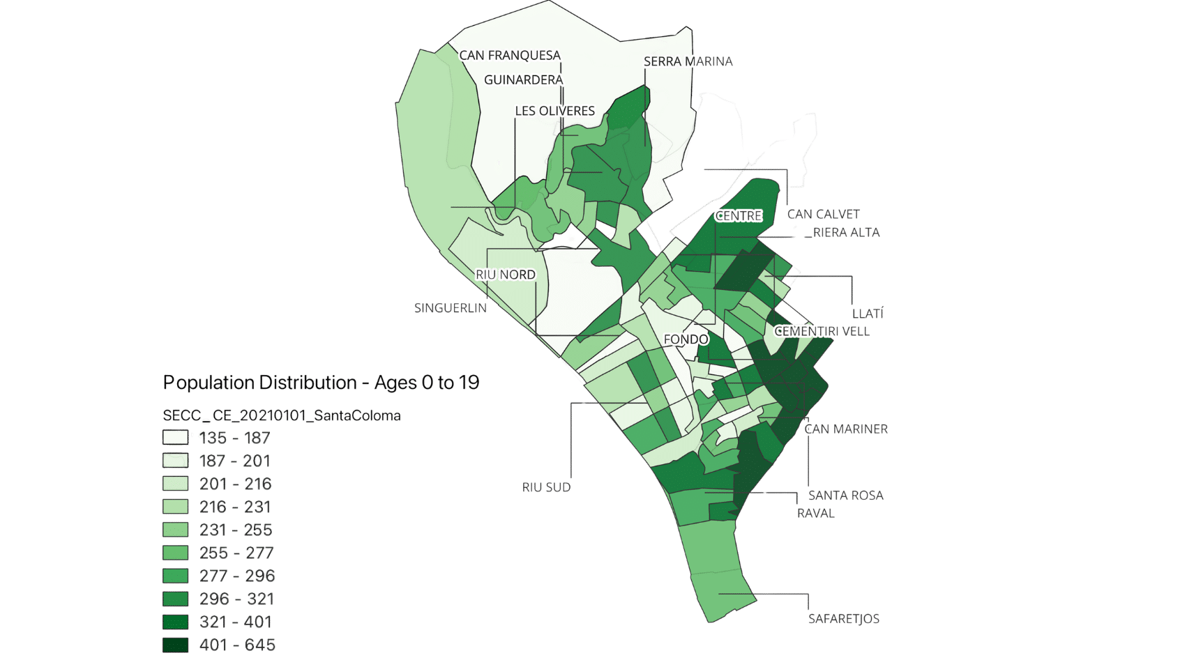
Population Density of Age Group 0-19 Years Old in Santa Coloma de Gramenet
INE – Spanish Statistical Office. (n.d.). Population and Housing Censuses 2021.
Maps revealed that most children also live in Raval. Between 401 and 645 children per square kilometer inhabit the area. This underlines the importance of creating safe and inclusive public spaces that support childhood development.
Diversity in Santa Coloma de Gramenet
INE – Spanish Statistical Office. (n.d.). Population and Housing Censuses 2021.
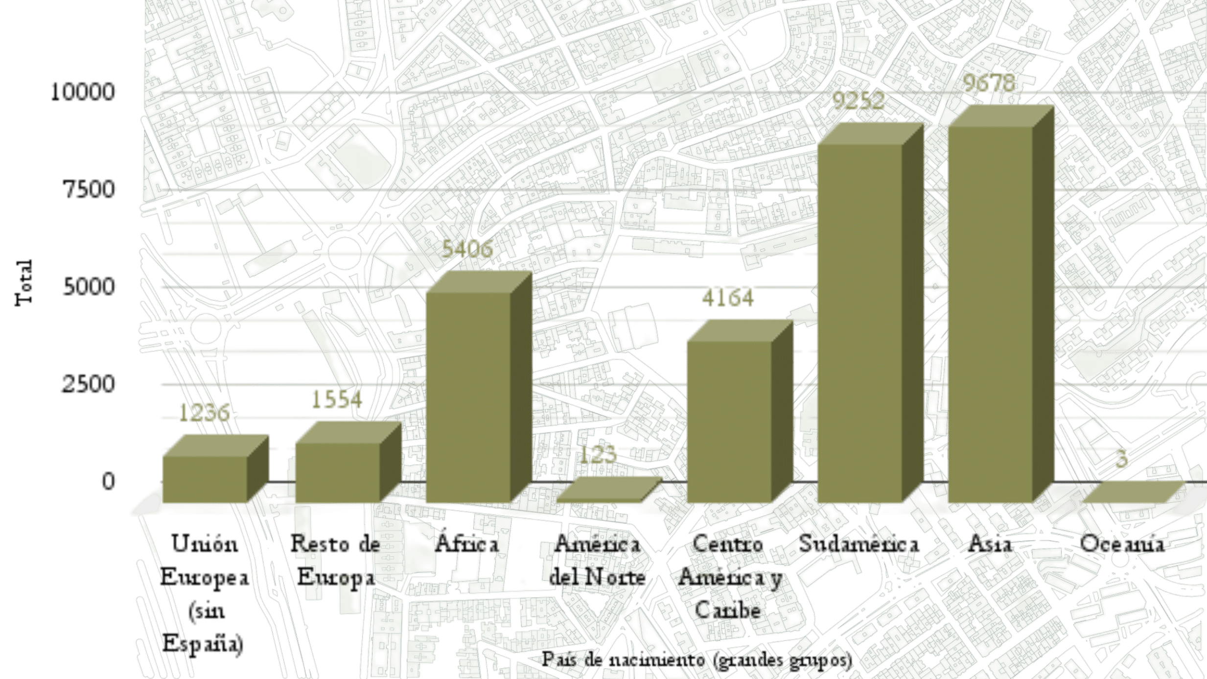
Santa Coloma also stands out for its diversity. Of its 118,000 residents, about 87,000 are Spanish nationals. The rest come from countries around the world. Second-generation children, balancing two cultures, often face added challenges. When housing and family conditions are unstable, public spaces that offer safety and belonging become vital. This is why Parc dels Pins plays such a key social role in the city.
Parc dels Pins and its surrounding institutions
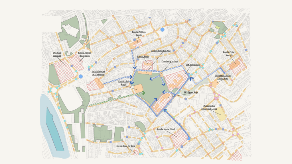
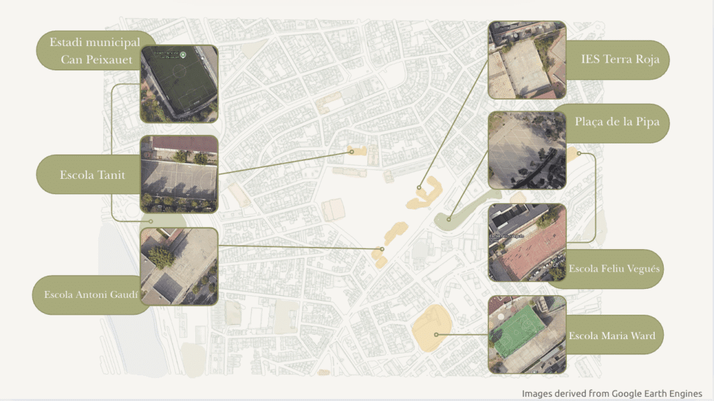
Despite its steep terrain, the park’s surroundings are full of educational and social activity. Ten schools lie within a 500-meter radius, from kindergartens to secondary schools. The community center Els Pins adds to this vibrant network. Around 3,000 students walk these paths daily. Although maps show patches of green, many are actually paved sports fields rather than true parks. Limited public transport and narrow, busy streets make the park harder to reach. Still, Parc dels Pins remains central to local life. It serves not just as an urban space, but as a place for learning, play, and community.
Primary target group
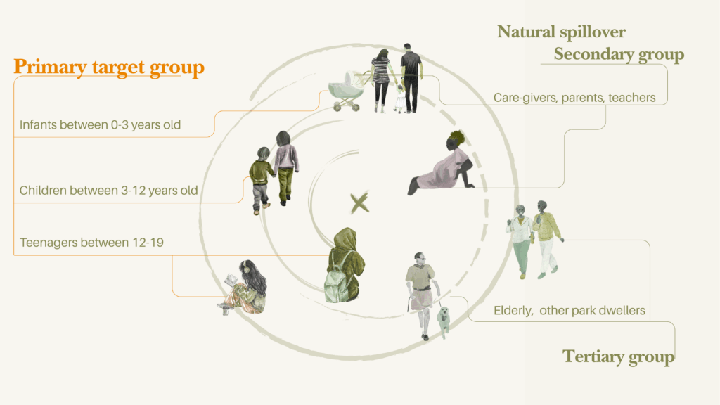
The main focus of this project is on young people. It aims to create an inclusive and safe environment for all ages — infants (0–3), children (3–12), and teenagers (12–19). A well-designed public space for children benefits the whole community. It directly supports caregivers, parents, and teachers, and indirectly improves the experience for the elderly and other park users.
Intentionality of Design
Elements of Design
Perceived Satefy of Children
Conversations with local residents revealed a shared concern: the neighborhood feels unsafe. The project seeks to change that perception. The goal is not only to improve the physical space but also to make it feel safe and welcoming for everyone. As Cities Alive notes, “The benefits of a child-friendly city go beyond children to add value to all citizens’ lives.” Following this idea, if a place feels safe for children, it naturally feels safe for all.
Social Inclusion of Children
The neighborhood is home to people from many cultures and nationalities. This diversity gives it a unique identity and a strong spirit of inclusion. The design celebrates this richness, aiming to build equity and belonging — starting with children. By creating places where all children can play, learn, and connect, the project hopes to nurture a more united and inclusive community.
Design Proposals
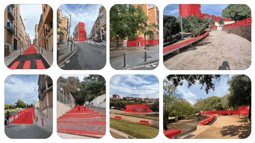
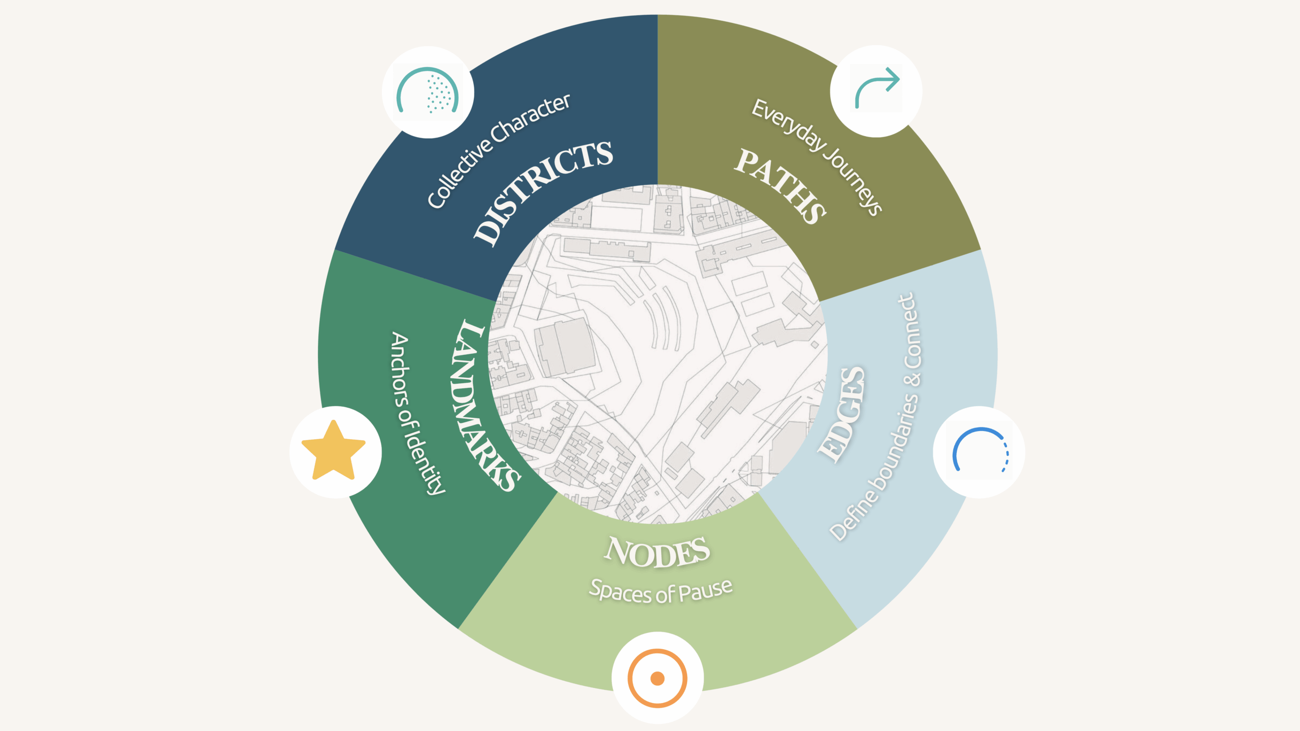
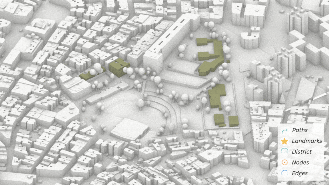
Paths
Many existing paths do not connect directly to the park, limiting accessibility. A new colorful and continuous pathway will guide users toward the park. It will also help shift negative perceptions of safety. Designed for the everyday journeys of children, the path aims to become part of their memories. It links schools, parks, and neighborhoods, fostering community connection.
Because of the area’s cultural and linguistic diversity, the signage system focuses on symbols rather than text. This universal visual language ensures accessibility for all, regardless of age or background.
Landmarks
Landmarks make orientation intuitive and playful. Children navigate through memories — a mural, a rainbow bench, a large tree, or a sculpture. These familiar features act as anchors, helping them recognize places and feel at home in their neighborhood.
Districts
Each district is designed to spark exploration, creativity, and learning. Sensory-rich environments invite children to touch, listen, and move through spaces filled with textures and natural sounds. These experiences nurture curiosity and cognitive growth through play.
The design encourages flexibility and imagination. Children are free to interpret spaces in their own ways. Interactive areas promote creativity, while community zones foster connection and shared experiences. Together, they build belonging, environmental awareness, and mindfulness in daily life.
Nodes
Nodes serve as active gathering points where paths and people meet. They bring children together through shared play and offer comfortable spots for caregivers. Throughout the day, shifting light and shadow create changing atmospheres, turning these nodes into micro-worlds of discovery and imagination.
Edges
Edges are where the park meets the city. Instead of hard borders, they form gentle transitions that invite people in. Benches, art, and playful details extend the park’s character into surrounding streets. These features continue the language of the paths, weaving the park’s identity into the neighborhood.
Redesigning Parc dels Pins: A Community-Driven Approach
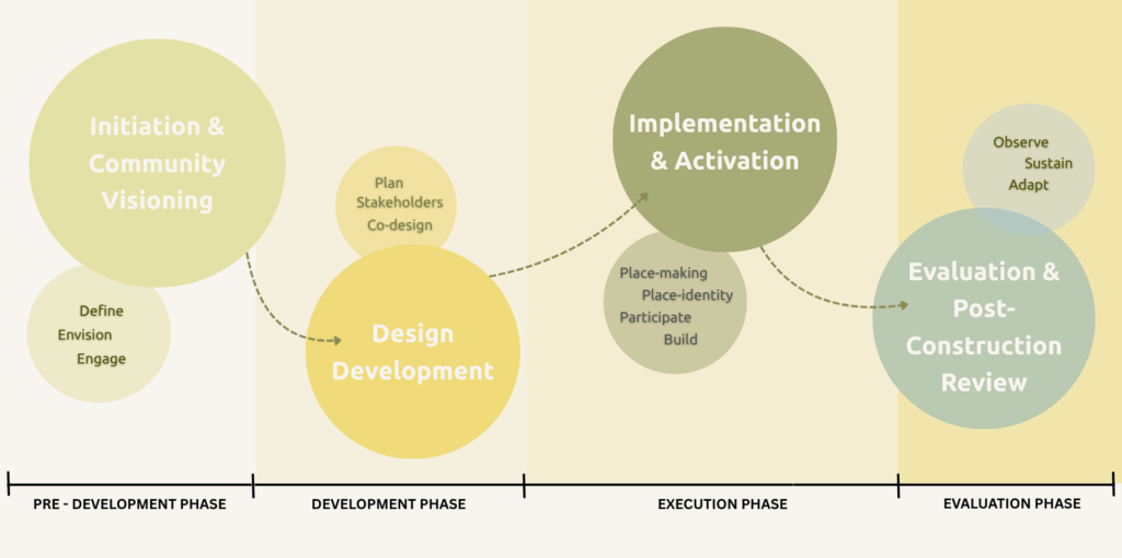
Redesigning Parc dels Pins: A Community-Driven Approach
Our project follows four clear stages — from vision to realization — ensuring that the redesign of Parc dels Pins remains deeply rooted in the community it serves.
1. Initiation and Community Visioning
A definition is established as a community, of a shared vision for an inclusive, child-centered park. The team studies existing conditions and engages the community through workshops, surveys, and school collaborations to understand local needs and aspirations.
2. Design Development
Insights gathered in the first phase are transformed into concrete proposals through co-design sessions with all stakeholders such as residents, local associations, and designers. Feedback during interim reviews helps refine the ideas into a feasible and community-aligned implementation plan.
3. Implementation and Activation
Construction unfolds in stages, prioritizing the most impactful areas. Community members participate in planting, art workshops, and co-building activities, creating a sense of ownership and connection to the renewed space.
4. Evaluation and Long-Term Stewardship
After completion, the park’s use is monitored and refined based on feedback. Continuous community involvement ensures adaptability, sustainability, and long-term care of the space.
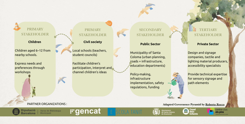
Finally, it is imperative to properly identify the stakeholders to engage in this transition. Image 5. outlines these stakeholders into 4 groups. This sectioning is based on empirical research by Roberto Rocco, dividing stakeholders, civil, public and private parts. These includes teachers, students, parents, as well as the municipality, libraries, school associations and so on. For the success of this project, all levels of the stakeholder groups must be invited to engage.
