
SITE SELECTION FACTORS
The site selected for the Recitying project is located in Parc Agrari del Baix Llobregat, a park just outside of Barcelona. This landscape initiative aims to transform abandoned crop fields into a significant and meaningful labyrinth park through the development of land art. The concept of land art is employed not only to rejuvenate the surrounding water features and facilitate interactions among different species but also to absorb noise from the nearby airport. This multifaceted approach leverages artistic expression to address environmental and ecological enhancements comprehensively.

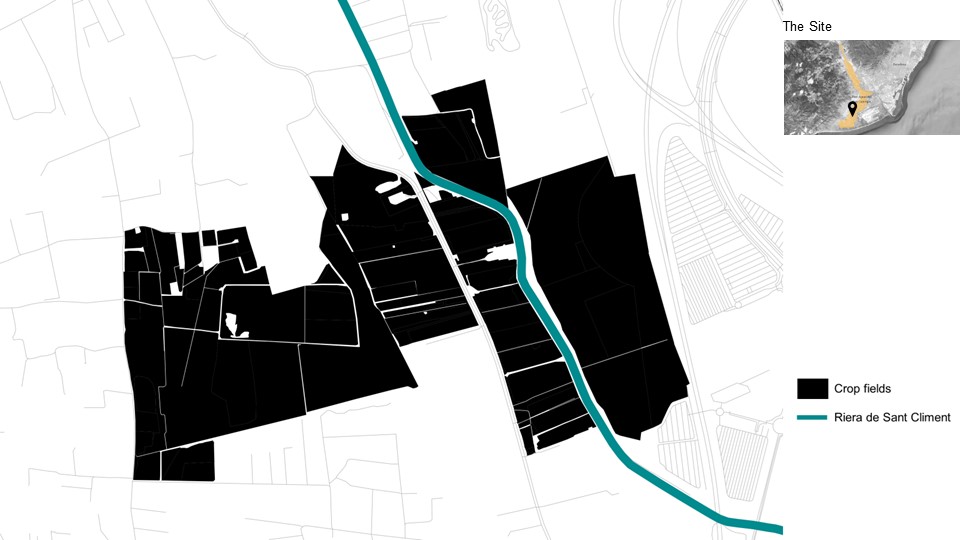
THE SITE
The site depicted in the map is characterized by its proximity to the “Riera de Sant Climent,” a river that flows through the area and later connects to the sea. This geographical feature is crucial as it offers significant potential for ecological rejuvenation. The project’s site spans various crop fields, shown in black, which are distributed along the river, highlighted in blue. The area designated as “The Site” on the map appears to focus on these fields and their immediate surroundings. The project aims not only to transform these abandoned agricultural fields into a dynamic land art but also to revitalize the riverbanks.
SITE CROP TYPES
The map identifies various types of crops and land use in the area surrounding the Riera de Sant Climent. Here’s a description of the different crop types labeled on the map, which can inform strategies for revitalizing soil health in the abandoned crop fields:
- TA – Arable Land: These areas are suitable for growing a wide range of field crops. Revitalization could include rotating legumes that fix nitrogen in the soil, thereby enhancing fertility.
- FY – Fruit Grower: These plots are currently or were previously used for fruit cultivation. To rejuvenate these soils, planting cover crops in the off-season can help prevent erosion and add organic matter.
- PR – Shrub Pasture: These lands are used as pastures with shrubs. These areas could benefit from managed grazing practices that promote soil health and prevent overgrazing.
- PS – Pasture: These areas are grassland pastures. Introducing rotational grazing and diverse grass species could help improve soil structure and fertility.
- TH – Garden: These small-scale gardens can be revitalized by incorporating compost and organic mulches to enhance soil nutrients and texture.
For a comprehensive approach to revitalizing the abandoned fields, a combination of these strategies tailored to each crop type’s specific needs could be very effective. Additionally, introducing permaculture techniques and encouraging biodiversity can help create a sustainable ecosystem that maintains long-term soil health.

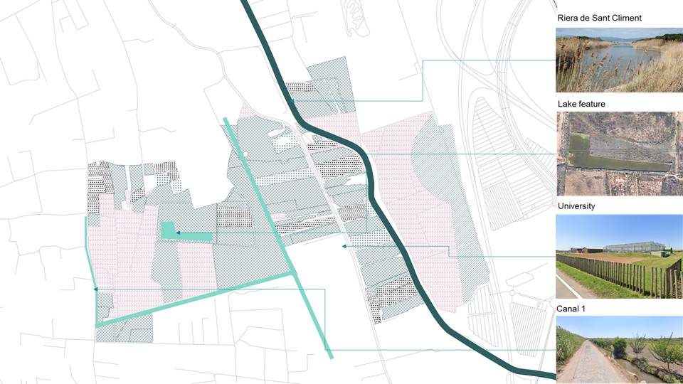
SITE FEATURES
The selected crop fields for the land art intervention are enriched with several features that enhance the site’s potential and appeal. These features strategically position the land art to serve the nearby communities, accommodate airport travelers, and attract visitors from adjacent cities like Barcelona. The existing canals, with their capacity for groundwater recharge and expansion into more extensive networks, add significant environmental value. Furthermore, the nearby university specializing in agrifood stands as a potential collaborator, poised to contribute expertise in maintenance and introduce innovative farming and gardening techniques. Additionally, the site is envisioned as a recreational space that benefits the university community, airport users, and others, creating a multifaceted and interactive environment.
SITE SOIL FEATURES
The site features two distinct soil types, each with unique characteristics and potentials for supporting different vegetation, which can be integral to the development of the land art project.
- Fluvaquent Typic-histic i Fluvaquent tipic:
- Characteristics: This soil type is known for its moisture regime, capable of supporting crops that can tolerate fluctuating conditions—specifically, periods of drought followed by water abundance. Such resilience makes it ideal for specific types of cultivation.
- Suitable Crops:
- Olive trees and Grapevines: These plants are notably drought-resistant and can thrive in the moisture-regulating properties of this soil.
- Herbs like Rosemary and Citrus trees: These require well-drained soil, which aligns with the periodic dry conditions of Fluvaquent soils.
- Artichokes and Legumes like chickpeas: These crops benefit from the soil’s ability to retain moisture during wetter periods, supporting their growth cycles.
- Xerofluvent oxiaquic i Xeropsamment oxiaquic:
- Characteristics: This soil type is typic and fluvaquent with a high content of organic matter, which suggests good fertility and drainage properties. The presence of organic matter is crucial for nutrient retention and water absorption, supporting diverse agricultural uses.
- Suitable Crops/Trees:
- Rice: Demands soil that can retain water, well-met by the high organic content which helps in maintaining moisture levels.
- Willows and Reed plants: These typically grow in wet environments, making the moist, richly organic soil a perfect match.
- Poplar trees: Thrive in moist, fertile soils, benefiting from the organic-rich characteristics of this soil type.
Understanding these soil dynamics is crucial for the site’s development into a land art project. Implementing agricultural strategies that align with the inherent qualities of each soil type can lead to sustainable cultivation practices that enhance the site’s ecological and aesthetic value. This approach not only supports the local biodiversity by providing suitable habitats but also integrates the land art with the natural environment, creating a landscape that is both functional and visually engaging.

CONCEPT FOR THE LAND ART
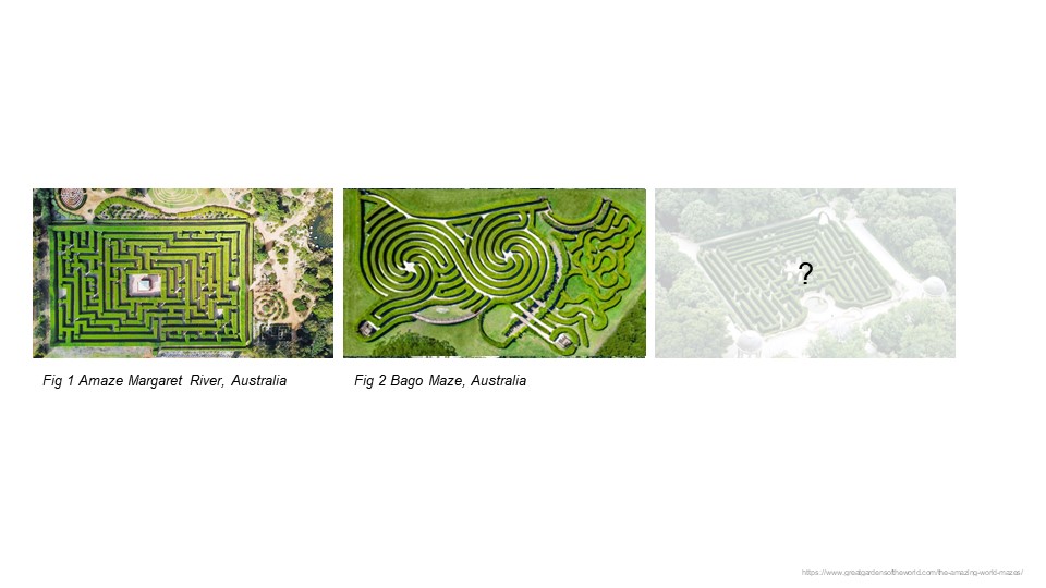
The concept for the land art as depicted in the images showcases two existing maze designs in Australia, providing a foundation for reimagining how such structures might be adapted to the selected site near Barcelona.
Figure 1: Amaze Margaret River, Australia – This design features a traditional labyrinth garden where paths lead to a central point. This concept focuses on guiding visitors through a defined journey, culminating at a central destination, which could symbolically represent a community gathering place or an area of significant natural beauty.
Figure 2: Bago Maze, Australia – Here, the design is more decentralized, offering a reinterpretation of the classic labyrinth. It suggests multiple entry and exit points and a less linear experience. This design could be seen as promoting exploration and discovery over a singular goal, potentially reflecting the diversity of the site’s users and uses.
Proposed Concept for the Third Image – For the new concept of a labyrinth garden, envisage a hybrid design that incorporates elements of both traditional and decentralized mazes. This labyrinth could integrate various crop fields and garden spaces, forming an eco-friendly and interactive land art piece. The design would cater not only to the aesthetic and recreational needs of nearby communities, the transient airport passengers, and the local university population but also to the ecological needs by enhancing biodiversity.
This new labyrinth would be more than just a path or a journey; it would be a living, growing entity that changes with the seasons, supports local wildlife, and provides educational and recreational opportunities. It would be a place where the lines between art, agriculture, and conservation blur, creating a unique space that serves multiple purposes.
This concept would not only beautify the area and provide functional benefits but also create a landmark that draws visitors and enhances the cultural and ecological fabric of the region.
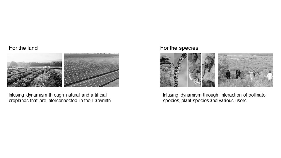
INTERACTION BETWEEN THE LAND AND THE SPECIES
The provided image conceptualizes the land art project with a dual focus: one on the land and the other on the species, demonstrating an integrated approach to land management and biodiversity.
For the Land:
The image illustrates two types of crop fields: one natural and the other featuring artificial arrangements, possibly solar panels integrated within crop spaces. This dual representation symbolizes the infusion of dynamism through the interconnection of natural and technologically enhanced landscapes within the labyrinth design. The integration of solar panels amidst the crop fields suggests a commitment to sustainable practices and renewable energy, reflecting a modern approach to agricultural land use that not only supports crop production but also contributes to energy generation.
For the Species:
This part of the image highlights the biodiversity aspect of the project, showing various pollinators and wildlife along with human interaction. The images of different animal species — likely including pollinators like bees and birds alongside other wildlife — emphasize the labyrinth’s role in supporting and enhancing biodiversity. The inclusion of people in the environment suggests that the labyrinth will also serve educational and recreational purposes, providing a space where visitors can learn about and engage with nature.
Integration of Concepts
The labyrinth is conceptualized as more than just a physical pathway or artistic installation; it is envisioned as a living, breathing ecosystem that connects the land’s use with the natural world. By merging agricultural practices with ecological conservation, the project aims to create a sustainable environment that supports both human and wildlife needs. The labyrinth’s design not only encourages ecological interactions but also educates and involves the community, making it a dynamic space for learning, conservation, and sustainable living.
This approach highlights a forward-thinking design that balances functional land use with ecological and community engagement, aiming to create a multipurpose landscape.
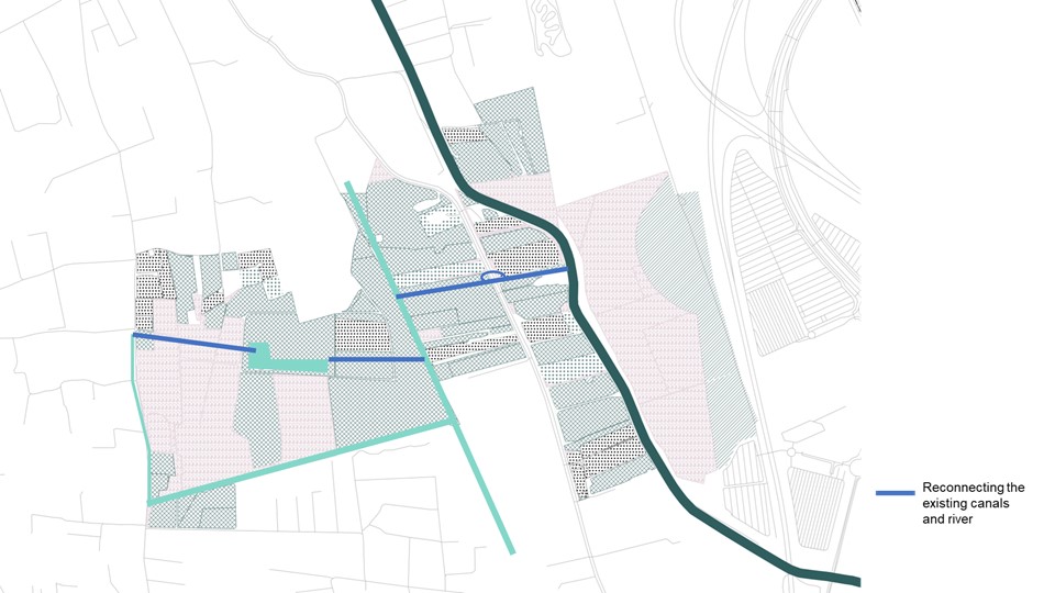
INTERVENTION 1- RECONNECTING THE EXISTING CANALS
The first intervention of the design proposal focuses on reconnecting existing canals with the nearby river to enhance the landscape’s hydrological integration. This intervention is marked by the blue lines on the map, indicating where the canals will be linked to the main river flow. The aim is to improve water management and accessibility throughout the area, which could benefit agricultural activities, enhance local biodiversity, and increase the ecological health of the region. By reconnecting these waterways, the project seeks to create a more cohesive and sustainable water system that supports both the environment.
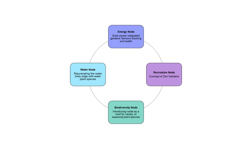
INTERVENTION 2- INTERCONNECTED NODES
The second intervention outlined in the design proposal involves establishing interconnected nodes, each designed to fulfill a specific ecological or recreational function:
- Energy Node: Integrates solar power into the gardens, equipped with sensors to monitor soil health, thereby promoting sustainability and technological innovation in environmental management.
- Water Node: Focuses on rejuvenating the edges of water bodies with appropriate water plant species to enhance aquatic ecosystems and improve water quality.
- Biodiversity Node: Introduces a variety of seasonal plant species to create a habitat that supports diverse wildlife and plant life, strengthening the site’s ecological fabric.
- Recreation Node: Incorporates the concept of Zen gardens to provide a tranquil and aesthetic environment for relaxation and contemplation, enhancing the recreational value of the area.
Each node is interconnected, suggesting a holistic approach to land use that balances ecological integrity with human enjoyment and sustainable energy practices.
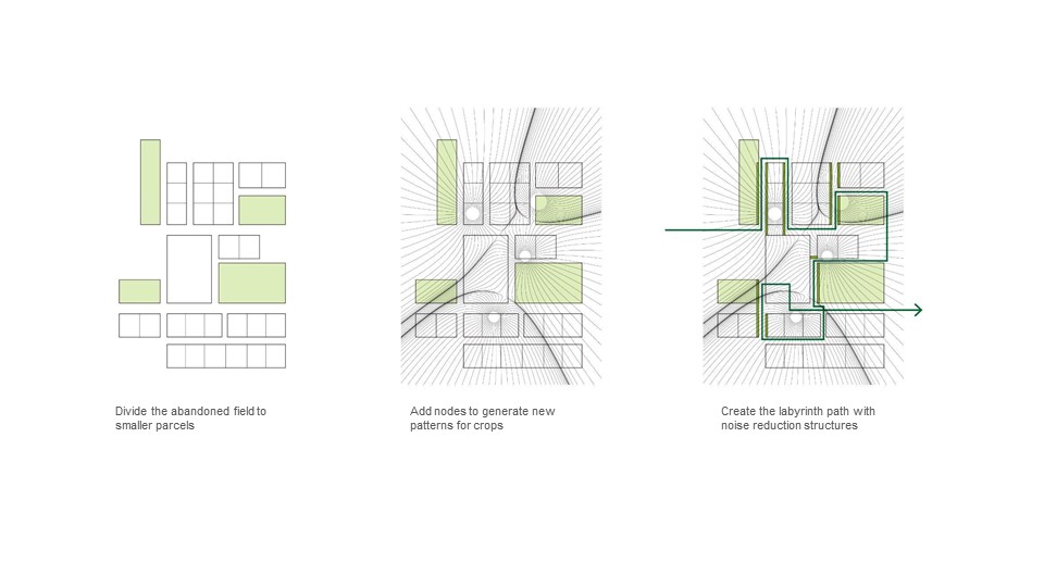
INTERVENTION 3- THE LABYRINTH GRID
Intervention 3, titled “The Labyrinth Grid,” is a systematic approach to revitalizing an abandoned field through structured land use. The process begins by subdividing the field into smaller, manageable parcels. This division allows for more controlled agricultural practices and the introduction of diverse crop patterns. Following this, nodes are strategically added to create new patterns that optimize the use of space and resources. Finally, the design integrates a labyrinth pathway that incorporates noise reduction structures, enhancing the aesthetic and functional appeal of the area. This pathway not only serves as a tranquil walking route but also mitigates noise pollution, potentially from nearby urban or airport activity.

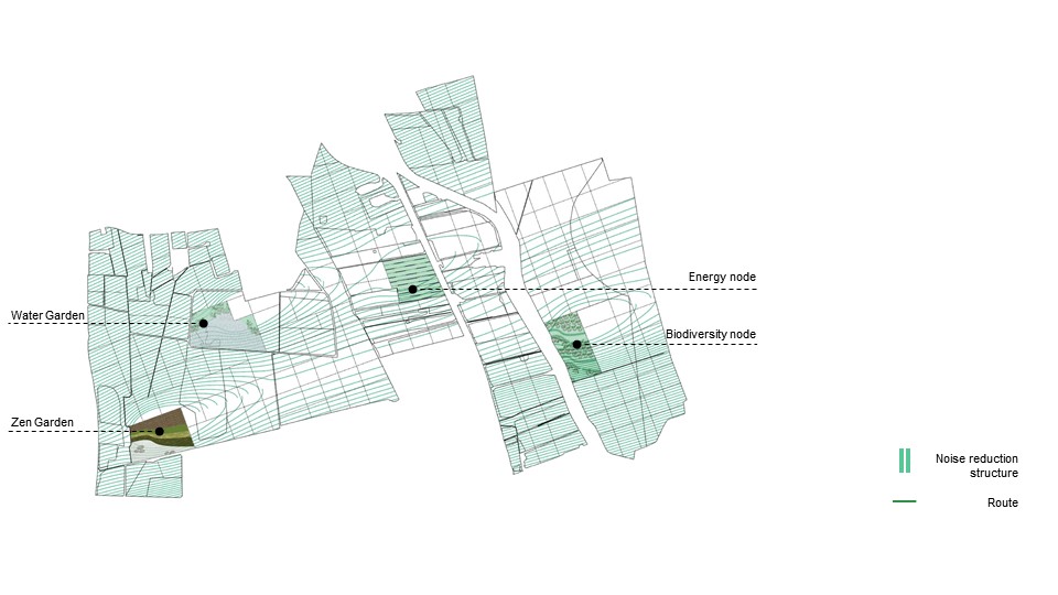
THE MASTERPLAN
The final masterplan depicted in the image is a comprehensive and strategic layout that integrates three key interventions: water management, energy sustainability, and biodiversity enhancement, along with recreational spaces.
Components of the Master Plan:
- Water Garden: Positioned strategically within the site, the water garden focuses on enhancing water ecology and aesthetics. This intervention serves to beautify the area while also promoting water conservation and supporting aquatic life and aquatic species.
- Zen Garden: This element introduces a serene and contemplative environment, reflecting the recreational node from the second intervention. The Zen garden provides a tranquil retreat for relaxation and reflection, promoting mental well-being.
- Energy Node: This is clearly marked on the plan and is dedicated to integrating sustainable energy solutions, likely involving solar power, into the landscape. This node likely includes technological elements like sensors to monitor environmental conditions, contributing to the overall efficiency and sustainability of the area.
- Biodiversity Node: Positioned to foster ecological richness, this node focuses on increasing the variety of plant and animal life within the area. It aims to create a thriving ecosystem that supports both endemic and migratory species, enhancing the site’s natural diversity.
- Noise Reduction Structures: These are strategically placed along the routes to mitigate noise pollution, possibly from nearby urban or industrial activities. Their placement ensures that the tranquility of the gardens is preserved, enhancing the visitor experience.
- Routes: These are designed to facilitate easy and accessible navigation throughout the site, connecting different nodes and features. They ensure that all areas are reachable and enjoyably navigable for visitors of all abilities.
Overall, the master plan is designed to be a cohesive and sustainable landscape that not only meets ecological and recreational needs but also integrates modern energy solutions. It aims to serve as a model for how abandoned or underused lands can be transformed into productive and beneficial spaces for both the community and the environment.
THE BOULEVARD PATHWAY
The diagram showcases a strategic aspect of the master plan’s design, integrating a noise-absorbing wall within the labyrinth pathway, which serves a dual function within the landscape. This pathway navigates through various designated spaces of the master plan, enhancing both functionality and aesthetic appeal. Designed to reduce noise pollution from nearby airport activities, the wall absorbs sound waves, particularly those between 500 Hz to 2 kHz, making the surrounding environment more pleasant for occupants.
Moreover, the pathway features a dual-function shading device that not only assists in noise reduction but also supports biodiversity by hosting a variety of plant species on its opposite side. This integration enriches the ecological diversity and visual appeal of the area, fulfilling the master plan’s goal of creating an interactive, sustainable landscape that benefits both human users and local wildlife. The comprehensive design ensures the labyrinth is both a tranquil passage and a vibrant ecological corridor.
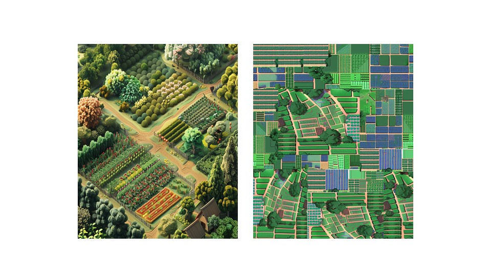
THE CROP MAZE
The visualization showcases two distinct crop maze designs. The first image presents a traditional garden maze, beautifully landscaped with a variety of vegetation including neatly arranged flower beds, shrubs, and trees. This setup not only enhances aesthetic appeal but also serves recreational purposes. The second image introduces a more modern approach, integrating agricultural plots with solar panels, suggesting a dual-purpose strategy of crop production alongside renewable energy generation.
BENEFITS OF REACTIVATING CROPS
The proposal is intricately designed, promoting not just biodiversity and sustainability but also creating interactive and engaging spaces for visitors, blending agriculture with leisure and environmental stewardship.

