
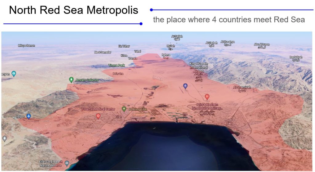
North region of Red Sea. Egypt, Israel, Jordan, Saudi Arabia
Concept statement
North Red Sea Metropolis (NRSM) is a hypothetical metropolis that combines towns and industrial areas in 4 neighboring countries of the North part of the Red Sea: Egypt, Israel, Jordan, and Saudi Arabia. Considering the vicinity of Neom city, the Suez sea trade route, and the popular tourist destination of the Red Sea, located in the middle of the triangle of movement of people and goods between Asia, Africa and Europe, NRSM is envisioned to develop the unique case of cross-border cooperation between 4 countries, improve local mobility and ensure sustainable development of the region.
- Key success factors for the NRSM development consider:
- existing urban nodes and communities with old urban history,
- international high-capacity trade routes,
- Interconnectivity with the tourism industry and transit passenger hubs,
- multiculturality.
Action plan for North Red Sea Metropolis
- Global context study
- Historical background
- Evaluation of existing urban centers as future TODs (urban localities)
- Evaluation of perspective TODs (urban localities)
- Study of green-grey infrastructure (green belts, transport corridors)
- Study of trade routes, local economics, demographics
- Study of urban fabrics, physical borders, and bioclimatics
- Cross-sector analysis and evaluation of a metropolis corso and fabric
Global context
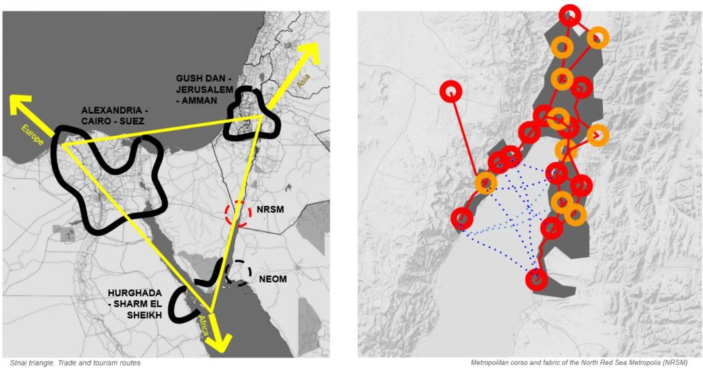
Sinai triangle designates metropolitan clusters with high global connectivity but quite low local interconnection. North Red Sea region is located on the line of the Sinai triangle that connects metropolitan areas of Gush Dan – Amman, and the seasonal metropolitan area of Hurghada and Sharm El Sheikh (soon expected to be supplemented with Neom city), and holds sufficient economical potential.
In the broader global context, the Sinai triangle can be conceived as a territorial diamond – an urban ecosystem of innovations, and NRSM can be considered a vital part of this ecosystem.
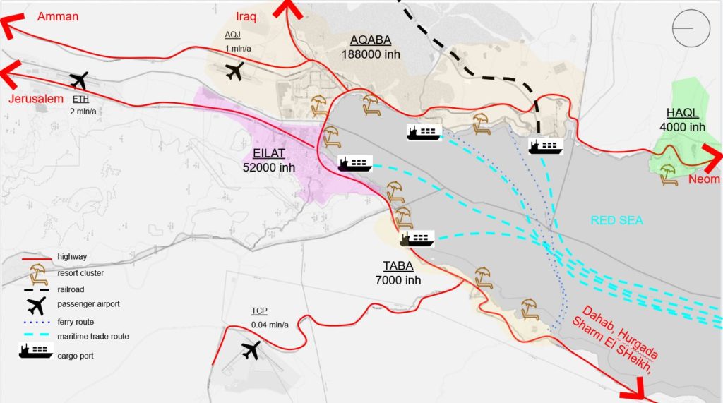
International sea trade
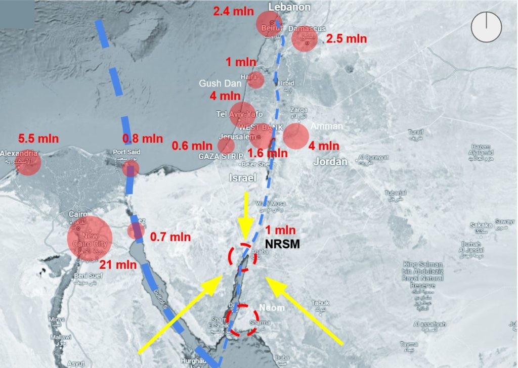
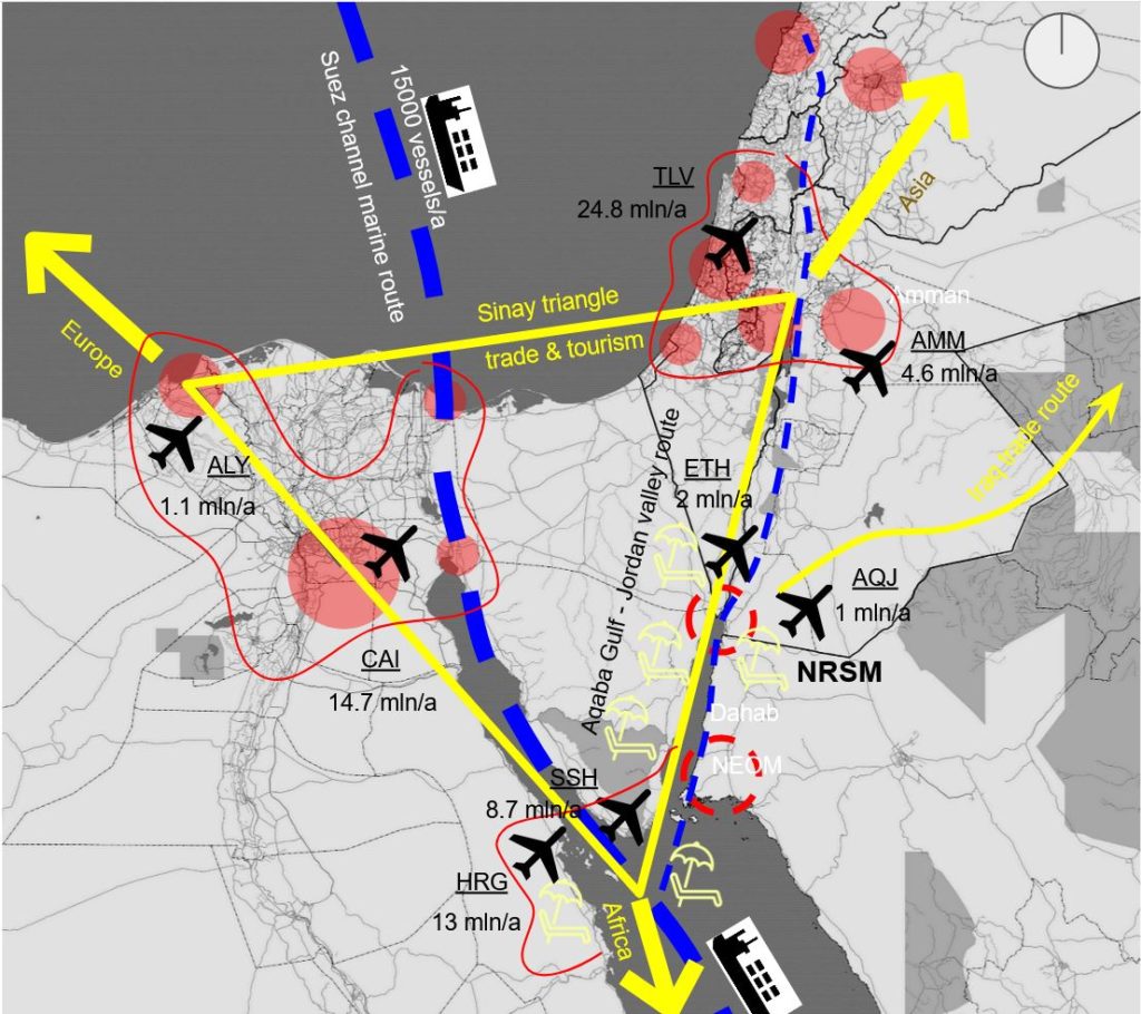
Since ancient times Aqaba gulf and the towns around it were included in trade routes of the Maritime Silk Road. Nowadays, in the 21st century, the North seashore of Aqaba gulf has several ports serving as important knots of trade routes. Aqaba port has a cargo capacity of 20 mln t/a, a deep cargo port, and a special economic zone (ASEZ) used as the gateway for the transit corridor to Iraq (port + railroad). Eilat port transfers 2.6 mln t/a of cargo. Suez channel serves 15000 cargo vessels per annum and reached a record high transit of 1260 mln tons in 2021. Considering the global demand for international cargo transit ports of NRSM have large perspectives as a modal point of train/sea trade.
Air routes
Airports of Tel Aviv and Amman (TLV + AMM) serve 29.4 mln per annum. Airports of Sharm El Sheikh and Hurghada (SSH + HRG) = 21.7 mln/a. Airports of Alexandria and Cairo (ALY + CAI) = 15.8 mln/a. Located in between of TLV + AMM and SSH + HRG, airports of Eilat and Aqaba (ETH + AQJ) = 3 mln/a potentially. The airport of Taba (TCP) has quite a low turnover of circa 40 000 passengers per annum. Potentially the triade of airports ETH + AQJ + TCP may serve redirected tourist flows from overcrowded CAI and TLV airports.
Tourist destinations
Hurghada, Sharm El Sheikh, Dahab reached a maximum of 22 mln tourists per annum, Jordan’s tourist attractions of Petra, Ancient Nabatea – 6.7 mln tourists/a, Jerusalem, Ancient Judea and Palestine – 4.5 mln tourists/a. Situated between them NRSM is deemed to be rethought as a new transfer point for tourists as well as a provider of certain tourist attractions within its own metropolitan area.

Source: Adapted from Martin Jan Mansson. The Geography of Transport Systems
Historical background
The urbanized history of the North Red Sea region took its pace in 7000 BC, from the first dated settlement that was called Eloth. The map of Strabo of 15 AD describing the Roman Empire contains the town of AElana. In the Medieval Ages, it took an active role in the Maritime Silk Route. The industrial history of the region holds the most ancient copper mining site of Human history in Tymna Valley operated since 5 millennium BC. Different historical layers contain the legacy of ancient Edam, Judea, Egypt, Nabatea, and Umayyad Caliphate.
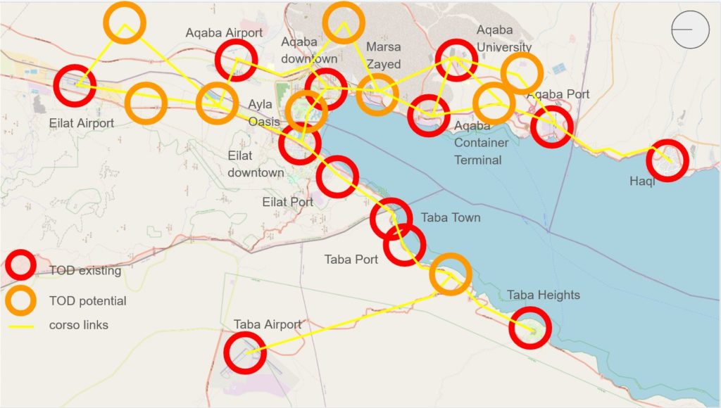
Analysis of TOD nodes (urban localities)
Analysis of TOD reveals nodes clustered around town centers, transport infrastructure, university campuses and the last ambitious development projects. Interconnecting existing nodes interpolate focal points for perspective TOD’ nodes.

Featured TOD nodes represent different urban densities and functional diversity. 40% of existing TODs are concentrated within the part of Jordan.
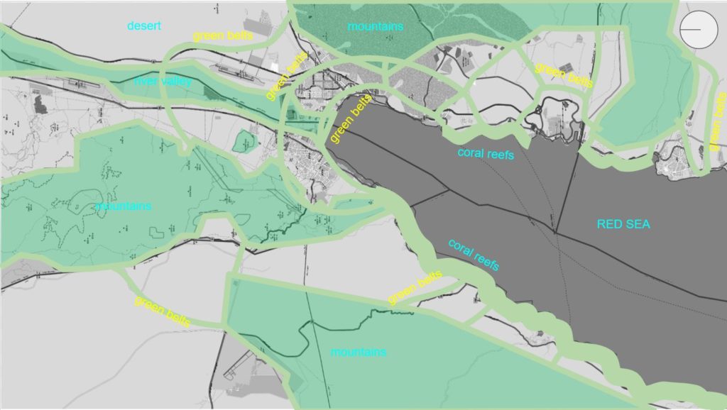
Green-grey infrastructure
Green infrastructure encompasses the wildlife migration corridor via Jordan valley, involving mountains, wetlands, and coral reefs that partially already have conservation status. The hypothesis envisions a connection with nature by rewilding green belts that are intended to become the cradle for the restored biodiversity of the region.
Grey infrastructure has strong trade route connections while public transit still has weak development. A metropolitan strategy for rail and water connection is envisioned to improve the situation sufficiently and connect 3 airports, 4 ports and 4 towns, 22 urban localities in total.
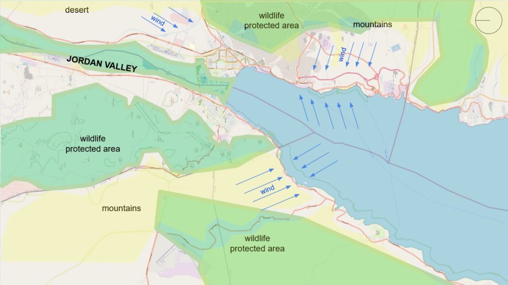
Wedged between mountain gorges and deserts NRSM has preferable grow potential along the Sinai triangle’s side – the Dead Sea – Red Sea. Local bioclimatic conditions includes seasons of sand storms and strong winds from mountains towards the sea, and should be considered in urban development. Water scarcity is another important issue to be addressed by planners.
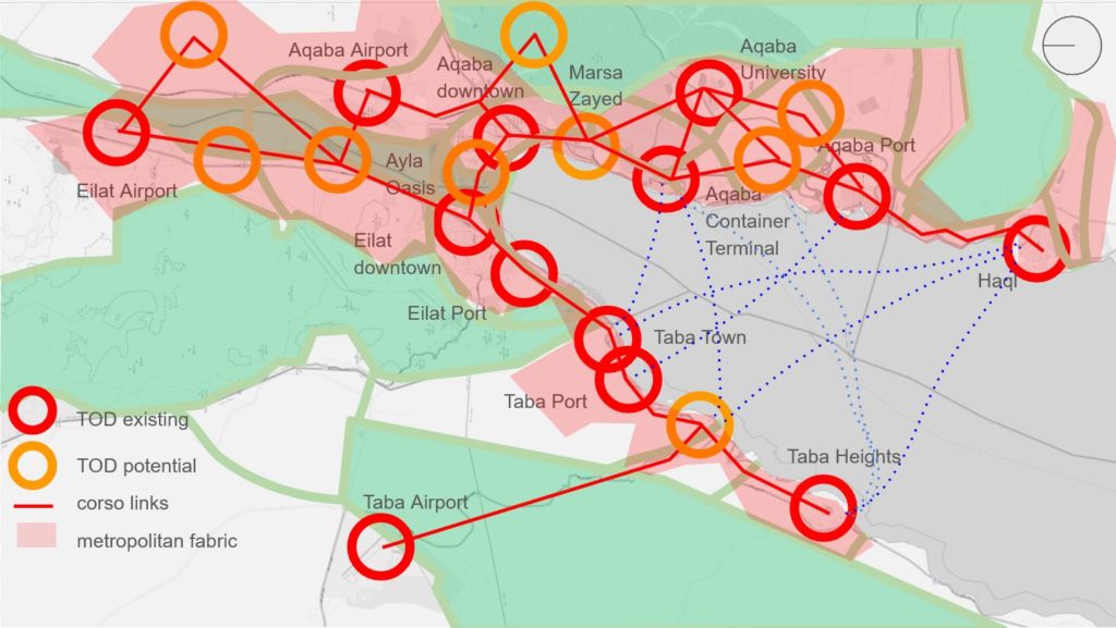
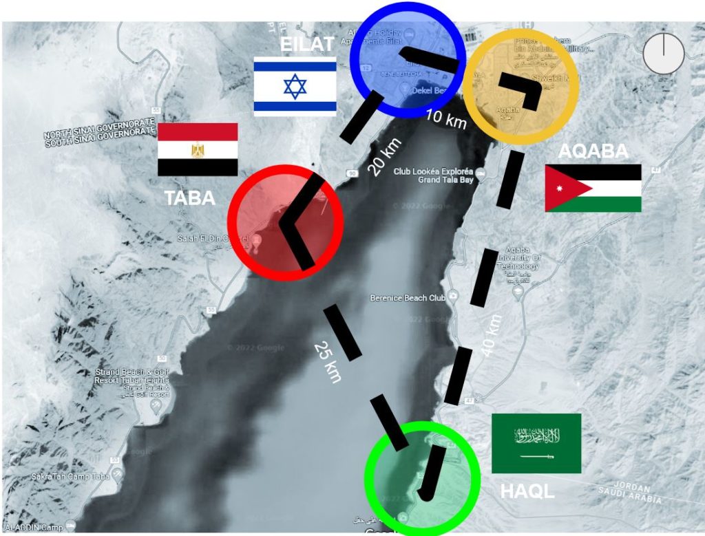
The Metropolitan area of North Red Sea Metropolis covers an approximate rectangle 30 by 15 km, although may include several branches towards airports and remote urban clusters.
The hypothesis of NRSM studies the possibility of the amalgamation of existing separate urban units in border-cross regions into metropolitan structures with common facilities.
