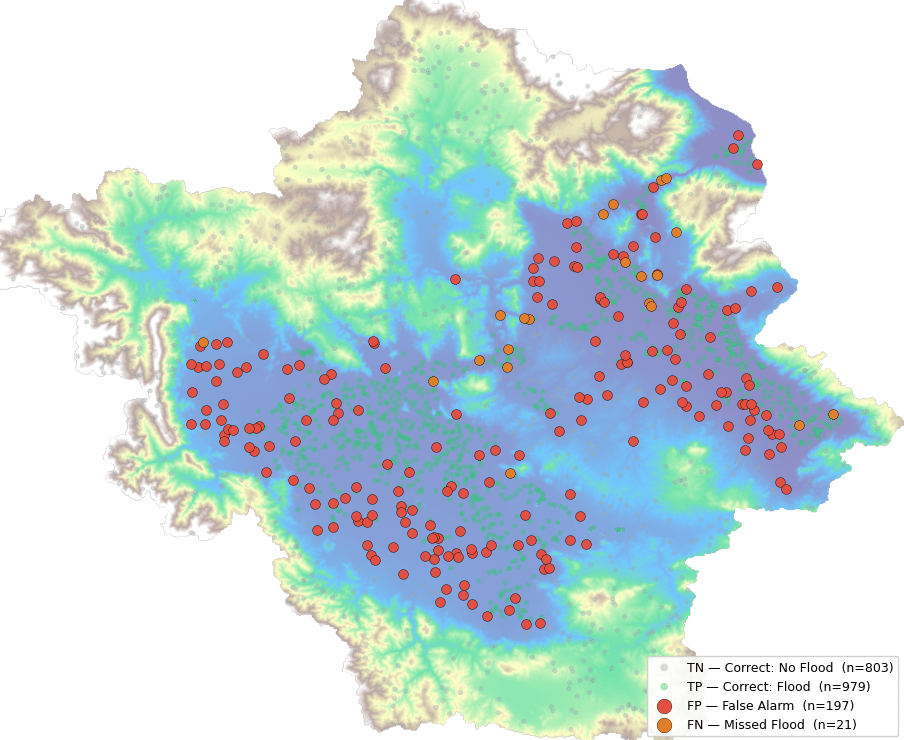
Dataset Our database contains more than 181,000 rows, each with comprehensive information. The primary database includes 17 variables, though not all are necessary for our analysis. The most crucial data points are location (latitude and longitude), type of food establishment, type of inspection, inspection results, and risk level. As the person who uploaded the database … Read more

Fields at Play

Fields at Play identifies the value of gender inequality in Olympic infrastructure and proposes to leverage the derived $12.6B Olympic gender gap in sports facilities to fund the revitalization and ongoing program of reliable, safe, and comfortable spaces for women at risk of gender-based violence. Understanding the purpose and outcomes of Olympic infrastructure strategies in … Read more

Kyoto Blossoms & Tourism Machine Learning

Project Focus For our Graph Machine Learning project, wanted to look at the city of Kyoto and Tourism Behavior around Cherry blossom patterns. Specifically, we set out to find out how cherry blossom patterns might affect the behavior and walking paths of tourists within the city. Data Sets We started by collecting our data sets … Read more

Riverine Alliances

The intensification of human activities has transformed river basins, characterized by the loss of natural floodplains, an increase in impermeable surfaces, and the escalation of surface runoff. This thesis explores the importance of tailoring flood prevention strategies to upstream conditions to aid in flood risk management for downstream urban areas. Specifically, it presents an incentive-based, … Read more

Predict Yelp Ratings based on Urban Data using GML

Hypothesis The goal of this research was to investigate if open spatial data could predict Yelp ratings utilizing graph machine learning (GML) methods. We hypothesize that urban phenomena, events, and objects will indicate customer reviews and popularity, and therefore, could be used predict ratings. In particular, we perform edge classification using the DGL library. For … Read more

Metro Station Prediction in Stockholm

This post describes the development of a method to predict metro station locations using Graph Neural Networks (GNNs). Our journey began with a challenge familiar to urban planners: how to strategically place new metro stations to optimize transportation networks. In this case the city of Stockholm was used as testbed. The Challenge of Data Imbalance: … Read more

100-Year Flood Risk Road Intersection Classification

Flood Risk Classification

Beginnings Our project’s concept is to develop a classification model that identifies street intersections (graph nodes) in Stockholm, Sweden, susceptible to flooding during a 100-year flood event. Based on our initial research, we found that graph machine learning operates at three levels: the graph, its edges, and its nodes. With access to a 100-year flood … Read more

Tiny Topographies

Optimizing Bar Buildings for Sunlight and Pathways The aim of this project was to design a typology of housing is needed that resembles small, artificial terrains. The Bar Building typology will have set of long, dense buildings that will mimic the form of a topography. The forms will need to be optimized to allow for all the … Read more

Forms of Inadequacy in Dakar

Abstract Dakar is Senegal’s capital city and rapidly urbanizing economic center. Today, Dakar’s urban area is home to 3.54M people, half of Senegal’s population, and generates 55% of the Country’s GDP. This growth is artificially constrained by an urban growth boundary, where new homes are informally built, and due to the city’s topography, a peninsula … Read more

Rising Waters

The year is 2100. Latin America is sinking. Due to global warming the polar icecaps have almost melted completely. In addition the increased temperature has caused the global water mass to expand by almost 1%. As a consequence sea levels are rising at unprecedented levels globally. The coastline in South America is hard-hit by these … Read more

Drop by Drop – Simulate erosion

Introduction Fascinated by the formation of landscapes through geological processes, I wanted to develop an interactive tool that simulates the effects of erosion on a virtual terrain. The goal was to both illustrate how erosion works and to create an experimental playground for designing one’s own landscape forms. The development utilized VUE, ThreeJS, and Rhino.Compute. … Read more

Tracking Cross-Border Monetary Flows to measure Geopolitical Insecurity

Creating a streamlined pipeline to visualize and extrapolate financial data enabling a correlation with spatial geo-specific information. The World and all countries alike have been increasingly more susceptible to events and developments in the geo-political theatre. It is not surprising that the world’s top two economic and military superpowers play a pivotal role in this … Read more

Ideals Along Lines of Conflict

The killing of Nahel Merzouk was not an accident. The 17-year-old French Algerian boy was killed where the potential for conflict is high, in Nanterre. A young Muslim in a yellow Mercedes along the western Champs-Élysées unfortunately made Nahel a prime candidate for police violence resulting in death. His death brought about a week of … Read more

Confronting Forms of Erasure

History is not always written in neat paragraphs and grand monuments. Sometimes, the most important stories are the ones left untold. The ones silenced, forgotten, or deliberately erased. In 1994, over a period of 100 days, the Rwandan genocide took place. Hutu extremists; fueled by ethnic hatred and political manipulation, sought to eradicate the Tutsi … Read more

Darien: Closing the data Gap

Imagine a massive highway stretching from Alaska all the way down to the tip of Argentina. That’s almost possible through the Pan-American Highway, except for one crucial interruption: the Darien Gap. The Darien Gap is a sprawling, dense jungle separating Panama and Colombia, an obstacle that breaks the otherwise continuous highway. But the Gap isn’t … Read more

‘Gotta Catch ’em All’

Co-design & Experience Platform for Public Art as part of Data, Art and the City (5-day workshop led by Leyla Saadi) Adapted from Pokemon-Go, we propose the development of a place-based app that pops the City of Toronto’s public art scene, drives interest and support for local public art and artists, and co-designs future public … Read more

Coltura

Introduction Milan, Northern Italy’s epicenter, confronts economic and environmental challenges rooted in a shift from agriculture to manufacturing. To secure its future, Milan invests in knowledge, tourism, and place-based innovation, relying on revenue from high-income foreigners, students, and the European Union. Strategic efforts to transition to a green economy focus on renewable energy, waste reduction, … Read more