IAAC’s Master in AI for Architecture & the Built Environment is a unique program oriented towards leading the change in decarbonising human activities and crafting a more sustainable, resilient future urbanisation for our planet. Through an innovative curriculum deeply rooted in AI applications, the program pioneers novel AI-driven solutions that not only respond to the pressing challenges of our time but also set a new standard for environmentally and socially conscious co-design and planning. The Master in AI for Architecture & the Built Environment is training the professionals that city administrations, governments, industries, and communities need, to transform the built environment in the era of digital technologies.


Filters

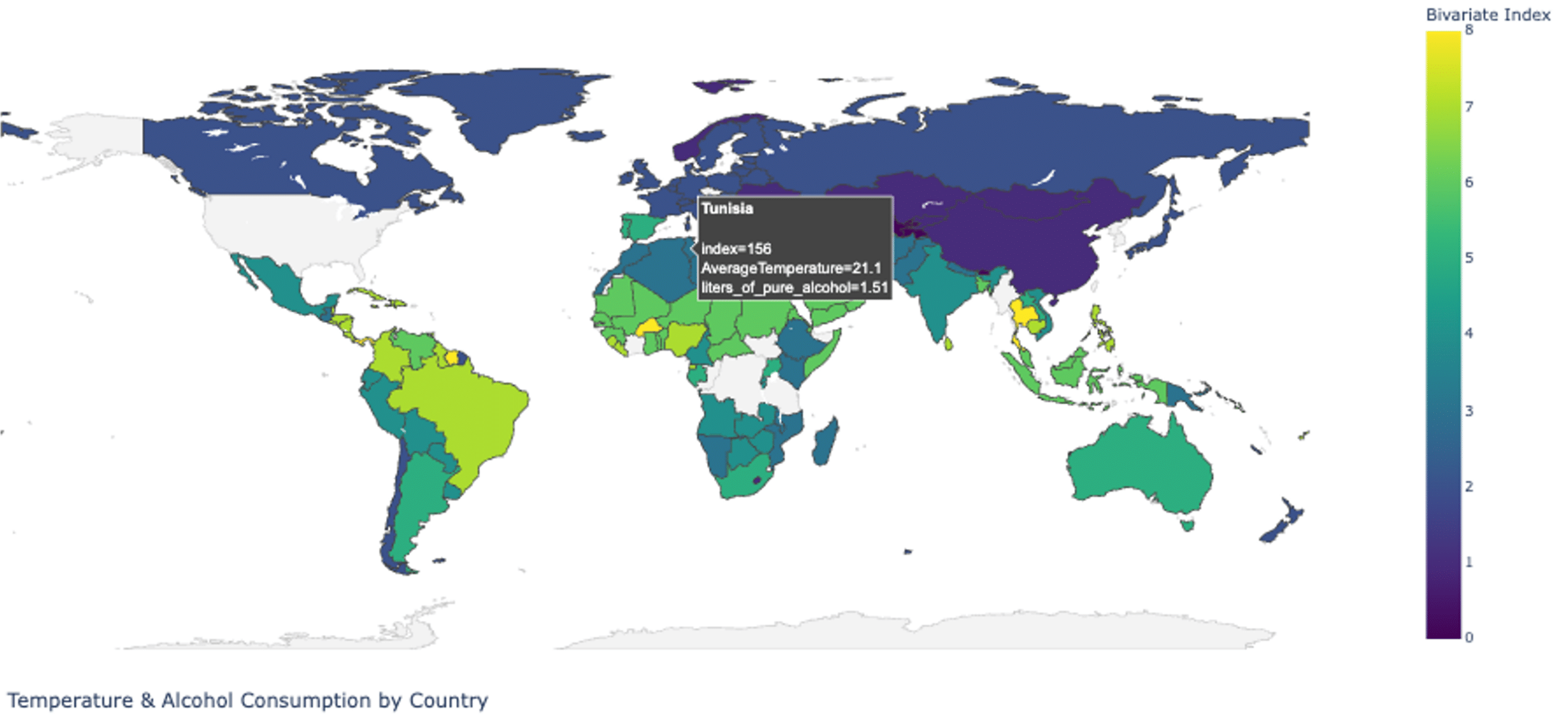
Deforestation, Land Cover, & Urbanization In Brasil – Dashboard

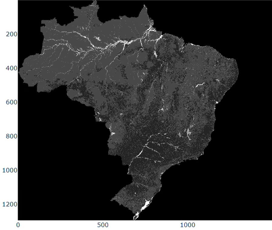
Deforestation Raster Map – 2024 The visualization depicts accumulated and annual deforestation patterns in Brazil from 1985 to 2024. The accumulated dataset shows a continuous rise in total deforested areas, reaching over 140 milllion hectares. Annual trends reveal strong fluctuations, with peaks in the late 1980’s and mid-2000’s, followed by decreases and renewed variability in … Read more

Urban Amenities Accessibility in Istanbul

How accessible is the city we live in? Beyond iconic landmarks and infrastructure, everyday life is shaped by small but essential places: schools, parks, shops, and services. Urban Amenities Accessibility in Istanbul is a computational design project that explores how these everyday amenities are distributed across Istanbul’s historical center and how easily they can be … Read more

Urban Healthcare

Cities are complex systems where accessibility to essential services—such as healthcare—can directly affect quality of life and emergency response outcomes. Traditional urban maps often show where services are located, but they rarely communicate how accessible these services are in real, everyday conditions. The This project explores how computational design tools can be used to analyze … Read more

Open to Sky

The aim of the project is to map the sky visibility in New York City as one walks from one public park to another with an added analysis layer of Heat Vulnerability Index (HVI)  to neighbourhoods. HVI is an index of the likelihood of someone from a neighbourhood to die due to excessive heat exposure, which … Read more

Flap-alona – butterflies, pollinators and Barcelona’s gardens

Pollinators, bees, butterflies, moths, bumblebees, quietly keep our ecosystems alive. They enable flowering plants to reproduce, sustain wild biodiversity, and support much of our food supply. Yet many of these species are in decline worldwide, threatened by habitat loss, chemical use, urban sprawl and climate change. In cities like Barcelona, where green spaces, gardens, parks … Read more

GG Worlds [v.2]

Introduction: From Words to Worlds Game design is one of the most creative fields in digital media today but for most developers, turning ideas into immersive worlds remains slow, expensive, and overwhelming. Especially for independent creators, level design, the art of shaping the physical and emotional journey of a player, is often the most demanding … Read more

Urban Vegetation Analysis Using Computer Vision and Deep Learning

(PaintDumpster/environmental_data_workshop at ndvi) – Link to GitHub This project aims to detect and classify different types of greenery in satellite imagery by utilizing color and edge detection techniques. The study area is located in Barcelona, Spain (41.396536, 2.194554). The stable version employs color and edge detection for image segmentation, while an alternative method integrates LiDAR … Read more

From Above the Acropolis: Satellite Analysis of Vegetation and Urban Heat in Athens

The project is situated in Athens, Greece, which overheats in the summer. We wanted to test a hypothesis: The overheating is the result of too much hardscaping (asphalt, concrete, brick) and not enough greenery. We wanted to compare the NDVI (a measure of greenery in a city) taken from Satellite images to Land Surface Temperature … Read more

Agrowealth : Does agriculture correlate to economy?

The goal of this project is to compare between the economic stability of an agriculture first city. Hamburg’s agricultural wealth is largely connected to its surrounding regions—particularly Schleswig-Holstein and Lower Saxony, which are among Germany’s leading food producers. Consequently, we focused on peripheral areas of the city that have recently transitioned into agricultural land, allowing … Read more

Flood Impact Mapping along the Turia River, València – Flood of 2024

When torrential rain dumped an entire year’s worth of water on Valencia in barely eight hours on 29 October 2024, the Turia spilled over its banks, submerging citrus groves, highways and whole neighbourhoods. More than 200 lives were lost, hundreds remained missing and Spain faced its worst flood disaster in recent history. Events like this … Read more

GG WORLDS [v.01]

GenAI for Game Environment Creation OverviewUrban environments in games play a crucial role in crafting immersive, dynamic worlds that captivate players and enhance storytelling. These settings not only shape the game’s atmosphere but also introduce strategic challenges and reflect cultural, social, and architectural identities, making virtual spaces feel authentic. However, creating high-quality, realistic game environments … Read more

Designing, communicating, and programming a user interface: SeisNAV

The first three exercises focused on designing and coding a landing page, visualizing geospatial data on Mapbox, and creating an interactive 3D experience with Three.js, each progressively building skills in design, data integration, and interactivity to address real-world challenges. ⠀ SeisNAV – User interfaces This project involved designing user interfaces for SeisNAV with a focus … Read more

SeisNAV

Abstract: Natural disasters, especially earthquakes, often leave roads blocked, buildings collapsed, and maps outdated, making navigation and response efforts highly challenging, That’s where we operate. Our project SeisNAV is an AI-powered platform that combines satellite imagery and computer vision to detect collapsed structures and road blockages, providing real-time mapping and navigation tools for disaster response … Read more