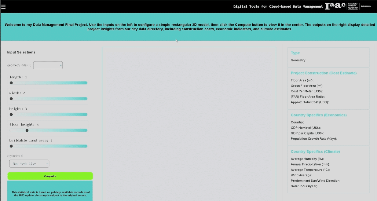
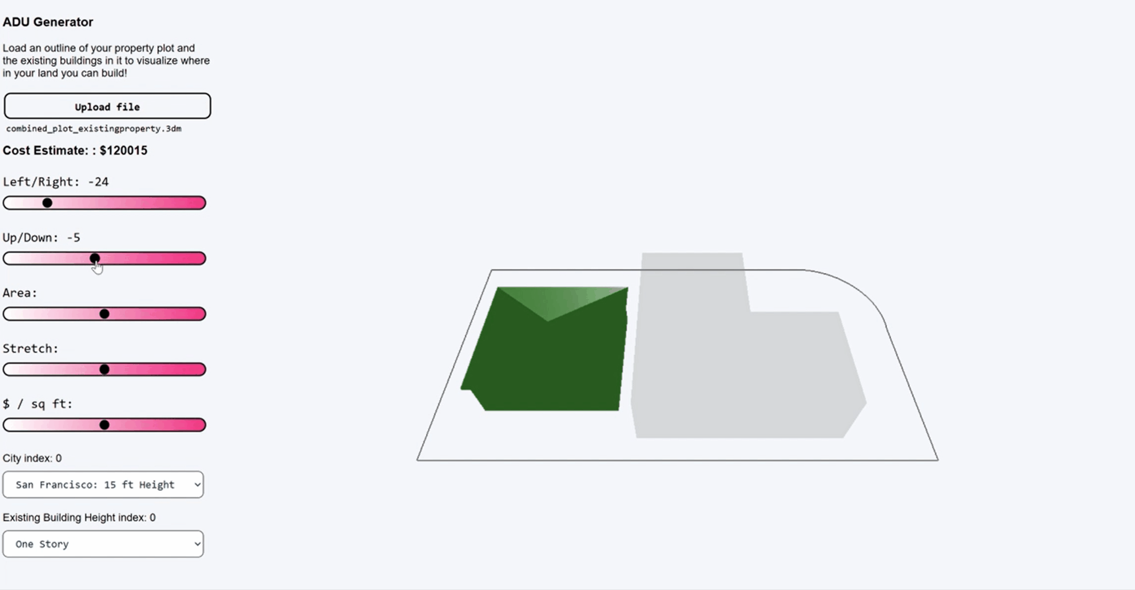
The MaCAD is a unique online programme training a new generation of architects, engineers and designers ready to develop skills into the latest softwares, computational tools, BIM technologies and AI towards innovation for the Architecture, Engineering and Construction (AEC) industry.

Urban Impact Analyzer

In the dynamic landscape of urbanization, migration towards cities is an undeniable trend. With this migration comes a myriad of challenges, notably the exponential rise in land costs and the often haphazard nature of urban development. As cities expand, there’s a pressing need for thoughtful and strategic construction that not only addresses the demands of … Read more

EVALUATE

Evaluate is an App that helps Investors and Planers to position their building on an uploaded Terrain, and visualize its Setbacks and Feasibility in terms of cost and total floor area. By automating this simple process, one can evaluate any building Plot simply by having its terrain, instantly and without bothering with checking specific Area … Read more

BIM and the Sustainable development of affordable communities for informal settlements in Egypt

Abstract Informal settlements across all of Egypt are characterized by complex socio-economic situations aggravated by the immense size of the population and its rapid growth. As a result of lack of building regulations, extreme poverty and continuous need for expansion, the rise of uncontrolled informal settlements remains a significant challenge for Egypt. Our research explores … Read more

Timber Lattice System – A Tale of Cairo’s Rooftops

This research aims to explore the application of timber lattice systems on roofs in Cairo, Egypt. Before delving into the project itself, a thorough review of relevant references was essential for a better understanding of the system. The building analyzed was the Sunny Hills Cake Shop, designed by Kengo Kuma and Associates. Characterized by a … Read more

Frihamns Navet Port HUB. Multilevel Timber-skeletons… at work 

This project, approached as a demonstrative project, was elaborated by Group 8, Anna Irene Del Monaco and Athanasios Vagias and worked on multilevel Timber structure.  We started investigating precedents on timber skeleton structure. Our initial interest fell on the Maggie’s center by Foster and partners for the masterful creation of a refined structural node in … Read more

Reversing Ecosystem Degradation

MaCAD 23/24 // ACESD Theory Existing State of Urban Design In order to understand how to strive for successful ecological design practices, designers must first understand the problems that currently exist in the process of urban design. The current state of design tends to create distinct enclosures between both natural ecosystems and humans, with the … Read more

GRAPH MACHINE LEARNING TOWARDS ADAPTIVE CITIES: A data-driven approach to sea level rise problematics

Abstract This thesis explores experimental approaches when addressing sea level rise challenges , the impacts of land loss due to sea rise and population growth. It delves into considerations associated with innovative approaches while emphasizing the integration of urban syntax and graph machine learning. Drawing upon case studies and open data, underscoring the importance of … Read more

Superblock BCN

A Multidimensional Study of the Superilla My research starts from observing human behaviour. Often when we face a change in our lives, especially when it wasn’t planned, we feel resistance and it takes time before we accept and embrace it.  As you probably know Barcelona in the last few years lived some changes in its … Read more

WEB GRAPH MACHINE LEARNING

Our project website can be accessed at bit.ly/graphml Introduction Our research focused on hosting a machine learning model on the web that accesses Rhino.Compute. It receives an input of a polyline drawn on a Leaflet.js map by a user to indicate the central corridor spine of a building and returns a graph of that building … Read more

FireFly

Harnessing the power of drone-based photogrammetry and artificial intelligence to create a low-cost urban wildfire diagnostic tool. In recent years, the global community has witnessed a significant upsurge in the frequency and intensity of wildfires. Driven by a combination of climate change, urban expansion, and land-use practices, these fires have not only devastated vast natural … Read more

Wildlife Corridors

Our project focuses on modeling and predicting habitat fragmentation avoidance mechanisms using graphs. We investigate wildlife corridors in Australia, leveraging graph-based approaches to create coherent passages and connect forest areas. By analyzing satellite images, road data, and other metrics, we construct and evaluate graph models that incorporate forest containment, node characteristics, and connectivity. Our goal … Read more

4sight

Insightful Predictions for Your City’s Future. The purpose of Foresight is to leverage the capabilities of machine learning to anticipate the potential effects of novel urban infrastructure on the city’s fabric and the value of city blocks. Foresight aims to serve as a preliminary design tool, with the ability to swiftly process vast amounts of … Read more

Routable

An Urban AI graft project based in Barcelona. In 2022 across both England and Wales the proportion of people that have some form of disability was a staggering 17.8% or nearly 10.4 million people. Our project is focused on urban mobility and aims to create accessibility for current routing applications have limited use for people … Read more

fumbrella

Harvesting water and sunlight Imagine if we could solve both a water and energy crisis using urban installations. Take a funnel to collect water and merge this with an umbrella. What do you get? A fumbrella of course! In this module we created a custom web app using JavaScript and Vue components. This web application … Read more

Mars Medical Center

Introduction For the BIMSC studio project, the class designed a human colony initially capable of accommodating 50 inhabitants, with the potential to expand to 300 inhabitants. Working together, the class settled on the Jezero Crater as the site for the colony and developed a masterplan consisting of thirteen distinct zones. Each group selected one zone … Read more

death != random

Github Link https://github.com/jamesmcbennettIAAC Week 1: Weaving in Hops Our first assignment was to familiarize ourselves with how to prepare Grasshopper files for Hops. I created a weaving definition that could change between Tabby, Twill, and Satin weaving patterns with parameters to increase or decrease the density of the model, the thickness of the thread, the … Read more

Leveraging the Power of Integration: BIM and GIS for Improved Urban Planning

Brief Building Information Modeling (BIM) and Geographic Information System (GIS) have different focuses and interpret 3D models differently. BIM manages detailed building components, project information, cost, and schedule from an architectural and construction point of view, while GIS manages the geographical information of buildings and their components from geographical viewpoints, which helps to manage the … Read more