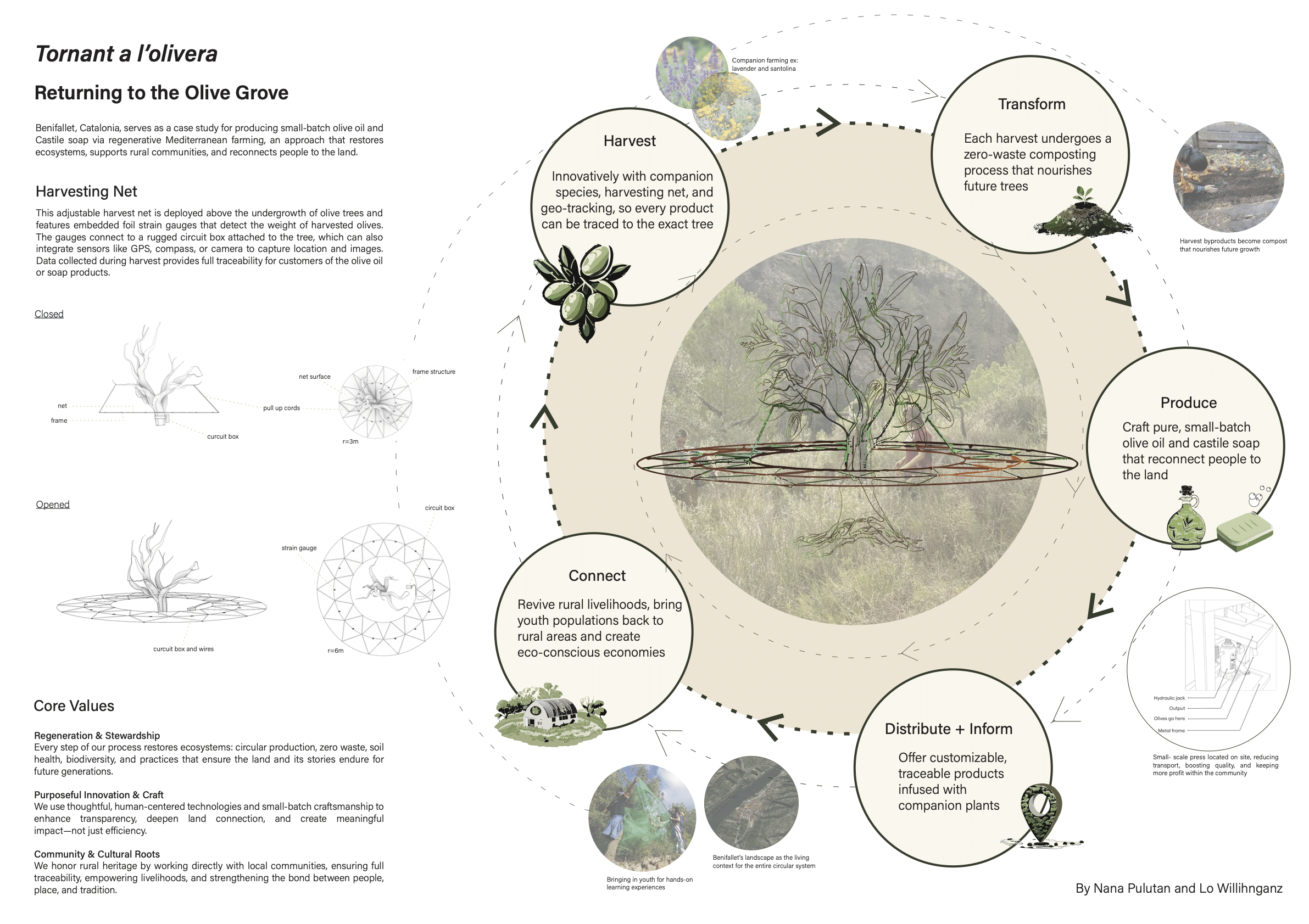
CONVEA
USING CORK AS A DELINEATOR OF INTERNAL CLIMATIC PROGRAMS a. initial machine phenomena studies b. first iteration of phenomena recreated c. second iteration of phenomena model on column site d. photographs of second iteration
Introduction The Self sufficient building studio students were tasked to use an old yet functional electronic equipment , understand its function and then integrate it into a new prototype body, repurposing its function which could later help sustain an architectural space. I, a one man group, decided to work with water in gaseous state- steam. … Read more
A space for human driven by human On a planetary scale, these dynamics of solar heating, infrared cooling, and moisture transport create global patterns in climate. This study explores how temperature and humidity generated through human exertion at different activity levels can be passively regulated to create adaptive microclimates tailored to occupant circadian rhythms and … Read more
Analog End Effector Explorations Mechanical End Effector Explorations Final Robotic Jig Design | Facade Iterations
Workflow for Detection (Transformation to the Real World) Test for getting the points in real world Workflow for Detection (Getting points into the Trajectory) Test for getting the points in real world Workflow for Detection (Processing on Point Cloud) Test for getting the points in real world Machina Connection for ABB_6700 (Simulation)
AIM The goal is to teleoperate both the Husky robot and the UR10e arm, enabling them to avoid obstacles on the floor and push those that are unavoidable. To achieve this, we designed a system that allows the user to control both robots using any available camera, incorporating hand tracking for intuitive command execution. SYSTEM … Read more
El Poblenou is a neighborhood in Barcelona which is experiencing several degrees of transformation leading to urban niches unconsidered. Open City Poblenou envisions public spaces that respond to urban flux, creating environments that encourage interaction and a sense of belonging through co-designed, adaptive interventions by leveraging data-driven strategies and participatory design. INDEX 00_IntroductionExplanation of Poblenou’s … Read more
Sobre latencias y oportunidades en el abordaje de la vacancia en la Ciudad de Mendoza, Argentina RESUMEN La problemática de los pasivos urbanos, definidos como terrenos subutilizados o infraestructuras obsoletas dentro del tejido urbano, constituye un fenómeno global con implicaciones territoriales y socioeconómicas a escala local. La expansión urbana no planificada, caracterizada por patrones de … Read more
Define Base Surface Define a planar surface with boundary conditions Generate Mesh Discretize the surface using a triangulated or hexagonal mesh Identify Anchor Points Distribute anchor points randomly manner across the mesh Introduce forces or constraints at anchor points to manipulate the mesh. Extrude elements from the anchor points to create structural support Use parametric … Read more
What defines a mixed-use space? How do we visually recognise the coexistence of residential, commercial, and public spaces in a city? Can AI perceive these complex urban conditions as we do? This workshop explores how Visual Language Models (VLMs) interact with urban imagery, using street view images to assess land-use patterns. By comparing Barcelona and … Read more
Introduction In the face of increasing climate-related disasters, accurate and efficient scanning methods are essential for assessing structural integrity. Our team developed a robotic scanning solution that utilizes LiDAR-based Husky A200 and drone photogrammetry to detect roof anomalies, such as holes and structural weaknesses.This study explores different scanning methodologies and evaluates their effectiveness in detecting … Read more
Mobile Robotic Scanning & Discrete Element Analysis This workshop served as an introduction to mobile robotics for scanning. We explored various types of mobile robots and different kinds of sensors, focusing on how they integrate with one another to enable diverse scanning approaches. Based on these investigations, we designed a specific scanning methodology suited to … Read more
Github : https://github.com/j-albo/robotic-3d-space-analysis INTRODUCTION Scanning irregular terrains with today’s scanning technology is crucial for obtaining precise environmental models, optimizing planning and execution in architectural projects. Its high-resolution capture capability allows for mapping complex surfaces and detecting floor level variations imperceptible to the human eye, improving efficiency and reducing errors in design and construction. WHY USING A MOBILE … Read more
Github : https://github.com/j-albo/scanning-wood-waste INTRODUCTION Currently, only 15% of wood waste is recycled globally, while up to 60% of felled trees remain unused. Many irregular pieces that do not meet industrial standards are discarded without leveraging their structural and aesthetic potential. Our goal is to rethink these waste materials through scanning, analysis, and digital transformation, converting them into … Read more
“The Amazon rainforest, often called the ‘lungs of the Earth,’ is rapidly disappearing. But this isn’t just an environmental crisis—it’s a geopolitical and economic issue. In the heart of this transformation lies [Mato Grosso], Brazil’s largest soy-producing state. Its key location fuels both economic growth and ecological destruction, leading to tensions over land use, trade … Read more