
By Team – 41 Commons
C40 Competition Brief
“The City of Chicago and Chicago Housing Authority area seeking innovative design ideas that will help envision solutions for environmental concerns and prioritise a sustainable, inclusive urban living environment”
“The key climate and environmental justice concerns at this site are:
Air Quality
Flooding
Cohesive Community Green Spaces
Heat Vulnerability
Site Context :
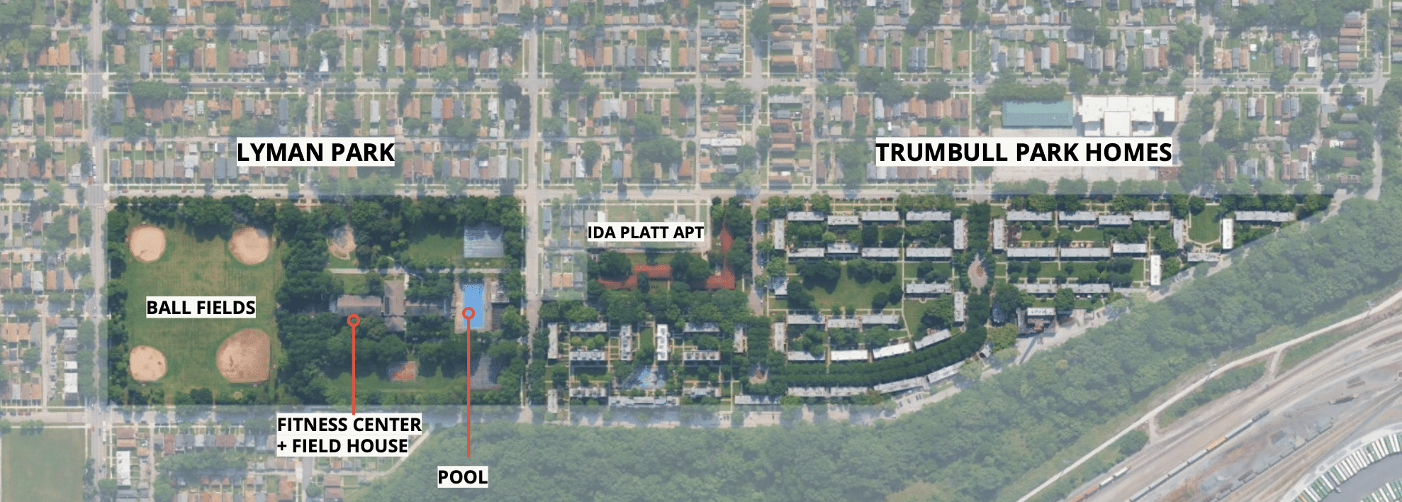
Site community:
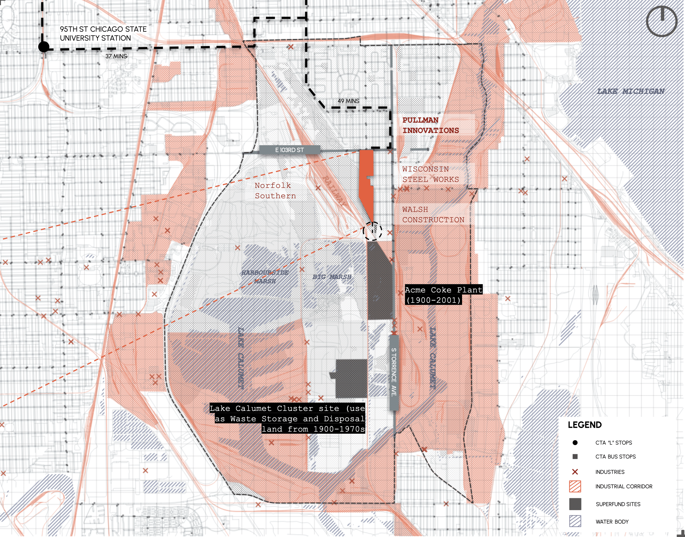
The site is situated at the end of the residential area of South Deering which surrounded by major freight train lines, highways, superfund sites, industrial and manufacturing zones, rivers/marshes,and lakes.
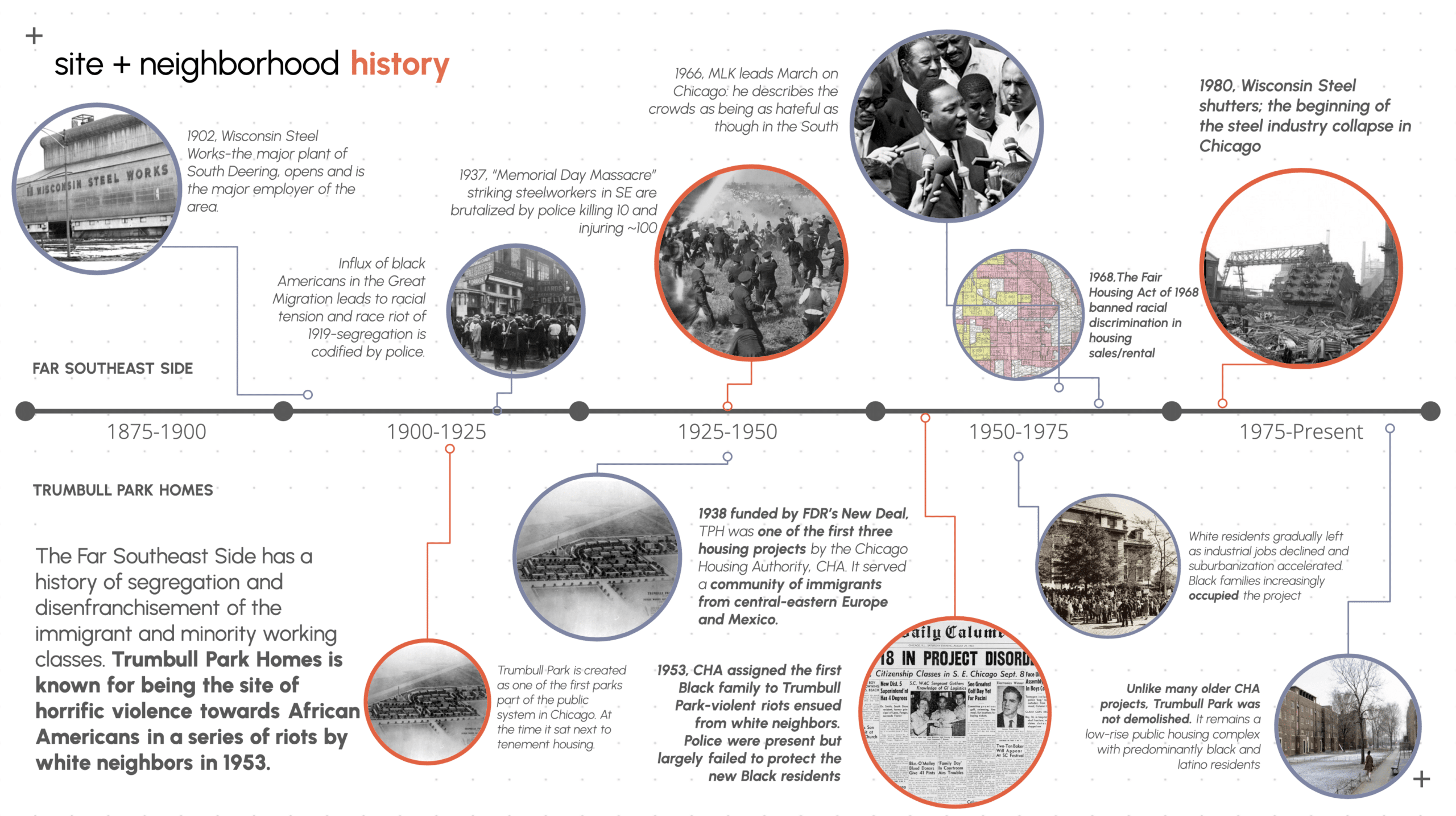
Site Neighbourhood History :
The environmental and social conditions at Trumbull Park Homes today are not accidental. They are the accumulated outcome of a century of industrial activity, racial violence, disinvestment, and policy failure. Understanding the present requires reading the timeline.
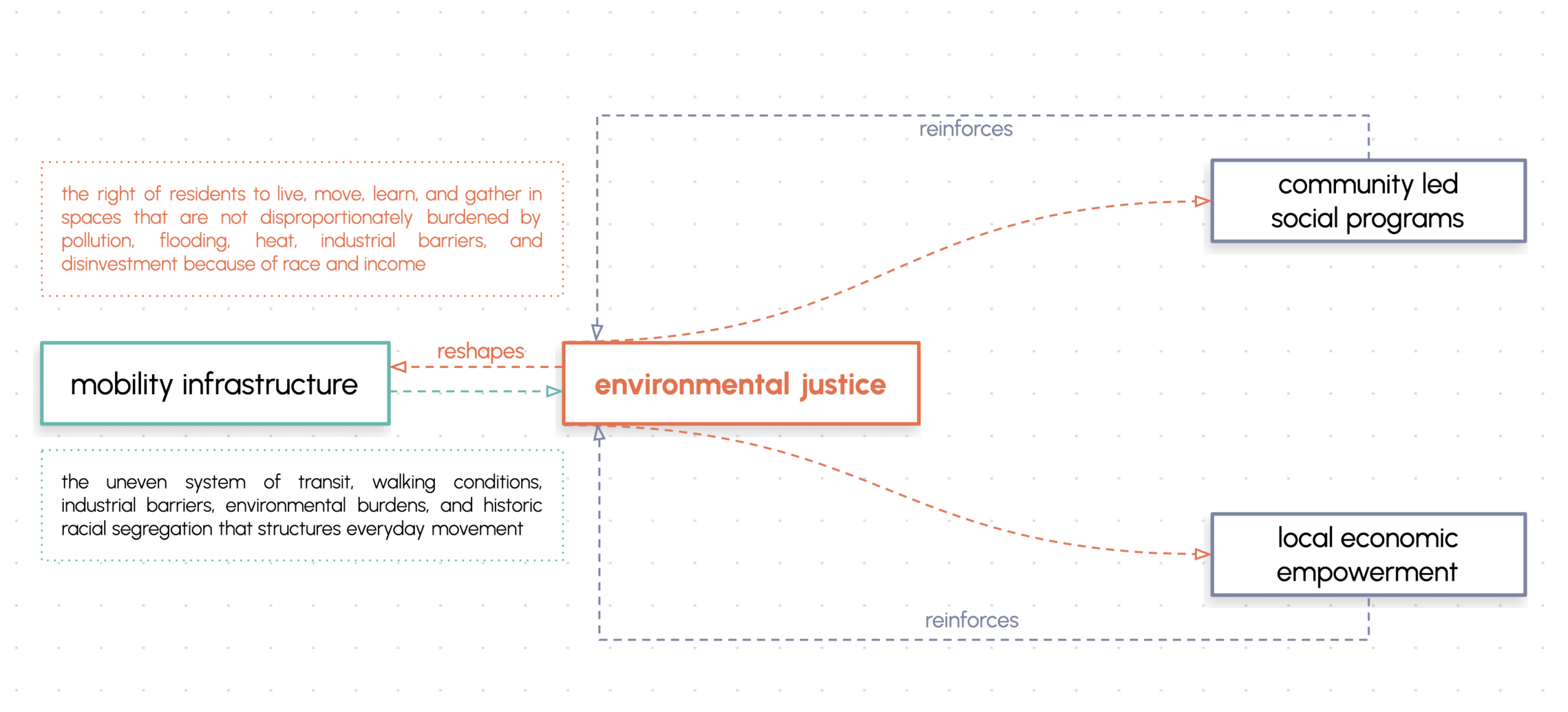
Urban Issue
A community burdened by pollution, flooding, heat, industrial barriers, and disinvestment because of race and income.
Environmental justice EPA+
Environmental justice EPA+
“…Environmental justice strives to ensure the equitable and just distribution of resources and benefits in a manner that prioritises communities experiencing the greatest inequities, disproportionate impacts, and unmet needs…It also works to prevent environmental harms, address discriminatory policies, and eliminate systemic barriers to healthy, sustainable communities for all people.”
“Lee, C. (2021). Evaluating EPA’s Definition of Environmental Justice. Environmental Justice, SAGE Publications
In the United States,
Environmental injustices are rooted in structural and historical discrimination based on:
Race Class
Culture
Origin
Education
Ability
Age
Gender
Sexuality
In TPH / South Deering
Historically→ lower-income working class, immigrants
Demographic change occurred and environmental harms continued
Currently → lower-income, working class, people of color
Example: Pullman Innovations (near TPH) accumulated over a dozen air pollution violations. It settled for $12,000 and admitted no wrongdoing. Residents describe air that ‘burns their eyes and nose.’ (Chicago Sun-Times, 2023)
South Deering + Trumbull Park have been officially designated Environmental Justice communities
(Chicago CIA Report 2023)
Population Context
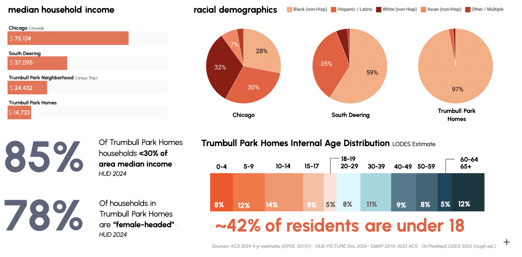
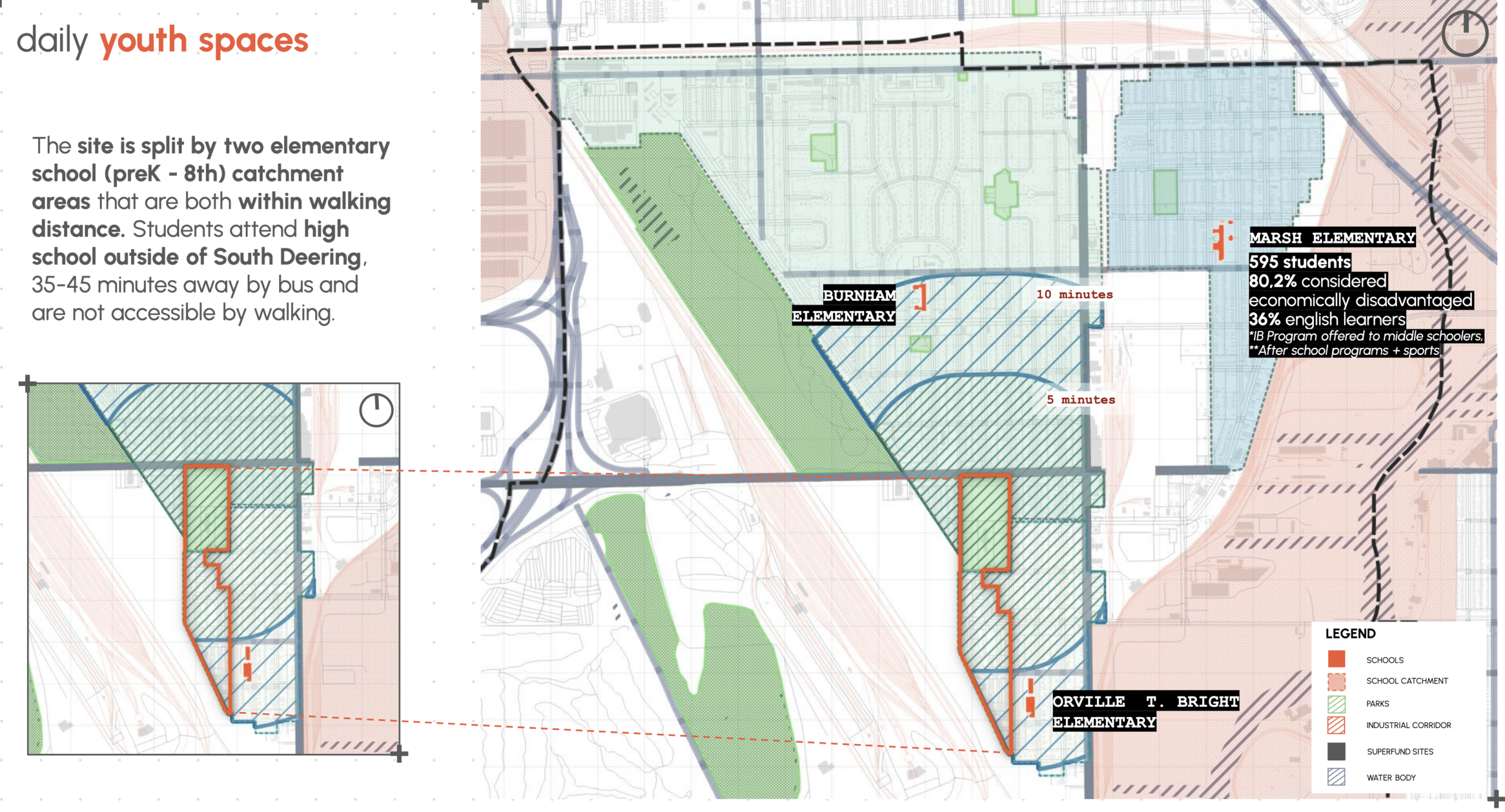
Where Are the Tweens Going?
The demographic concentration of children and tweens at TPH — 41% of residents under 18 creates a spatial demand for age-appropriate informal space that the site currently cannot meet. Our social infrastructure analysis mapped the gap between that demand and what is actually available.
The Two Schools
Orville T. Bright (PreK–8)
216 students · 67.1% economically disadvantaged · 30% ELL · NO after-school, safe passage
Burnham Elementary
403 students · 96.3% economically disadvantaged · 4.2% ELL · Has after-school, safe passage routes
“Each weekday at 7:30 am, tweens from Trumbull Park Homes go to school crossing stinking and flooded streets. Around 2:45 pm, they leave school into the same landscape they inhabit daily, with few informal, age- appropriate spaces to spend their independent after-school time.”
Lead user: Tweens
We have chosen tweens — roughly ages 9–12 — as our lead user group. This is not an arbitrary choice. Tweens are old enough to navigate the neighbourhood independently but structurally unable to access transit to reach resources beyond it. They are the primary users of informal outdoor space.They are forming their identities, their sense of place, their relationship to public life. And they are the age group that is most present on the site, most exposed to its conditions, and most absent from the decision-making processes about it. Designing for tweens does not mean designing only for tweens. It means designing for the most demanding, most spatially dependent, most underserved user — which tends to produce infrastructure that works for everyone.
Research Question?
How can tween – centred mobility infrastructure at Trumbull Park Homes be designed for environmental justice while serving as a platform for climate-resilient regeneration, community-led programming, and local economic empowerment?
Objective : To enable the community to continuously evolve in response to its needs
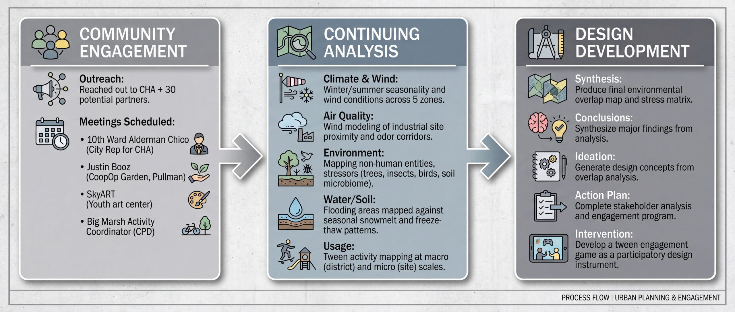
Methodology:
Research Design: Four Parallel Analytical Tracks
Our methodology operates across four simultaneous analytical tracks — ecological systems, hydrological systems, mobility networks, and social infrastructure — all viewed through the lens of the tween lead user and directed by the research question. Each track produces findings that feed into a layered design decision map.
Stage 1: Background Research
— C40 Brief and Intro Webinar Analysis — identifying key issues and client priorities
(Environmental Justice priority).
— Archival media and stories — Chicago Tribune archives, historical photographs, oral history accounts.
— Historical literature review — segregation histories, CHA policy history, Memorial Day
Massacre context.
— Scientific environmental research review — peer-reviewed literature on urban heat islands, bioretention, compound stress.
Stage 2: Context Synthesis → Research Question
— Periodical review and social media analysis — community narratives, current resident
voices.
— Demographic analysis — HUD PICTURE, ACS 5-year estimates, CMAP data.
— Asset mapping — recreation infrastructure, school provision, transit access.
— Lead User Framework: Tweens — demographic concentration, spatial adjacency, design capacity.
Stage 3: RQ-Specific Analysis
Ecological systems
— Seasonality research — Chicago climate data, HVAC demand patterns.
— Tree species and canopy coverage analysis — connected-component labelling from aerial photogrammetry.
— Heat island mapping — LST via Grasshopper and satellite data.
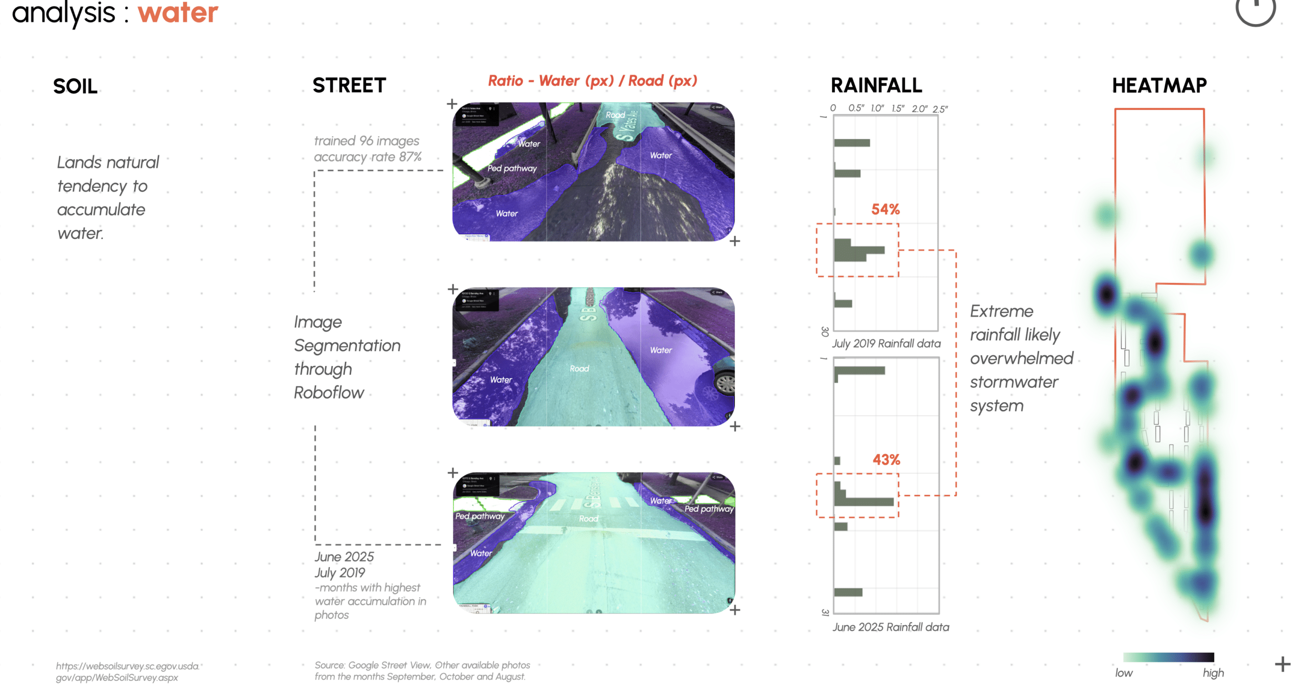
Hydrological systems— Soil scientific literature review — USDA Web Soil Survey.
— Soil typology mapping — Fill–Clay Loam (42%), Wasted (15%), Gilford (5%).
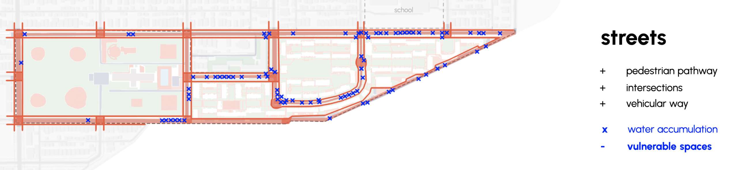
— Flood stress mapping — heat map of water accumulation overlaid on CEVI.
Mobility networks
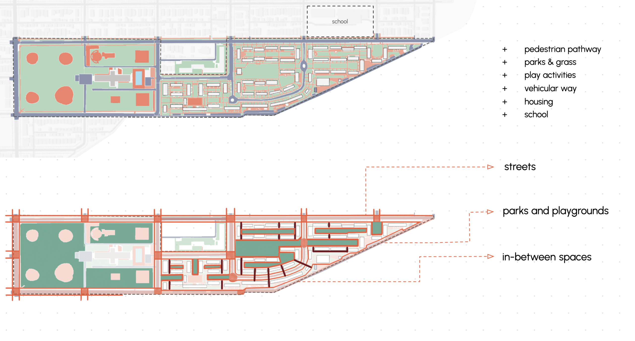
— Tween-focused mobility infrastructure mapping — pedestrian pathways, crossways, streets, parks, rec centre, pool.
— Literature review on mobility justice in physical and social context.
— Tween independence literature review — spatial behaviour, independence thresholds.
Social infrastructure
— Tween social programme data scraping and geocoding — Spring 2026 activity provision.
— Tween asset mapping
— schools, re centre, park facilities.
— Tween engagement game development — participatory design tool.
Stage 4: Design Iteration + Final Deliverable
— Informed regenerative design interventions — drawing on all four tracks.
— Design iteration through subjective crits and objective simulations.
— Continuous stakeholder feedback — CHA, 10th Ward, community leadership, residents.
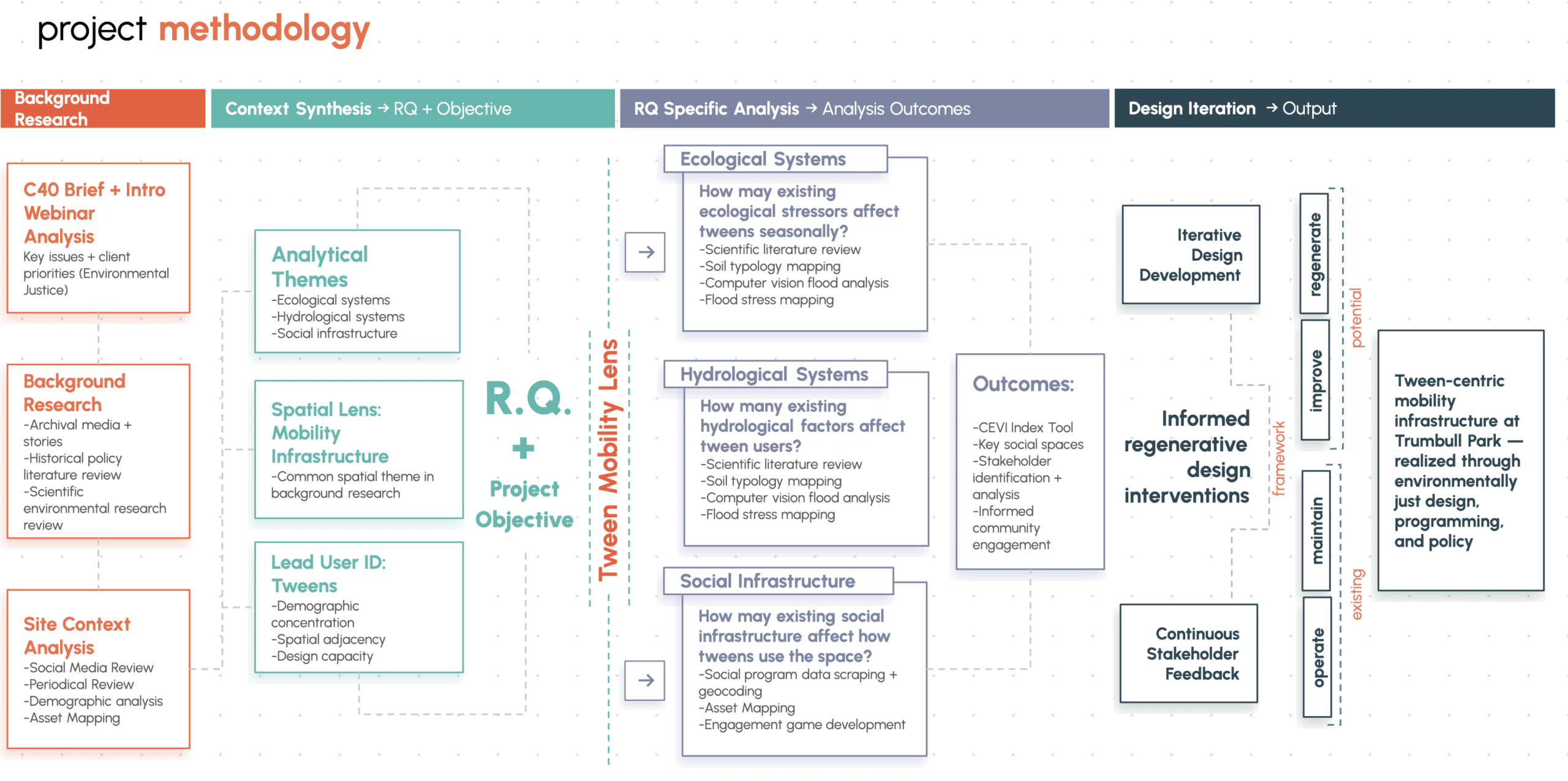
Project Statement:
Trumbull Park Homes — demographically young and spatially adjacent to two elementary schools — is uniquely positioned to reimagine public space through tweens as lead users.Our project uses literature review, remote-sensing environmental, and secondary social data to address environmental injustice by proposing tween – centred, regenerative nature-based living systems that restore and promote mobility to reduce the environment stressors and to empower the local community.
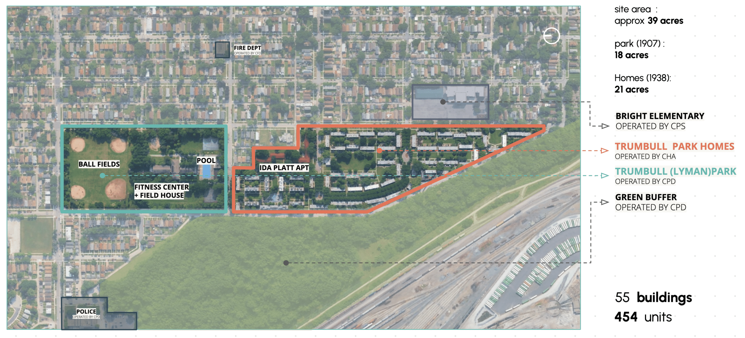
Site Introduction:
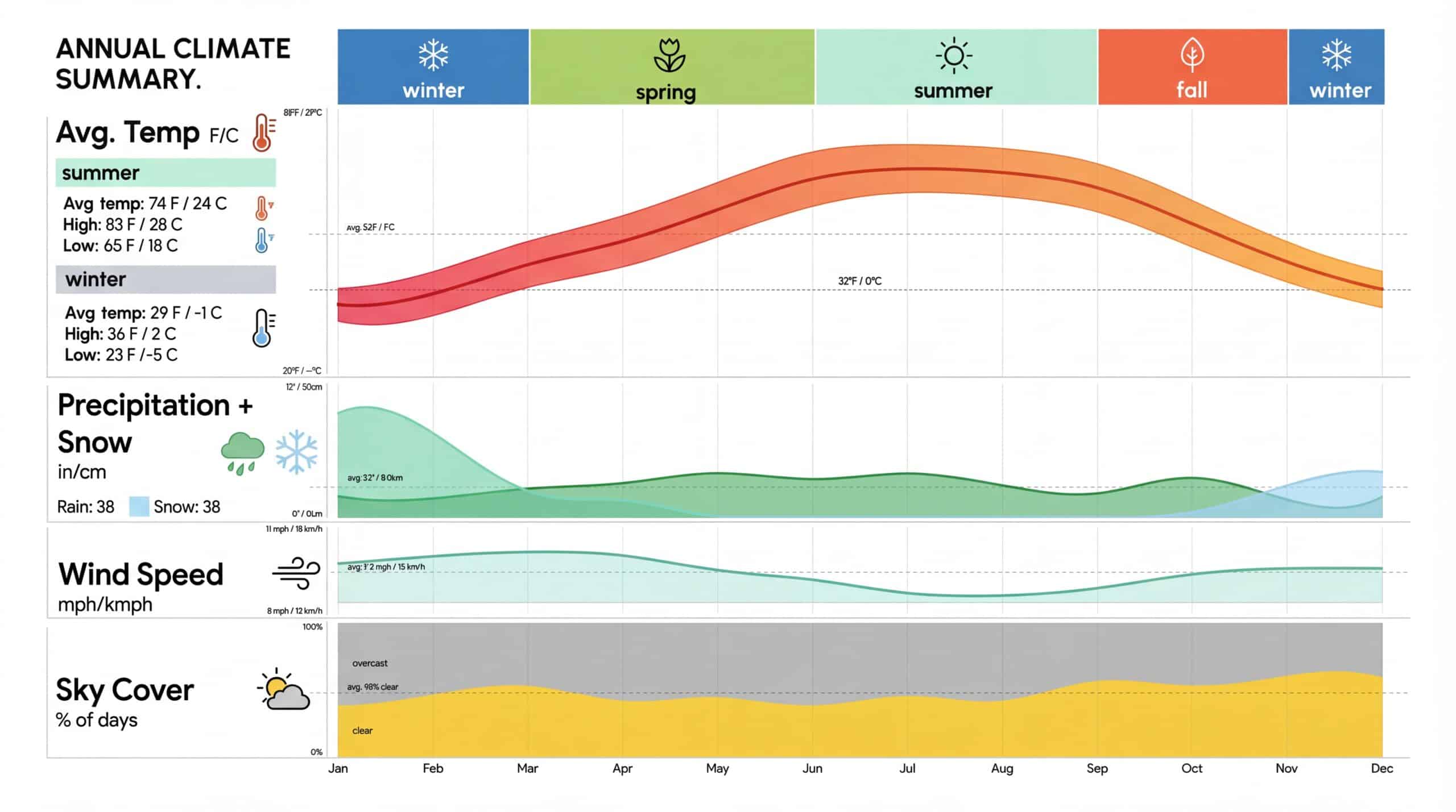
Chicago’s Seasonality:
The green space that isn’t : paradox of open space:
Trumbull Park’s ST range from 18.5 to 25 deg.C in summer, with the hottest zones concentrated over exposed dirt, soil and concrete. Tree canopy exists but is fragmented-clustered at edges, leaving the park’s interior largely unshaded. Direct and indirect cooling zones are isolates pockets, not a connected thermal network.
22.4 % of Trumbull Park —nearly 1 in 4 sq.m of open ground – has no direct tree shade. On a summer day above 32 deg.C, that space is thermally inaccessible to children
Flooding Analysis
After-school activity gaps
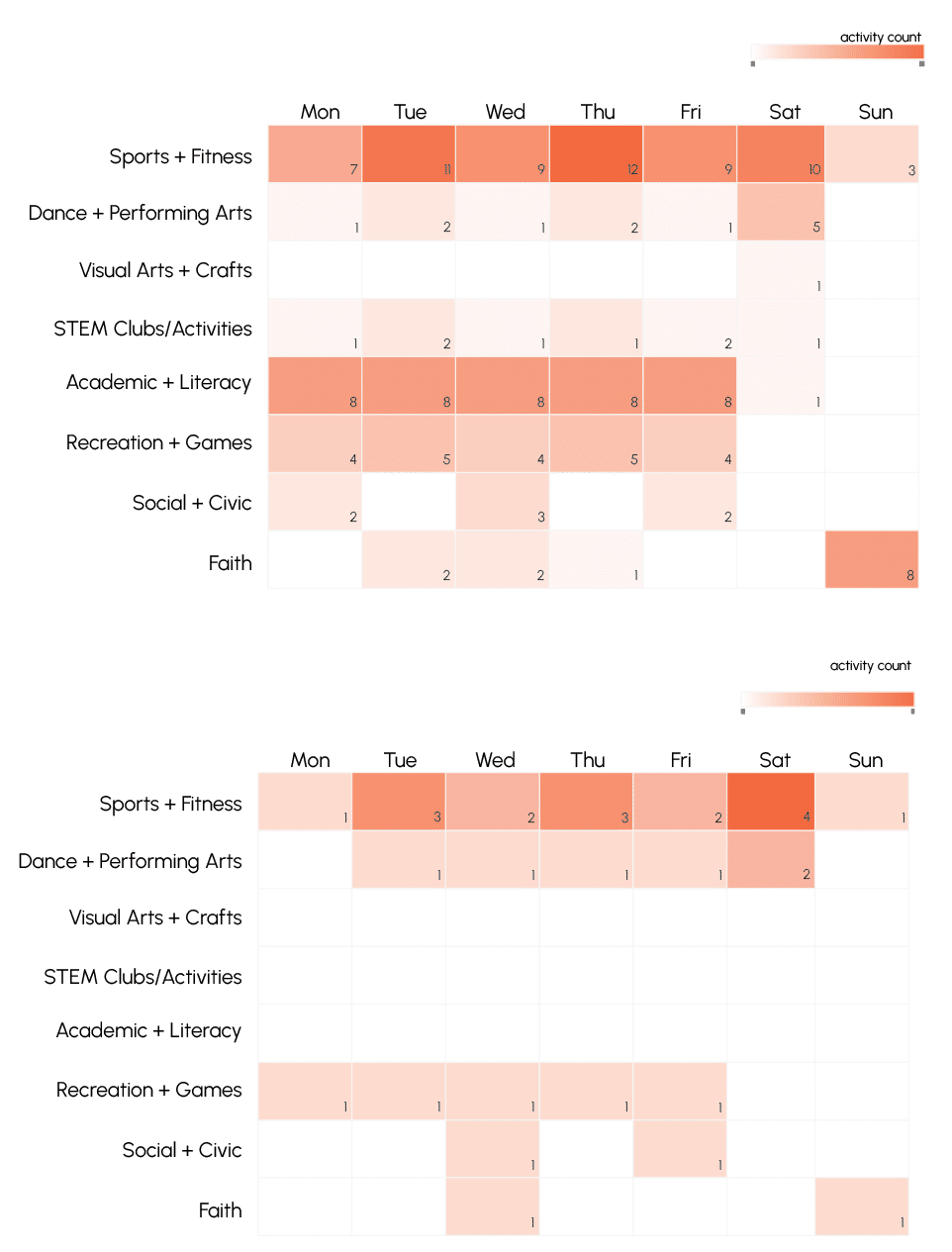
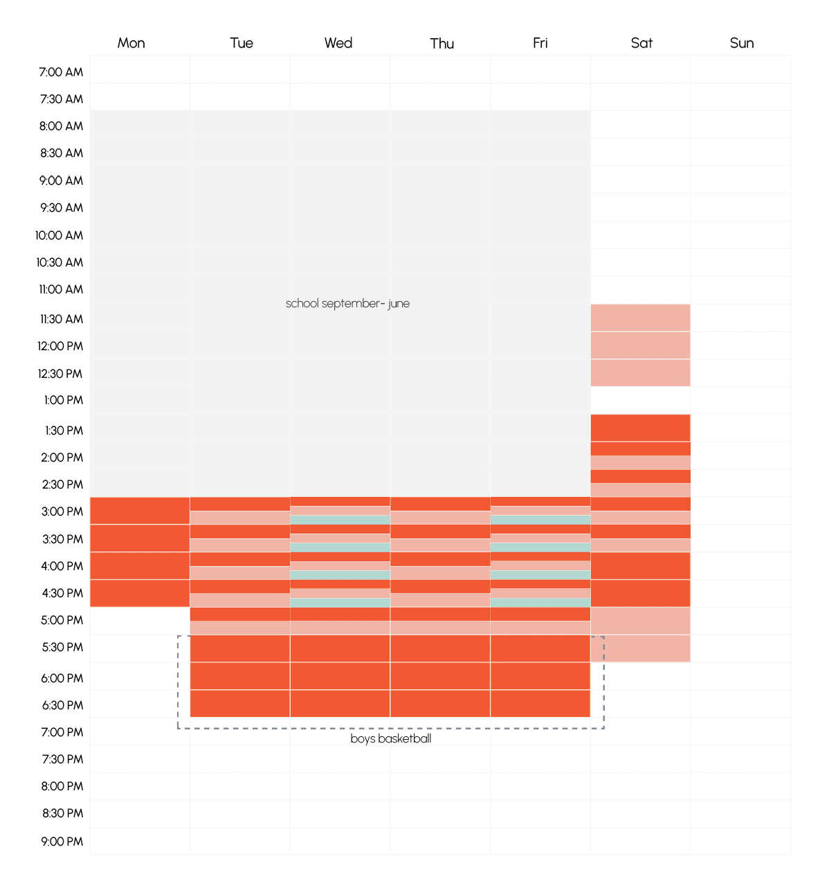
Only 20% of recurring activities in 2026 are within reasonable walking distance of TPH
Story Line
“Each weekday at 7:30 am, tweens from Trumbull Hall Park Homes go to school crossing stinking and flooded streets. Around 2:45 pm, they leave school into the same landscape they inhabit daily, with few informal, age-appropriate spaces to spend their independent time.after School Time.“
Which spaces do tweens move through?
And where do they face these environmental ?
Detailed Site Analysis
Vulnerable Spaces (Water accumulation)
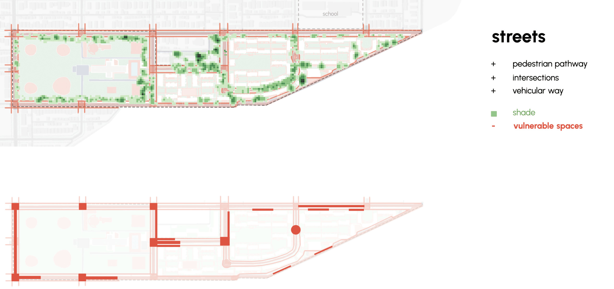
Recreational and Play Areas
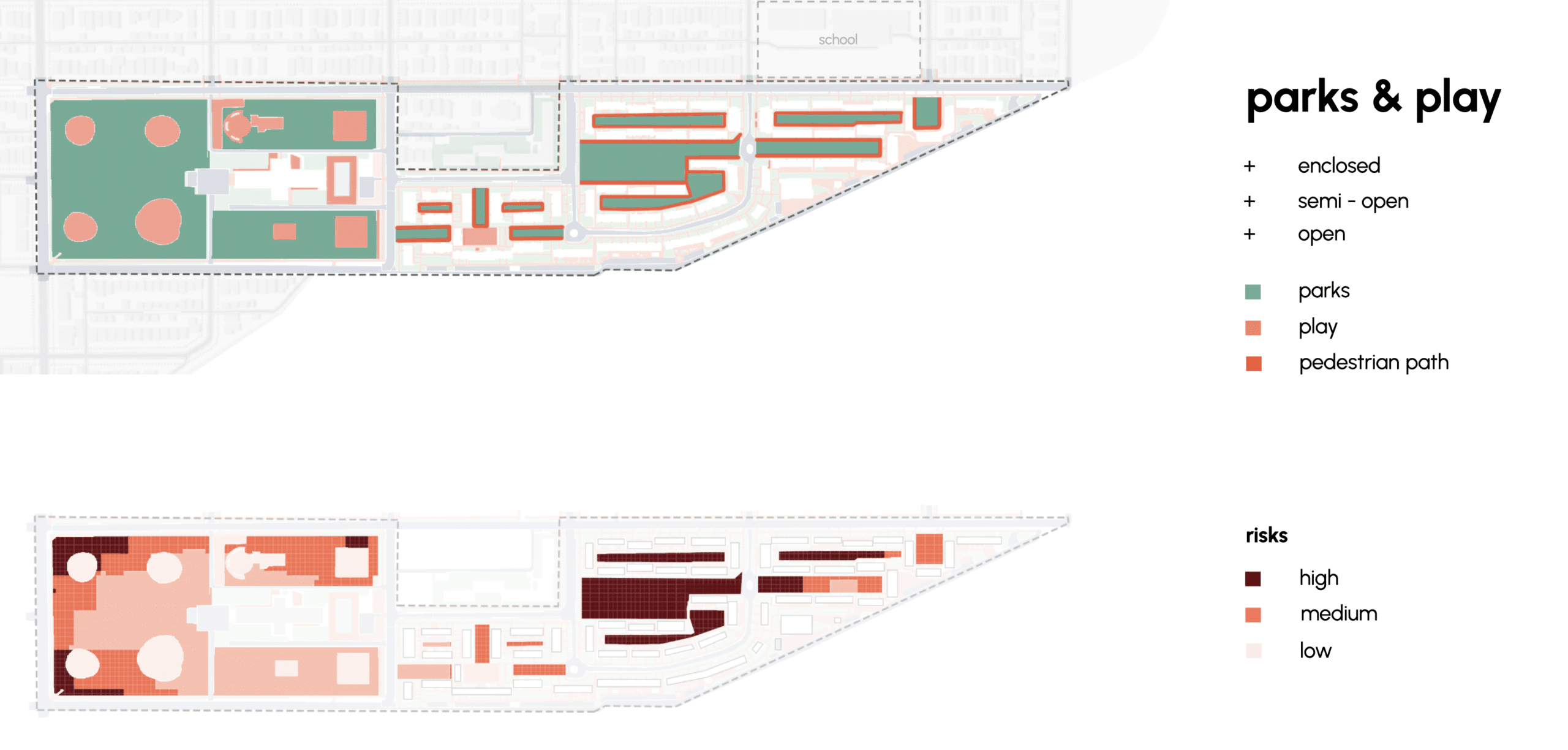
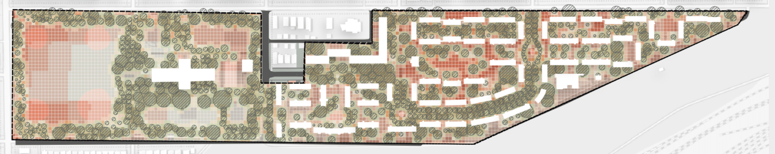
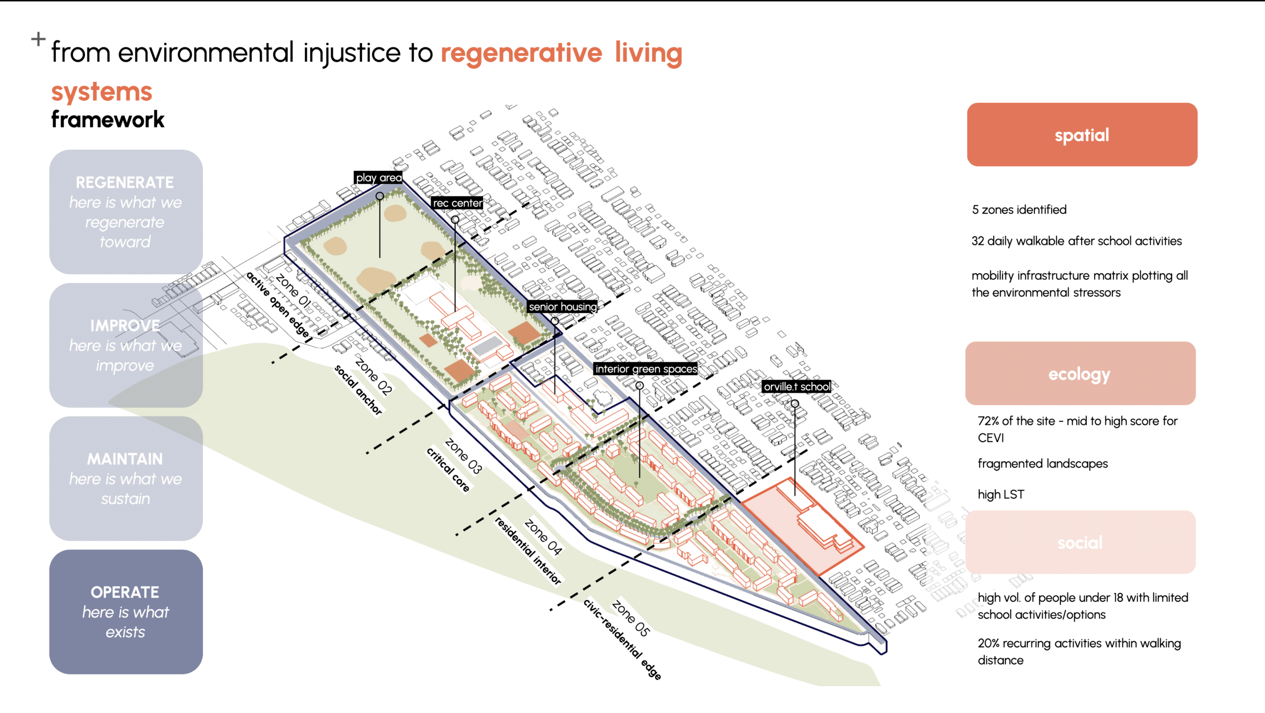
Design Strategy – design intervention area Identification – CEVI
The CEVI maps compound environmental stress across every 5×5 metre cell of the site, combining heat, NO2, flooding, albedo, canopy cover and uncooled zones into a single core. 67% falls under the medium to high compound vulnerability, meaning stress here isn’t isolated to a few problem spots, it’s the condition of the site itself.


When we overlay tween activity patterns against the CEVI, a gap emerges. The areas where kids actually spend time — both programmed and non-programmed — tend to avoid the highest vulnerability zones, leaving large stretches of high compound stress with no activation, no shade, no reason to stop. These are precisely the spaces the design needs to address.
Design Ideation & Strategies
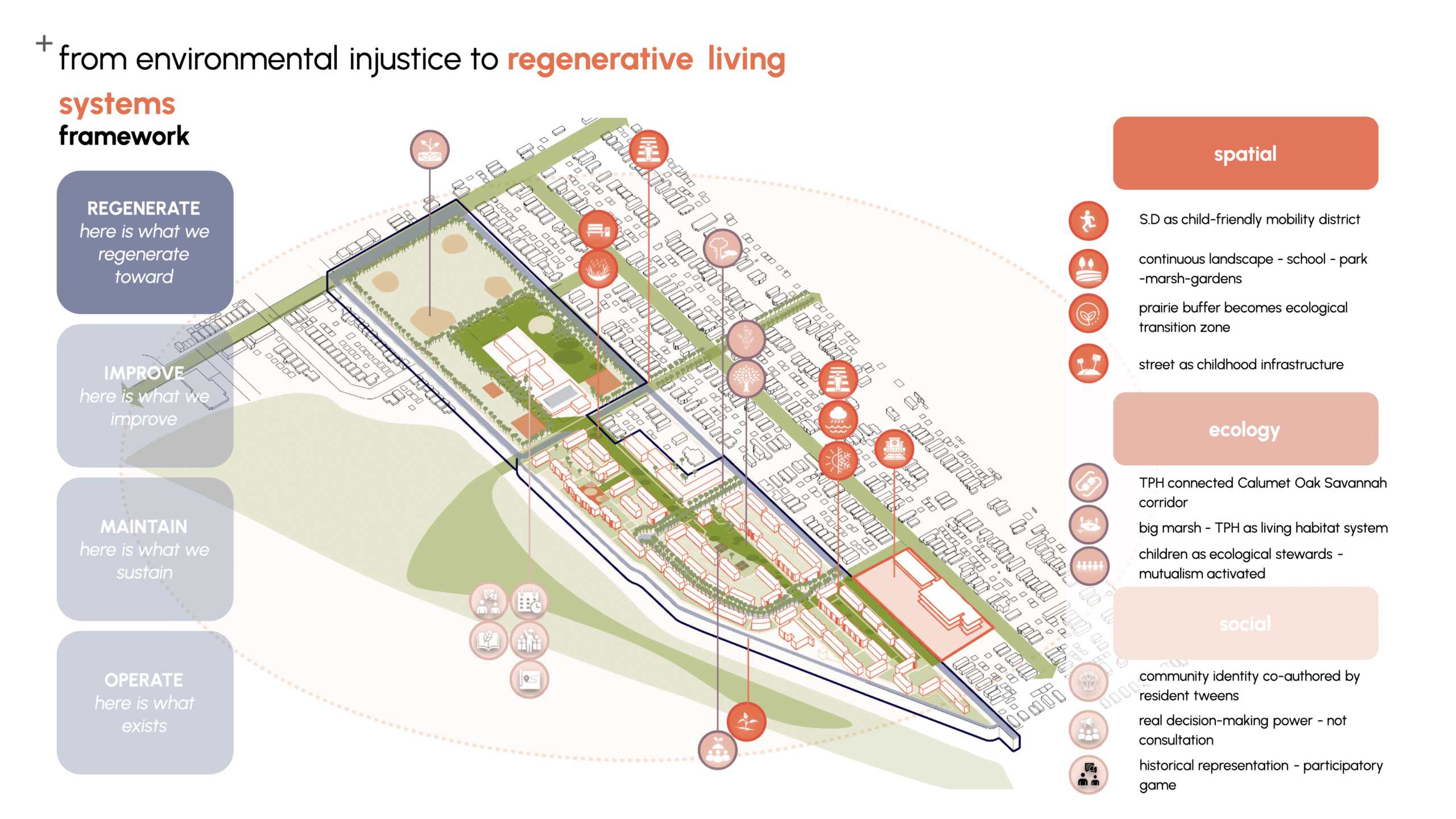
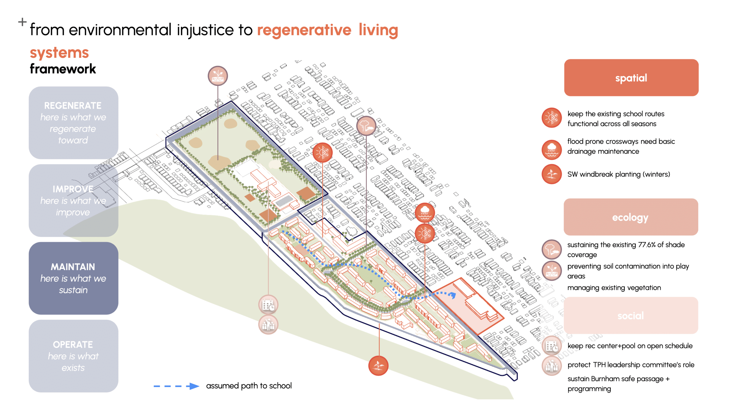
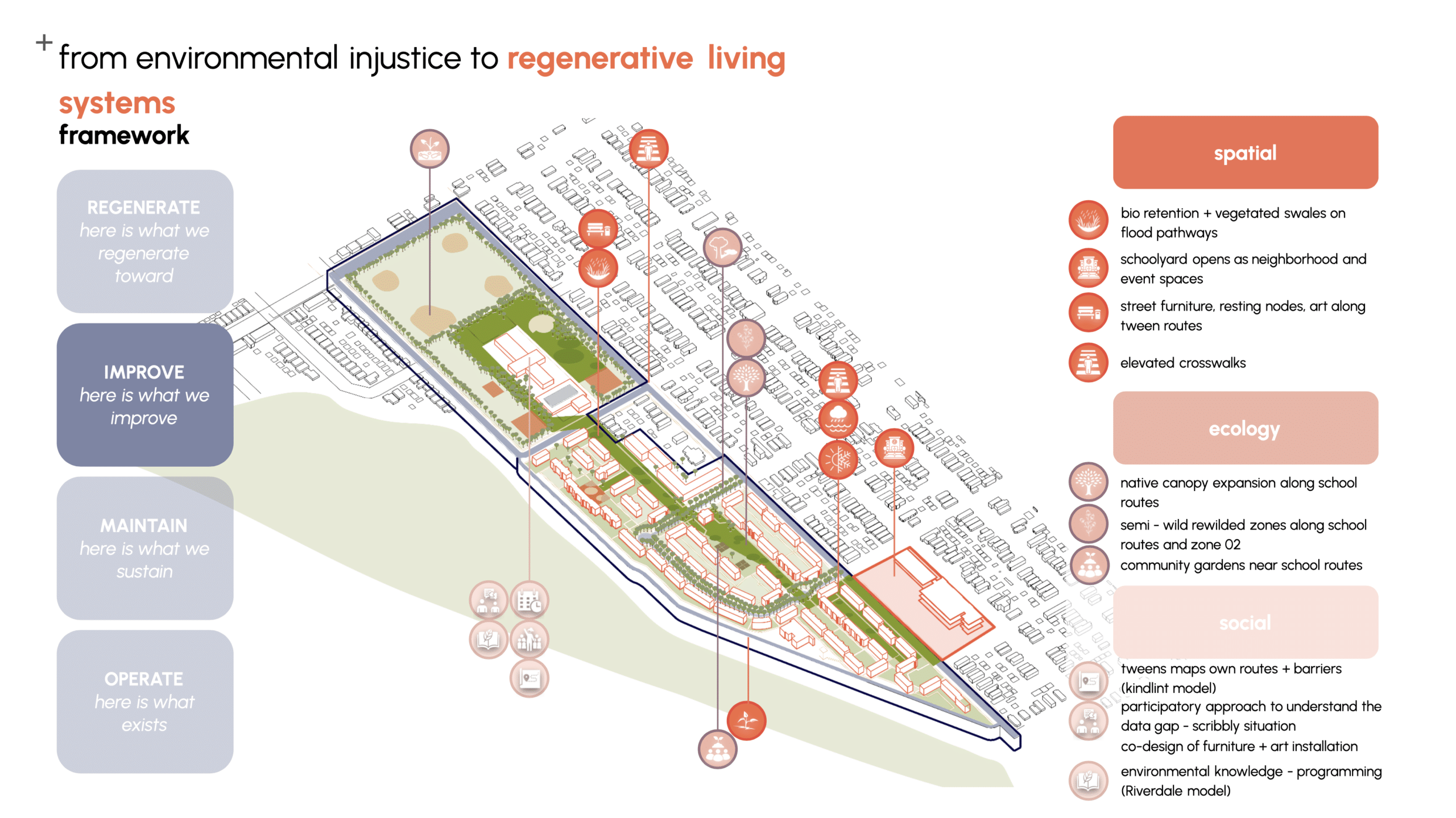
Regenerative nature based living systems?
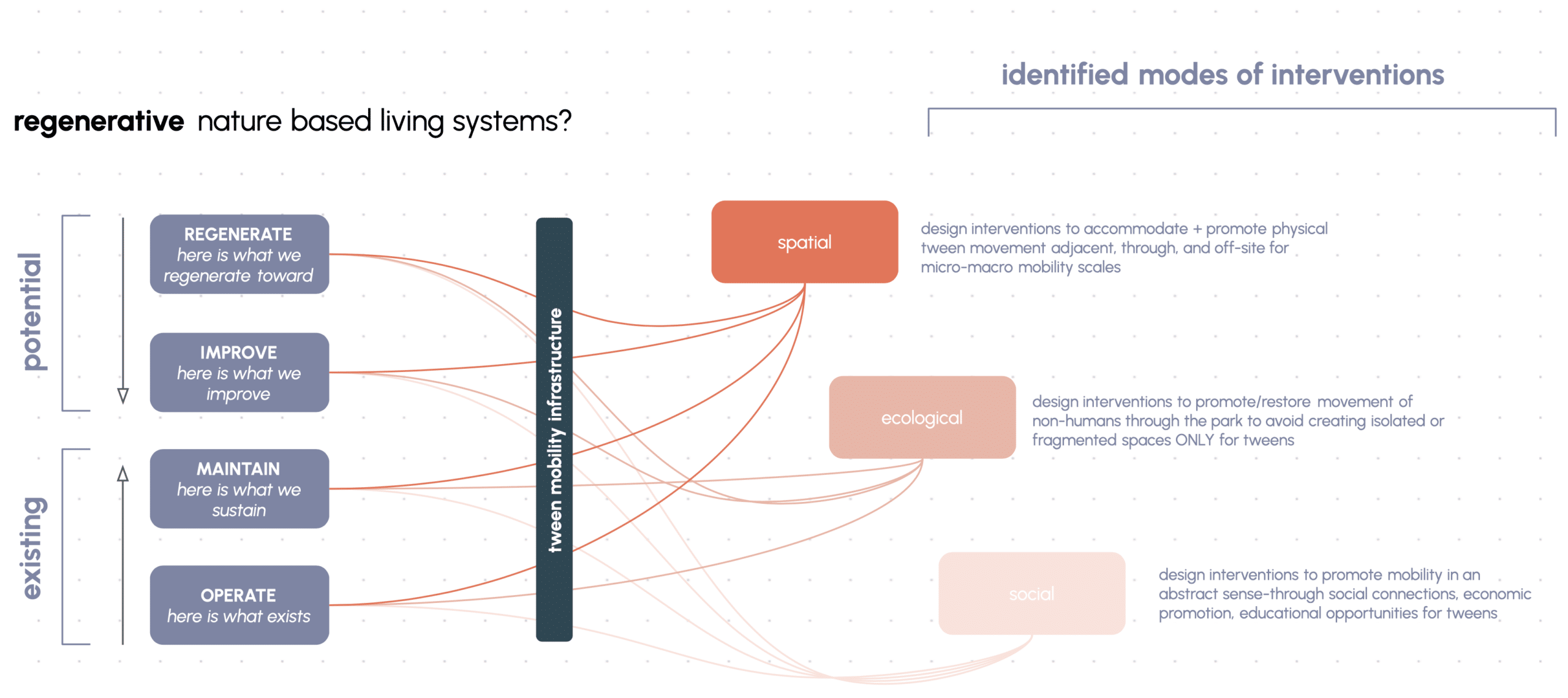
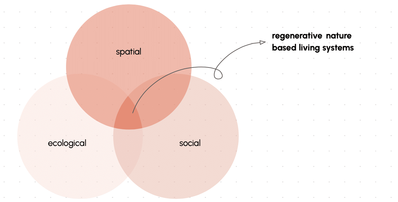
Regenerative nature-based living systems are spatial, ecological and social infrastructures that restore environmental processes while enabling equitable mobility and community agency, thereby generating reinforcing cycles of ecological resilience, economic opportunity and collective identity.
From environmental injustice to regenerative living systems
Our design framework takes a single conceptual move as its foundation: environmental injustice — the compound of industrial corridor, flooded streets, heat exposure, air pollution, and mobility barriers — produces degenerative processes (health risk, social isolation, economic vulnerability). Regenerative intervention can produce the opposite: a reinforcing cycle of ecological resilience, economic opportunity, and collective identity.
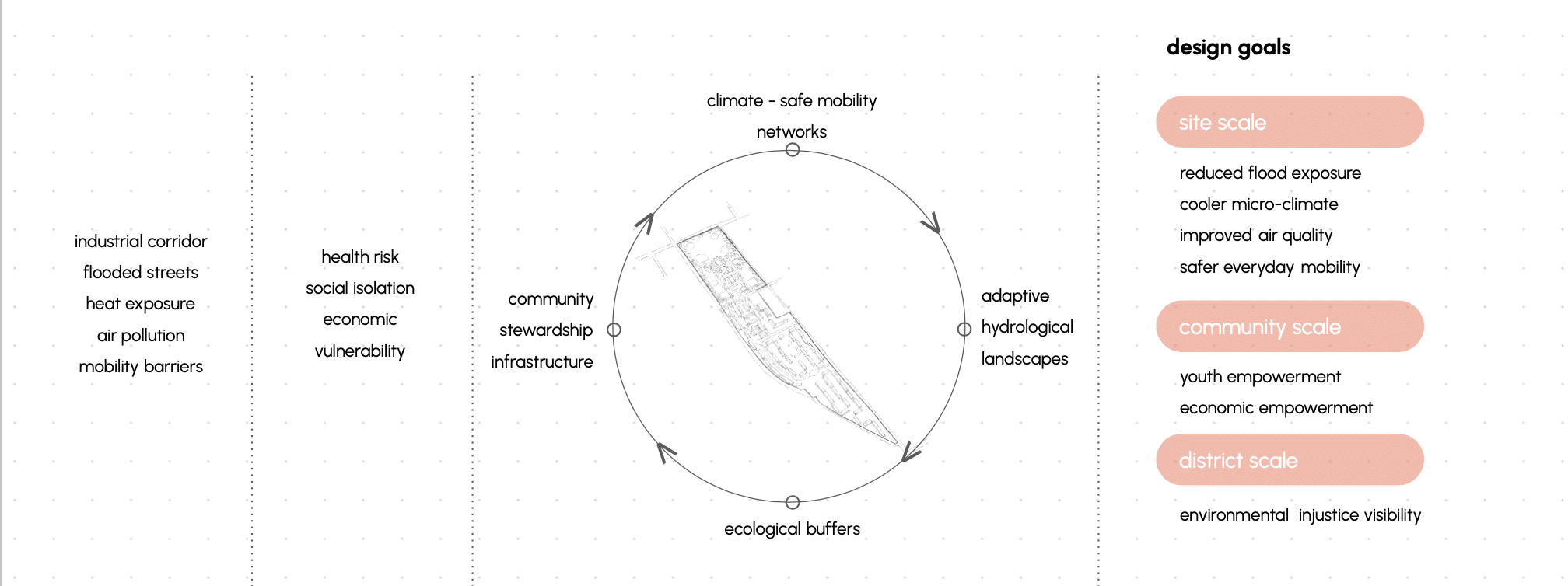
The Four Intervention Pillars
— Climate-safe mobility networks — redesigning the routes tweens use daily into shaded, flood-resilient, safe corridors that simultaneously function as ecological infrastructure.
— Adaptive hydrological landscapes — bioretention basins, vegetated swales, and permeable surfaces that treat flood not as a problem to be drained but as a resource to be managed.
— Ecological buffers — native planting and canopy expansion connecting the site to the broader Calumet Oak Savannah ecological corridor.
— Community stewardship infrastructure — physical and programmatic structures that enable residents particularly tweens to become active stewards of the landscape and derive economic benefit from that stewardship.
Design strategy – Design intervention area identification
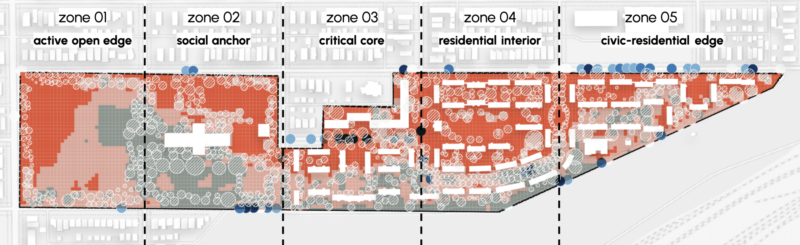
Active open edge :
Lyman Park ball fields and western boundary · Highest heat exposure · Primary tween play zone
Social anchor :
Park interior + recreational centre / field house block · High flood + heat · Key community convergence point
Critical core:
IDA Platt transition zone + central pathways · Highest CEVI score · Primary flood intersection
Residential:
TPH housing blocks · Compound heat + flood + social isolation · Primary tween daily routes
Civic-residential Edge:
Eastern tip + Orville T. Bright adjacency · Air quality + odour stress School route conditions
From environmental injustice to regenerative living systems:
Stakeholder Identification:
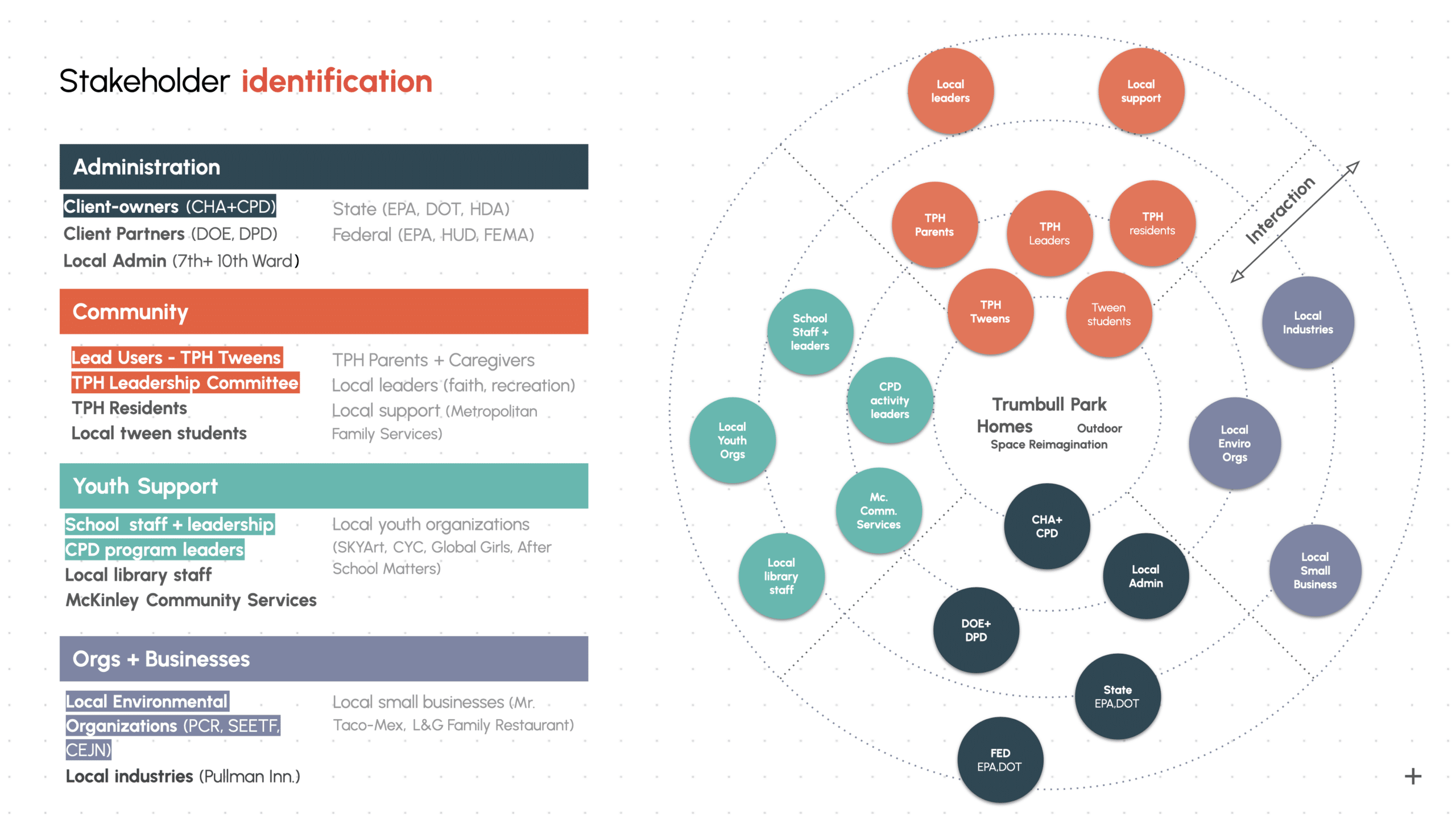
Stakeholder Engagement:
Scribbly Situation
A fast, dynamic, playful and chatty game
AIM: To create a fun, engaging, and creative game to reveal and capture how tweens use and imagine spaces (in Trumbull Hall Park or other Chicago Housing Project).
what is scribbly situation?
Scribble a situation in 60 seconds, then find what’s similar and what’s unique in everyone’s drawings. You all decide what counts — just make sure your explanation impresses the Mayor! So think fast, draw bold! Most points wins.
How can it be implemented ?
The CHA on-site team would reach out to local elementary/middle schools (Orville T. Bright Elementary) about running short workshops to play Situational Scribbles.
The CHA on-site team would facilitate the game in classrooms alongside teachers, and teach kids the game alongside recording observations and qualitative data points in conversations/drawings.
Scribbly Situation is a project of IAAC, Institute for Advanced Architecture of Catalonia developed in the Master in Advanced Architecture 01 – 2025-2026 by the student(s) Lindsay Nier, Chakshu, Reshma Paul and Vijeeth Rao Mandala during the course MUPD01 & MAA01 Serious Games Seminar with Thomas Martin.
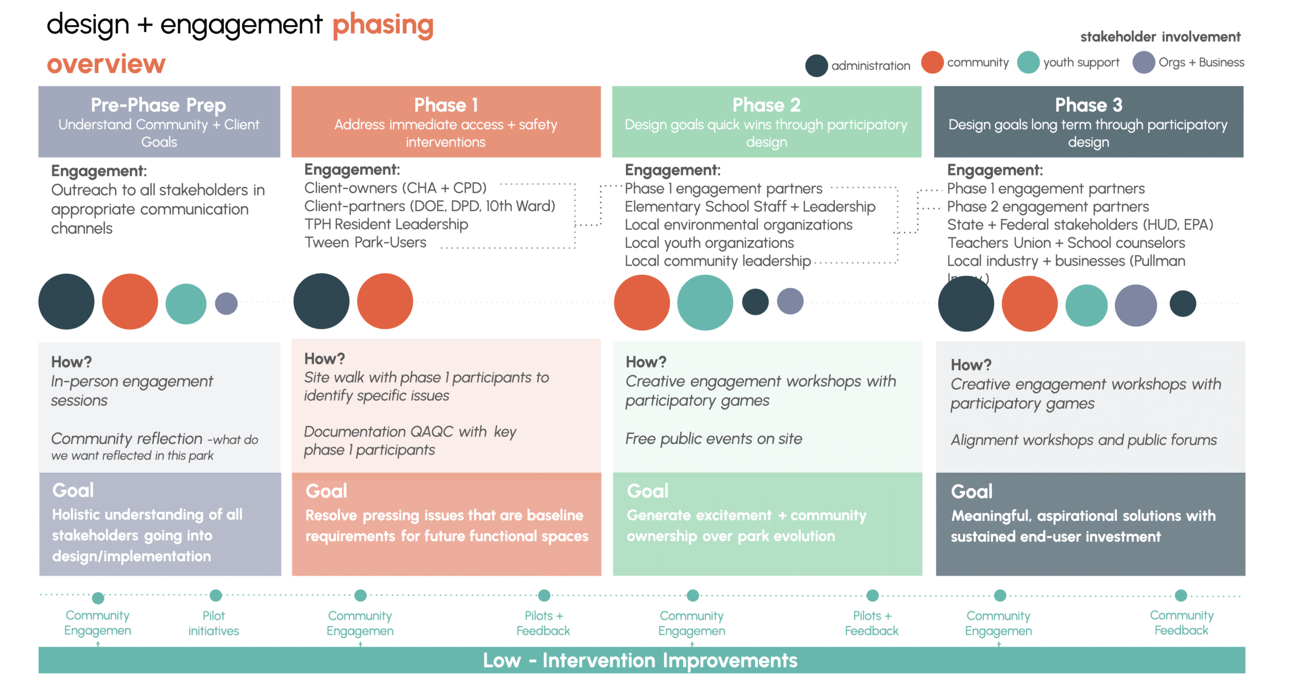
Design + engagement phasing overview
Next Project Steps:
Sources:
ACS 2024 5-year estimates (DP05, S0101) — US Census Bureau.
Chicago CIA Report 2023 — City of Chicago Cumulative Impact Assessment.
CMAP 2019–2023 ACS — Chicago Metropolitan Agency for Planning.
HUD PICTURE December 2024 — US Department of Housing and Urban Development.
Lee, C. (2021). Evaluating EPA’s Definition of Environmental Justice. Environmental Justice, SAGE Publications.
OnTheMap/LODES 2023 (rough estimate) — US Census Bureau Center for Economic Studies.
Chicago Sun-Times (2023). Pullman Innovations air quality violations reporting.
USDA Web Soil Survey — https://websoilsurvey.sc.egov.usda.gov
Google Street View archival imagery (2019, 2025) — flood analysis source imagery.
Roboflow (2024) — image segmentation platform used for computer vision flood detection.
