
Introduction
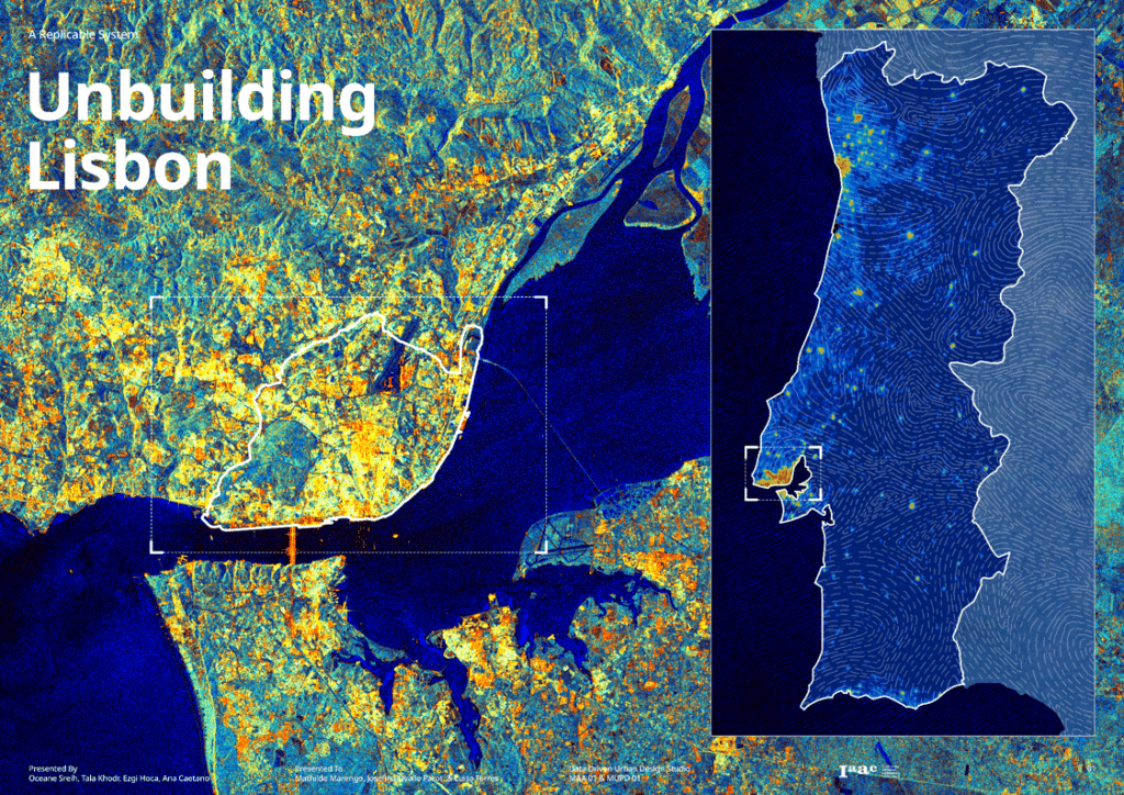
Developed as part of the C40 Reinventing Cities Students Competition, the project Unbuilding Lisbon challenges the conventional response to the housing crisis by questioning the assumption that building more housing is always the most sustainable solution.
https://www.c40reinventingcities.org/en/students/sites-in-competition/maria-droste-site-2105.html
The competition brief proposed the transformation of the Maria Droste Site, a six-hectare vacant plot in Lisbon, into an affordable housing development. Site analysis, however, revealed a broader urban condition in which the housing crisis extends beyond the human population and includes the loss and fragmentation of ecological systems.
Rather than treating these issues independently, Unbuilding Lisbon frames them as two interconnected housing crises: one affecting people and another affecting non-human species.
A Replicable System
Rather than treating Maria Droste as an isolated intervention, the proposal establishes a framework that can be replicated across Lisbon.
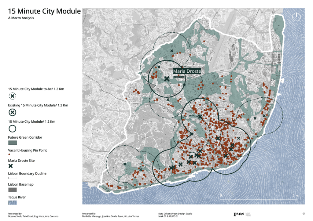
The strategy begins by redefining the site’s role within the city. Instead of functioning as a destination park, Maria Droste becomes the center of a 15-minute urban module, where ecological restoration and housing rehabilitation operate simultaneously. Vacant land is renatured while vacant housing within walking distance is reactivated, creating new habitats for biodiversity and new opportunities for affordable living without additional urban expansion.
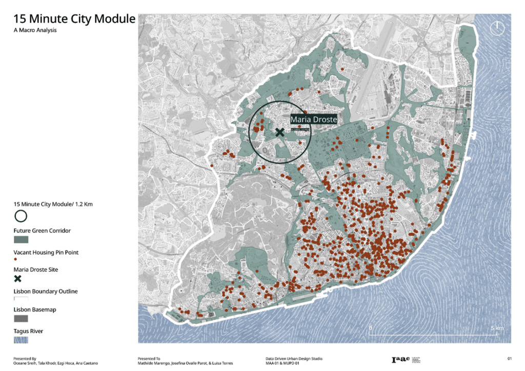
Once the first node is established, the methodology extends beyond the site. Similar locations are identified throughout Lisbon by overlaying vacant land, vacant housing, and the city’s planned Green Corridor Network. New nodes are strategically positioned to reinforce ecological continuity while expanding access to existing housing stock.
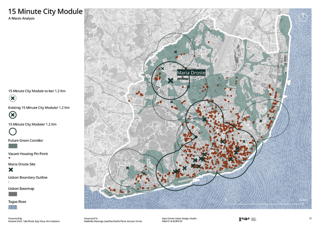
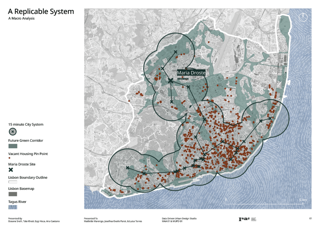
Each node follows the same spatial logic: restoring ecological systems at its center, activating underused buildings within its surrounding neighborhood, and connecting to adjacent nodes through overlapping 15-minute catchments. As additional nodes are introduced, isolated interventions evolve into a continuous city-wide network capable of restoring biodiversity, reconnecting fragmented landscapes, and increasing housing accessibility.
Rather than proposing a single masterplan, Unbuilding Lisbon introduces a scalable urban framework that transforms existing assets into a replicable system of ecological and social regeneration – giving back what decades of financialization have taken away.
Preliminary Analysis
The first stage of the project focused on understanding Lisbon’s housing reality. The analysis revealed a clear contradiction. More than 15,700 families are currently experiencing housing shortages.
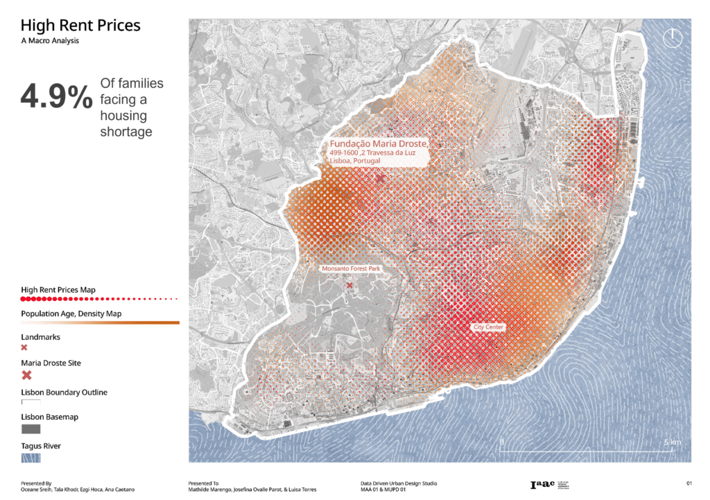
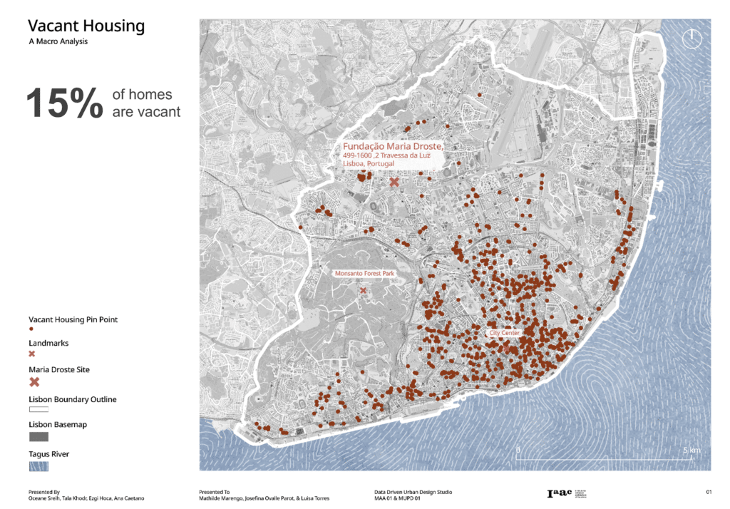
While an estimated 48,000 homes remain vacant across the city. Rather than indicating a lack of housing, these figures expose a mismatch between available buildings and access to them.
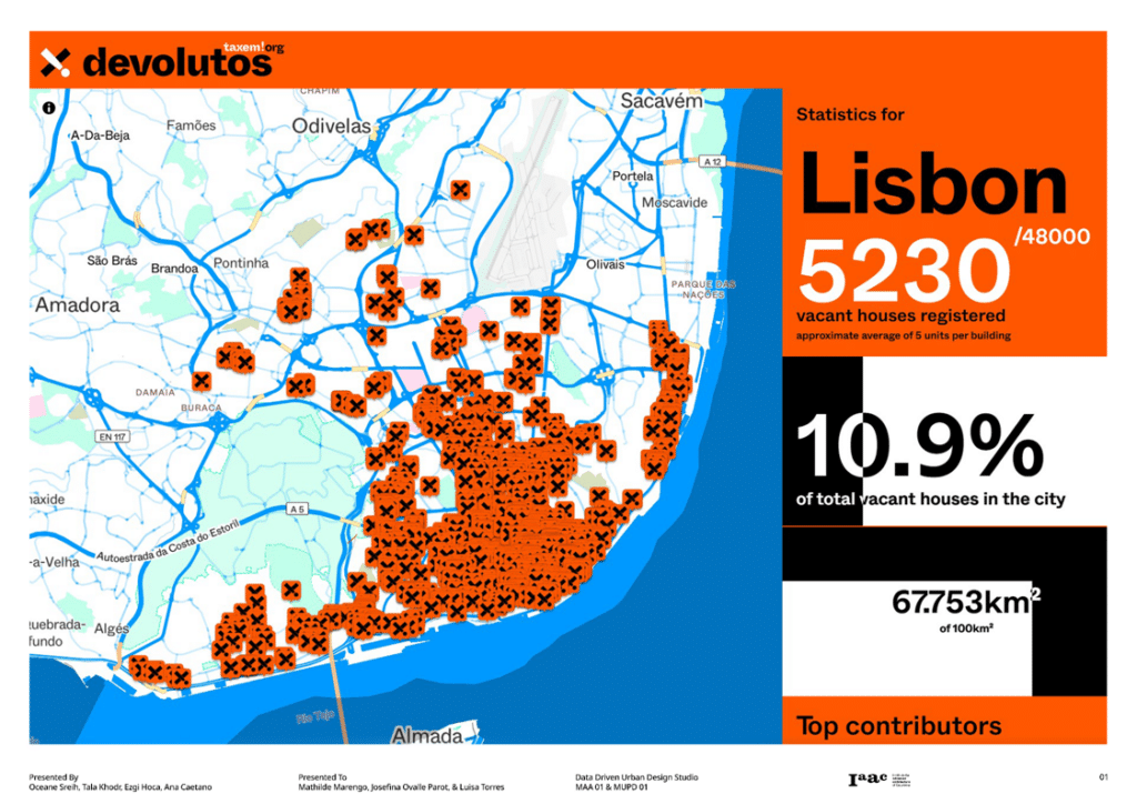
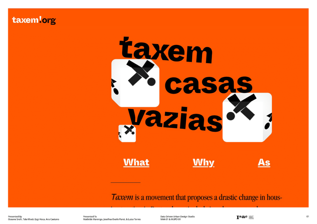
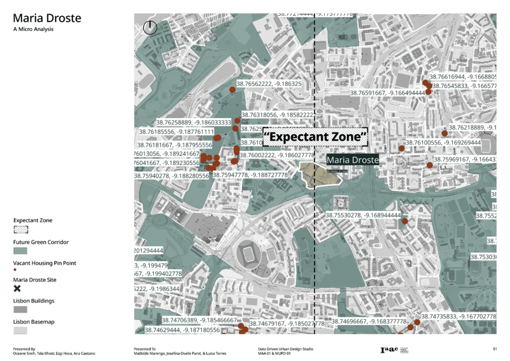
This contradiction has become increasingly visible through Devolutos, a citizen-led platform that allows residents to identify and map vacant buildings across Lisbon. Although the platform documents only part of the city’s vacant housing stock, it makes the issue visible in the public realm and highlights the spatial distribution of underused buildings. Together with the manifesto Taxem! Casas Vazias (“Tax Empty Homes”), it calls for the reactivation of existing housing before further urban expansion.
These findings shifted the direction of the project. Instead of approaching the housing crisis through new construction, the proposal explores how vacant housing can become part of the solution while allowing vacant land to recover as ecological infrastructure.
Two Housing Crises
The housing crisis in Lisbon extends beyond the human population. The same processes that transformed housing into a financial asset also reshaped the city’s ecological systems. As land became increasingly valued for development, native landscapes were progressively replaced by roads, buildings, and heavily managed green spaces.
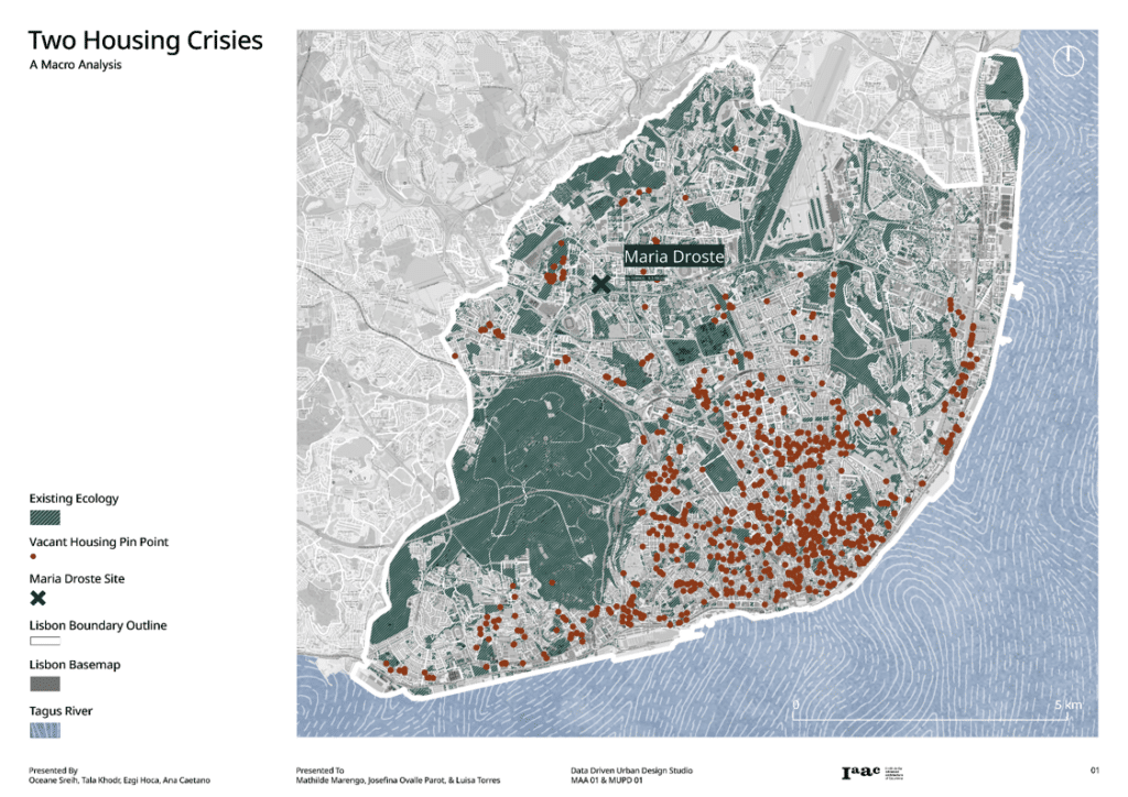
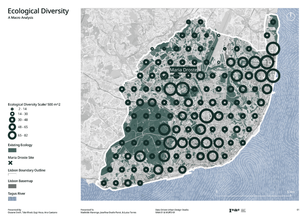
Today, ecological habitats remain fragmented and unevenly distributed across the city. Many public green areas are dominated by grass and monospecies, that do not require intensive maintenance but provide limited ecological value. While these spaces contribute to the urban landscape, they support only a fraction of the biodiversity once present.
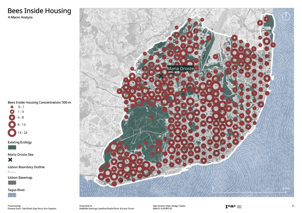
The consequences are already visible. Species that once occupied natural habitats are increasingly adapting to the built environment. Bees, one of Lisbon’s most important pollinators, are frequently found nesting within walls and urban infrastructure after losing suitable habitats elsewhere.
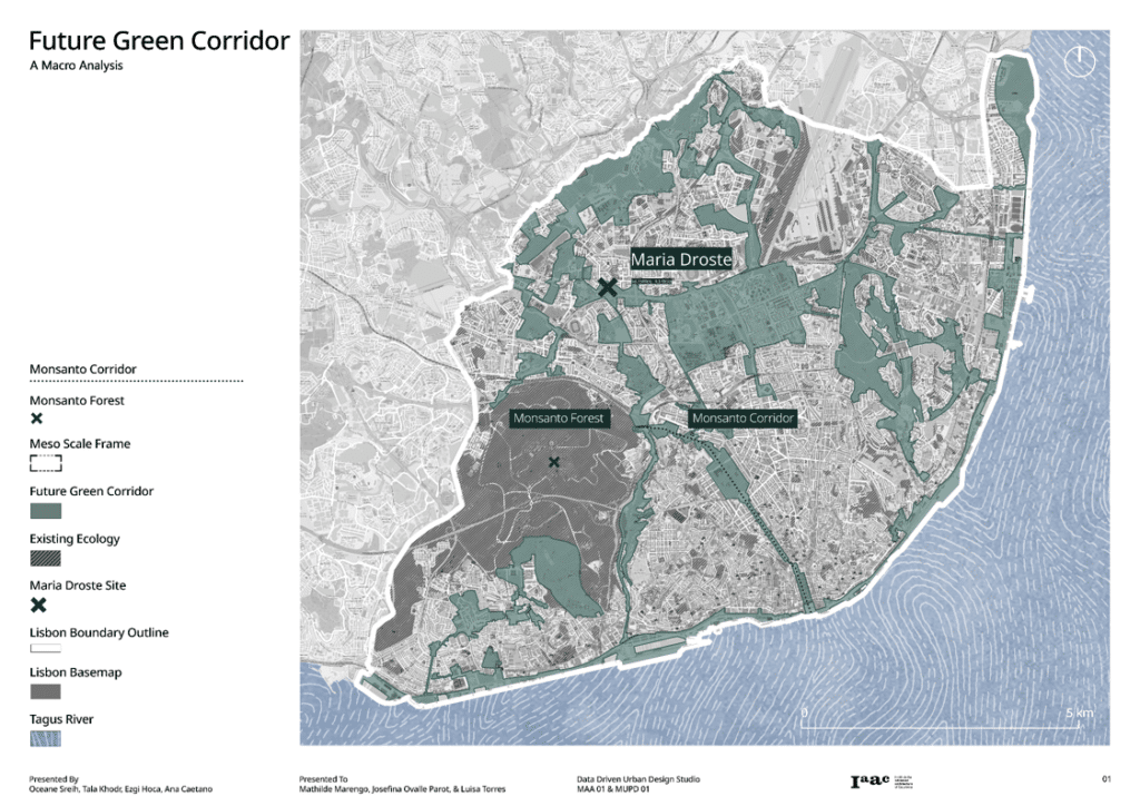
Recognizing this fragmentation, the Municipality of Lisbon has proposed a citywide Green Corridor Network to reconnect ecological systems across the metropolitan area. One of these planned corridors – Central Green Corridor – passes directly through the Maria Droste site, linking it to the Monsanto Corridor and Monsanto Forest and positioning the site as a strategic ecological connection within the city.
The proposal has received strong support from surrounding neighborhoods, where residents have long advocated for preserving the site as public green space instead of introducing new urban development.
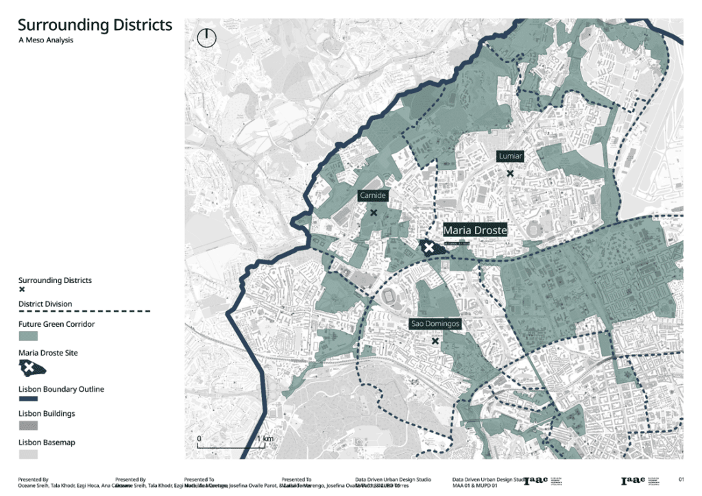
Maria Droste occupies a strategic position within Lisbon’s future Green Corridor Network. At the same time, it faces one of the city’s greatest ecological challenges. The site is bordered by two major highways that connect Lisbon to the airport and to surrounding municipalities. While these roads are essential for urban mobility, they also act as ecological barriers, generating noise, limiting the movement of wildlife, and fragmenting habitats.
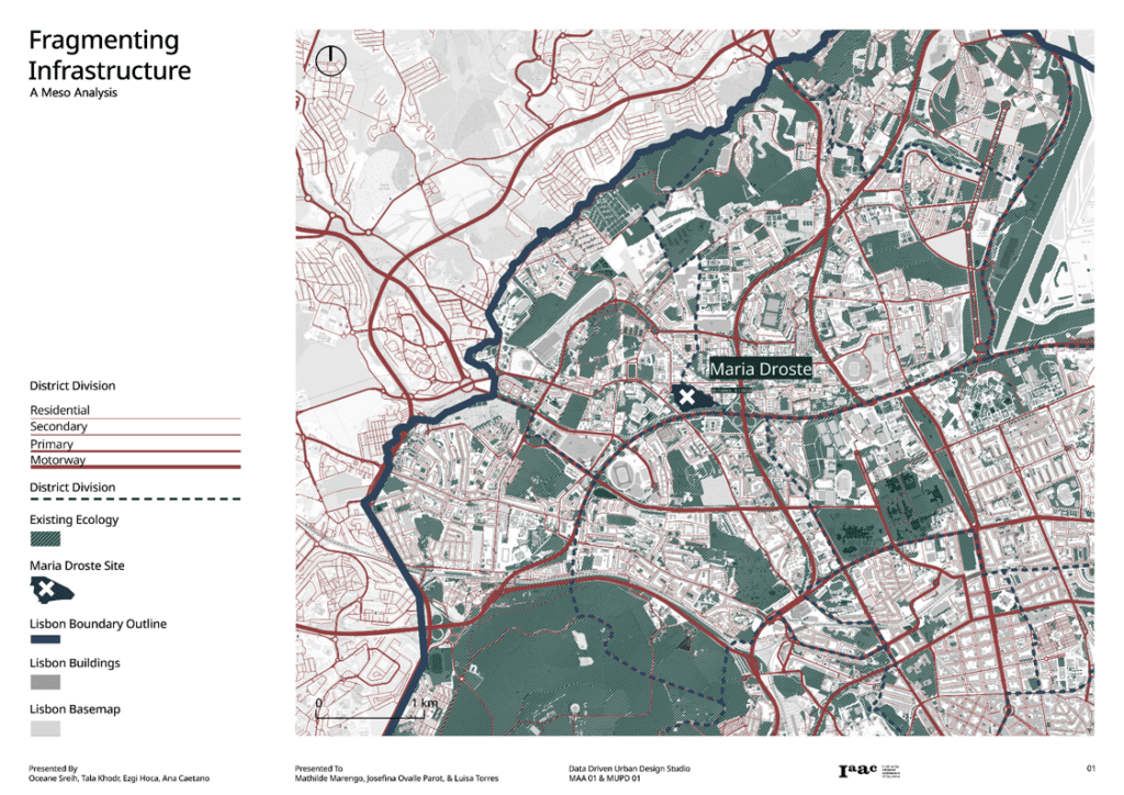
Restoring this site therefore becomes more than creating a new park. It becomes an opportunity to reconnect ecological systems where the urban infrastructure has divided them.
Expectant Zone
Maria Droste has long been designated as an “expectant zone”, reserving the site for future urban development. Over the years, several proposals have sought to transform its six hectares into new housing, reflecting the state’s response to Lisbon’s growing housing demand. At the same time, local residents have consistently defended a different future for the site.
This conflict has shaped the site’s recent history. Public debate over the future of Maria Droste began in 2009, followed by widespread opposition to a market-rate housing proposal that was suspended after community protests in 2015. During this process, residents created PACATA, an association advocating for the preservation of the site and opposing further urbanization. Their argument was simple. Carnide had already received enough concrete. What the neighborhood, and the city, needed was open space.
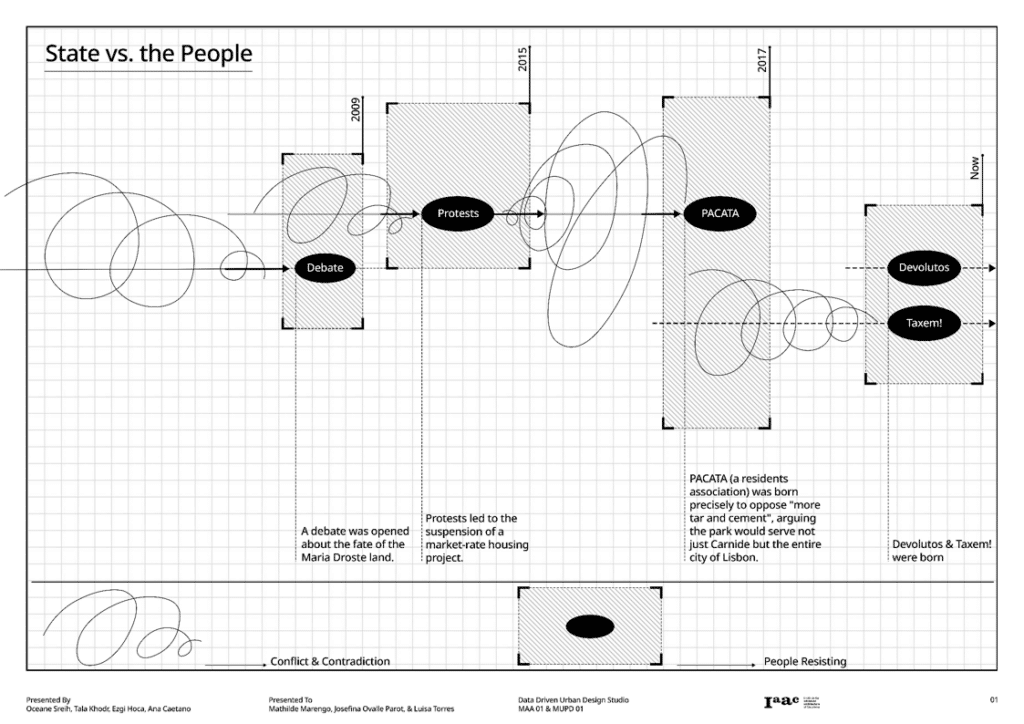
This long-standing debate positioned Maria Droste as more than a vacant site. It became a place where different visions for Lisbon’s future continue to coexist, making it an ideal location to rethink the relationship between housing, ecology, and public space.
From a Site Strategy to a City Strategy
The intervention is conceived as a replicable urban framework rather than an isolated project. Additional nodes are identified throughout Lisbon by combining areas with vacant housing and locations capable of strengthening the city’s future green corridor network.
Each intervention follows the same transformation process:
Vacant → Activated → Inhabited → Replicated
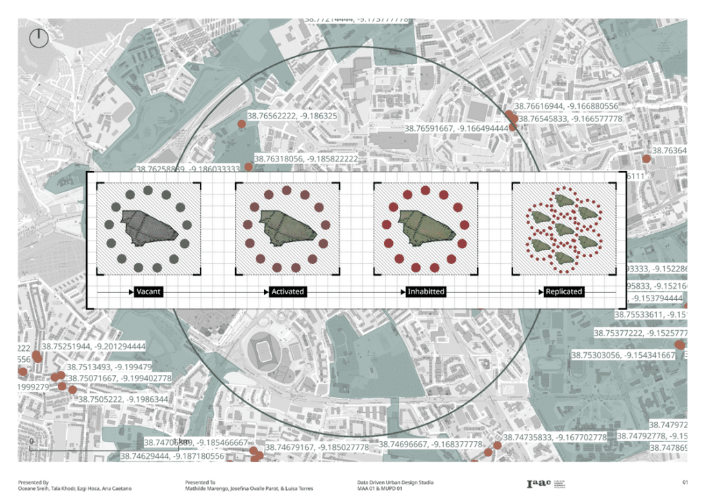
This framework demonstrates how ecological restoration and housing rehabilitation can operate together as a scalable urban strategy.
Why Rehabilitate Instead of Build?
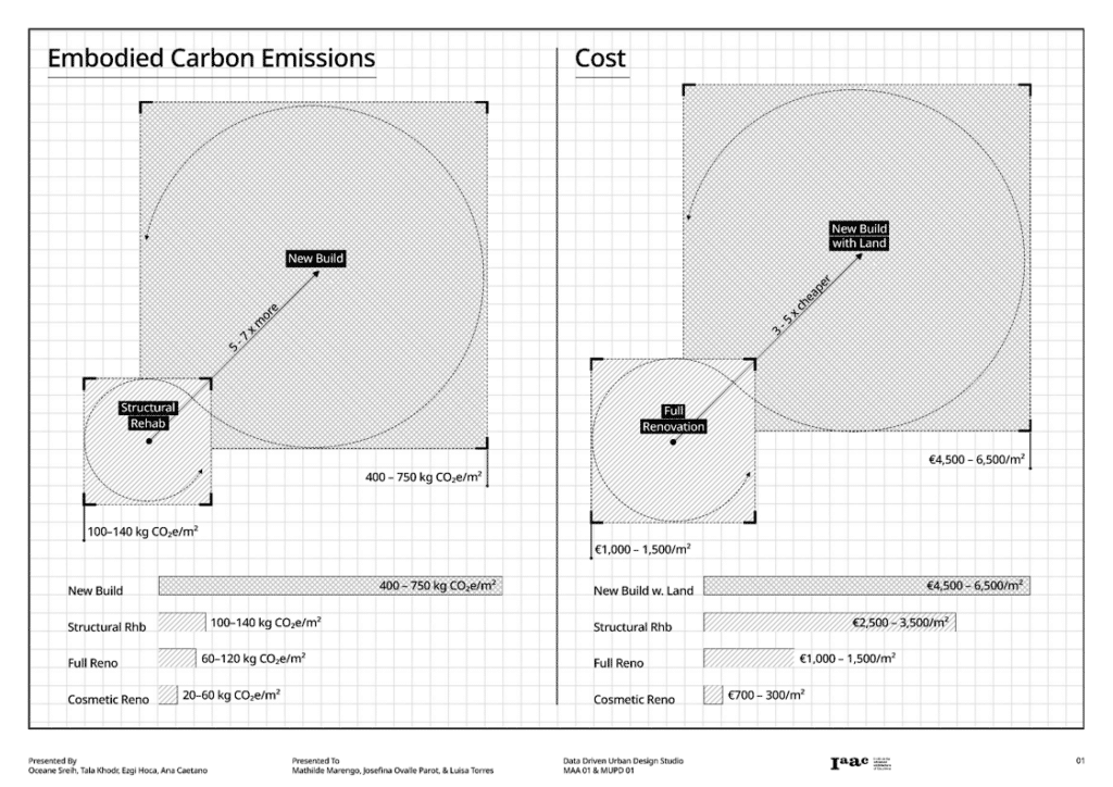
Rehabilitating existing buildings offers clear environmental and economic advantages. Refurbishment generates significantly lower carbon emissions than new construction because it preserves existing structures and avoids the environmental costs associated with demolition and new materials. It is also considerably less expensive, particularly when the cost of land acquisition is considered. Rather than consuming one of the city’s remaining open landscapes, the proposal treats vacant housing as an existing resource and reserves Maria Droste for ecological restoration.
Not all vacant housing, however, can be reactivated in the short term. The analysis identified five typologies of vacancy across Lisbon. Two of these, inheritance disputes and short-term rental properties, remain legally constrained and would require lengthy legal processes or policy changes before becoming available for affordable housing.
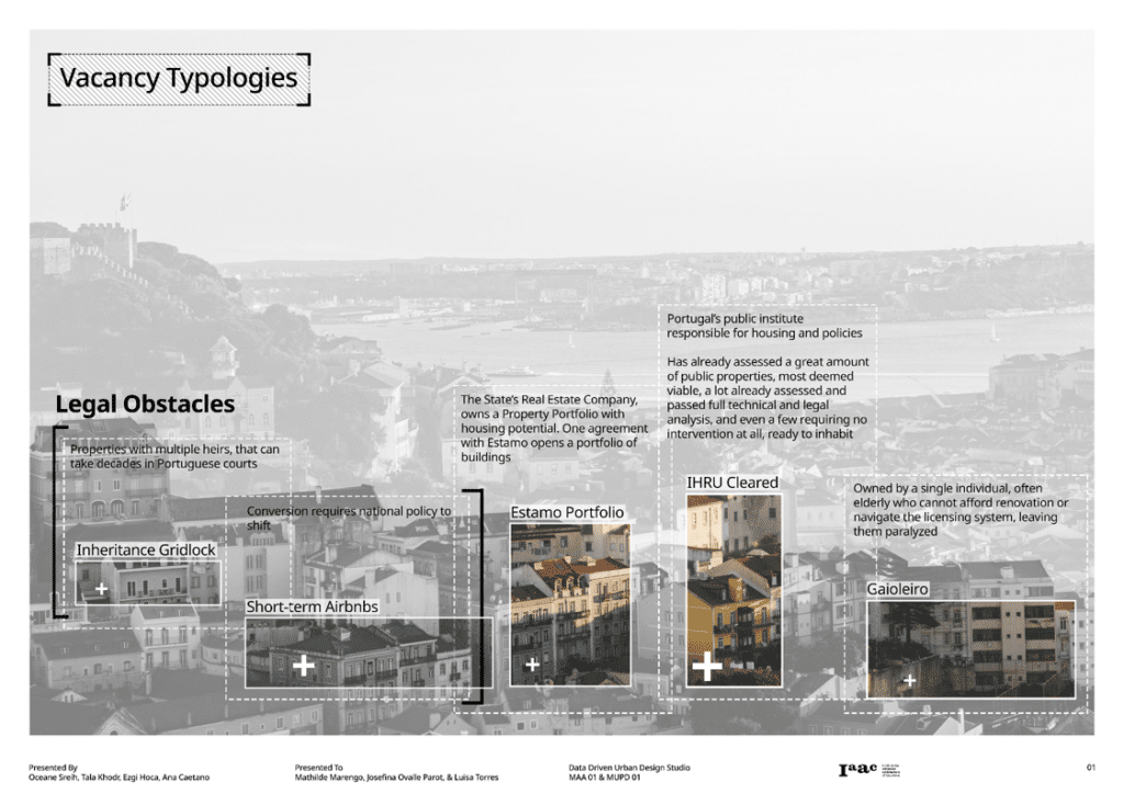
The remaining three typologies represent the most immediately actionable opportunities. These include properties owned by ESTAMO, Portugal’s state-owned real estate company, vacant buildings already assessed by IHRU, the Institute for Housing and Urban Rehabilitation, and Gaioleiro buildings, typically owned by elderly residents who are unable to finance rehabilitation or complete the licensing process. These properties do not depend on inheritance courts or legislative reform. Their activation depends primarily on institutional coordination and political commitment.
Design Strategy
As Lisbon is increasingly exposed to intense rainfall and flash flood events, the landscape strategy began with a preliminary watershed analysis of the Maria Droste site. This analysis revealed a main drainage line running through the centre of the land, where water moves quickly through a narrow and steep channel before accumulating at the lower edge of the site and spilling toward the adjacent highway.
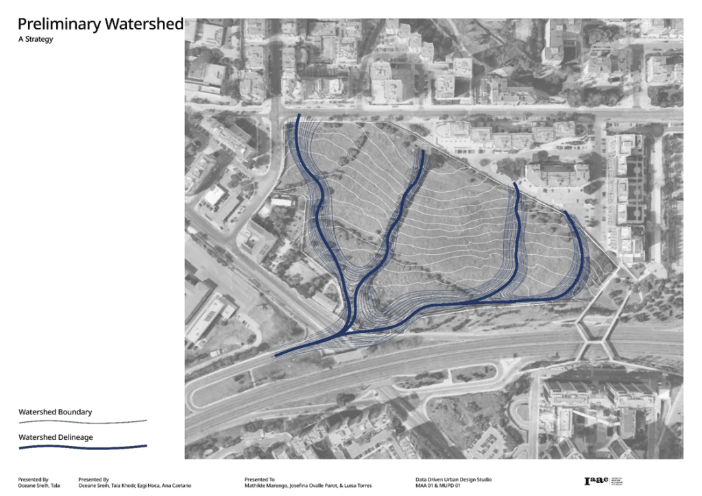
The existing vegetation already suggests an attempt to manage this condition. A vertical line of trees follows the main water flow, helping to slow down runoff through the centre of the site. A second horizontal line of trees crosses the slope, intercepting part of the surface water. However, this cross-shaped system only partially addresses the problem. While some water is slowed or absorbed, much of it is redirected toward the edges of the site, where it continues to flow downhill and collect near the road infrastructure.
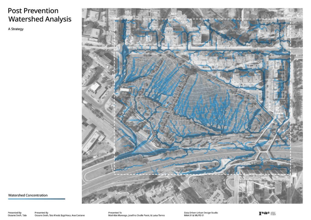
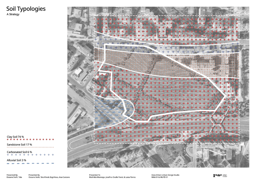
Soil analysis confirmed this reading. The areas most exposed to water accumulation correspond to alluvial soil, formed by sediments carried by running water. Other soil types across the site respond differently to moisture, creating a natural sequence of dry, semi-humid, humid and wetland conditions.
The proposal builds on these existing dynamics rather than replacing them. The vertical tree line is preserved because it already performs an important hydrological function. The horizontal line is reworked through a new two-layer bioswale system, arranged almost as a U-shaped structure that channels water back toward the central drainage line. This allows runoff to slow down, infiltrate and accumulate in designated areas instead of spilling uncontrolled toward the highway.
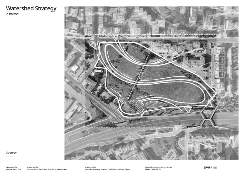
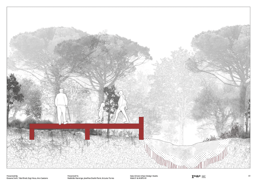
Pedestrian paths are aligned with the bioswales, allowing human movement and water management to work side by side. This keeps circulation clear while avoiding further fragmentation of the ecological areas. The intervention follows the site’s topography, soil conditions and existing water flows, completing a system that was already present but not fully functioning.
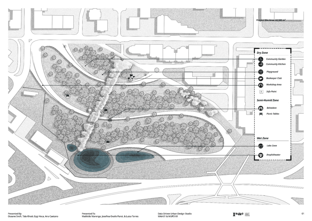
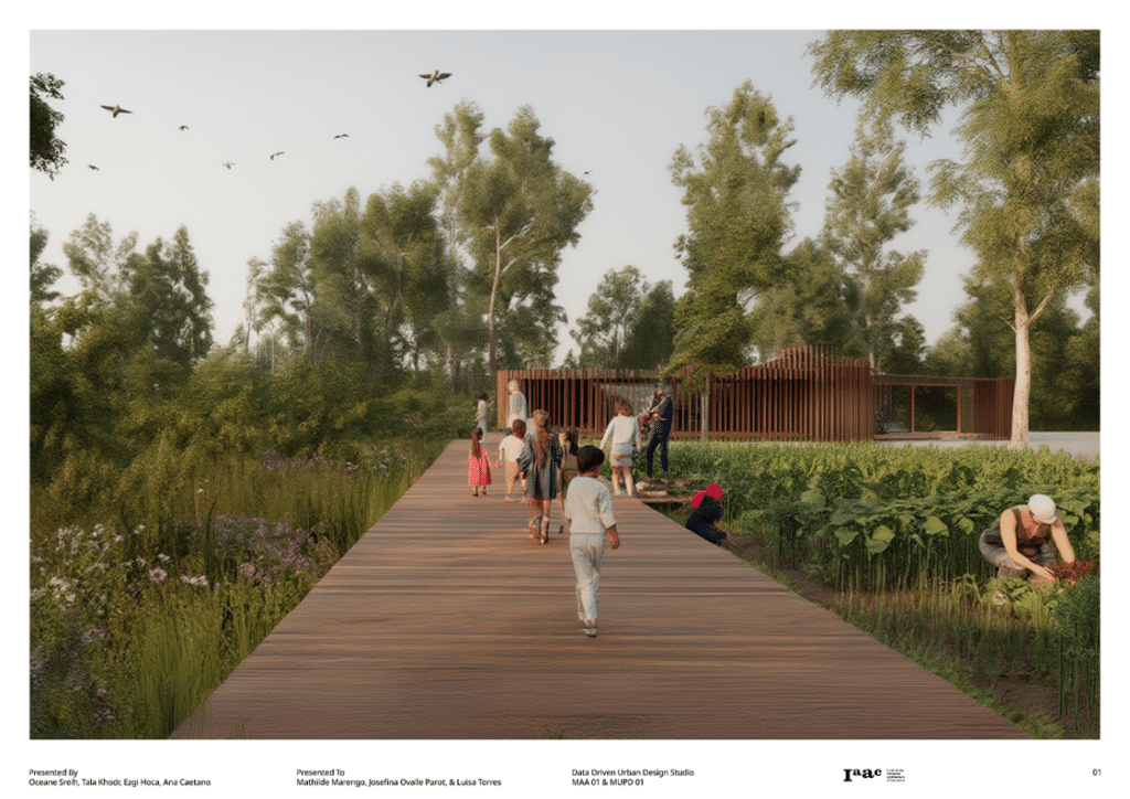
As the bioswales create different levels of humidity, they also define the ecological and programmatic zones of the park. Drier areas can host community gardens, gathering spaces and beekeeping activities closer to the neighborhood. Semi-humid areas support picnic and shaded spaces, while the lower wetland areas become seasonal water basins, habitat zones and amphitheaters during dry periods.
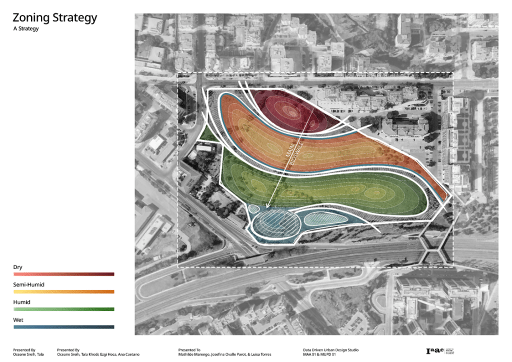
The design follows the site’s existing natural systems rather than imposing a new landscape. Pedestrian paths run alongside the bioswales, allowing circulation and water management to coexist while maintaining ecological continuity across the site. Rainwater is redirected into a series of retention basins, reducing runoff and creating habitats with different moisture conditions.
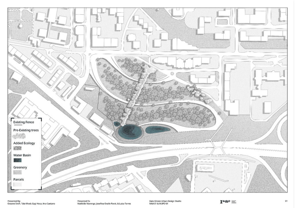
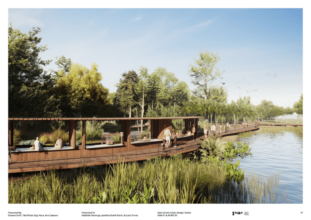
These environmental gradients define both the planting strategy and the program. Native Mediterranean species, including oaks and pines, are distributed according to local soil and water conditions. The driest areas, located closest to the surrounding neighborhoods, accommodate community gardens, outdoor kitchens and a beekeeping centre. Semi-humid zones provide shaded picnic areas, while the lowest parts of the site become wetlands and seasonal lakes. During Lisbon’s dry summer months, some of these basins transform into open-air amphitheaters, allowing the landscape to adapt naturally to seasonal changes.
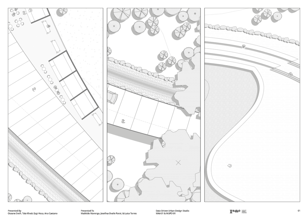
Small timber pavilions are positioned along the main pathways to support community activities and local initiatives. Elevated wooden walkways cross the wetter areas, allowing visitors to experience the landscape without interrupting its ecological processes. Throughout the project, built elements remain secondary to the landscape, supporting its use while preserving its natural dynamics.
Designing Ecological Succession
Rather than presenting a finished park, the proposal establishes the conditions for long-term ecological regeneration. The landscape is designed to evolve through assisted ecological succession, allowing biodiversity and ecosystem functions to develop progressively over time.
The first stage focuses on establishing bioswales, pioneer vegetation and water retention areas. Between two and six years, shrubs, native vegetation and pollinator habitats expand, strengthening ecological interactions across the site. Beyond twelve years, the landscape matures into a diverse and self-sustaining ecosystem with established tree canopies, healthy root systems and increased habitat complexity.
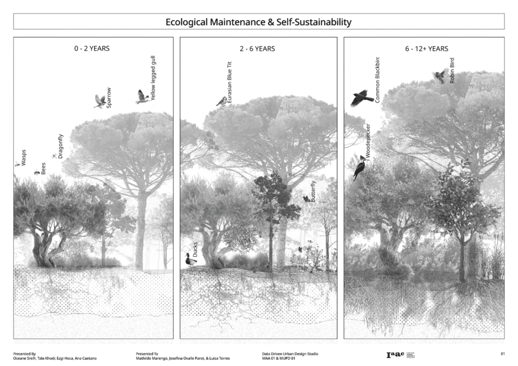
Instead of relying on intensive maintenance, the project encourages natural ecological processes to gradually shape the landscape. Over time, biodiversity increases, maintenance requirements decrease, and Maria Droste evolves from a vacant site into a resilient ecological infrastructure for the city.
