“Costanera Sur” Ecological Reserve gathers the largest amount of biodiversity within the City of Buenos Aires and extends over 350 hectares. It houses more than 2000 animal species, including birds, mammals, amphibians, and reptiles. And it has native vegetation, such as its grasslands of grasslands and alder forests.

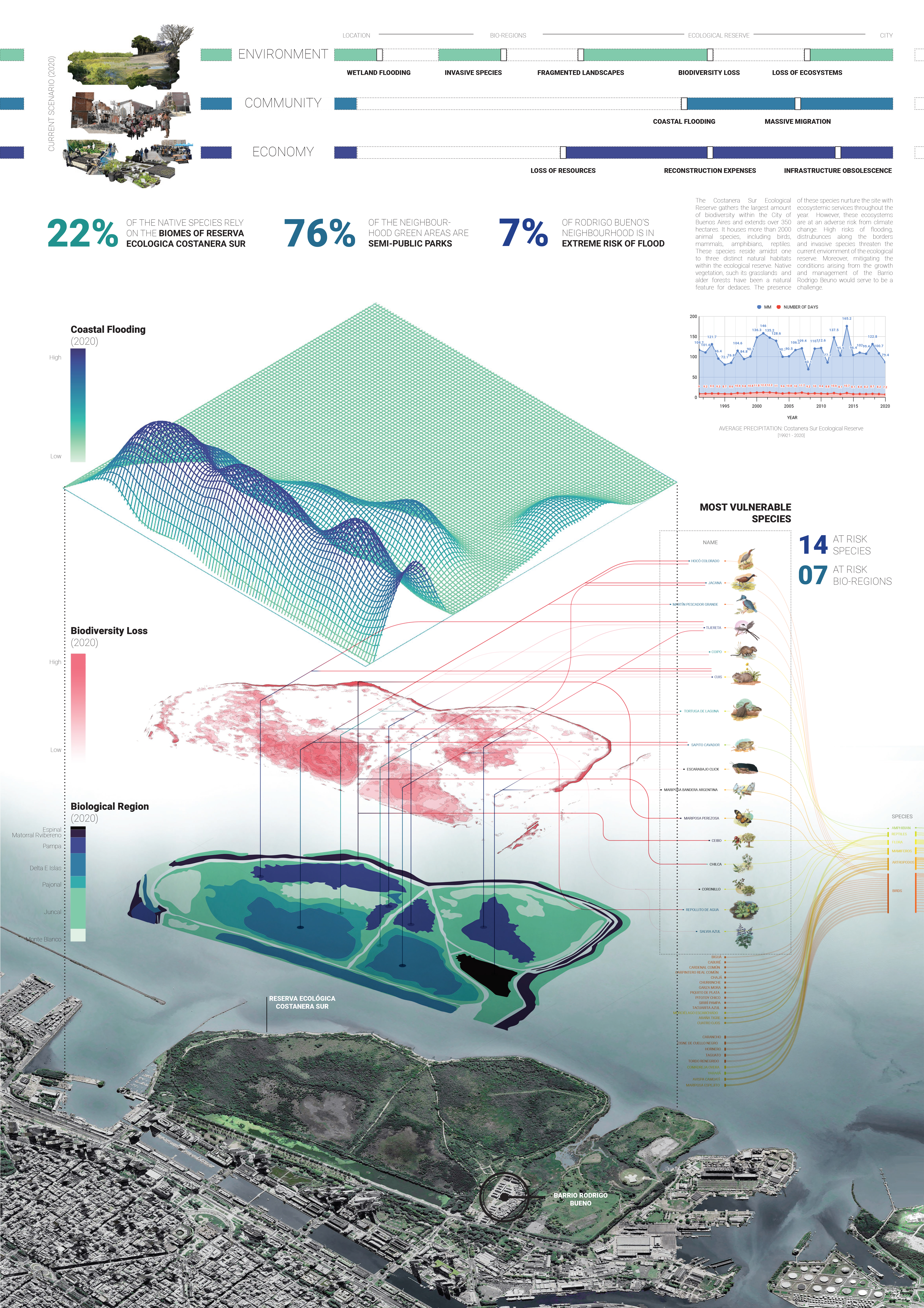
The three interfaces that we focused on at the scale of the ecological reserve are environment, community, and economy.
Across the thresholds of the ecological reserve there exist risk scenarios that we intend to address through a collaborative process, to save the reserve from the ultimate loss of biodiversity, the community from unavoidable migration, and the overall city infrastructure from obsolescence.
BOARD 1 | RISK ASSESSMENT: CURRENT SCENARIO 2020

We understand that the flooding risk areas showcased in board 1 aren’t the same throughout the year as it depends on rainfall too. So on the right, we see the precipitation graph from 1990 to 2020. We identified the wet season to be September and October. Hence, the upcoming data are based on these months’ satellite images.
In order to assess biodiversity loss, we analyzed the green loss based on Landsat 8 Satelite imagery in the wet season of Buenos aires. Using false color image analysis, we understand where the green and blue spaces shrank throughout the years. The result is overlapped with the current biological regions altogether connected to endangered species that correspond only to one type of habitat.
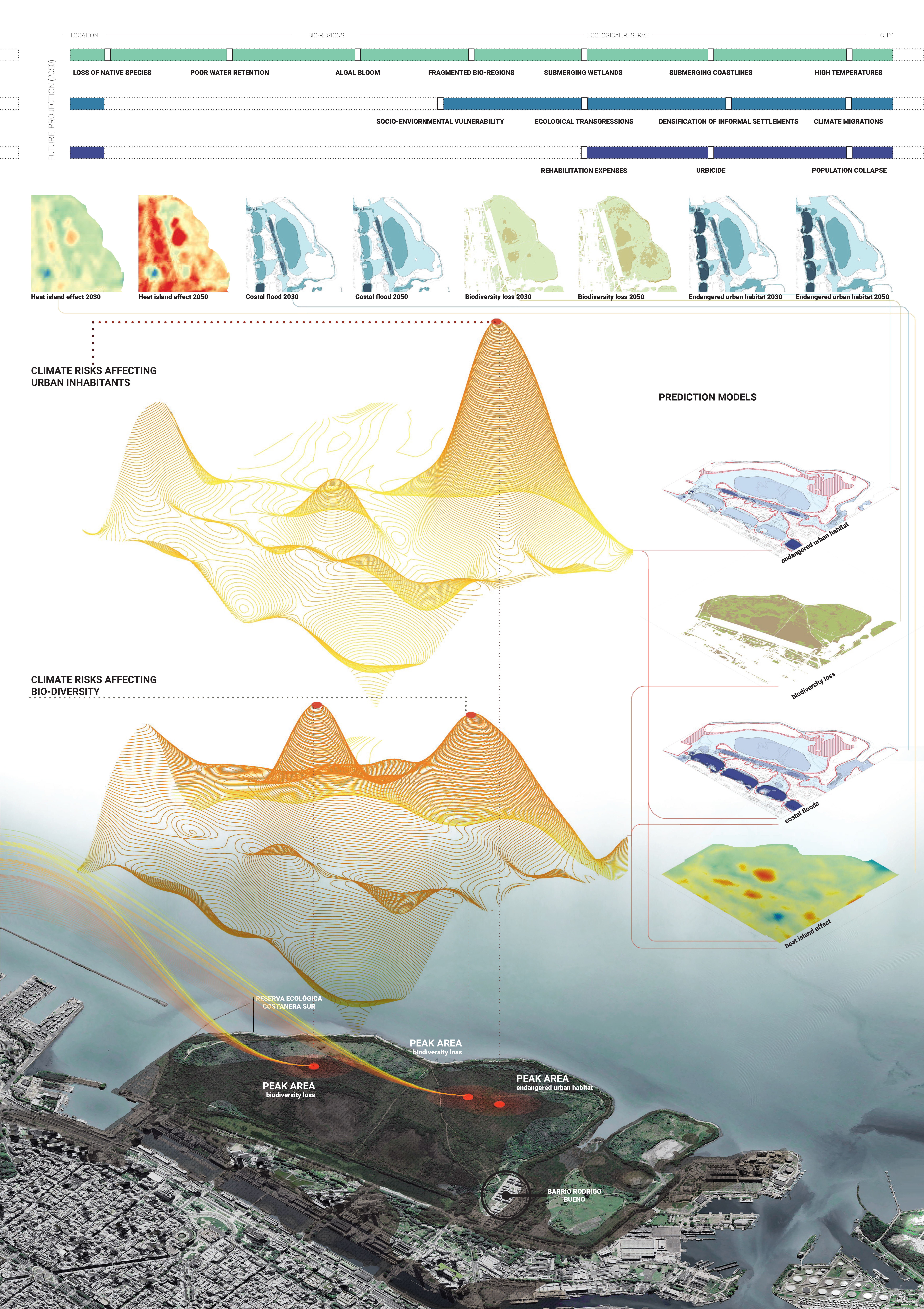
BOARD 2 | RISK ASSESSMENT: FUTURE PROJECTION 2050

We analyzed the risks affecting the reserve in the year 2030 and 2050. The two main issues we looked at were coastal flooding and the heat island effect. And with that, we compared the data on biodiversity loss over these years to understand the reason and area of loss. On our right, we see a combination of these three data which helps us understand the areas with the maximum risks.
We went ahead to follow the same methodology and analyzed the risks to understand its effect on urban habitats.
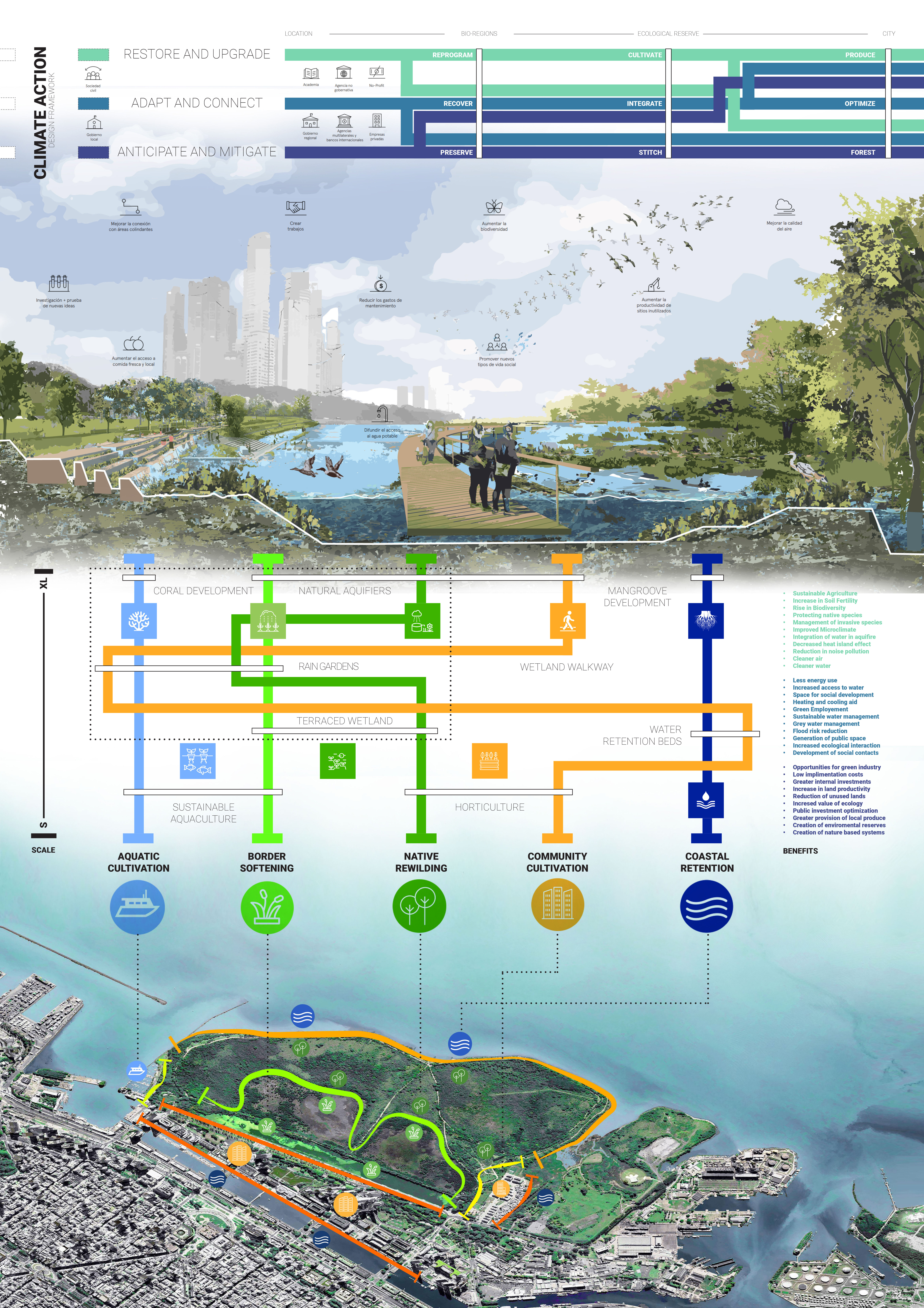
BOARD 3 | CLIMATE ACTION: DESIGN FRAMEWORK
Our climate action plan is rooted in the framework guided by ‘ecological design: Strategies for a vulnerable city. We specifically explore nature-based solutions amidst and peripheral to the ecological reserve in a collaborative structure that enables creative and constructive coming together of the environment and the community. Our interventions are planned to connect the thresholds of specific sites, bio-regions, and the ecological reserve. Using the civic society and local government as catalysts, the strategy is to create a sustainable biodiversity common benefiting the environment, and its biodiversity, and aids the communities to mitigate climate risk.

We have proposed 5 categories of layered interventions along the fragmentation lines that we saw developing as a result of our climate and risk. on the left, we see the scale of the intervention, and on the right its benefits to the environment, community, and the economy as a whole.
1. Coastland Retention:
A state along the coastal peripheries of the site. Using the community to cultivate the soil as natural water retention beds supported via horticulture, and the local municipality to promote community mangrove development, and management programs to safeguard the reserve from long-term flooding.
2. Community Cultivation:
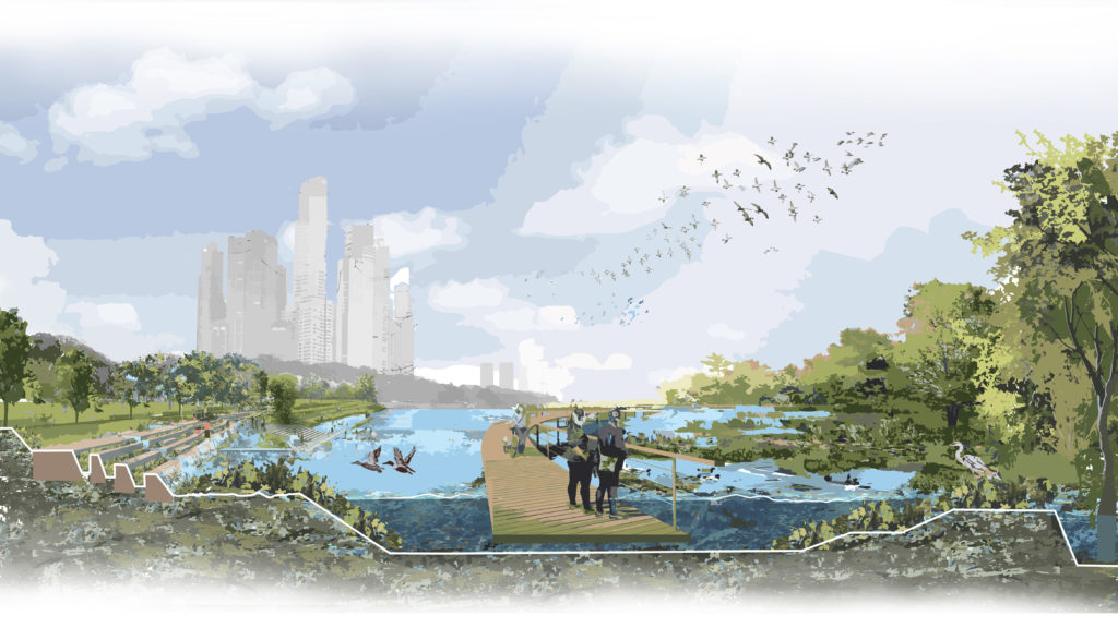
We are looking at integrating communities across thresholds to cultivate land and water for better resource management across different seasons based on specific nature-based interventions like rain gardens. We also propose the development of a walkway to promote community interest in interacting with and preserving native species.
3. Native Rewilding:
The objective is to retain resources on the reserve that promote native species and other supportive biodiversity. Terraced wetland development aids water retention, and filtration and provides bio-regions with year-long resources to support the growing biodiversity. The aim is to develop a system of natural aquifers to establish ecosystemic management of water.
4. Border Softening
This strategy looks at integrating native rewilding, community, and aquatic cultivation along fragmented borders on the site, to make them ecological corridors that support new biodiversity and help the reserve stitch itself together to mitigate the climate risks.
5. Aquatic Cultivation
Perhaps our most ambitious intervention, using the wetlands, coast, and the fishing community neighboring the reserve, the plan is to establish sustainable aquaculture amidst the ecological reserve that in long term includes bringing coral reefs and promoting aquatic biodiversity.
We have tried to provide an open framework for the sustainable development of the ecological reserve where nature-based interventions can be tailored to support ecosystemic endeavors.

Our holistic aim is to encourage the preservation and proliferation of biodiversity across the reserve. the objective is not to protect by isolation but rather preserve via integration. Our methodology, the framework that guides it and our specific interventions focus on community and nature-based solutions that have a compounding long-term effect over moderating microclimatic conditions as well as generate a series of positive externalities of production for the urban economy of a growing metropolis like Buenos aires.

