
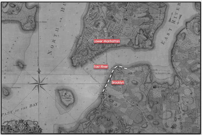
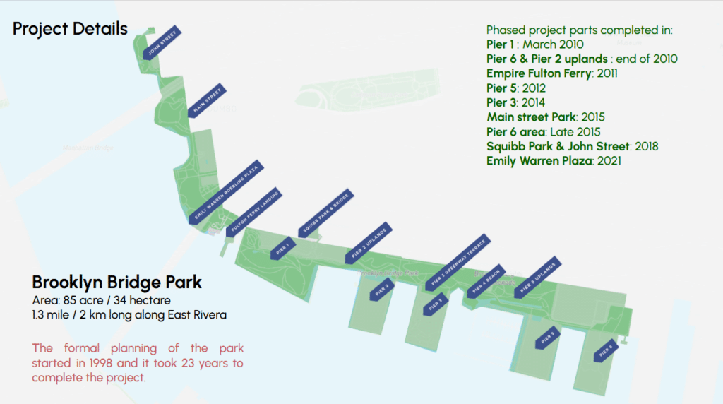
The Brooklyn Bridge Park is located along the Brooklyn waterfront of the East River, between DUMBO and Atlantic Avenue, and it spans about 85 acres (0.34 km²), stretching roughly 2 kilometers along the shoreline. That alone makes it one of New York City’s most significant post-industrial waterfront transformations. The park was developed in phases between 2008 and 2020, gradually converting former industrial piers into a continuous public landscape.
Now, given how large the park is, we knew we had to narrow our focus — and Pier 1 felt like the obvious choice. It’s the largest and most visited pier in the park, serving as a primary entry point with everything from lawns and playgrounds to wetlands and scenic viewpoints. A big part of its foot traffic comes from visitors who’ve just crossed the Brooklyn Bridge and continue straight into the park.
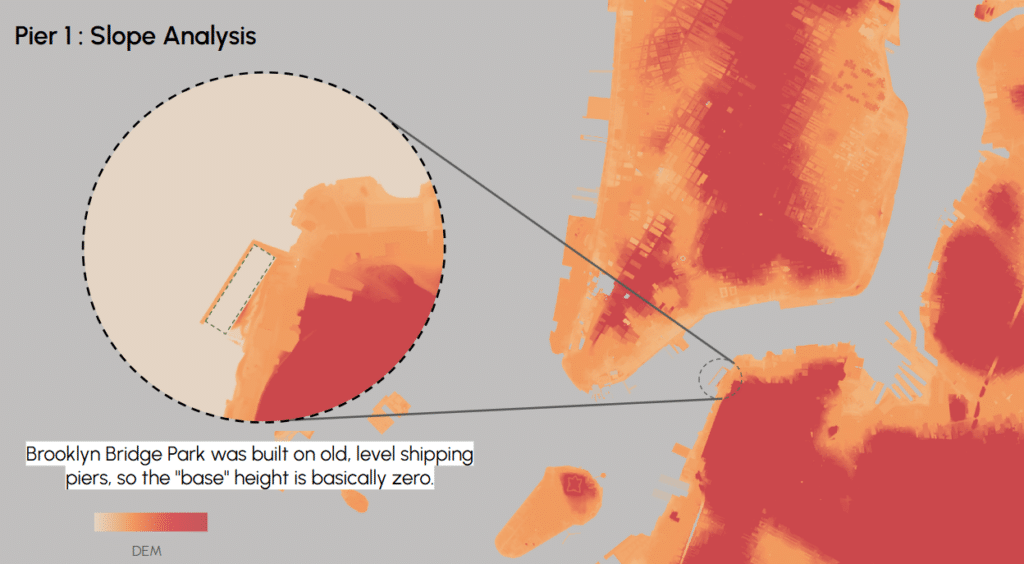
Given the pier’s industrial history, it wasn’t surprising to find that the base is nearly flat — it’s built on landfill, after all. But what designers did was introduce artificial slopes and landforms to create visual interest, improve drainage, and guide how people move through the space. These subtle changes in elevation turn out to matter a lot, both for how vegetation is distributed and for how people choose to occupy different parts of the pier.
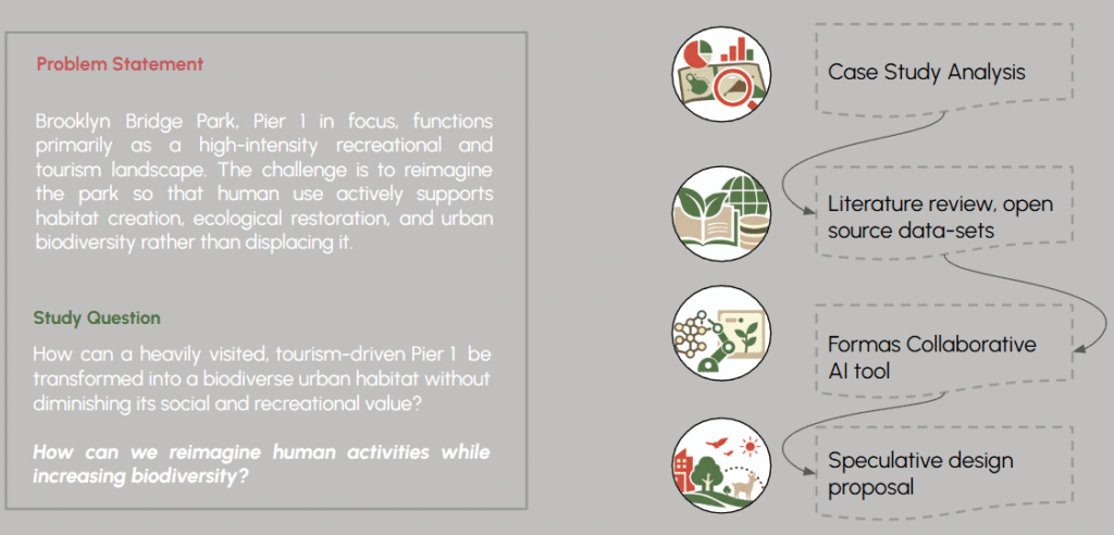
Brooklyn Bridge Park functions mainly as a high-intensity recreational landscape, placing pressure on its ecological systems. Our challenge was to ask how human use can support habitat creation rather than displace it — and how a heavily visited Pier 1 can become biodiverse without losing its social value. To address this, we reviewed park datasets on planting and land use, mapped tree distribution and succession patterns, analyzed movement using Street View, and used AI-assisted tools for rule-based design testing. Together, these methods gave us an integrated ecological and social understanding of the site.
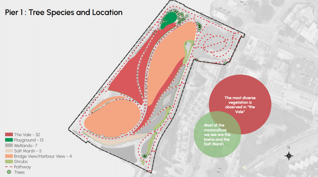
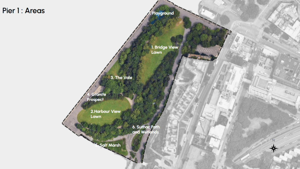
Once we understood the topography, the design of pier 1 made a lot of sense. The two lawns — Bridge View and Harbor View — are the main social anchors, offering iconic views of Manhattan and the Statue of Liberty respectively. Then there’s The Vale, the densest forested area on the pier, which provides shade, acoustic buffering from the city, and layered canopy cover for local bird life. Granite Prospect is a large salvaged-granite staircase that functions both as an amphitheater and a key circulation node. Down at the southern edge, the Salt Marsh is a complex habitat built to filter water and support native species. The Sumac Path and Wetlands weave the park’s irrigation and filtration systems together with dense native planting. And finally, the Playground offers a dedicated active recreation zone integrated into the landform. All told, about 70% of Pier 1 is green space, with the rest paved
Before moving into the planting strategy, we mapped tree diversity across these zones by creating a gradient diagram based on the number of species present in each area. This helped us see which parts of the pier function as monocultures and which support higher biodiversity, giving us a clearer ecological reading of the site.
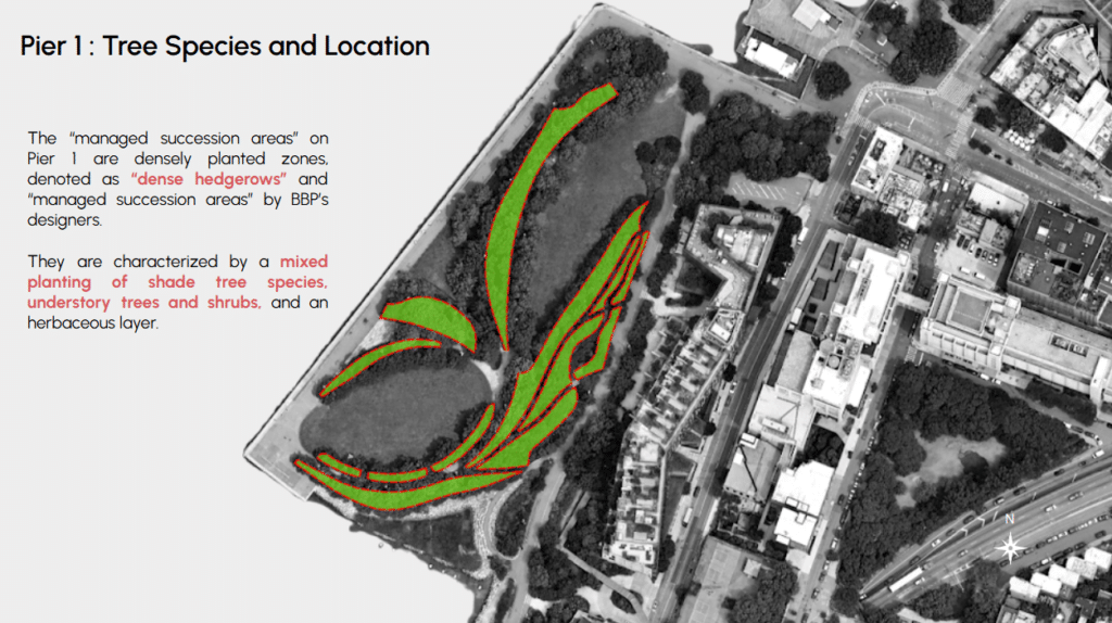
One of the most interesting things about Pier 1 is its planting strategy — specifically, the use of managed succession. The dense hedgerows along The Vale’s perimeter for acoustic buffering and microclimate control, as well as vertical stratification throughout: a canopy layer of dominant shade trees on top, an understory of smaller trees and shrubs in the middle, and a herbaceous ground layer of perennials and grasses below. Each layer plays a role, and together they create a surprisingly complex ecological structure for an urban pier.
In the park, we can see the growth patterns in the hedgerows, – which is not natural, but rather very much curated. Triplet clump hedgerow strategy using Honey locust, Kentucky Coffee tree, and London Planetree. Trees are intentionally thinned over decades; surviving specimens gain dramatically more root volume and canopy space. Here, the Young trees were initially planted in dense clusters, creating hedge-like structures that guide movement and define space. Over time, selective thinning allows stronger trees to mature, forming open groves with layered canopies. This approach balances immediate spatial structure with long-term ecological resilience.
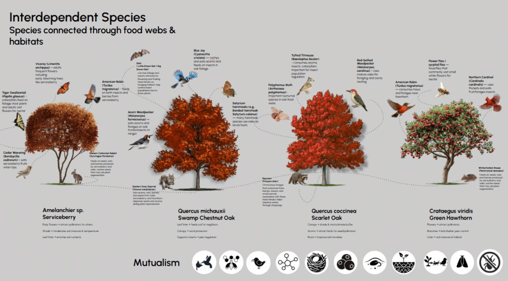
Swamp Chestnut Oak, Scarlet Oak, Serviceberry, and Green Hawthorn support wildlife by providing acorns, berries, flowers, and foliage for birds, butterflies, moths, and hoverflies. In return, these animals disperse seeds, pollinate flowers, and regulate insects, reinforcing food webs and forest resilience. Mammals like squirrels, raccoons, rabbits, and bats feed on fruits and nuts while aiding seed dispersal and soil enrichment. Together, these plants and animals create interconnected habitats, supporting reproduction, survival, and ecosystem connectivity across the park. These species appeared most frequently in the dataset, indicating their dominant presence on site.
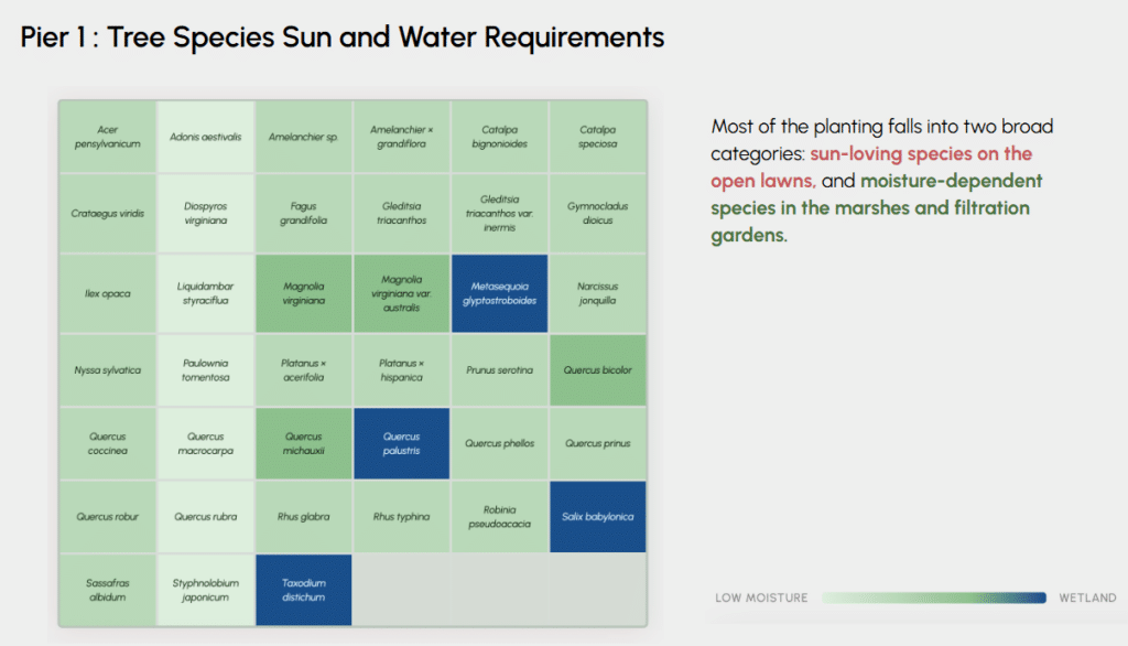
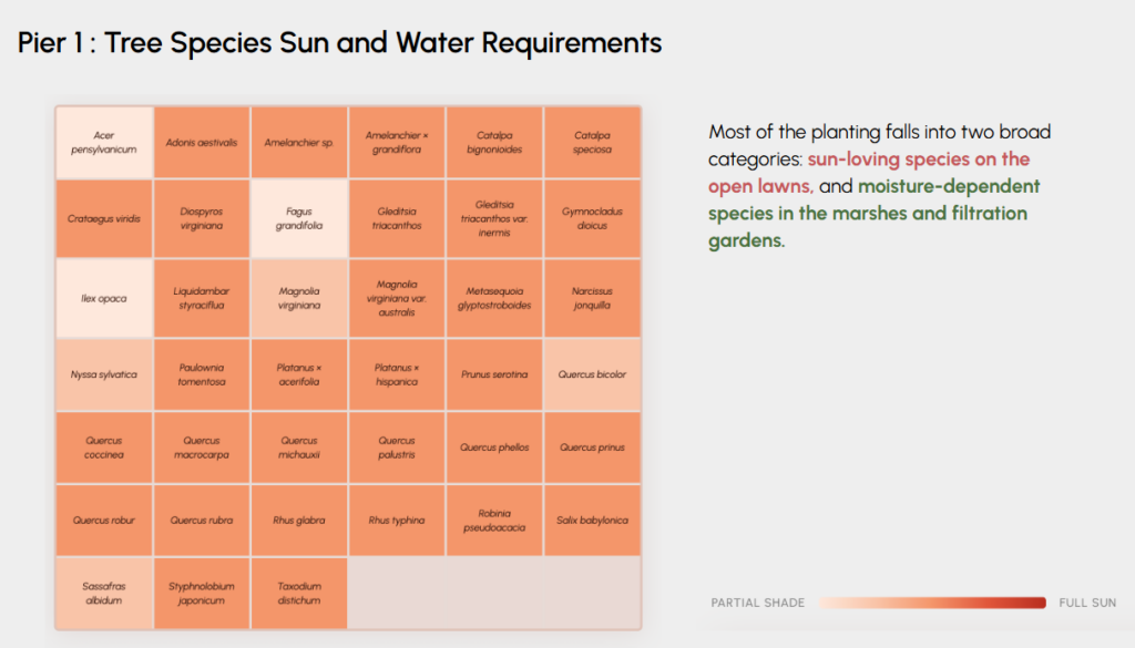
In large part, the way the parks and these rows look comes down to what the plants need. Because the pier is a flat, man-made surface, designers had to build artificial hills and valleys to create the right conditions for each species. Most of the planting falls into two broad categories: sun-loving species on the open lawns, and moisture-dependent species in the marshes and filtration gardens. The slopes, then, aren’t just aesthetic — they actively channel rainwater toward the plants that need it most. It’s essentially a system designed to turn a hot, exposed industrial pier into a cooler, shaded landscape, and the survival of the 500+ trees here depends on that balance. It’s also interesting to note that we don’t have plants that need high maintenance because of the high demand of the sun. so we don’t see the red here.
What this tells us is that the trees on Pier 1 are fundamentally different from trees in the wild. In natural environments, growth is irregular and multi-layered — messy, in the best sense. Here, everything is intentional. Layering is kept moderate to maintain safety and clear sightlines, and succession is managed rather than left to chance. Ultimately, Pier 1 is a space where human decisions govern how nature grows and evolves — which is both its strength and the tension at the heart of our project.
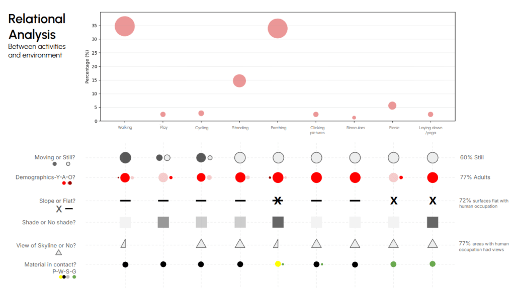
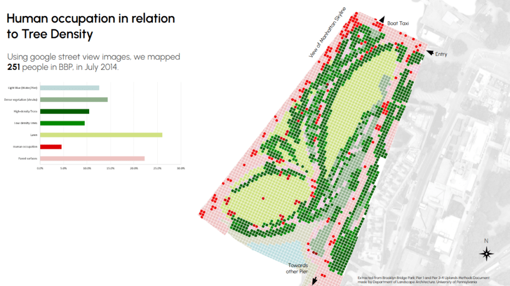
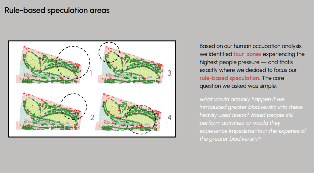
We took our ecological analysis further by checking out how people really use Pier 1. We gridded up site photos—red pixels for busy, high-traffic spots; pink for the chill zones. Overlaying that with the plants showed us right where people and nature clash.We mapped activities too: walking, biking, picnics, snapping pics. Flat spots draw crowds moving around, while slopes and high points are perfect for sitting, chilling, and taking it all in. It really drives home how the land’s shape steers what we do—super useful for any redesign.
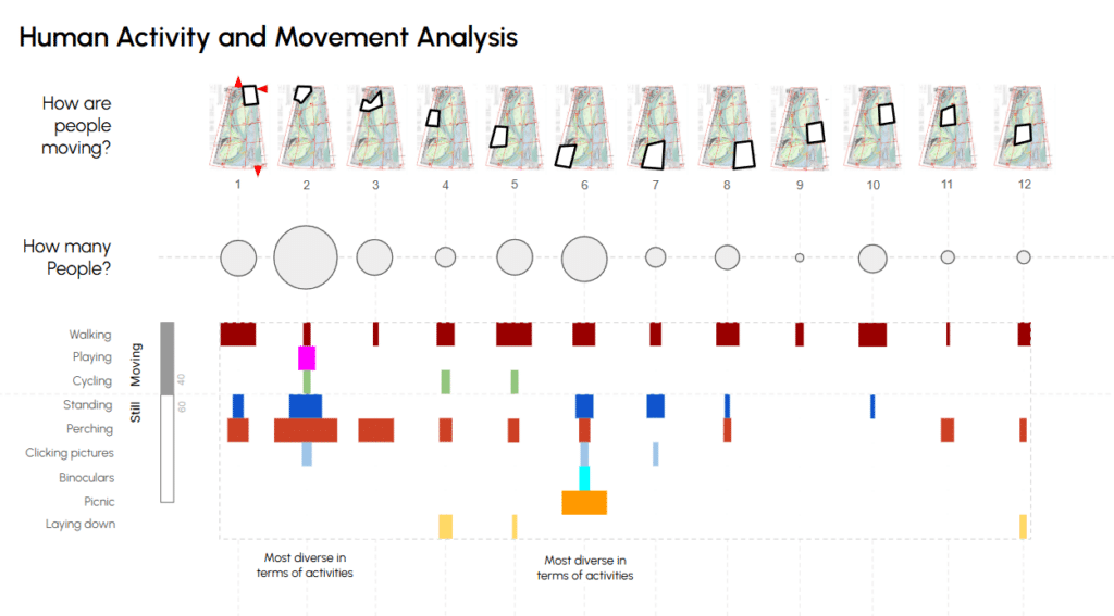
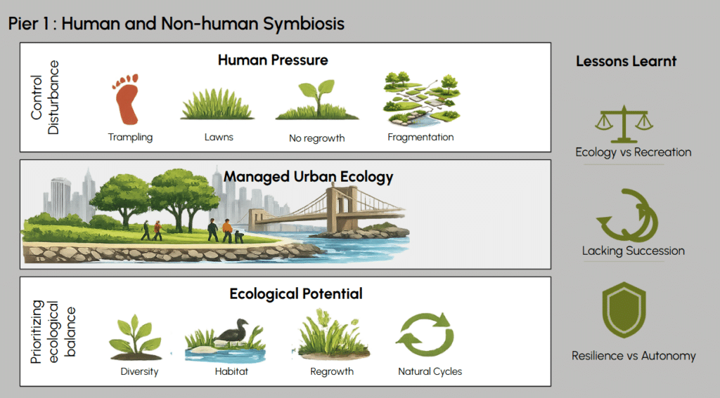
At its core, the human-nature vibe here is all about control. Plants are carefully managed, wild growth is kept in check, and fun/recreation comes first, which dials down real biodiversity. The park bounces back thanks to diverse species and smart engineering, but it’s mostly artificial resilience, not truly self-sustaining. Pier 1 feels tough and lively, yet held back ecologically—calling for a better balance between us hanging out and letting nature do its thing.
This park currently allocates 67% of its area to green space and 33% to human infrastructure. However, 76% of these vegetated areas are actively used by people, leaving only 24% as undisturbed ecological refuge. This creates pressure on biodiversity, as wildlife requires safe, low-disturbance zones. Our proposal transforms portions of this 76% shared space into biodiversity-enhanced landscapes.
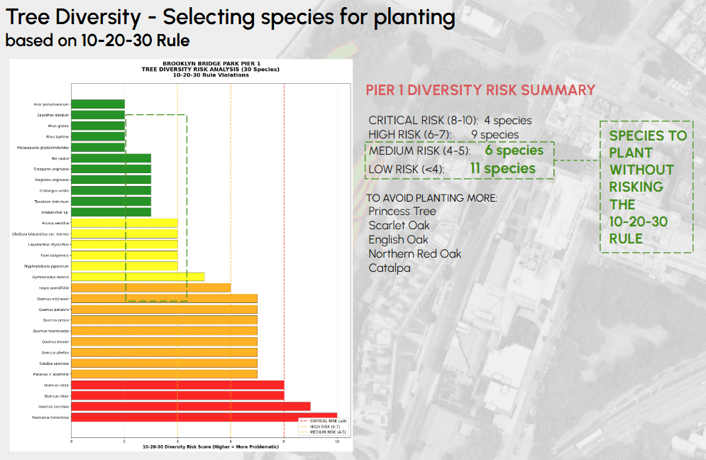
While increasing the number of trees – we think it is also extremely important to select which species the consider. The 10-20-30 rule, proposed by Frank Santamour, ensures urban forests remain resilient to pests and disease. It limits planting to no more than 10% of one species, 20% of one genus, and 30% of one family. By prioritizing medium- and low-risk species, we prevent monoculture vulnerability and increase ecological stability. These species should be distributed evenly across the site — particularly in replanting zones, pathways, and lawns — to create structural and genetic diversity.
Species selected under the 10-20-30 rule are evenly distributed across replanting zones, pathways, and lawns to ensure structural and genetic diversity. Biodiversity-rich species are clustered in low-disturbance edges within the Bridge view Lawn to form habitat nodes, while sensory and tactile trees are placed near playgrounds and seating areas to encourage safe interaction and ecological learning.
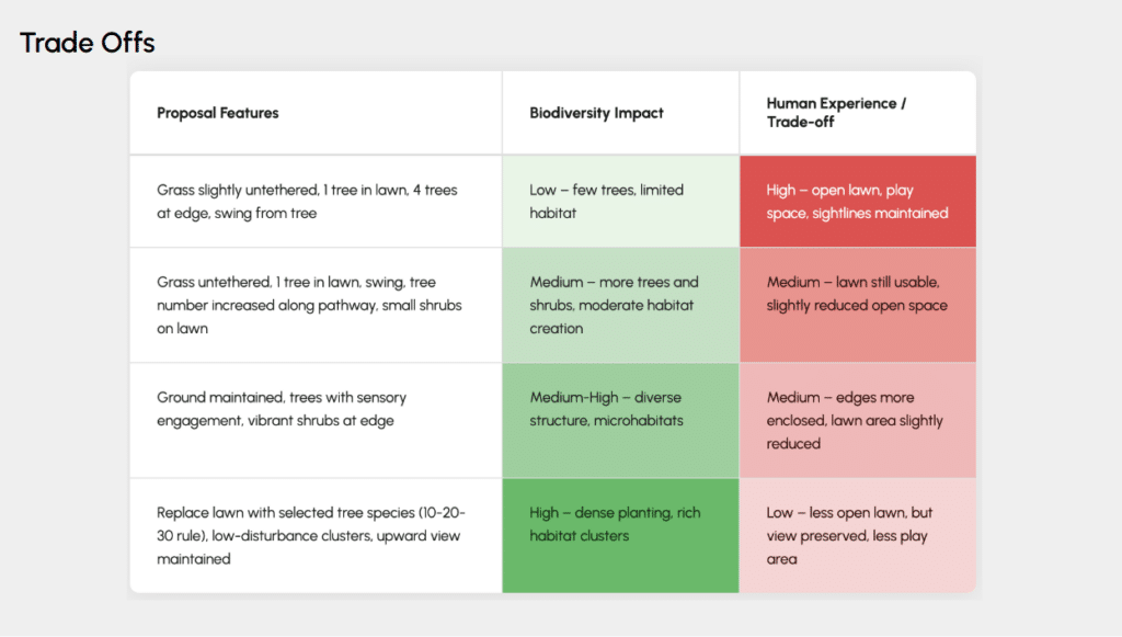
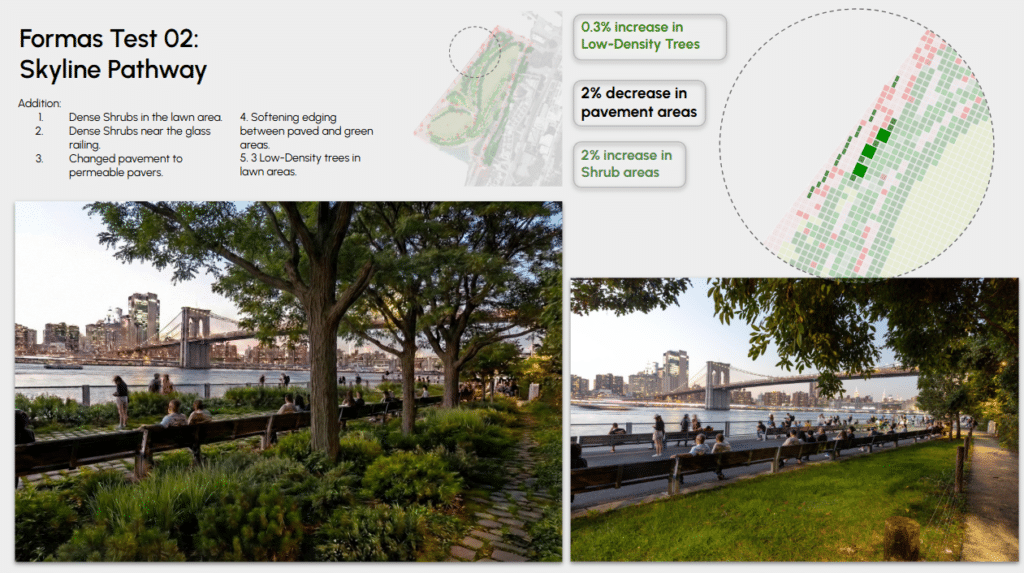
Conclusions – Overall, Pier 1 shows that while the park is successful as a lively public destination, its busiest areas leave limited space for habitat. The Formas tests suggested practical adjustments — breaking up large lawns, adding native planting along paths, and turning edges into small habitats — that allow biodiversity to increase without pushing people out. The key takeaway is that improving ecological value doesn’t require less activity, just smarter design so human use and nature can share the same space
