Mobility Hubs for Edge Cities to Reduce Car Demand
Ticket to Ride gamifies public transportation to reduce car trip demand with a single ticket for all rides at the mobility hub: the new heart of the conceptual Edge City.
Why the Edge City? The Edge City is a global suburban spatial condition constructed in the image of the car and facilitated by the demand for new types of space. Citizens of “satellites” often commute locally by car and to central cities along corridors of concentrated car demand. Our goal is to create an engaging hub that reduces car demand for a better climate, provides more space for community assets, and increases citizen leisure time.
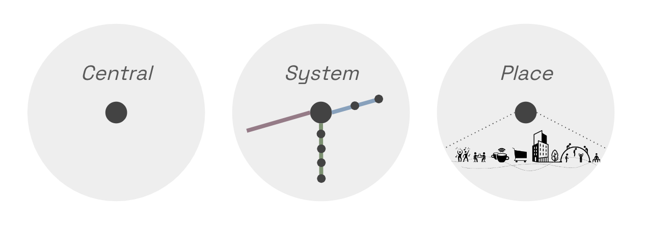
Why the Hub? The hub is the system for the future of collective transportation. For people to stop driving cars, alternatives must be offered that are:
- centralized, to maximize reach and minimize travel times,
- systematized, with the central hub servicing a shed of smaller hubs that service last-mile trips, and
- places, where people want to be and with demanded functions.
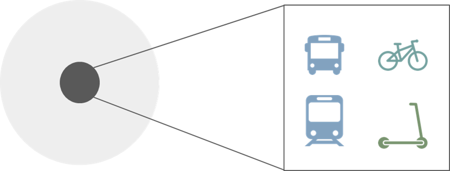
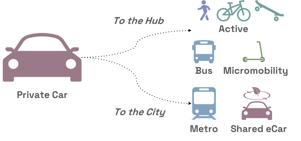
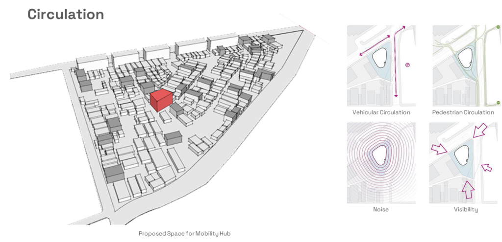
A mobility hub provides multiple modes of transportation in a centralized location
Who is it for?
The hub is for the stakeholders of car demanders of the Edge City. Car demanders and their passengers need To design these hubs effectively, it is crucial to construct detailed user profiles based on typical journeys, ensuring that the hubs cater to specific needs and enhance overall user experience. This post delves deep into the process of constructing user types and mapping their journeys to design targeted, efficient, and engaging mobility hubs.
To effectively cater to the diverse needs of an urban population, we first identify key user types typically found in urban environments. These include:
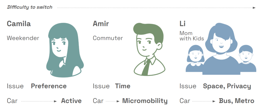
- The Weekender: Typically engaged in education, entry-level jobs, or remote work, the weekender that attends social events in the central city.
- The Typical Commuter: Working professionals who travel daily from suburbs to city centers.
- The Mom with Kids: Parents managing daily school runs, grocery shopping, and other errands.
The car-dependent users are typified by the weekender, whose day is modeled by a visit to the central city, the commuter, who It is expected to foster the car-dependent users that rely on private transport to commute.
What is it for?
To provide options to users so they can rely less on the private car and be motivated to shift to active and public modes of transport.
Where is it located?
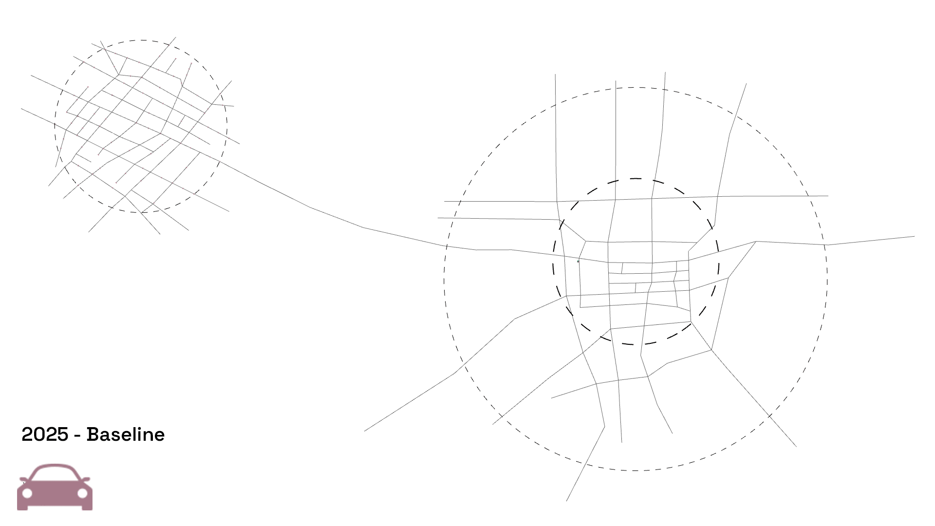
In the Edge City: a typololgy of urban conurbation within the Metropolitan Area of a Central City. It is a city that heavily relies on its connection to the Central City, as most of its inhabitants commute on a daily basis to work.
When will it take place?
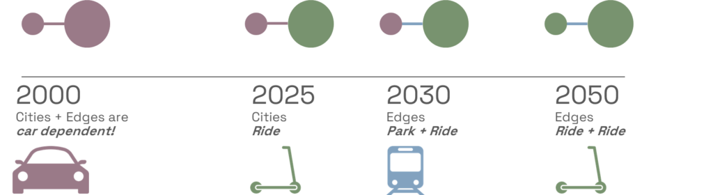
Is is expected to develop as a phased process that slowly adapts to the transition desire of its users. Cities and their edges were dependent on cars in the year 2000.
Why is it necessary?
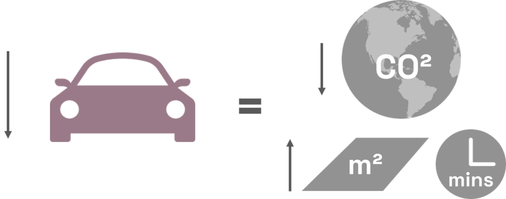
Because private cars have a huge impact on the production of CO2 and pollution emissions, they inefficiently occupy space that could be designated for flexibile community uses, and translate into a cumulative sum of time wasted in commuting.
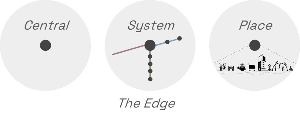
How does it work?
The hub must be:
- a centrality, accessible to the new destination for the inhabitants of the Edge City,
- a system, so it provides the intermodal and inter-scalar connections between all modes of transport, and
- a place, providing the comfort, services, and amenities that the future Edge City needs to become a destination.
Place
The 100 largest Edge Cities in the world share a homogeneous set of characteristics, as they are:
- Car-Dependent | Cities where more than 70% of the population relies on cars as their primary mode of transportation were categorized as car-dependent.
- Transit-Oriented | Cities where more than 35% of the population relies on public transit as their primary mode of transportation were categorized as transit-oriented.
- Suburban Satellite Cities | Cities falling within the range of 65-70% car dependency and 20-25% transit dependency were categorized as suburban satellite cities.
- Metropolitan Transit Hubs | Cities with significant metropolitan transit infrastructure, such as major transportation terminals or transit centers, were categorized as metropolitan transit hubs based on their prominence within the region.
Therefore, understood as a characterized typology, the Edge City constitutes itself as an urbanization that is very dependent on the Central City as a destination, usually connected by a metropolitan road infrastructure that, at least in the majority of cases, has low access to metropolitan scale public transport. Therefore its inhabitants rely on the use of private cars.
People and their Flows
Prototyping People
Each persona’s daily routes are mapped from home to multiple destinations including workplaces, schools, stores, and leisure spots. These journeys highlight high travel frequency areas that could benefit from targeted mobility hub placement.
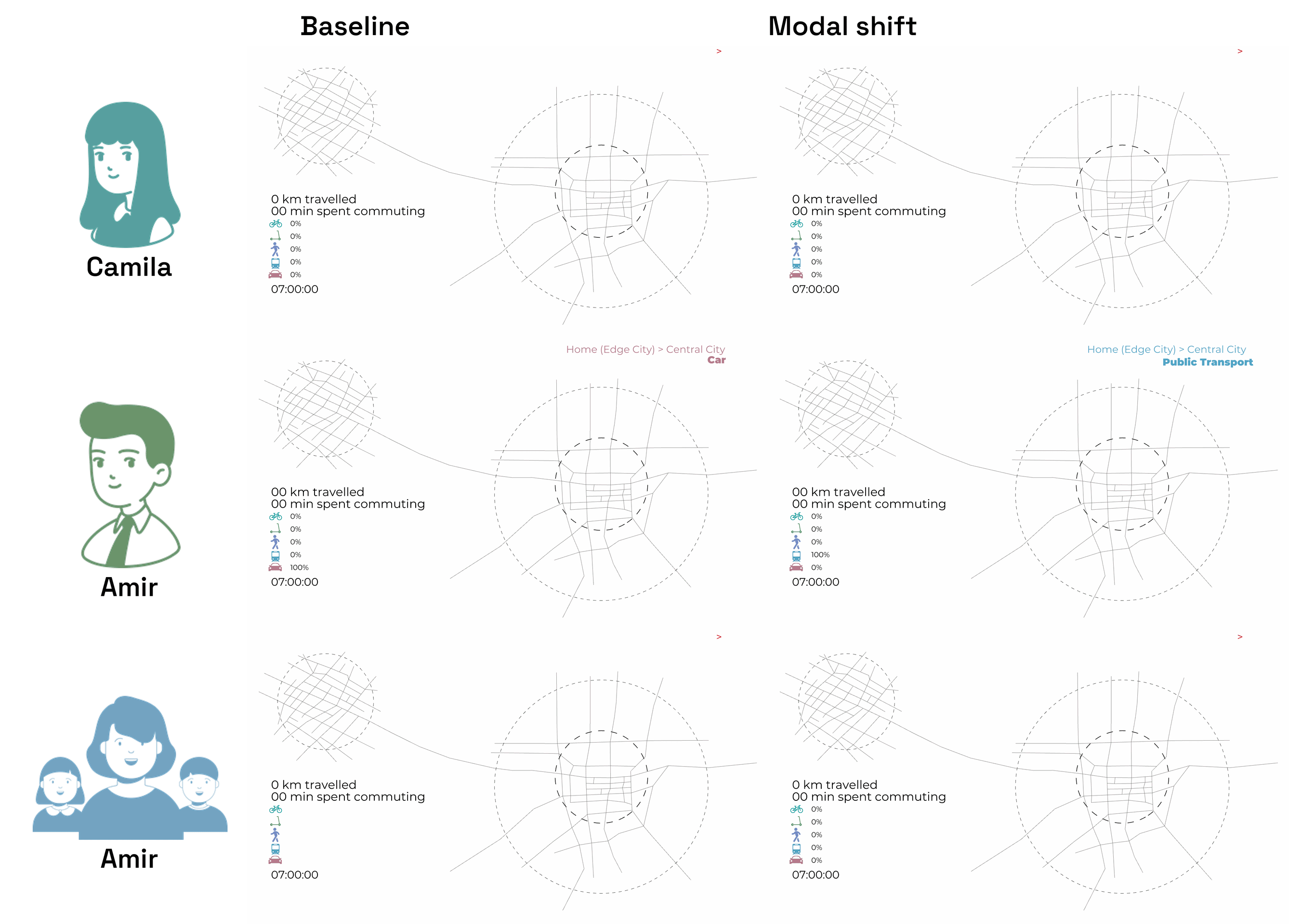
1. Camila – Living at Home, Staying in the City
- Current Mode: Uses her car extensively, even for short trips within the city.
- Proposed Mode: Shifts predominantly to Public Transport and retains biking for leisure and short commutes.
- Journey Analysis:
- Using public transport for her daily commute and to social destinations like restaurants and gyms can be made appealing through enhanced service frequencies and last-mile connectivity.
- Biking remains her mode for leisure activities, providing flexibility and enjoyment.
- Drivers of the Switch:
- Enhanced Last-Mile Connectivity: Introduces e-bike sharing stations at public transport hubs to facilitate easy access to final destinations.
- Lifestyle Campaigns: Promotes the health and environmental benefits of biking through city-sponsored programs and incentives.
- Subsidized Public Transport for Young Adults: Offers discounted passes to encourage the adoption among the younger demographic who may have less disposable income.
2. Amir – The Suburban Commuter

- Current Mode: Predominantly uses his car for commuting and moving around the city.
- Proposed Mode: Shifts towards Public Transport and Micro Mobility.
- Journey Analysis:
- Amir’s typical day begins with a car ride from his suburban home to the Central City, which is heavily congested during peak hours. To alleviate this, he could utilize public transport, benefiting from dedicated lanes and reduced travel times.
- For shorter inner-city trips currently taken by car (e.g., from restaurants to client meetings), micro-mobility options such as e-scooters could be faster and avoid parking issues, making them a preferable option during busy hours.
- Walking remains unchanged for short distances like between a restaurant and an art gallery, promoting health and environmental benefits.
- Drivers of the switch:
- Ticket to Ride: The universal mobility pass provides access to all public and micro-mobility services at a flat rate, encouraging the use of various transport modes without the hassle of multiple tickets or apps.
- Congestion Charges: Implementing charges for car usage in high-traffic zones during peak hours can discourage car use and promote public transport.
- Priority Lanes for Public Transport and Micro Mobility: Ensures faster travel times during peak hours, making these options more attractive than driving.
3. Li – Mom with Kids

- Current Mode: Relies on her car for flexibility around school runs and errands.
- Proposed Mode: Incorporates more Public Transport for commuting to the city, while still using cars for local errands. Shifts to bikes for certain local trips.
- Journey Analysis:
- For school drop-offs, the use of a car might still be necessary for flexibility. However, her trips into the city could shift to public transport, where reliability and speed are enhanced through dedicated services.
- The transition to biking for nearby errands like visiting hardware stores not only promotes physical activity but also reduces local traffic congestion.
- Drivers of the switch:
- School Zone Parking Restrictions: Encourages the use of walking, biking, or carpooling for school runs.
- Improved Public Transport Services During School Hours: Offers reliable and frequent services that align with school timings, facilitating easier commuting for parents.
- Infrastructure Improvements: Secure bike lanes and pedestrian zones near schools and local centers encourage walking and cycling.
Prototyping Flows
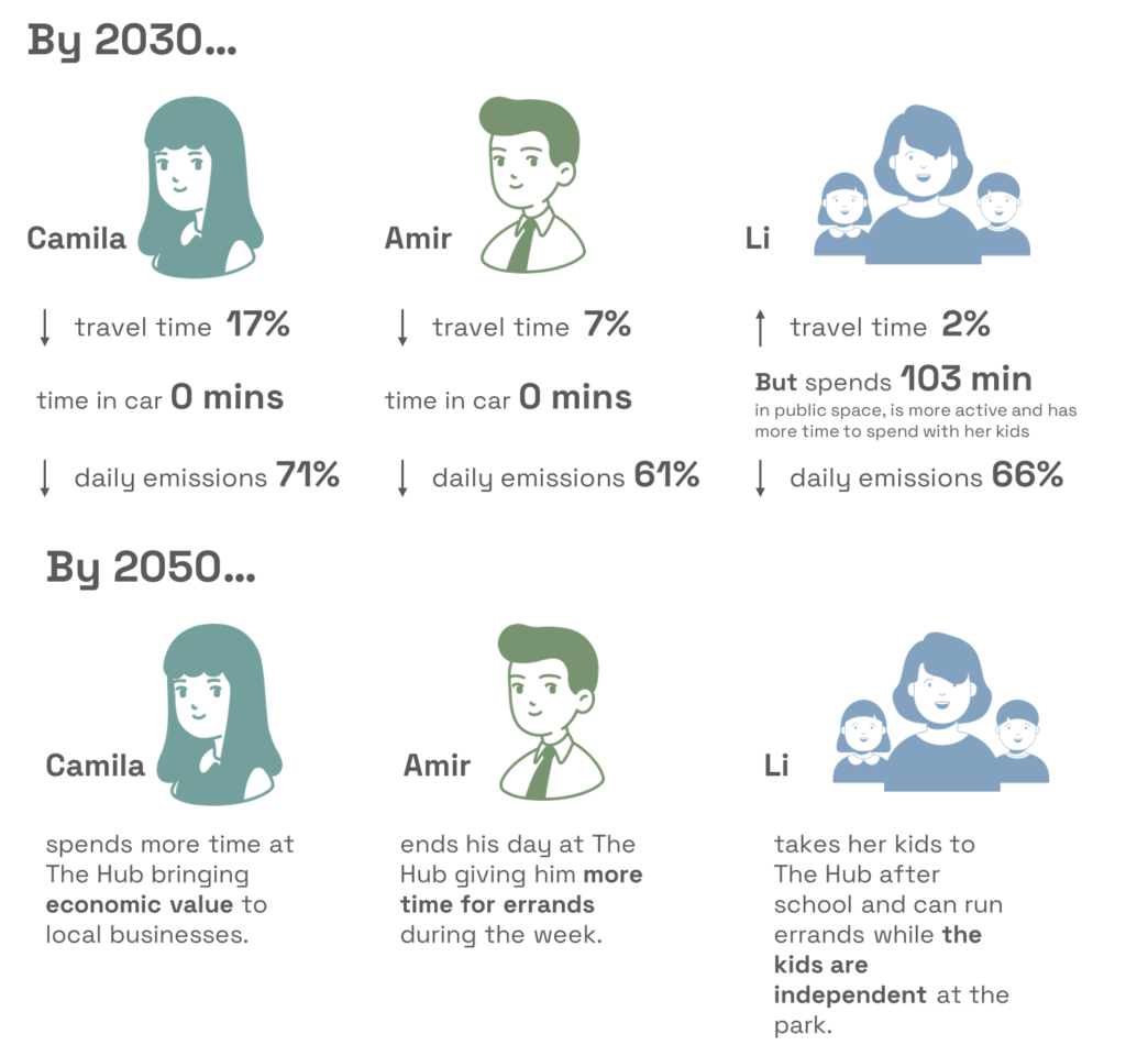
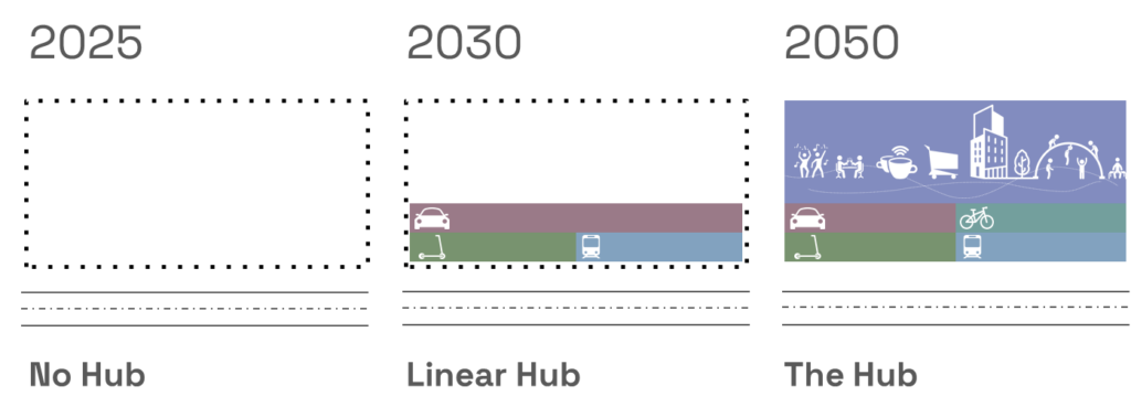
A generalized approach to understanding the mobility dynamics of an Edge City demonstrates the pendular patterns between its inhabitants commuting daily to the Central City as a destination. Within the framework of the three phases, it is expected that the volume of metropolitan trips in private scale gradually shift to public modes by 2030. In the longer term, it is expected not only for the volume of these long-distance trips to migrate entirely to public transport, but also the local trips within the Edge City can stop depending on the private car and migrate active, non-motorized modes or micro mobility modes.
Just as the impact of The Hub materializes in macroscopic approach, it is important to understand how it impacts the people itself. This is how, by forecasting a differential shift from our personas, it is possible to predict an important variation in their daily individual modal shift. First of all, Camila, with a higher probability of mode shift, can transform her daily patterns by entirely replacing the car-based trips to the Central City with public transport. Amir, with an intermediate position, could even replace all of his car-based trips and take advantage of public transport and micro-mobility modes for short distance trips. And finally, even Li, with a greater difficulty to migrate, could take advantage of active modes to replace the car in her local trips and therefore enjoy more time in the public space with ehr kids.
As explained before, the main objective of The Hub is to provide choices to users. An integral approach to this strategy can also encompass means for data collection, with the examples stated below:
- Micromobility (E-Scooters, E-Bikes): Utilize efficiency and adoption data from EIT InnoEnergy by McKinsey, focusing on micromobility’s impact on urban mobility, costs, and usage patterns.
- Cars: Implement assumptions based on Travel Time’s model for car usage, focusing on average travel times, fuel efficiency, and congestion impacts.
- Bicycles: Use data from Bike Portland to model bicycle travel times and usage, including factors like city bike-friendliness and cycling infrastructure.
- Buses: Draw on STRIDE University of Florida’s research on Mobility on Demand for bus travel efficiency, integration with other transport modes, and passenger load factors.
User Journey Mapping: Map typical daily routes for different user personas using an integrated approach that combines all available data on various transport modes. This will highlight primary and secondary transit points, usage peaks, and potential bottlenecks.
Modality Analysis: Analyze each transport mode’s effectiveness using the respective source’s insights. Assess parameters such as speed, cost, environmental impact, and user preference to identify potential for shifts toward more sustainable and efficient options.
Simulation and Optimization: Simulate transitions from traditional to MOD systems using basic analytical models. Explore scenarios like replacing solo car trips with micromobility or enhancing bus routes with efficient on-demand transit solutions. Consider the introduction of park-and-ride facilities as per the Miami 2045 Long Range Transportation Plan.
Policy and Design Integration: Suggest urban design changes and policy adaptations that facilitate MOD. This might include infrastructure improvements, zoning adjustments, and the deployment of smart technology for real-time data integration across modes.
Assessment and Adjustment: Monitor the outcomes using key performance indicators such as reduction in average travel times, user uptake of new MOD options, and environmental impact metrics. The model should be adjusted to accommodate changes in technologies and based on user feedback.
Design
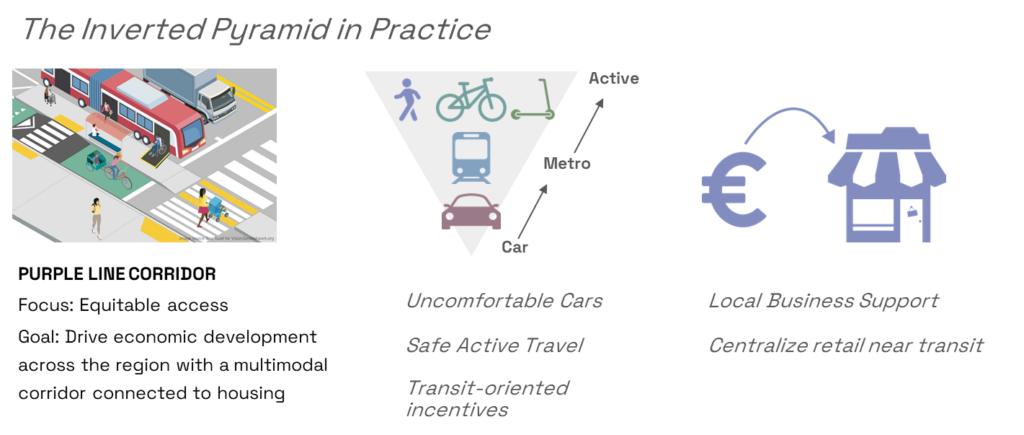
The vision for the Ticket to Ride design was to invert the hierarchical pyramid of habitual private vehicular use for single trips by providing efficient, affordable alternatives. From a model of ‘Park and Ride’ to ‘Ride and Ride’, the new mobility hub would be central destination, with mixed-use public spaces, recreational opportunities and most importantly, integrated system of inter-modality. Thus, the new hub would seamlessly connect communities to amenities and provide multiple carbon-neutral alternatives to car-based travel. By evaluating existing case studies, the method of inverting the pyramid would require improved transit networks, bike paths, active outdoor/indoor facilities and proximity to local businesses, which would to support the hub as an attractive node to meet within the satellite city.
The Hub should be a means for interconnection of trips, facilitating higher levels of shared mobility use by removing the friction of movement in an urban transit hub. But it should also be a desired destinations for inhabitants of the satellite city to foster activities within the Edge City even to the point to replace trips that require going into the Central City nowadays. As a programmatic solution, the Hub should follow the design objectives of Sustainability and Accessibility. It should foster the use of Green Energy, incorporating renewable energy sources, such as solar panels, to power the hub. The water runoff from the structure can be recycled for building functionality. This enriches the proposal to enhance the emissions mitigation, not only by the reduction in car trips but by the performance of the mobility hub as a building itself. Aditionally, The Hub should ensure the principle of Universal Design, making the hub is accessible to all, including people with disabilities.
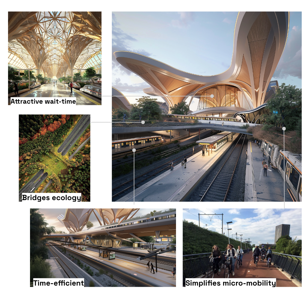
By achieving these principles, the Hub as an architectural piece must allow the free movement through space, serving as an easy conneciton both in the metropolitan and in the local scale for active modes. The ease of circulation through The Hub is fundamental so it does not fragment the urban structure of the satellite city. More than architectural piece it shoudl be a vital urban node.
Within the phased strategy, the Hub can gradually transform the usage of space by hosting a space for every mode, that transitions to prioritze spaces for people, activities and active modes of transport.
In detail this means that at each stage, the community is expected to become less dependent on cars, therefore parkings and other car-dedicated spaces can start hosting activities, amenities or public spaces.

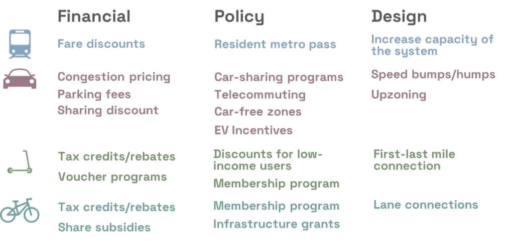
Incentives
In practice, people need to be incentivized to replace their car usage for public and active modes. This needs an integral strategy of incentives that highlights the utiliity of not using the car. It can include a variety of incentives from financial, policy or design strategies, focusing specificaly on each type of demand segment and transport mode.
Impact
The shift in transportation mode from private vehicles to public and non-motorized forms through the strategic placement of mobility hubs, supplemented by robust policy frameworks, design innovations, and financial incentives, can significantly transform urban mobility landscapes. These changes aim not only to reduce congestion and pollution but also to enhance urban livability and accessibility, aligning with broader sustainability goals. Just as the effects can be generalized for the benefit of the entire city, they are evident even for our personas, Camila, Amir and Li, as they might reduce their travel times, their CO2 emissions and have more time to spend in the public space, and spend less time in commuting.