

This thesis investigates how the semantic content of urban climate policy can be computationally coupled with high-resolution geospatial data to anticipate the climate consequences those policies set in motion. The work is situated in the metropolitan area of Barcelona, and the central proposition is that policy text far from being inert prescriptive language is itself an actionable dataset, provided we have a model capable of reading it.
Context
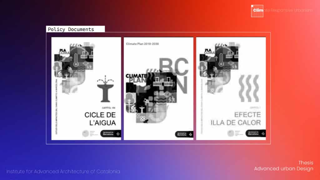
Contextualized in the metropolitan area of Barcelona, explores extreme climate conditions in dense urban environments and reading through policies and planning proposals. Specifically, the aim is to map how the city responds to these climate policies.
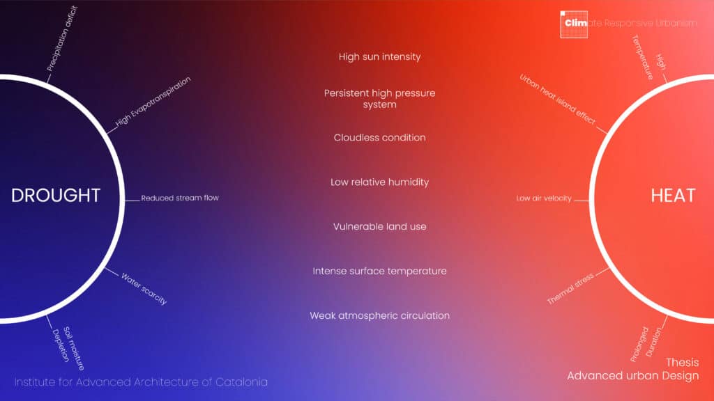
Drought and heat are interrelated phenomena. They share antecedents in surface temperature, vegetative cover and impermeable surface fraction. Their downstream impacts, however, diverge: drought operates through evapotranspiration deficit and water-supply contraction, heat operates through elevated land surface temperature, reduced radiative cooling, and degraded thermal comfort. A robust policy-impact framework must disentangle these two channels rather than collapse them into a single climate-risk scalar. This disentanglement pursued through the SHAP value decomposition described later in this article is a recurring methodological concern throughout the pipeline.
Problem of reading policies
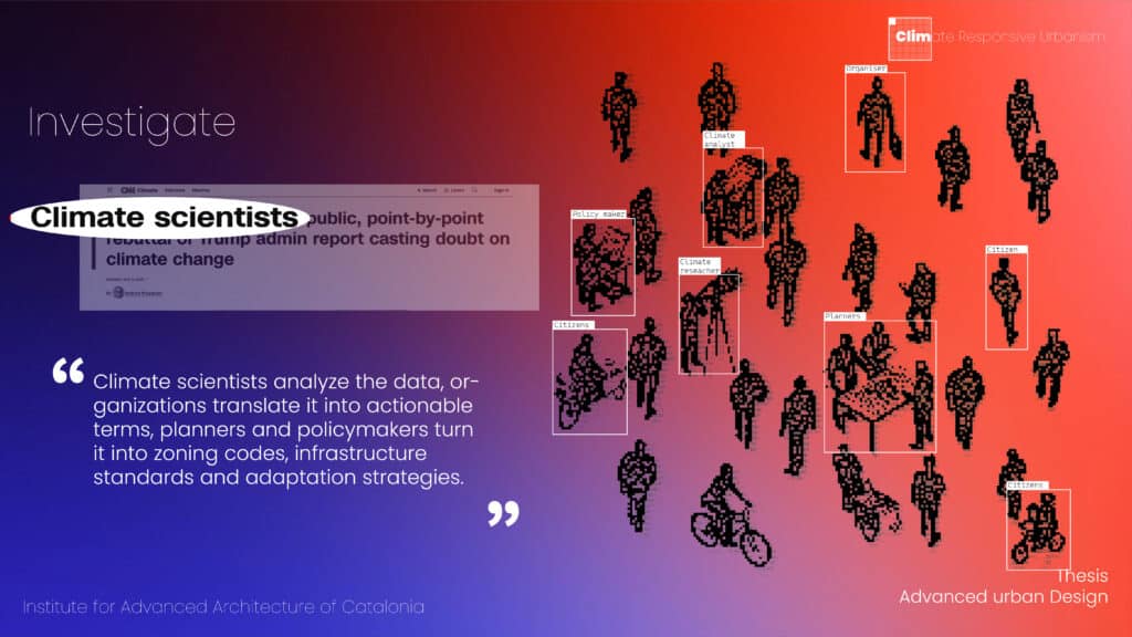
A well-documented gap separates climate science from urban planning practice. Climate scientists generate models, scenarios and risk assessments at progressively higher spatial and temporal resolution. Planners and policymakers must translate this knowledge into zoning codes, infrastructural standards, building bylaws and adaptation strategies. That transposition is at present, almost entirely manual: a planner reads the science, consults the policy archive and exercises judgment. The judgment is necessary, but it is neither systematic, reproducible, nor scalable to the volume of documentation a contemporary metropolitan administration produces. The work presented here is an attempt to construct the computational scaffolding for that translational layer not to displace human judgment but to render it tractable at the scale of an entire policy corpus.
Research Question
The research question, stated formally, is the following: how can we computationally bridge and simulate the impact of policy language and geospatial data with respect to the climate crisis, using semantic artificial intelligence and a digital twin architecture? The question is deliberately framed at the intersection of three research traditions natural language processing, urban climate science and computational urbanism, none of which, in isolation, can answer it. The methodological contribution of the thesis lies in how these three are made to cohere within a single inferential pipeline.
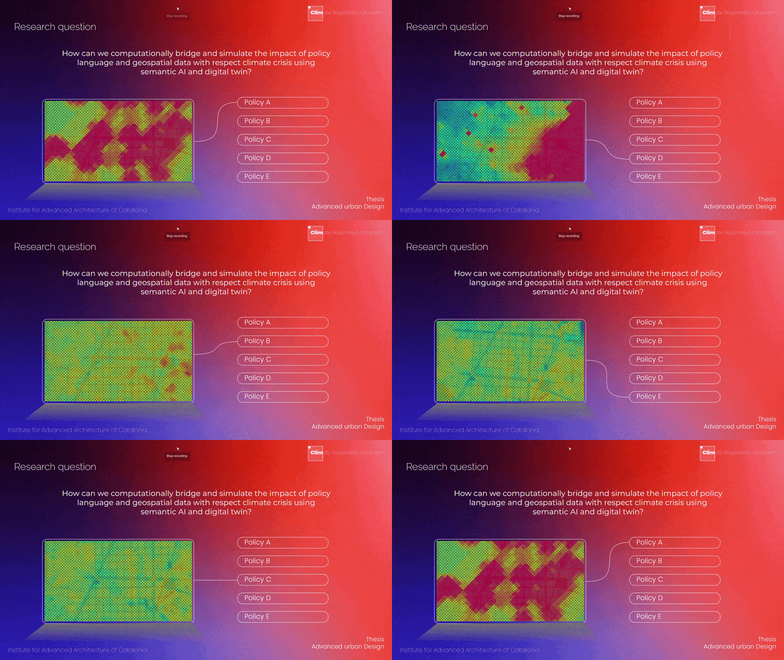
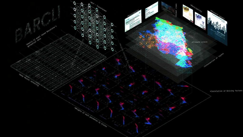
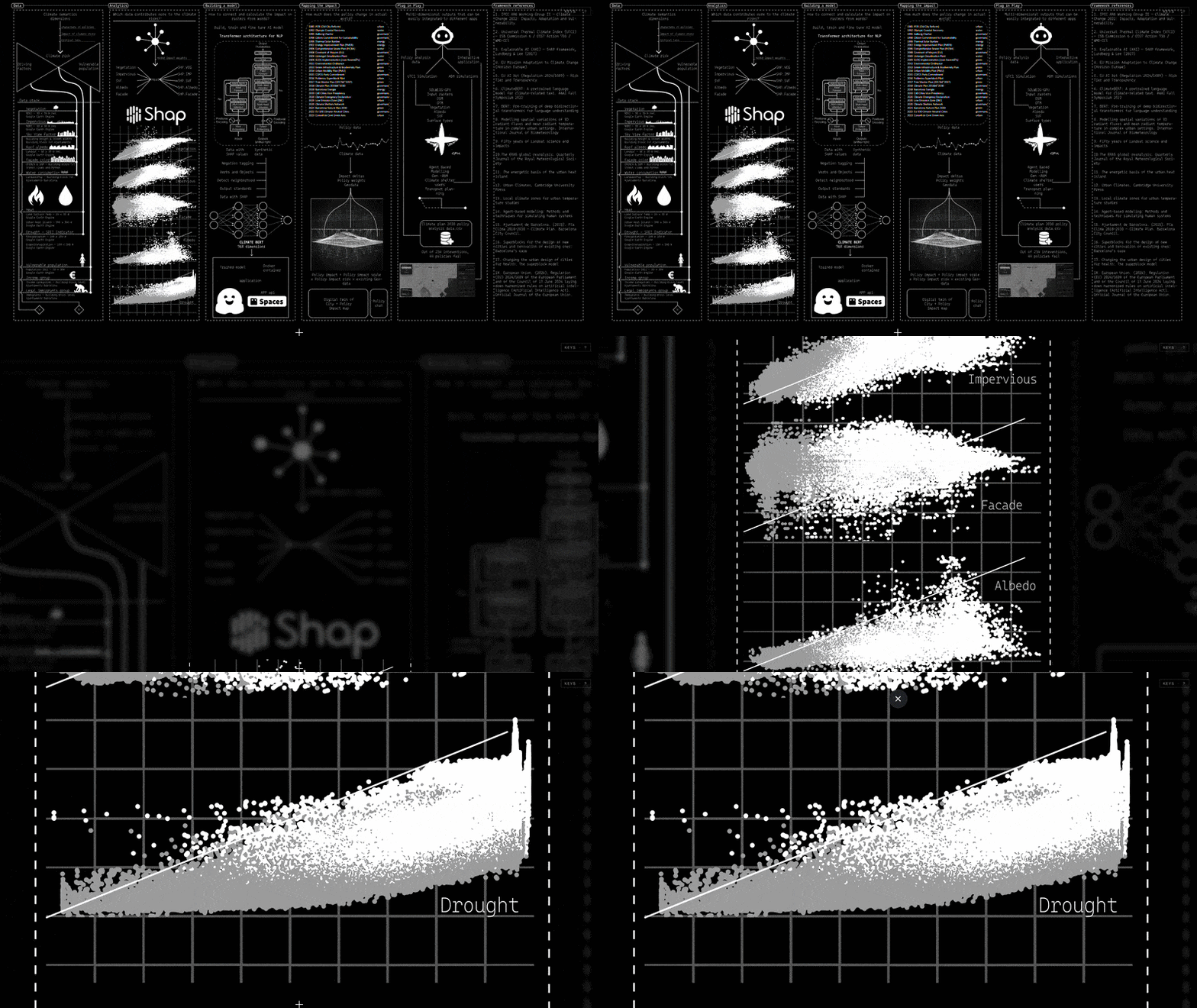
Here is a diagram showing the entire workflow in a nutshell through an abstract illustration.
Framework
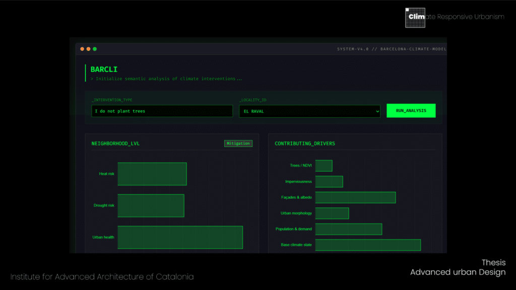
The work organises into five operational phases. First, semantic understanding: deploying a domain-adapted transformer to extract intent, directional polarity, and impact vectors from policy sentences. Second, model construction: building a human-centric impact-assessment architecture that couples semantic outputs to spatial drivers through a SHAP-weighted neural network. Third, impact mapping: spatialising the predicted consequences onto Barcelona’s neighbourhood-level fabric, producing maps that render the differential exposure of urban districts to policy-induced perturbations. Fourth, the deployment of a plug-and-play tool provisionally named BARCLI that permits researchers, planners, and policymakers to interrogate the model without requiring computational expertise of their own.
- Data stack and Analyze
- Build an AI model
- Mapping the impact on real time data
- Plug – in Play
Data stack
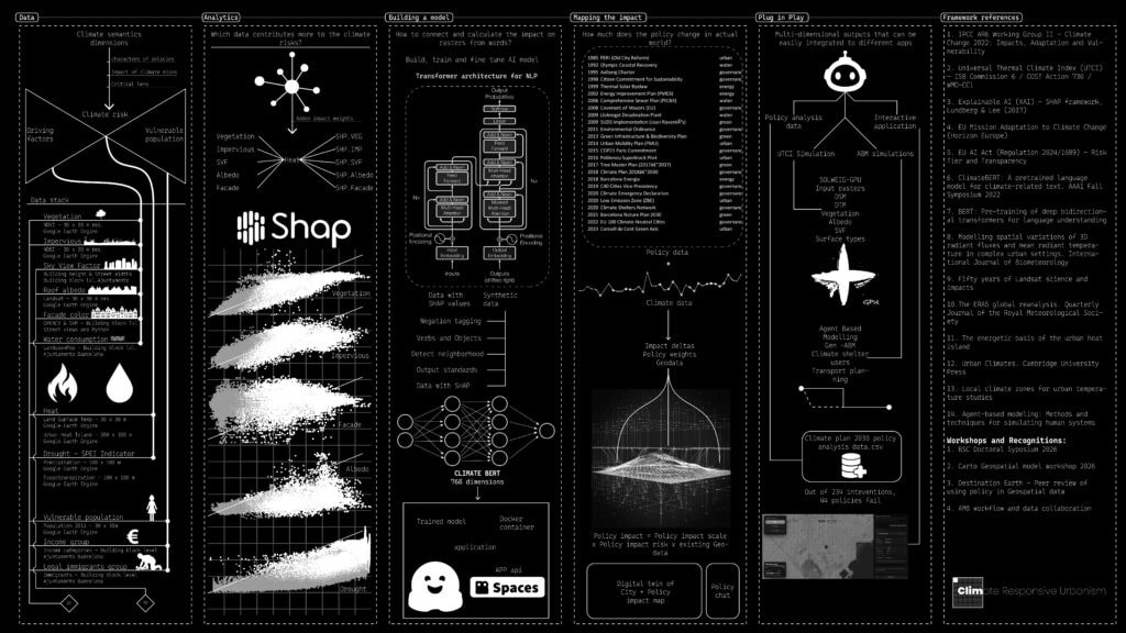
The empirical foundation of the work aggregates three categories of input. The first is the biophysical layer: Land Surface Temperature derived from LANDSAT imagery at thirty-metre resolution; the Standardised Precipitation-Evapotranspiration Index (SPEI) as the operational drought indicator; NDVI and NDBI for vegetative cover and built-up fraction respectively; a digital surface model and a digital elevation model at two-metre resolution; and albedo derived from spectral reflectance. The second is the synthesised climate-risk channel that aggregates these into three operational indicators heat, drought, and urban health. The third is a socio-demographic layer overlaying population density, age distribution, and vulnerability profiling per neighbourhood unit, drawing on Ajuntament census data and the Catalan health ministry’s vulnerability registers.
Computer Vision – Heat score for facades of Barcelona
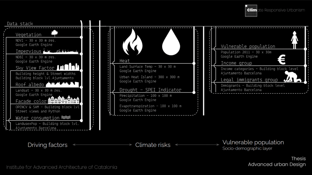
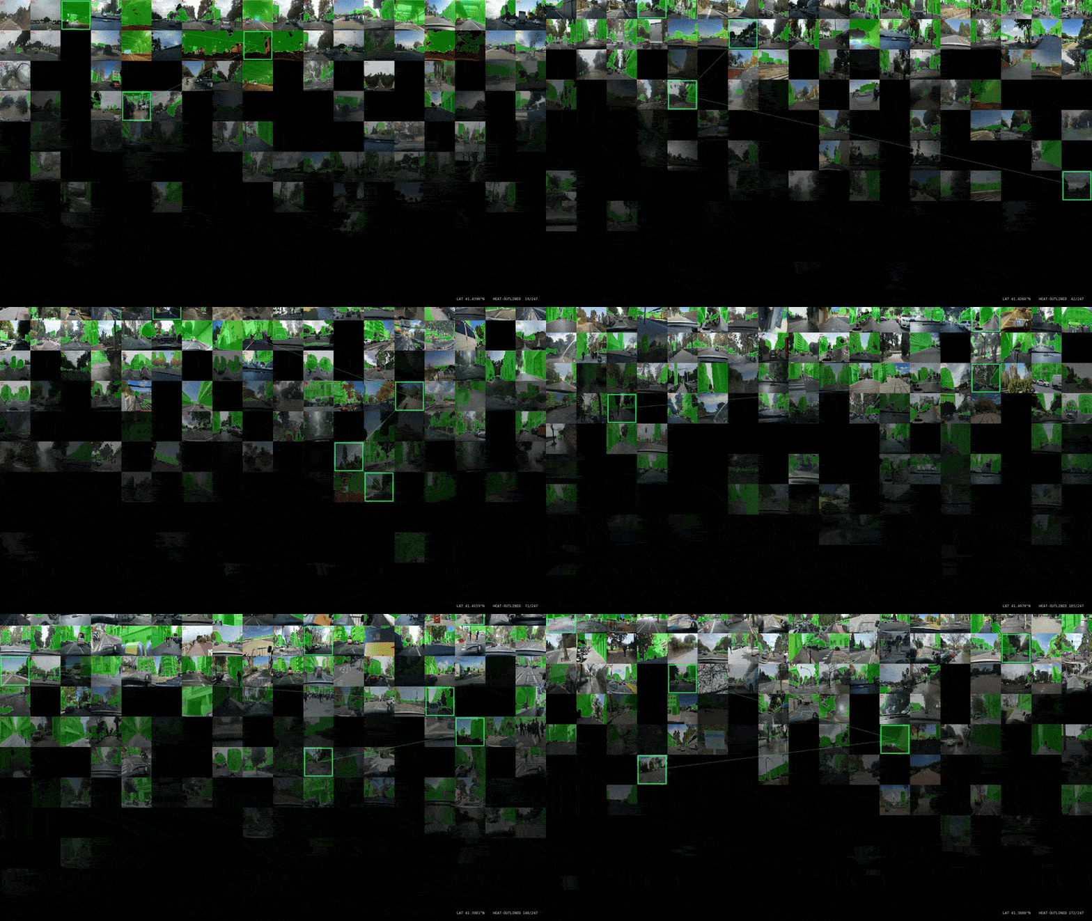
One methodological contribution within the data stack deserves explicit attention. Façade thermal absorptance the rate at which a building surface absorbs incident solar radiation is a critical parameter in urban heat island modelling, yet is rarely captured at the granularity of the individual building in conventional urban climate datasets. To address this lacuna, we assembled a corpus of approximately five thousand street-view images covering the metropolitan area of Barcelona, applied white-balance normalization to control for capture-condition variance, segmented the building façades by visual priority, and used unsupervised pixel-clustering on the segmented regions to extract the dominant chromatic value per façade. That dominant value was then mapped onto a heat-score axis through a luminance-and spectral-reflectance transformation, producing a photometrically grounded heat-vulnerability layer at the scale of the individual building. The resulting layer is, to the best of our knowledge, the first façade-level thermal-absorptance dataset for the metropolitan area at this resolution.
SHAP – Dependency weights
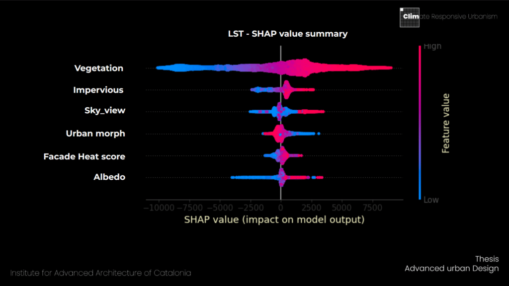
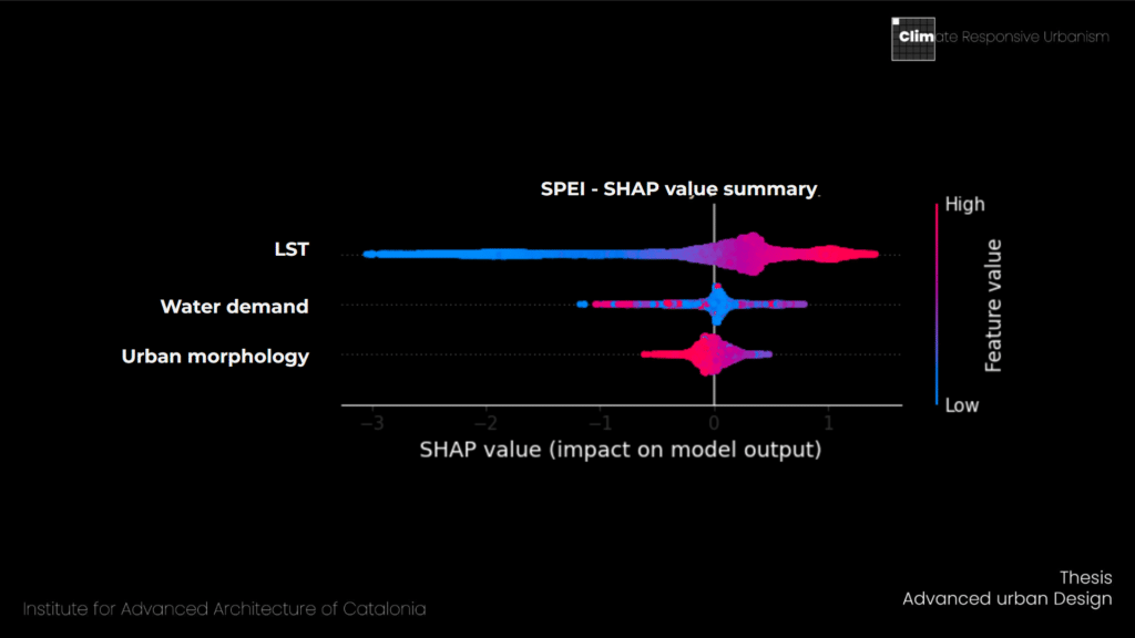
A model intended for policy-facing applications cannot operate as a black box. The decisions a tool of this kind informs what to build, what to prohibit, where to invest demand a defensible account of why the model has produced the prediction it has produced. We adopt the SHAP framework – Shapley Additive Explanations as the interpretability substrate. SHAP assigns to every input feature a value quantifying how much that feature pushes the model’s prediction above or below the baseline, with theoretical grounding in cooperative game theory and provable consistency, local accuracy, and missingness properties. This places the analytical layer of the thesis within the interpretable machine-learning tradition rather than within the black-box paradigm a deliberate methodological commitment given the public-policy applications to which the tool is addressed.
The SHAP decomposition for Land Surface Temperature, computed across the six driving factors of vegetation, imperviousness, façade heat score, sky-view factor, albedo, and urban morphology, exhibits the asymmetry one expects from an empirically well-posed model: imperviousness and façade heat dominate the warming tail of the distribution, vegetation and albedo dominate the cooling tail. The decomposition for the drought channel, SPEI, identifies Land Surface Temperature itself, water demand, and urban morphology as the three principal drivers: a result that empirically validates the coupling between thermal and hydrological stressors. Thermal load increases evapotranspiration, which propagates into hydrological deficit; the two channels are not independent, and a policy intervention targeting one will necessarily perturb the other. The decomposition makes this coupling computationally explicit.
Building a Semantic AI model
The semantic component of the pipeline is built around ClimateBERT, a domain-adapted transformer purpose-built for climate-related text. ClimateBERT inherits the RoBERTa and DistilRoBERTa architectural lineage, part of the broader BERT family and is pre-trained on over two million paragraphs of climate-specific corpora drawn from scientific publications, corporate disclosures, ESG reports, and policy documents. Crucially, its tokenizer is augmented with specialised climate and finance vocabulary, terms such as CO₂ and CH₄ receive proper representational treatment rather than being fragmented into uninformative subword tokens. The model emits seven-hundred-and-sixty-eight-dimensional embeddings that constitute the semantic feature substrate on which the downstream classifier operates.
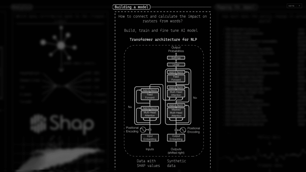
An earlier attempt to deploy a general-purpose transformer without domain adaptation failed conclusively: the embeddings exhibited insufficient discrimination between climate-positive and climate-negative policy formulations, and downstream classification accuracy collapsed below acceptable thresholds. The transition to a domain-adapted model was not an aesthetic refinement but a methodological necessity that the data made unavoidable an observation we record explicitly because the negative result is itself a finding worth reporting in this research space, where the choice between general-purpose and domain-adapted language models is frequently made without empirical justification.

Training and Fine Tune
Policy language is rhetorically dense and semantically tricky. Several linguistic preprocessing operations were necessary to render it tractable. A negation-tagging module identifies function negators words such as not, no, never, neither, without and semantic negators such as absence, lack, removal, loss, which can invert the polarity of an apparently positive intervention. A verb-and-object parser disambiguates structures such as cutting trees to increase viewpoints, isolating the action verb from the affected object so that the direction of impact can be properly inferred. A neighbourhood-detection module identifies geo-entities references to specific Barcelona districts such as El Raval, Gràcia, Poblenou, les Corts, el Gòtic and routes the impact vector to the correct spatial unit. A quantitative-direction module encodes whether the intervention increases or decreases the targeted parameter. The output is a structured tuple per sentence: direction (mitigation or aggravation), three-dimensional impact vector across heat, drought, and urban health, and intervention type.
The training corpus comprises thirty thousand sentences, each parsed into the structured schema described above. Each record carries the original sentence, the detected neighbourhood, the year, the binary direction, the three-channel impact vector, and the intervention type. This is the per-sentence ground truth against which the model was supervised, and the per-sentence inference output the model produces. The schema is deliberately simple five fields per record but its analytical power emerges from the volume and the granularity at which it is applied. A document of one hundred and sixty-four pages, decomposed sentence by sentence, yields a structured dataset that supports queries no human reading could practically execute.
Tagging and Semantic logics
Synthetic sentences
Negation tagging:
FUNCTION_NEGATORS = {‘not’, ‘no’, “n’t”, ‘never’, ‘neither’, ‘nor’, ‘without’}
SEMANTIC_NEGATORS = {‘absence’, ‘lack’, ‘removal’, ‘loss’}
Verb and objects parsing:
“Cutting down trees to increase more view points for visitors”
Views, visitors – object, cutting trees – verb
Detect neighborhood:
detect_neighborhoods:
“We need more trees in Gracia”
“El Raval has high urban heat”
Quantities:
verbs:
‘Increase’,’add’,’expand’,’install’,’instal’
‘reduce’,’remove’,’cut’,’decrease’,’eliminate’,’clear’,’limit’,
Direction and impact mask:
direction=1 | impact=[-0.45, -0.02, -0.76] | sentence=blocks with car mobilization in horta
direction=0 | impact=[0.0, 0.13, 0.78] | sentence=the city is trying HARM_reducing HARM_asphalt HARM_surfaces around vila de gràci
[
{
“sentence”: “no cycling infrastructure planned for the area along transit corridors”,
“neighborhood”: “el Gòtic”,
“year”: 2022,
“direction”: 1,
“impact”: [
-0.33,
-0.15,
-0.64
Mapping the Impact
The semantic outputs of the inference layer are, in themselves, structured data; they become urban knowledge only when reflected back onto the geographical substrate from which the policy is meant to act. The mapping operation proceeds as follows. The Land Surface Temperature baseline, derived from LANDSAT thirty-metre imagery, is treated as the reference raster. Each policy intervention, parsed into its semantic tuple, is evaluated as a perturbation applied to this raster substrate, modulated by the SHAP-weighted contribution of each driver and by the socio-demographic vulnerability profile of the affected neighbourhood. The output is a redrawn raster representing the predicted post-intervention state of the urban thermal field, accompanied by the equivalent SPEI redraw for the drought channel.

Policy interventions and climate trajectories are not synchronous. Policy effects propagate with measurable lag through the climate signal, a lag the model is designed to estimate explicitly rather than ignore. The warming-stripe representation of Barcelona’s summer climatology between 1987 and 2025 renders the trajectory unambiguously: the post-2010 period is characterized by a dense clustering of positive thermal anomalies and negative SPEI excursions, the compound signature of the Mediterranean climate emergency. Against this empirical backdrop, the three-year policy-impact window is the methodological convention adopted to align textual interventions with their measurable climate consequences. It is short enough to remain attributable, long enough to permit propagation through the system.

LST data sources: * As per Ajuntament de Barcelona
SPEI indicators: * As per AEMET data source
The composite policy-impact metric is defined formally as the product of three terms: the impact scale derived from the semantic inference, the impact risk drawn from the SHAP-weighted driver decomposition, and the existing geodata baseline against which the perturbation is applied. The multiplicative form is deliberate. A policy with strong textual intent but weak risk coupling, or strong risk coupling but minor textual signal, produces only a modest aggregate impact. The structure forces all three components semantic, biophysical, and contextual to be jointly present for an intervention to register significantly in the impact field.

Plug in Play
The model produces multi-dimensional outputs that, by design, integrate into heterogeneous downstream applications. Policy analysts can ingest the structured data layer directly; urban-climate researchers can couple the model with the Universal Thermal Climate Index micro-climate simulation, using outputs such as mean radiant temperature, shadow geometry, and UTCI itself; transport planners can chain it into agent-based mobility models that simulate pedestrian heat exposure under shifting thermal regimes. The plug-and-play characterisation is not a marketing claim it is an engineering consequence of having defined the output schema with sufficient rigour to be consumed by independent toolchains, and of having committed to an open, documented data interchange format throughout the pipeline.
The deployment surface is conceived as a triple-display configuration: the BARCLI conversational interface, where a user can query the policy corpus in natural language; the BARCLI atlas, a deep-zoom interactive map that permits spatial exploration of the impact fields; and the interactive parametric model, where a stakeholder can adjust thresholds, weights, and scenarios in real time. The triple-display configuration permits a stakeholder to read text, examine geography, and adjust parameters in parallel a configuration intended to mirror the working practice of an urban planner rather than that of a data scientist.

Addressing Limitations
Three limitations frame the immediate research agenda. First, the scale of impact and the impact-calculation formulation are products of model assumptions and SHAP weightings that warrant further sensitivity analysis; the multiplicative composite metric introduced earlier is one of several admissible aggregation rules, and the comparative analysis of those alternatives is an outstanding methodological task. Second, while the training corpus comprises thirty thousand sentences, a portion of this corpus is synthetic generated through controlled augmentation to address under-represented intervention categories and the dependence on synthetic augmentation introduces a potential distributional bias that ground-truth validation against held-out municipal corpora must address. Third, the geospatial datasets, although the best presently available, exhibit known resolution and temporal-frequency limitations, particularly for the socio-demographic vulnerability layer, which is updated at census intervals rather than continuously.
These limitations are not concessions but commitments. Each frames a strand of immediate further work: SHAP-attribution validation at the token level for the contrarian classifications described in section 9; expanded corpus collection through partnerships with municipal water and mobility agencies; and integration with continuously updated administrative datasets such as Aigües de Barcelona’s water-consumption telemetry and the Catalan Health Agency’s vulnerability registers. The thesis does not claim to have closed the translational gap between policy and climate; it claims to have demonstrated that the gap is computationally bridgeable at the scale of an entire metropolitan policy corpus, and to have built the first operational instrument that does so.

Reflection
The thesis began with an observation about reading. Urban climate policy is, before it is anything else, a body of writing and the question of whether that writing can be read computationally, at scale, with semantic fidelity, and with explicit coupling to the physical surfaces it is meant to govern, is no longer a hypothetical question. The work presented here demonstrates that it can. It also demonstrates that doing so reveals dimensions of public policy that neither textual analysis nor geospatial modelling, undertaken in isolation, can surface and that the dimensions surfaced are not curiosities of method but substantive findings about how policy and climate interact at the scale of an entire city.
The longer-term ambition of the BARCLI tool is to render the routine work of urban climate governance the reading of plans, the interrogation of measures, the simulation of consequences tractable for the institutions and practitioners who must perform it. Whether the tool succeeds in that ambition is a question only sustained engagement with municipal, metropolitan, and research partners can answer. The framework, the corpus, the model, and the deployment surface are in place. What remains is the work of putting them to use.
Acknowledgement
This work was developed in the Master in Advanced Architecture at the Institute for Advanced Architecture of Catalonia (IAAC), Barcelona, under the supervision of Dr Mathilde Marengo (Director, MAA), Marziah Zad (Co-Founder, Ashrafi & Zad Design), Patricio Reyes (Senior Researcher and Head of Data Visualisation), and Paula Benito (Research Engineer, Barcelona Supercomputing Center). Their critical engagement, both methodological and conceptual, shaped the work throughout its development. The text of the Climate Plan 2018–2030 is the property of the Ajuntament de Barcelona; the methodology described here treats this and related municipal documents as primary research material in the public-policy research tradition.
