
The ‘Defining biocities’ class revolves around studying different concepts of design for a ‘Bio-city’ at various scales and in a multi-disciplinary approach. The following words are identified by the author because there is potential in these words to be associated with designing Biocities.
Food-sensitive planning and Urban design
This is most likely one of the most significant and fruitful areas for intervention. It is impossible to exaggerate how important healthy eating is, considering the state of many slums’ environments and health. Neighborhood-level markets where small-scale growers, who represent a crucial counterpoint to irrigation-based food production, can display and sell their produce, represent an intervention that can significantly improve food security and profitable urban agriculture with significant labor-absorbing potential. In addition to the benefits to the economy and health, this can significantly impact the quality of place and urban design, two areas requiring greater attention.
‘’Food sensitive planning and urban design (FSPUD) is offered as a specific approach that could assist in programming food system–related challenges at the urban scale, responding to conceptual, analytical, organizational and design related dimensions of planning, and in so doing offering a longer term, systematic response to urban food insecurity.’’ -(Gareth Haysom, ACC)
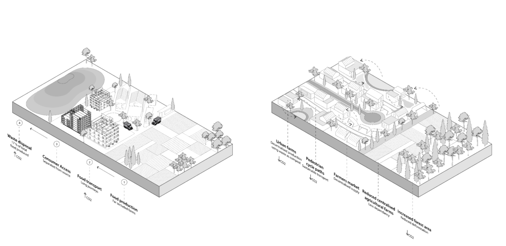
The food system encompasses four major stages, namely; Food production, food transport, consumer access, and waste disposal. The business-as-usual system is a linear system where the end of this system lies in the huge mounds of landfills contributing to more GHG emissions. Due to this linearity, the overall transportation and hence CO2 emissions also increase in all stages, i.e. production, distribution, procurement, and disposal. FSPUD aims to make these systems more decentralized and make cities more self-sufficient by transforming these linear systems into various small circular loops. The diagram showing the two concepts is as follows:
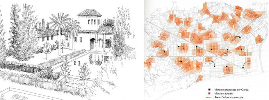
As shown in the pictures below, the gardens of the Alhambra in Granada, Spain, were built in the 14th century. The gardens were designed with Food-producing objectives. It incorporated elements like ponds stocked with fish and Food-producing trees. Also, the map of Barcelona of the markets projected by Cerdà; nowadays system market in Barcelona, shows areas of influences of the markets and highlights the end of the public granaries or grain stores, typical of the traditional city, which marked the passing from a very focused concern about staple food supplies to a situation characterized by greater abundance in which consumer habits
Source: Food-sensitive planning and urban design: A conceptual framework for achieving a sustainable and healthy food system. (2011). David Lock Associates, University of Melbourne, National Heart Foundation of Australia and
Guàrdia, M., Bañales, J. L. O., & Nadia, F. (2010). Retailing and proximity in a liveable city: the case of Barcelona public markets system.
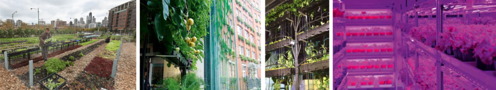
Source: Plumer, B. (2016, October 12). The real value of urban farming. (Hint: It’s not always the food.), Vox,
and Green Blue urban, (Autumn 2016), Urban Design Group Journal
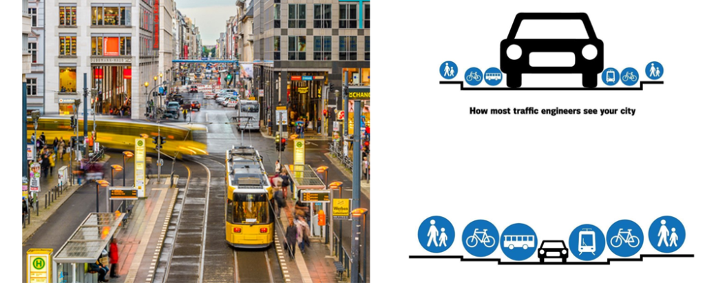
Sustainable transport
Any kind of transportation that has a minimal impact on the environment is considered a sustainable transport system. To develop and preserve urban transportation networks, it incorporates carsharing, walking, cycling, mass transit-oriented development, green vehicles, and encouraging healthy lifestyles. Sustainable transportation addresses sub-health issues among the populace, environmental harm, and potentially hazardous modes of transportation. One of the primary strategies for transportation development nowadays is sustainable transportation.
Sustainable transportation refers to low- and zero-emission, energy-efficient, and affordable modes of transport, including electric and alternative-fuel vehicles, as well as domestic fuels.
Sustainable development applied to transport systems requires the promotion of linkages between environmental protection, economic efficiency, and social progress.
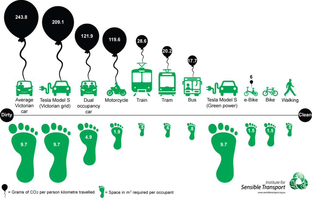
Source: Institute for Sensible Transport, (2018, April), Transport, Greenhouse Gas Emissions and Air Quality, City of Melbourne
Global South and Global North
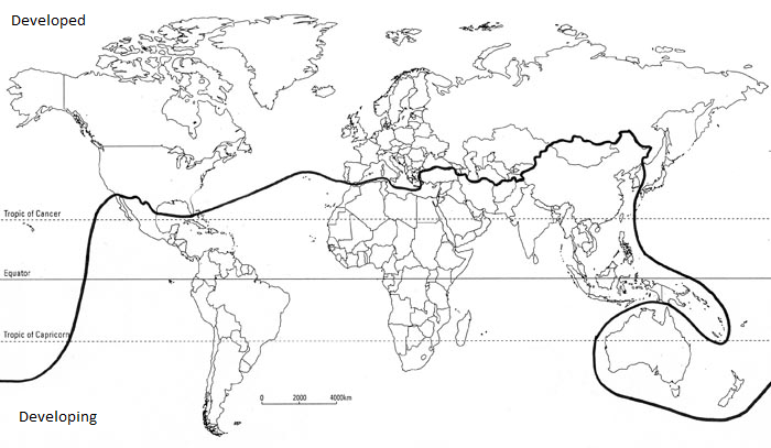
A visual representation of global inequality and the socioeconomic divide that divides nations, known as the “Brandt Line,” gained popularity in the North and South: A Programme for Survival—the Brandt report, to be precise first chaired by Willy Brandt, in 1980. The Brandt Line, which divides the world into the wealthy Global North and the poorer Global South by snaking across continents, has been one of the most recognizable and significant methods to visualize world politics for forty years. However, some may argue that the Brandt Line has lost its significance. Illustrating the globe as a split bloc consisting of the industrialized North and the developing Global South may no longer accurately reflect global political reality, if it ever did.
The Brandt Line may have been eliminated, or at least greatly obscured, by the rise of emerging economies, global economic integration, and the creation of a new international division of labor. Regardless of our gut feelings on these matters, the best available data should be used to assess the Brandt Line’s usefulness. Examining whether the Brandt Line accurately depicts the main political and economic divide in the modern world is possible in light of the Brandt Report’s 40th anniversary.
The phrase “Global South” is said to have been first used in 1969 by American writer and New Left activist Carl Ogelsby. During the height of the Vietnam War, he wrote in the Catholic journal Commonweal that “the North’s dominance over the global South… [has] converged to produce an intolerable social order.”
Source: Lees, N. (2021). The Brandt Line after forty years: The more North–South relations change, the more they stay the same? Review of International Studies, 47(1), 85–106.
The availability of natural resources, varying health and educational standards, the makeup of an economy and its industrial sectors, access to markets and international trade policies, national and international relations, internal and international conflict, and a nation’s susceptibility to natural disasters and climate change are just a few of the many factors contributing to these disparities.
The term “Global North” refers to the relative strength and affluence of nations in various parts of the world rather than a specific geographic area in the conventional sense. It is important to remember that while the Global North is generally strong and affluent, it is not a homogenous group. Because of the internal stratification and diversity of its societies, not everyone in the Global North is wealthy and powerful.
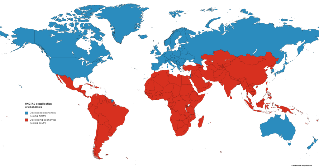
Source: Wikimedia Commons. (2023, October 20). UNCTADClassificationofeconomies.png
Southern Urbanism
While the first instinct is that we have a geographical territory in mind — so everything outside of the West — that geography is only part of the story: “It’s only a part of the story in the sense that it captures where the majority of urban dwellers will live in next 30 to 40 years as we know that 95% of urban growth will be in Asia and Africa between now and 2050.” This, he underscores, is significant and happens at a moment when the world economy is changing; in which we understand environmental limits and that how we have conceptualized and experienced cities is just not an option for the future. This contextual relevance is one piece of the argument.

(Right) The first wave of Urbanization in the global North,
Source: UN-HABITAT WORLDWIDE. (2014, April 22). Edgar Pieterse. How can we transcend slum urbanism in Africa?
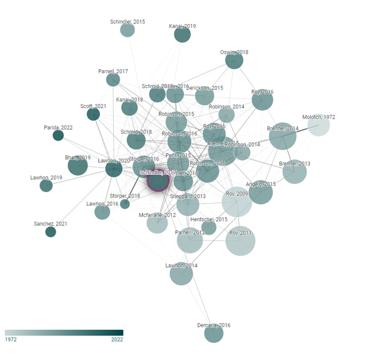
Source: Connected Papers | Find and explore academic papers.
