
Dhaka, the bustling capital of Bangladesh is at a critical juncture in its urban development. With a population exceeding 10.4 million, the city faces significant challenges in housing, transportation, and environmental sustainability.
This project is a part of a comparative analysis done by the students, understanding these challenges under the framework of SDG 11 – Make cities and human settlements inclusive, safe, resilient and sustainable.
Population Growth – 2000-2020
Dhaka City has a population of 10.4 million, and the Dhaka Metropolitan Region houses 23.9 million. Its 3.67% growth rate is fueled by rural-to-urban migration for better jobs and services. As Bangladesh’s economic and cultural core, Dhaka faces infrastructural strains, including congestion and housing shortages, due to this migration.

Geographical Constraints
Surrounded by rivers and their tributaries, Dhaka’s natural expansion is significantly limited. The administrative borders of the city are defined by these rivers, which means that population growth has largely been constrained within existing urban areas. This geographical limitation leads to high population densities, creating several infrastructural strains.
Congestion: The city’s roads and transportation systems are overwhelmed by the number of residents, leading to severe traffic jams and long commute times.
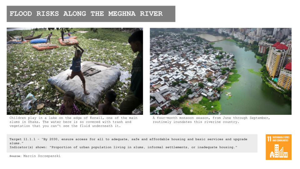
Housing Shortages: Limited space for expansion means housing cannot keep pace with the growing population. As a result, many people live in overcrowded and informal settlements, which often lack basic amenities.
Inadequate Public Services: The high population density puts immense pressure on public services such as water supply, sanitation, healthcare, and education. These services are often insufficient and unable to meet the needs of all residents.
Pollution: The concentration of people and activities in a limited area contributes to significant environmental pollution. Air quality is compromised by vehicle emissions and industrial activities, while water pollution is exacerbated by inadequate sewage and waste management systems.
Vulnerability to Flooding: The proximity to rivers and flat terrain makes Dhaka highly susceptible to flooding. This is worsened by poor drainage systems and the encroachment of urban development into natural water retention areas.
The above identified issues highlights the need of meeting multiple SDG goals, all of which are interlinked with the SDG 11, which has various targets to meet and indicators to quantify the overall success of a city with respect to the goal..
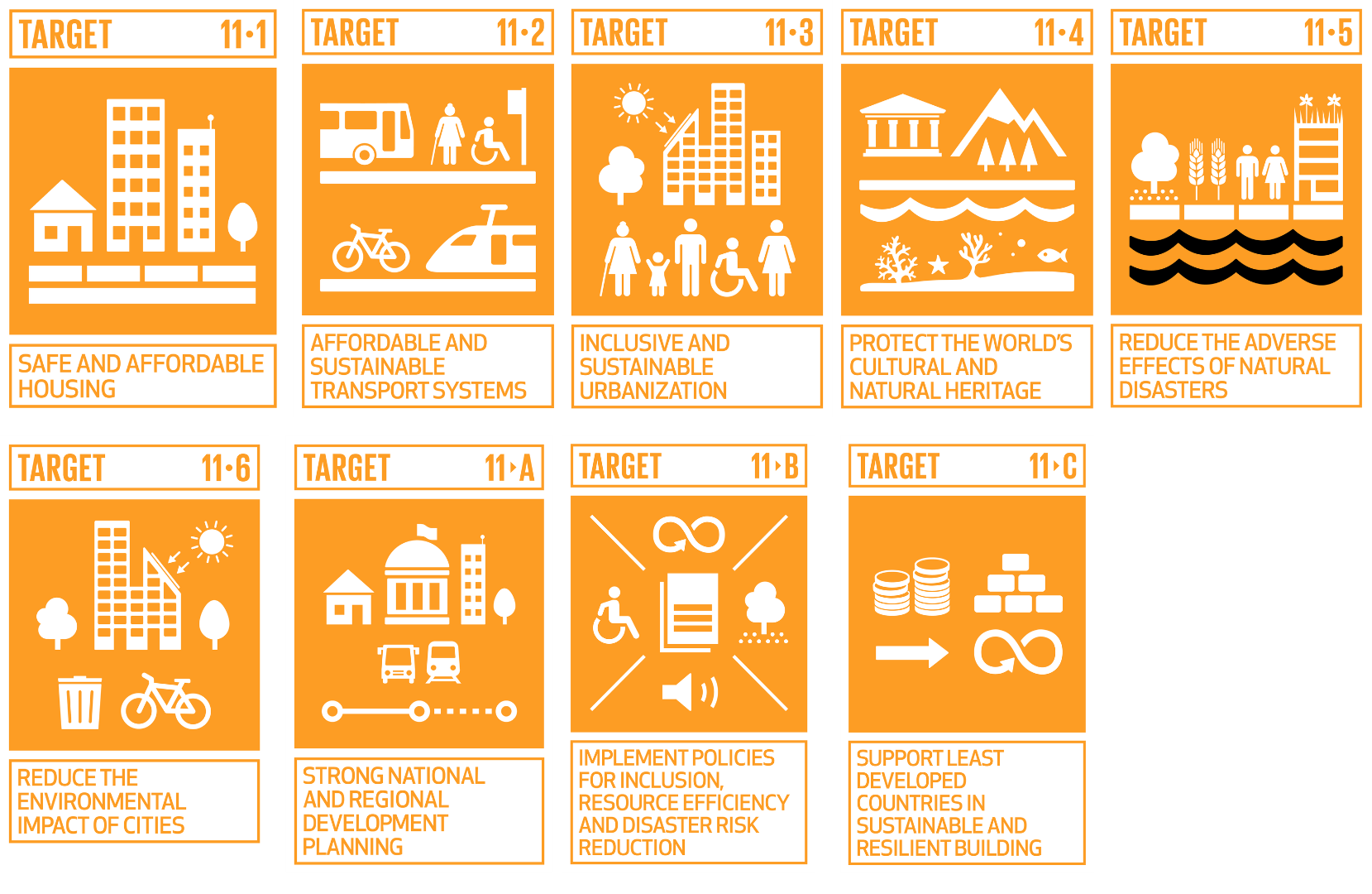
However for the purpose of this exercise we shall focus on addressing, Target 11-1 – Safe and Affordable Housing & Target 11-5 – Reduce the Adverse Effects of Natural Disasters.
Each of these targets have statistical indicators which can be measured or in this case mapped to understand the city’s current position in terms of meeting the SDGs. These indicators are often perceived to be collected globally, however not all countries record the data appropriately for convenient mapping so we have tried to use published maps/documents and satellite imagery to understand the characterstics of the city.
However first we would understand how to government structure in the country works.

Dhaka Metropolitan Region Jurisdiction Structure
Jurisdiction and Functions of Local Governments in Dhaka
In Dhaka, jurisdiction is divided between rural and urban local governments.
Rural local governments, called Union Parishad and Upazila Parishad, focus on development and services for villages and rural areas. They handle agriculture, basic services, and local administration.
Urban local governments, including City Corporations and Municipalities, manage complex urban challenges across cities and towns, such as city-wide services, urban planning, infrastructure, and waste management.
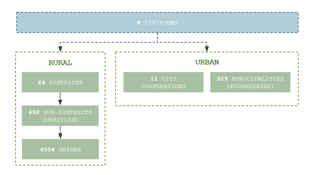
Scale and Services
Rural governments operate at a smaller scale, serving lower-density areas primarily focused on agriculture.
In contrast, urban governments manage higher-density areas, addressing diverse urban needs with more complex infrastructure projects like roads and public transportation.
Population Density
Urban local governments cater to areas with higher population densities, requiring diverse and extensive services.
Rural governments serve areas with lower densities, focusing on essential services tailored to agricultural communities. This differentiation ensures that governance and services are appropriately scaled and targeted to meet the specific needs of rural versus urban populations.
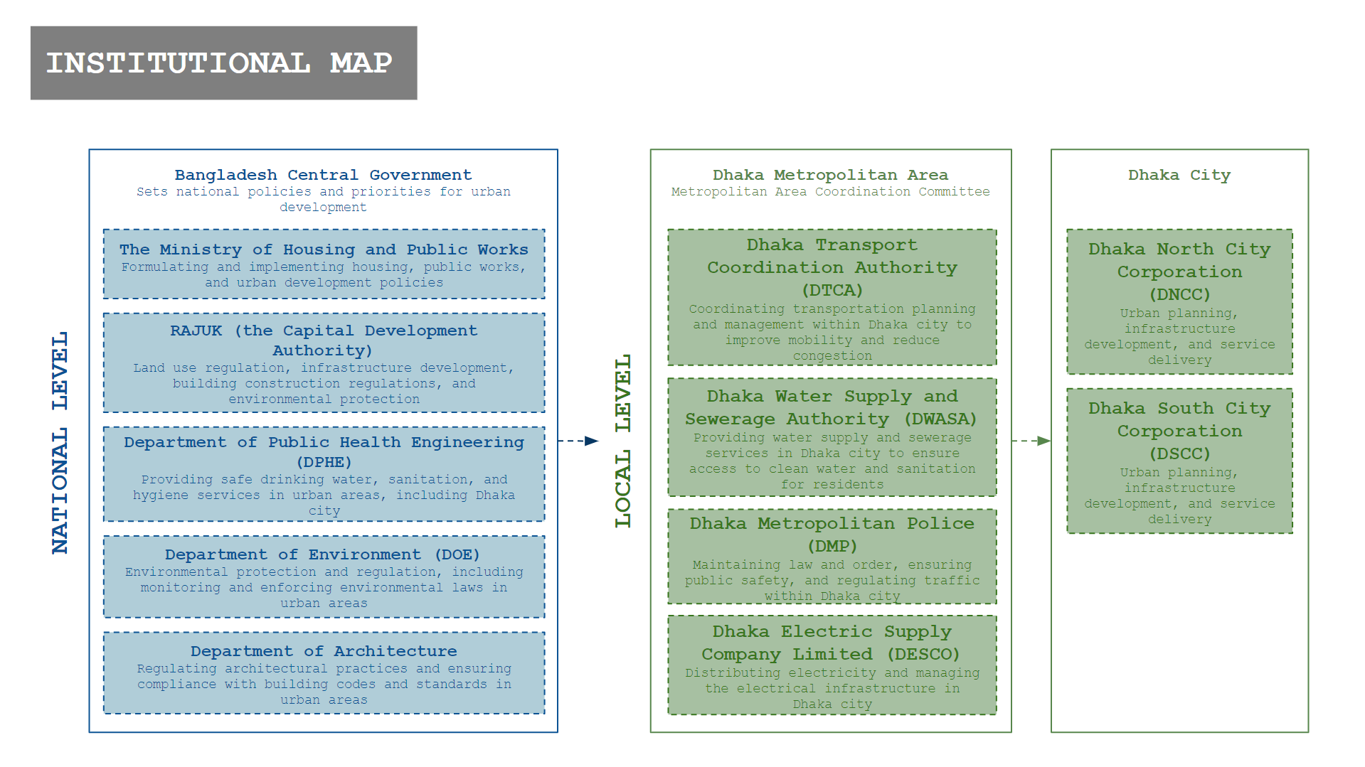
This institutional map categorizes Dhaka’s urban development entities by national and local levels. At the national level, departments like Housing and Public Works set broad policies, while local entities such as the Dhaka Transport Coordination Authority handle specific city services like transportation and water supply, ensuring effective urban management in Dhaka.
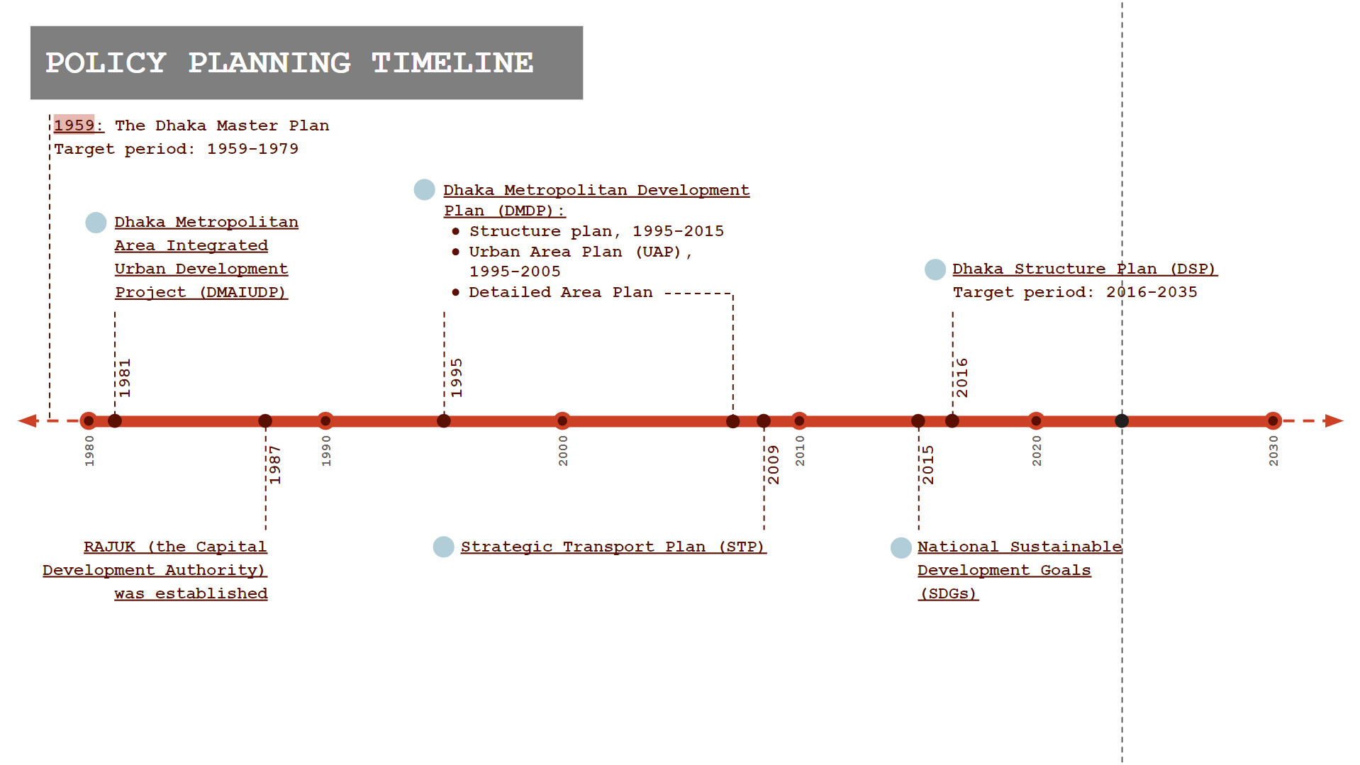
This timeline outlines the major urban planning milestones in Dhaka, starting with the 1959 Dhaka Master Plan through to the ongoing 2016-2035 Dhaka Structure Plan, highlighting significant developments like the Dhaka Metropolitan Development Plan and Strategic Transport Plan.
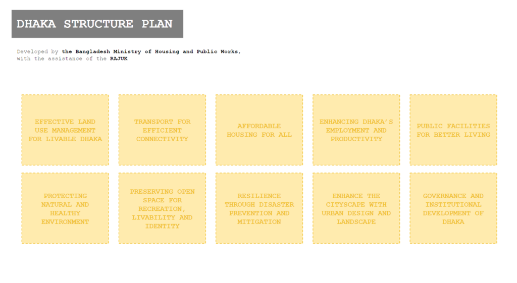
This visually highlights the key components of the Dhaka Structure Plan developed by the Bangladesh Ministry of Housing and Public Works with RAJUK’s assistance. The plan focuses on various urban development goals such as effective land use, affordable housing, environmental protection, improved public transportation, enhanced urban design, and strengthened governance to ensure a liveable, productive, and resilient Dhaka.

This image presents the Dhaka City Structure Plan (2016-2035), illustrating the strategic transition from a concentric to a polycentric urban structure. The plan includes a map highlighting different urban centers and strategic zones across Dhaka. It details the diffusion of major functions from the central city to various urban centers to better manage growth and improve transit systems. The key components shown include areas designated for regional centers, specialized centers, and community centers, along with zones for agriculture, conservation, and general urban growth. Source : Dhaka City Structure Plan (2016-2035) & Strategic Transport Plan.
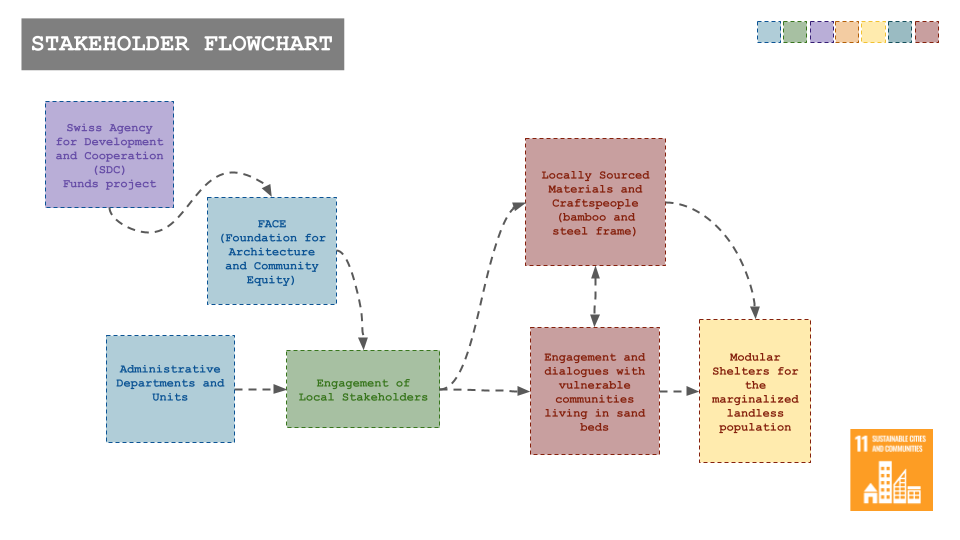
Dhaka’s localization of Sustainable Development Goals (SDGs) consists of various entities and stakeholders that play a role in implementing interventions.

This diagram illustrates the SDG Localization Framework in Bangladesh, detailing the process of integrating Sustainable Development Goals (SDGs) into local governance structures. It outlines the roles of the major tasks by local government, the formation of an SDG Implementation Committee (SIC), and the engagement of local stakeholders. The framework emphasizes the importance of planning, coordination, and strengthening local government through decentralization and increased national support.
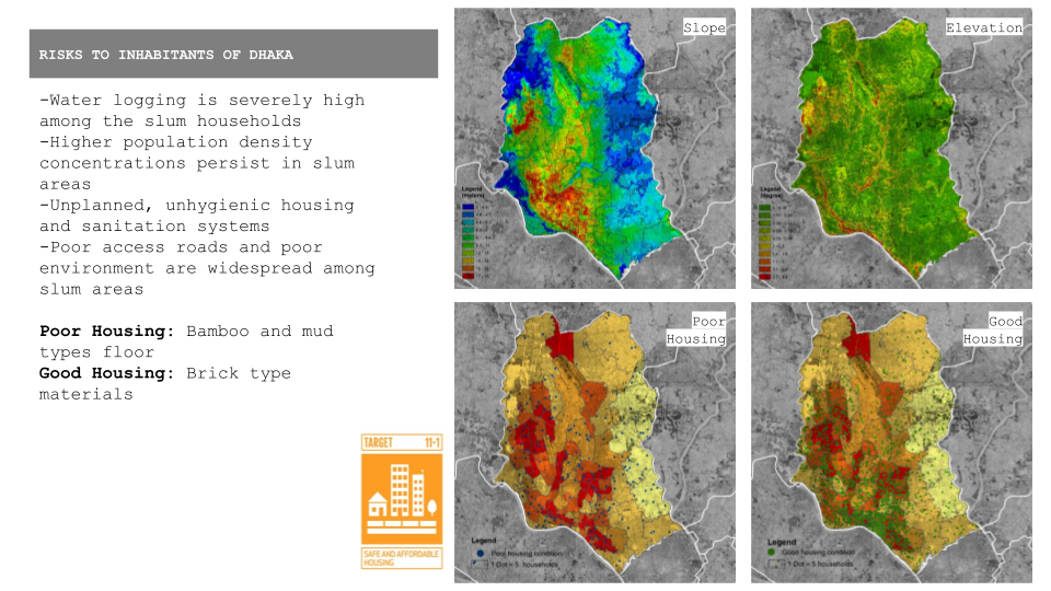
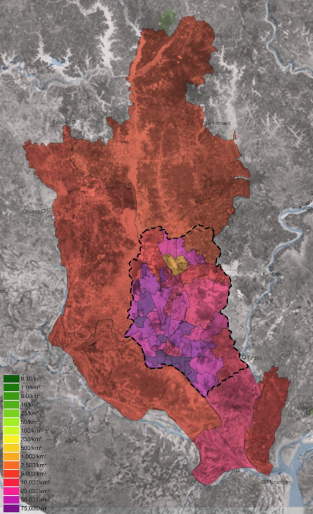
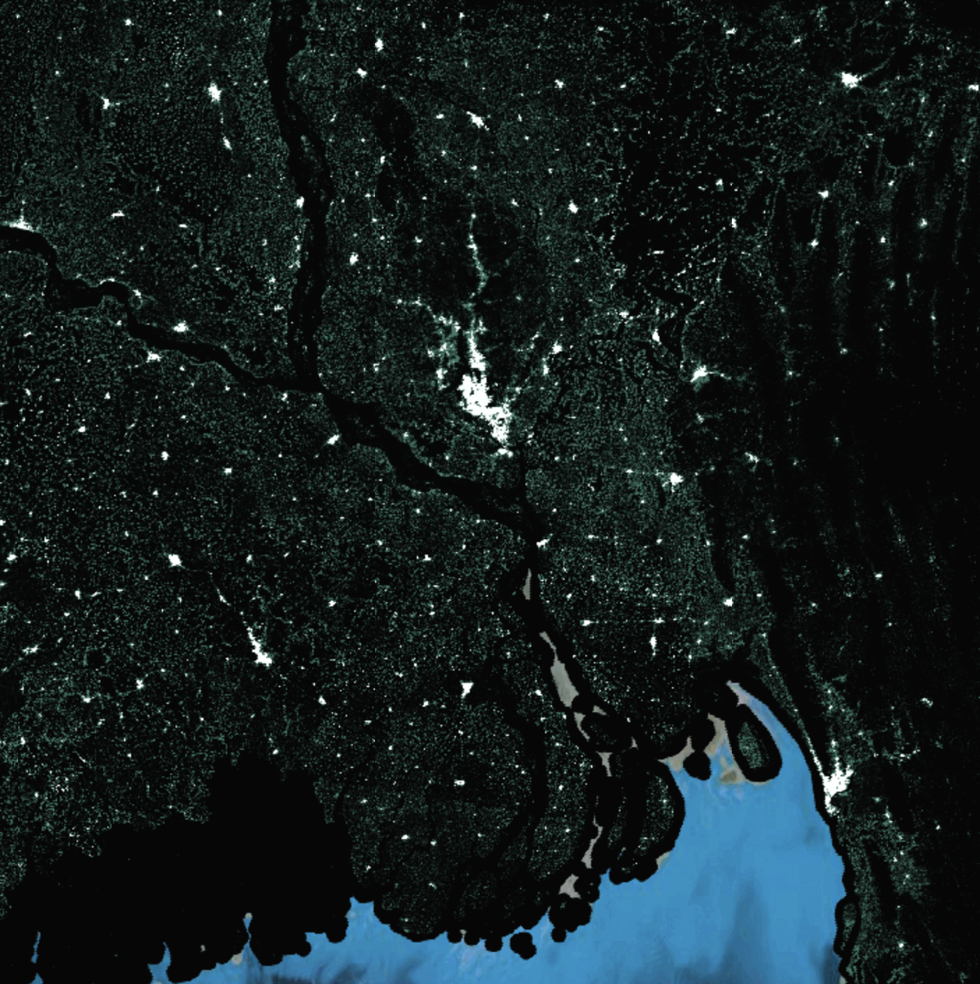
This image analyzes the housing conditions and geographical challenges in Dhaka, linking them to SDG 11.1 (Safe and Affordable Housing) & SDG 11.5 (Reduce Adverse Effects of Natural Disasters). It features maps showing Dhaka’s topography, including slope and elevation, which affect urban planning and flood risk. The bottom maps categorize areas by housing quality, distinguishing between poor housing (bamboo and mud) and good housing (brick). These visuals underscore the disparities in living conditions and the need for infrastructure that can cope with Dhaka’s geographic and social complexities. Source : Published maps in Dhaka city documents.
As of 2020, 52% of Dhaka’s population lived in slums. Ranked number 137 out of 140 in the list of world’s livable cities. Dhaka Metropolitan Area – Informal settlements classified by density, shape & context indicators. As of 2020, 52% of Dhaka’s population lived in slums. Ranked number 137 out of 140 in the list of world’s liveable cities. Dhaka Metropolitan Area – Informal settlements
Lessons Learned
What is the physical barrier limiting Dhaka from addressing its housing needs, and how can it be adapted?
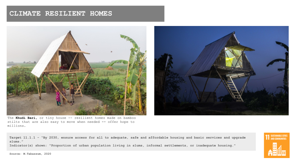
Dhaka is significantly affected by its proximity to the Sunderban Delta and flat terrain, which increase susceptibility to flooding due to the sea level being 0 at many parts of the city. This geographical constraint, along with rivers defining administrative borders, restricts urban expansion. Adapting to these barriers could involve integrating flood-resilient infrastructure and elevated housing solutions into urban planning. The low-lying areas and those in proximity to the river could be the areas in need of immediate intervention.
What limitations were identified in the documents, and how aligned are they with the SDGs?
The planning documents for Dhaka outline extensive policies that align with the SDGs. However, a major limitation is the lack of effective interdepartmental communication and the absence of detailed, actionable data. This gap hinders precise implementation and monitoring of SDG-aligned strategies, emphasizing the need for improved data collection and integration.
Sources
- Satellite Imagery & Data – Google Earth Engine Datasets
- Published Maps and City’s Strategic Documents – National Database
- Spatial Data – OSM
