
Poblenou, Barcelona
The project focused on a specific site in the district of Poblenou, which has been identified as the one who has the most problematic street conditions. Traffic accidents, asphalt, no liveability and no safety. “Growing sidewalks” proposes a design strategy to change this, projecting into the needs of the future.
Site overview and analysis_
Poblenou, an area of innovation within the Sant Marti district. From an industrial area in the 19th century – to a state of abandonment – towards a fast growing, technological innovation district, with a focus on business, education, culture, leisure and living – also known as 22@Barcelona.
Poblenou is located between the great beaches of Barcelona and has a high proximity to the city centre aswell to it’s four beaches, Platja de la Nova Icaria, del Bogatell, de la Nova Marbella & de Llevant.
Mobility status quo_
Vehicle dominated roads, especially the Avinguda Diagonal, the second diagonal road, Carrer de Pere IV fragment the existing block structure in Poblenou and mainly function as single way roads.
We discovered a high performative connection to public transport, a 4′ min walk to the Llacuna (L4) subay, a 14min’ walk to the closest tram station Ca’ Aranyó and several bus stations nearby, aswell as on our choosen site.
Also, seen from a larger scale – a well developed infrastructure for cyclist mobility, especially around the more balanced streets of Carrer de Pujades and around the “Rambla Poblenou”. Taking a closer look though, on a smaller scale, the bike lanes are fragmented, especially around our chosen site in Carrer Pere IV.
Project site & neighbourhood area_
Regarding vehicle mobility, the Carrer de Pere IV forms into a bottleneck alike situation, narrowing down the street width and yet still being oversized in relation to the measured traffic volume.
We discovered a site within a state of transformation – with a new high rise residential building being constructed to the north and a recently completed office building in the east, an abandoned industrial complex in the south and residential buildings around in bad conditions, likely to be replaced soon.
Existing Condition_
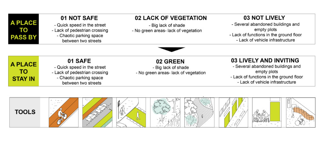
The spatial analysis and the visit to the site in the peak hour revealed that selected case study area is affected by a huge variety of problems:
- People crossing the street without traffic lights for pedestrians.
- Chaotic parking island in the middle of the street providing a limited number of parking spaces and increasing the access from one side of the street to the other.
- Lack of planted trees and shadow causing discomfort to the pedestrians.
- Not clearly defined parking, causing issues such as narrow driving lanes and difficulty to pedestrian mobility.
Those issues are expected to be even more problematic in the following years since this neighborhood is transforming from an industrial area to an area of residential and office buildings. By having in mind this increase of population we are aiming at redesigning this area by growing the sidewalk size and providing the pedestrians with a better microclimate and more friendly public spaces.
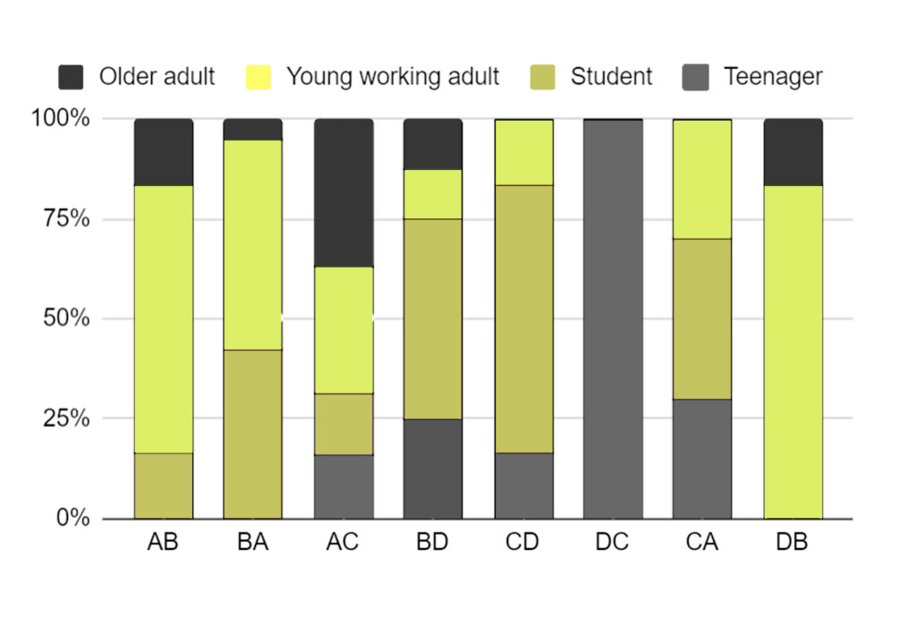
User types_
Steps_
The project has suggested closing one part of the street, turning it into a pedestrian area. This proposal has been made taking into the consideration the fact that this place has a low traffic and a great connectivity to the public transport. In the future, this specific street segment would be scaled up in the nearby streets.
Taking into consideration the problematic situations that we identified during the analysis process and the site visit as well, we follow a step-by-step procedure in order to convert that street segment into a more viable, safe and pedestrian friendly environment.
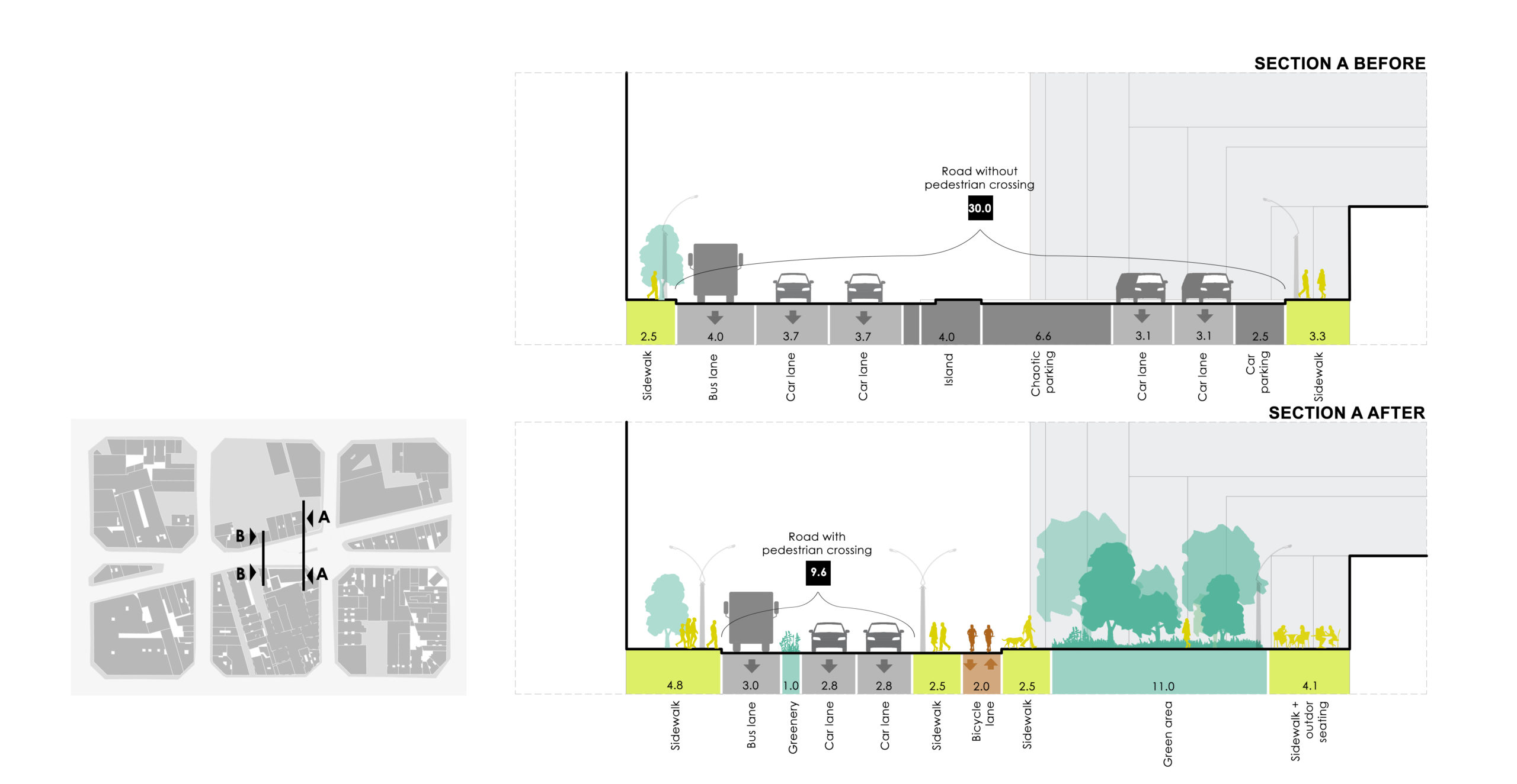
1. Expansion of the pedestrian sidewalks on both sides of the road. In the left part of the street, we convert the existing parking island into a pedestrian one and combined with the extended sidewalks form the new urban spaces and paths not only for the pedestrians but also for the autonomous delivery robots.
2. Generation of 2-way bicycle paths. A new bike lane of 2 meters length is created in order to connect the shattered parts of the existing bicycle network in the neighborhood. The placement of it next to the left sidewalk of the street, creates a smooth transition between the pedestrian and the car friendly part of our site.
3. Organization of street part that is occupied by cars. The existing bus lane is expanding to 4 meters length while the 3 drive lanes are converted into 2, extending each of their length to 3.7 meters. Additionally, on both sides of the street part, 2 parking lanes are generated providing in total 8 parking spaces for cars as well as spaces for micro mobility vehicles. The road marking afterwards plays an important role in the shaping of the new street environment in order to avoid confusions. Apart from that we introduce two new areas, a pedestrian island and a traffic median in order to provide a more safe environment to pedestrians.
4. Define pedestrian crossings. The existing arrangement of the pedestrian crossings creates a confusing and unsafe environment as in terms of time and space/distance waste, the majority of pedestrians don’t follow it. For this reason, our proposal suggests the placement of a new crossing area in the last part of the street segment before the second intersection and the reshape of the existing one in the first part.
5. Define green zones. Trying to convert that kind of asphalt and concrete based environment into a green-environmentally friendly one, we introduce and define new green areas/zones in the neighborhood as well as we increase the tree canopy over the street segment.
Proposed Scenario_
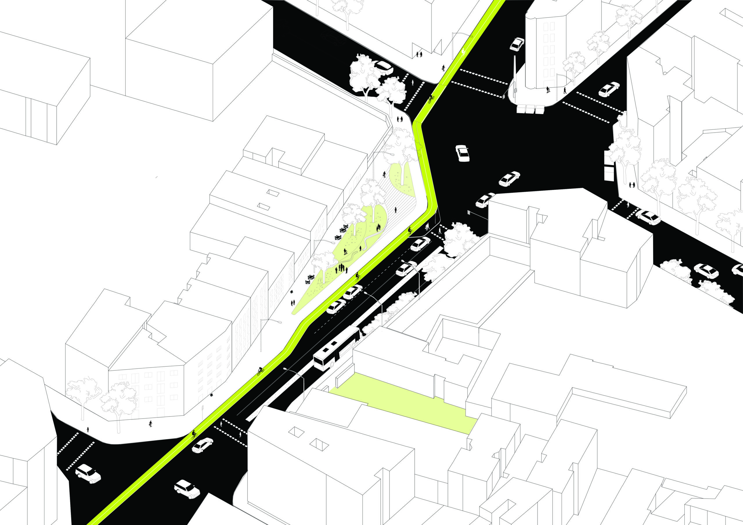
The proposed scenario has tackled three main issues of the street- lack of safety, liveability and greenery. As a result, we have proposed a large green space on the extended part of the sidewalk giving the opportunity for social interaction to the future users of the neighborhood.
Essentially, we also created a new crossing linking the two sides of the street reducing the waiting time of pedestrian mobility around the block.
Massmotion_
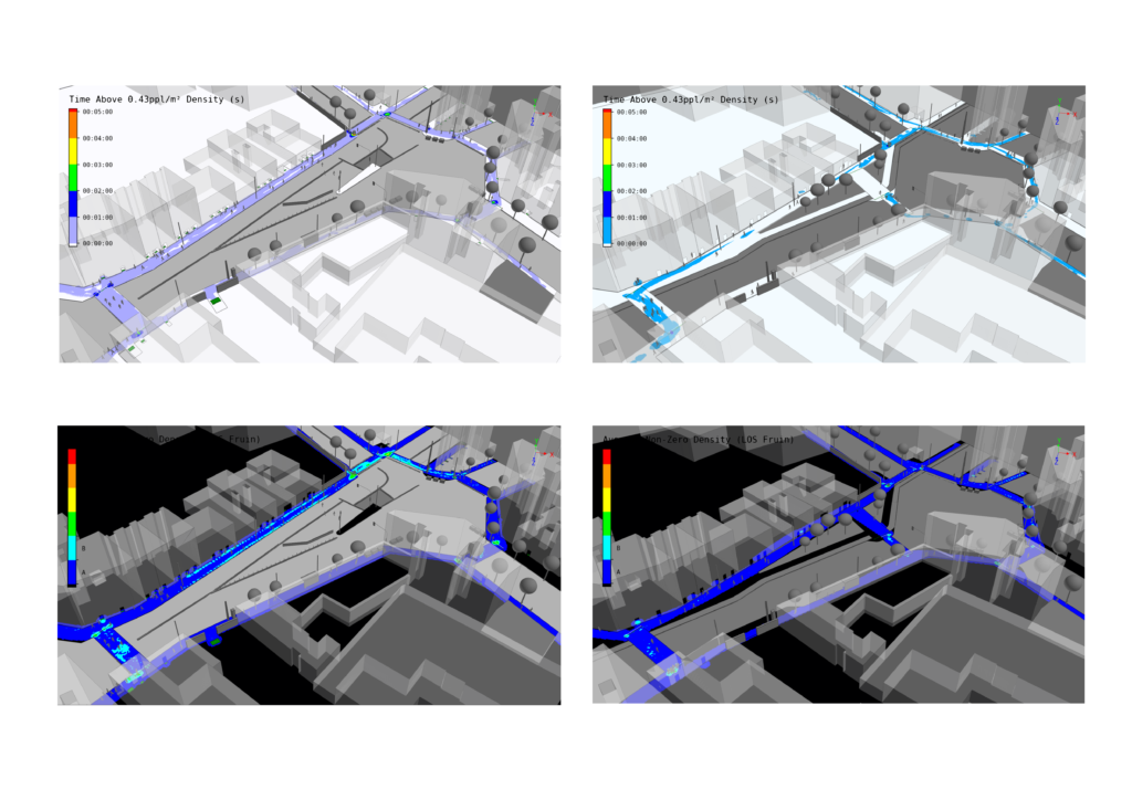
The project has used Massmotion software in order to simulate the flows of pedestrians in a newly designed area. On the left you can see the simulation we did for the existing condition of our selected area and on the right you can see our proposal. By re-adjusting our origin-destination matrix with 25% of population growth on the right we can see that waiting time and congestion for pedestrians have been improved by adding a new crossing in place of the old parking island.
