
The research visualisation map shows the meaning, value, and governance of land shift as it transitions from the physical world into the metaverse. It treats land not as a static material object but as a socio-technical construct whose definition changes with different forms of infrastructure, ownership systems, and human–technology relationships. In the physical world, land meaning emerges through geography, history, regulations, and settlement patterns. In the metaverse, it emerges through code, programmed scarcity, network effects, and digital economies. By placing Barcelona’s physical fabric beside the grid of Decentraland, the visualisation positions land as an interface—spatial, economic, symbolic, and programmable—rather than something tied solely to soil or territory. The composition intentionally brings together centuries-old cartographic representations with modern virtual land markets to show how ideas such as scarcity, clustering, speculation, and status signalling move across contexts and are reproduced rather than invented.
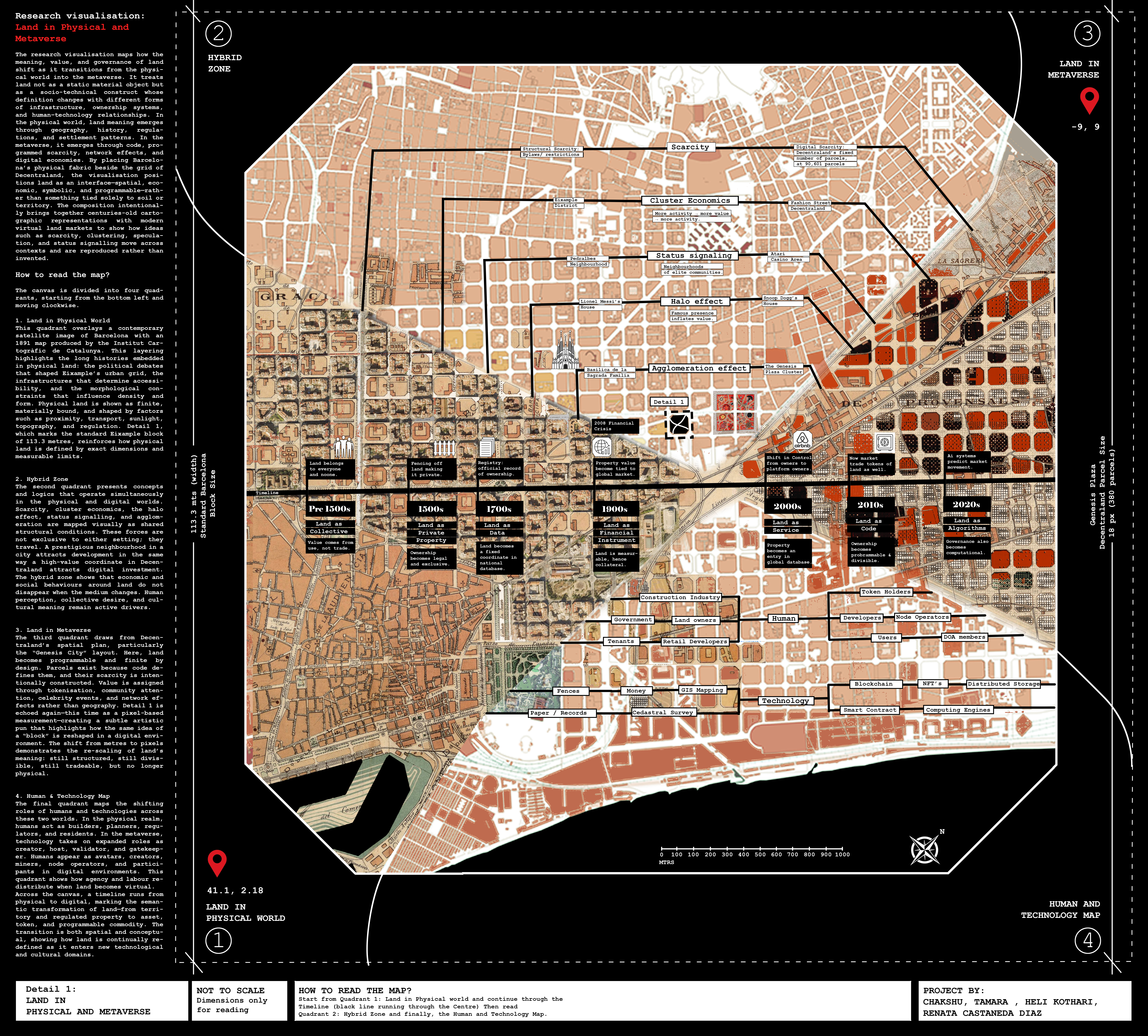
How to Read the Map?
The canvas is divided into four quadrants, starting from the bottom left and moving clockwise.
1. Land in Physical World
This quadrant overlays a contemporary satellite image of Barcelona with an 1891 map produced by the Institut Cartogràfic de Catalunya. This layering highlights the long histories embedded in physical land: the political debates that shaped Eixample’s urban grid, the infrastructures that determine accessibility, and the morphological constraints that influence density and form. Physical land is shown as finite, materially bound, and shaped by factors such as proximity, transport, sunlight, topography, and regulation. Detail 1, which marks the standard Eixample block of 113.3 metres, reinforces how physical land is defined by exact dimensions and measurable limits.
2. Hybrid Zone
The second quadrant presents concepts and logics that operate simultaneously in the physical and digital worlds. Scarcity, cluster economics, the halo effect, status signalling, and agglomeration are mapped visually as shared structural conditions. These forces are not exclusive to either setting; they travel. A prestigious neighbourhood in a city attracts development in the same way a high-value coordinate in Decentraland attracts digital investment. The hybrid zone shows that economic and social behaviours around land do not disappear when the medium changes. Human perception, collective desire, and cultural meaning remain active drivers.
3. Land in Metaverse
The third quadrant draws from Decentraland’s spatial plan, particularly the “Genesis City” layout. Here, land becomes programmable and finite by design. Parcels exist because code defines them, and their scarcity is intentionally constructed. Value is assigned through tokenisation, community attention, celebrity events, and network effects rather than geography. Detail 1 is echoed again—this time as a pixel-based measurement—creating a subtle artistic pun that highlights how the same idea of a “block” is reshaped in a digital environment. The shift from metres to pixels demonstrates the re-scaling of land’s meaning: still structured, still divisible, still tradeable, but no longer physical.
4. Human & Technology Map
The final quadrant maps the shifting roles of humans and technologies across these two worlds. In the physical realm, humans act as builders, planners, regulators, and residents. In the metaverse, technology takes on expanded roles as creator, host, validator, and gatekeeper. Humans appear as avatars, creators, miners, node operators, and participants in digital environments. This quadrant shows how agency and labour redistribute when land becomes virtual.
Across the canvas, a timeline runs from physical to digital, marking the semantic transformation of land—from territory and regulated property to asset, token, and programmable commodity. The transition is both spatial and conceptual, showing how land is continually redefined as it enters new technological and cultural domains.
Video Project
In recent years, the boundary between physical and digital worlds has blurred, reshaping ideas of value, place, and identity. Our video project explores this duality through a journey inside Decentraland, guided by a polished, slightly self-aware virtual assistant who mirrors the AI systems increasingly mediating real-world decisions. Framed against the backdrop of an unaffordable property market, the assistant introduces virtual land as an alternative arena where scarcity, speculation, and cultural influence operate much like physical real estate—illustrated through humorous, data-driven moments such as a parcel’s value rising after Snoop Dogg became a virtual neighbor. As viewers explore districts and parcels, the narrative highlights how emotional attachment and community can form even in pixelated spaces. The final twist arrives during the purchase process, where a “free” payment option requires full data access and constant surveillance, exposing the hidden costs of digital convenience. Ultimately, the video reflects on how expanding virtual territories offer new opportunities while raising critical questions about data ethics, ownership, and what we trade as we inhabit hybrid realities.
