Viladecans greeted us with an unexpected tranquility. We arrived to the city on the commuter train from Barcelona, opposing the flow of morning commuters. The station was empty. A single street, lined with abandoned plots and industrial sheds led us up the hill into the town. A few hundred metres later the scene couldn’t be more different. The town was full of lively cafés, shops, and people strolling through the streets.
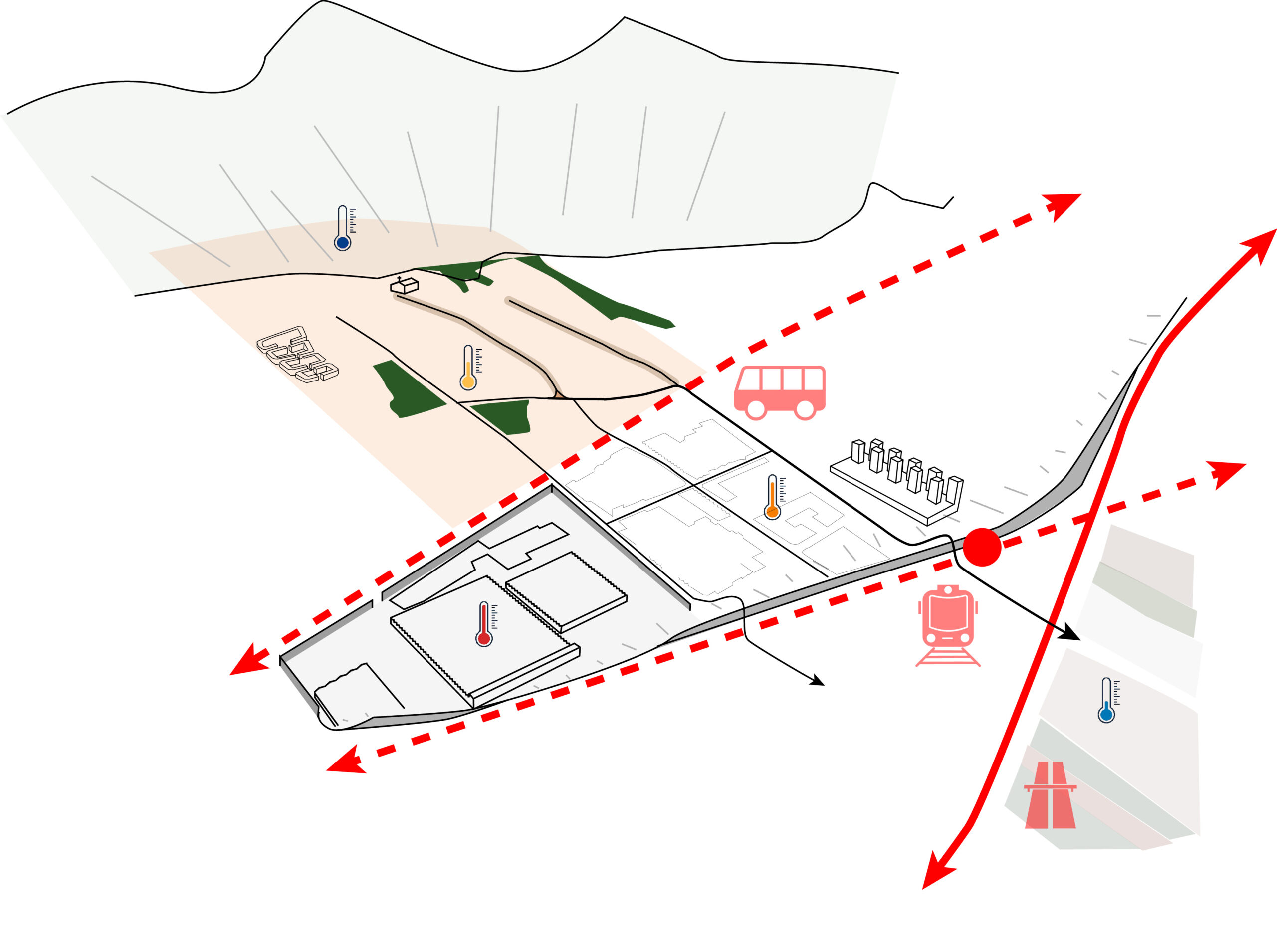
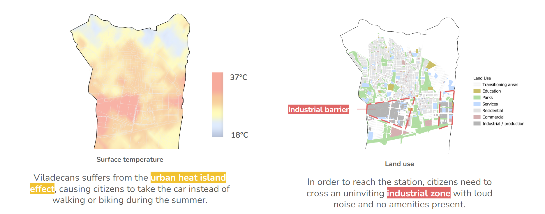
The curious spatial gap between the station and the urban center can be explained by the fact that the Viladecans station was an afterthought in the urban planning of Baix Llobregat. Initially, the railway line only connected Barcelona with Gavà, creating a zone between the existing string of towns and the railway line that was subsequently given an industrial function by the 1976 metropolitan masterplan. In the 1980s, Viladecans managed to realize a station on the line, but it was only at the beginning of this year that Viladecans was fully integrated into the timetable as a stop for each train. Currently, the space between the town center and the train station suffers from the urban heat island effect and lacks the mix of functions that are the basis of good street life. For these reasons, many commuters choose to use the car or motorbike to get to the station, instead of walking or cycling.
According to a source at the urban planning department of the municipality, 70% of the Viladecans’ working population commutes to workplaces outside of the municipality. The train table change could thus have a huge effect on the future spatial organization of Viladecans and its goals to shift to sustainable modes of transport.
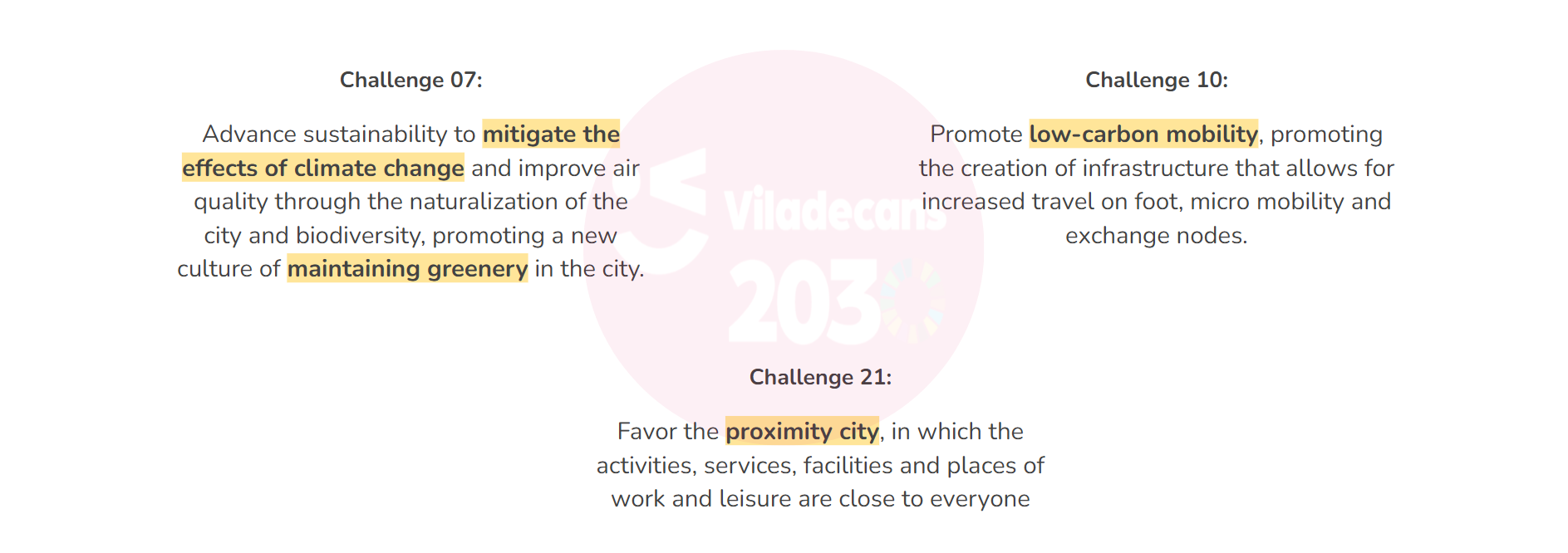
But how can we enhance the opportunity in Viladecans to transition into carbon-neutrality by 2040?
Reducing the use of private transportation among Viladecans’ dwellers by improving the street conditions and connections to the train station, and by fostering new jobs in the industrial polygon.
This project directly tackles Viladecans’ multifaceted goals for a more sustainable and connected city by strategically transforming the area surrounding the train station. Our approach focuses on reducing reliance on private vehicles among residents and is connected to Viladecans 2030 Strategy.
Proposing Places to stay: Unlocking Viladecans’ Potential Through Strategic Development
Viladecans sits at a crossroads of opportunity. Its proximity to Barcelona and underutilized railway connection present a unique chance to transform the city and provide workplaces and homes at an affordable land price. This potential could in turn be mobilized by the municipality to drive the climate adaptation and mitigation of the existing city.
Following this vision, we have developed a multiscalar approach:
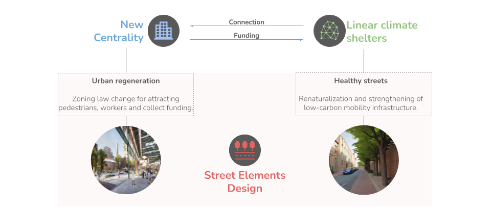
- New Centrality Proposal: This outlines the development plan for the new central area near the station.
- Climate Shelter Network: This details the design and implementation of the green corridors connecting the new centrality to existing neighborhoods.
- Street Transformations: This focuses on specific case studies, showcasing how existing streets within the network will be transformed to prioritize pedestrians, cyclists, and community vibrancy.
A New Centrality
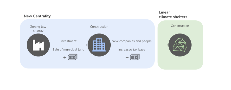
The driver of the transformation of Viladecans will be a zoning law change which will allow the construction of mixed-use developments on current abandoned and industrial plots.
Currently, the neglected area leading to the Viladecans station is dominated by industrial and logistics uses (47%), with an extensive amount of car-designated spaces (29%). The remaining space is a mix of transitional areas (15%) and small, fragmented parks (9%). This imbalance creates an unpleasant and unsustainable environment.
Our initial proposal reimagines this centrality by prioritizing a people-centric approach. We aim to reduce the industrial and logistics footprint to a more balanced 30-40%. Crucially, car space will be significantly reduced to just 15%. This freed-up land will be transformed into dynamic mixed-use areas (20-30%). These areas could include a combination of housing, shops, restaurants, and cultural spaces, fostering a lively and walkable community. Finally, the proportion of green space will be significantly increased to 20-25%, creating parks and gardens that will contribute to mitigating the urban heat island effect. By reducing car lanes and parking, and prioritizing public space and mixed-use development, we aim to create a new centrality that is functional and enjoyable, creates in-town jobs, and enhances low-carbon mobility towards the station.
Linear Climate Shelters
To seamlessly connect the existing city to the new centrality, we propose a network of linear climate shelters. These shelters won’t just provide shade – they’ll create a network of green corridors, making walking and cycling to the station a cooler, more enjoyable experience.
We strategically designed the network by calculating the shortest paths from residential areas to the station, and prioritizing streets according to the following characteristics:
- Green Factor: We incorporated a “green score” based on NDVI (Normalized Difference Vegetation Index), a measure of plant health and green cover. This prioritizes streets with existing trees or areas where additional greenery can be easily integrated.
- Cycling Infrastructure: We factored in existing bike lanes, giving them a higher weighting in the selection process. This leverages existing infrastructure and encourages continued cycling use.
- Traffic: We considered the shortest paths from residential areas to the station to identify streets with higher usage. Prioritizing these paths ensures the network connects areas with the most demand.
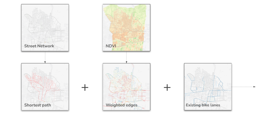
By combining these factors, we created a “priority score” for each street. Streets with a high score – those that were short, green, bike-friendly, and well-used – were then chosen to form the final climate shelter network. This data-driven approach ensures the network is not only the most efficient route but also the most attractive and sustainable option for reaching the new centrality.
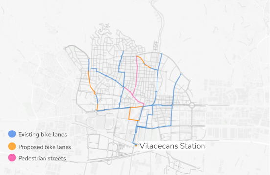
The network adapts to different spatial conditions in different locations and is consequently in three different categories:
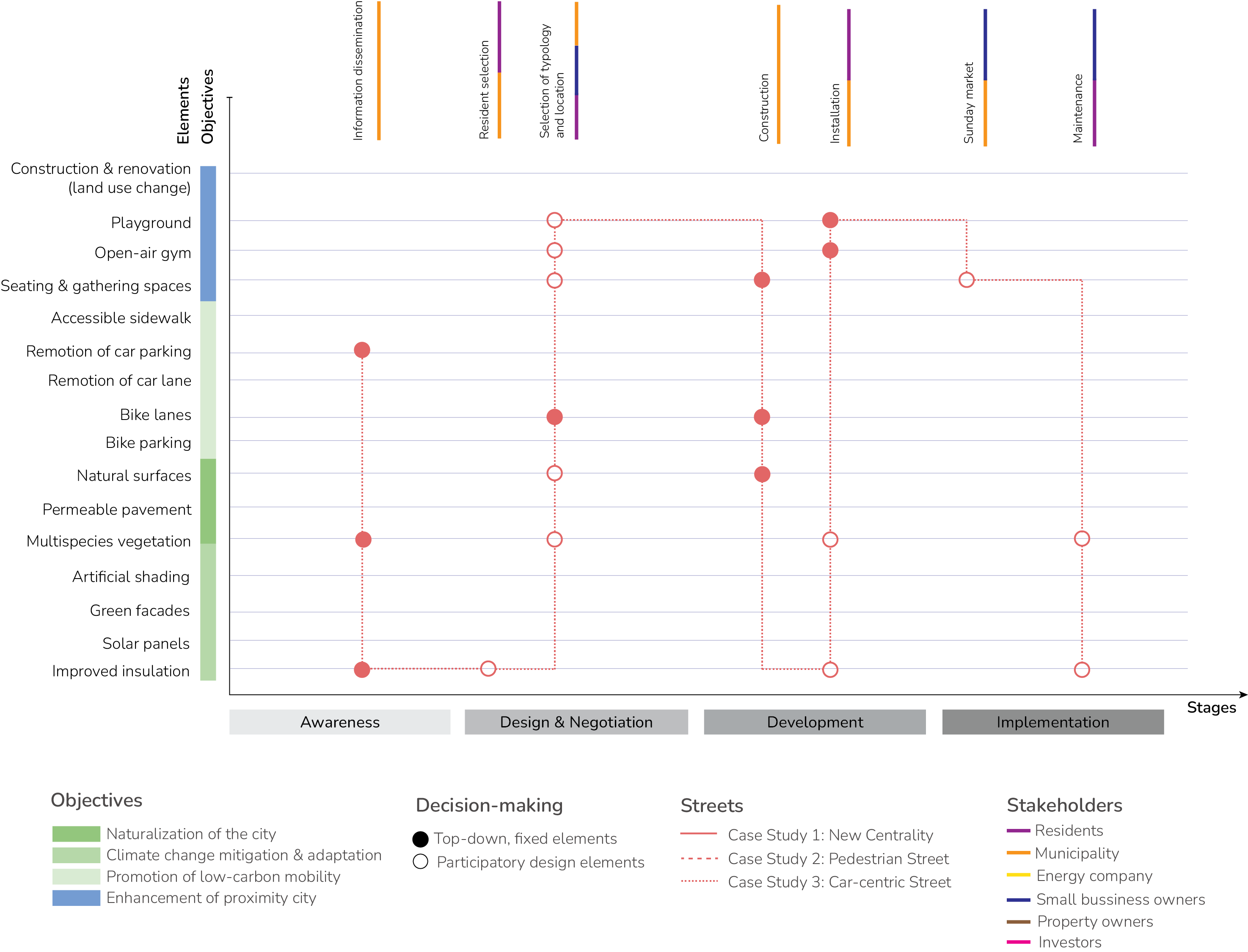
Street Elements design
Bringing the new centrality and climate shelter network to life requires transforming the existing street network. We draw inspiration from Jan Gehl’s concept of “good cities,” where streets prioritize people and offer a variety of social and optional activities beyond just transportation or “necessary” activities.
Following this principle, we identified key services we want our streets to provide, aligning with the project’s initial goals of sustainability, walkability, and community vibrancy. These services then translate into tangible street elements, either newly introduced or modifications of existing features.
Through this approach, we can create streets that cater to a wider range of activities – not just commuting but also leisure, socializing, and fostering a sense of community.
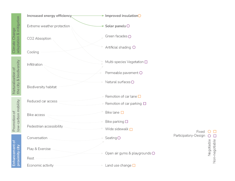
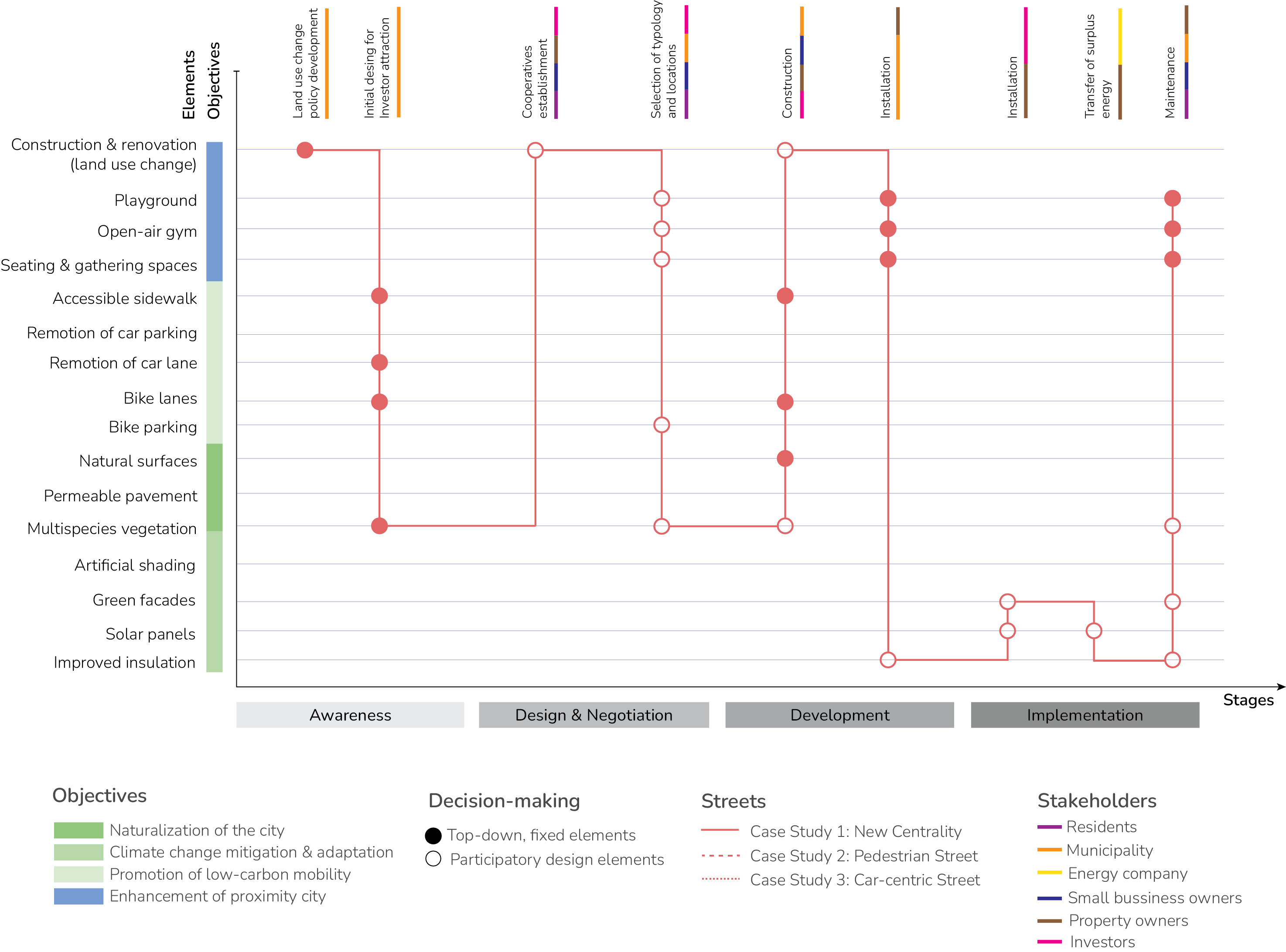
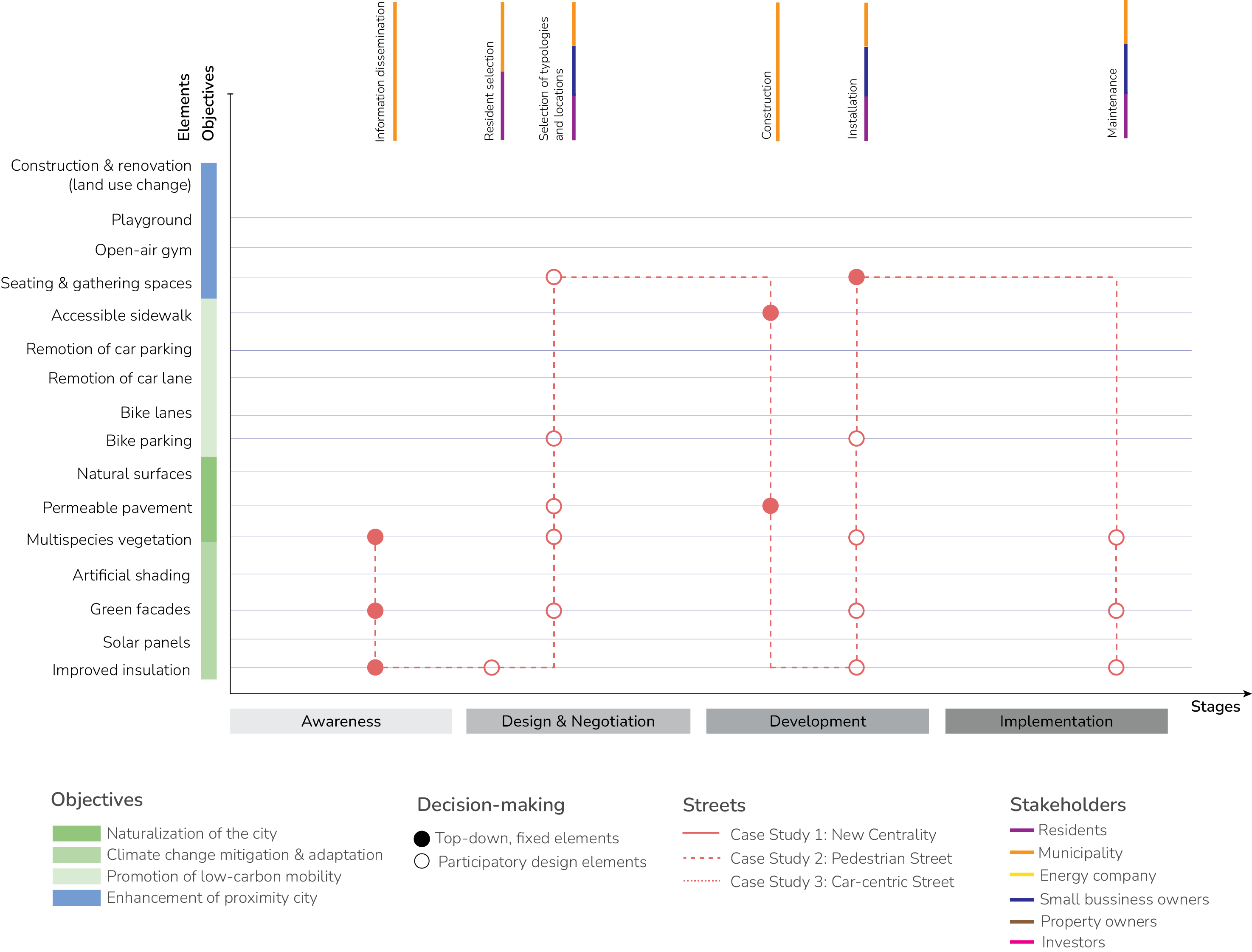
Our design philosophy prioritizes flexibility and community engagement. We recognize that each street within the network has its own unique character and needs. Therefore, the proposed street elements are additionally categorized according to two key factors:
- Optional vs. Non-Optional: This categorizes elements based on their necessity for achieving the project’s core goals. Non-optional elements, like wider sidewalks or bike lanes, are crucial for functionality. Optional elements, such as open-air gyms or community gardens, add vibrancy and cater to specific community needs.
- Fixed vs. Participatory Design: This distinction highlights the level of community involvement. Fixed elements will have a pre-determined design, while participatory design elements will be developed collaboratively with residents. This approach ensures a balance between core functionality and the opportunity for residents to shape their public spaces.
By emphasizing a flexible and bottom-up approach, we aim to create a network of streets that are not only functional but also reflect the unique character and desires of the Viladecans community. The following section will delve deeper into the specific street elements proposed, outlining how these categories will be applied to each element.
Case Studies
The proposed climate shelter network encompasses a variety of streets within Viladecans, each with its unique character and challenges. To demonstrate the project’s adaptability, we’ve selected three case studies for in-depth analysis. These streets represent distinct profiles and needs within the network:
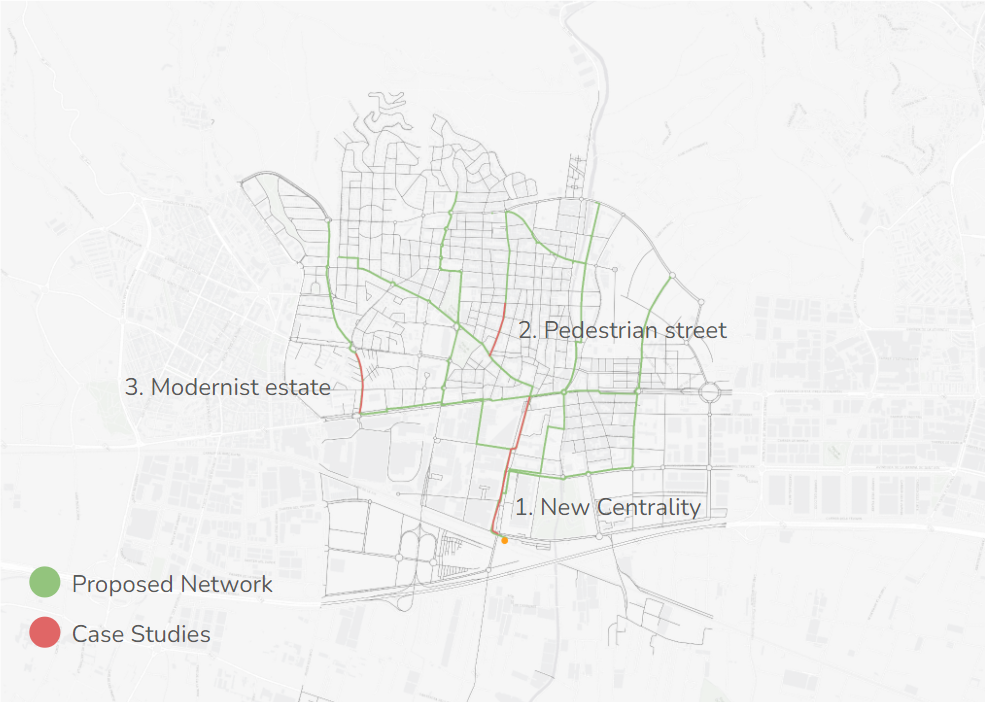
- New Centrality: This street is located in the proposed centrality. Here, the focus will be on reducing car space and repurposing the freed-up land to create new, mixed-use buildings. This creates more space for people to move around, fostering a more vibrant and walkable area.
- Pedestrian Street Corridor: This case study examines a street within the central area that faces economic vulnerability and energy poverty. We’ll explore how design interventions, focusing on facade management, can revitalize this area, not only fostering economic activity and community engagement but also reducing energy consumption for residents and businesses.
- Modernist Estate: This street on the network’s periphery currently prioritizes car traffic. We’ll explore how to transform this space to encourage walking, cycling, and a more balanced use of public space.