OVER THE NEXT FEW DACADES HELSINKI EXPECTS TO ADD AROUND 250.000 NEW RESIDENTS IN 30-40KM OF TRANSFORMED MOTORWAY – LIKE HIGHWAYS
PROJECT DESCRIPTION:
In the future, a transition from highways and roadways to boulevards is anticipated due to a projected decrease in the number of cars. This shift is expected to address several issues commonly associated with highways, particularly in lower-income neighborhoods, such as reduced noise pollution and improved livability. This project aims to develop a data-driven urban model using Python to predict optimal areas and their characteristics for road infrastructure replacement with housing complexes. The methodology involves leveraging geospatial analysis techniques, including classification algorithms and geographic weighted regression (GWR) with the main target to assign variable values to new areas overlapping with former infrastructure.

DATA FORMATTING & STRUCTURING:
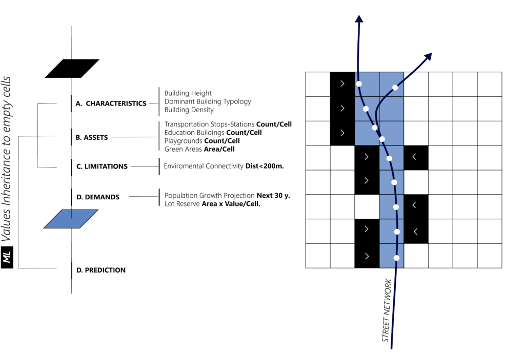
In terms of data aggregation, data will be formatted in cells of 100x100m. Every known cell is described by 4 main entities containing a set of data:
a)Characteristics: Spatial data both is numeric and categorical values describing the dominant urban attributes of each cell. Data as such can be the building height and density as well as the dominant building use, materiality or typology.
b)Assets: Data of quantified urban qualities such as the transportation hubs, public amenities, or the green areas cover per each cell.
c)Demand: This category refers to the population and lot reserve values per cell.

METHODOLOGY:
The Methodology will make use of clustering algorithms in order to define the categorical values for the unknown cells and then spatial regression to assign values to them. The train Dataset will be the whole grid of the city wile the prediction dataset will contain the cells within a buffer around the road. The buffer will include cells that their distance to the road will be less than 800m.

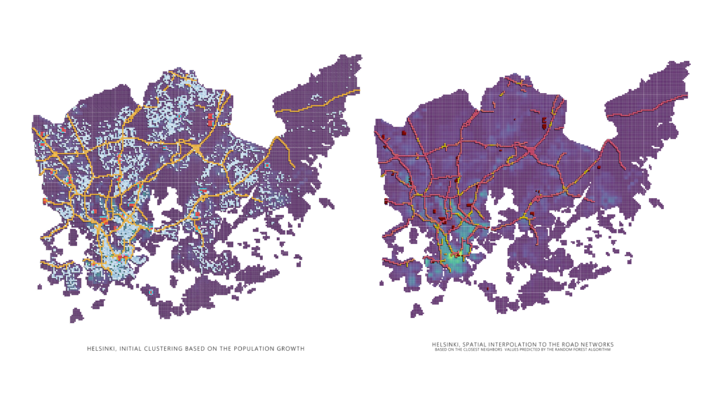
The optimal number of clusters will be selected based on the elbow method. In this case is 3. In our example we will use the elbow method since the number of clusters in this case will simplify the process of this experiment.

In case that more data would be available for this study we could have used more clusters. In this case we are emphasizing in the population growth trend and we will narrow down our features to data related with population and built space density. The clustering map (on the left) , visualizes areas with large potential to be developed and densified in the future near the road network based on the following indicators:
1. Population Density / Cell 2. Number of Houses / Cell 3. The Lot Reserve that the city plans to develop in the next 15 years / Cell 4. The total built floor area/ Cell

In order to prepare the source data for spatial interpolation, we will exclude the cells that are part of the road network to avoid their influence on the interpolation process. The remaining cells will serve as the input data for spatial interpolation.
For our spatial interpolation task, we will utilize the random forest algorithm as an example. The goal is to predict the amount of reserve areas that can be gathered around the areas of the road network. To accomplish this, we need to identify the features and target variable. The features will consist of relevant columns from the dataset that can be used to predict the desired outcome. These features may include environmental, geographical, or demographic attributes, among others. The target variable represents the quantity of reserve areas that can be obtained around each road network cell.

To perform the spatial interpolation, we will employ the trained random forest model. This model will predict the values for the cells located within the road network by considering the values of neighbouring cells. The neighbouring cells, which are not part of the road network, will be used as input to the random forest model for making predictions. By incorporating the values of surrounding cells, the model aims to estimate the potential reserve areas that can be established in proximity to the road network.

