IAAC’s Master in City & Technology (1 or 2-year program) is a unique program oriented towards redefining the analysis, planning, and design of twenty-first-century cities and beyond. The program offers expertise in the design of digitally enhanced, ecological and human-centered urban environments by intersecting the disciplines of urbanism and data science. Taking place in Barcelona, the capital of urbanism, the Master in City & Technology is training the professionals that city administrations, governments, industries, and communities need, to transform the urban environment in the era of big data.


Filters
Course

The Land Remembers

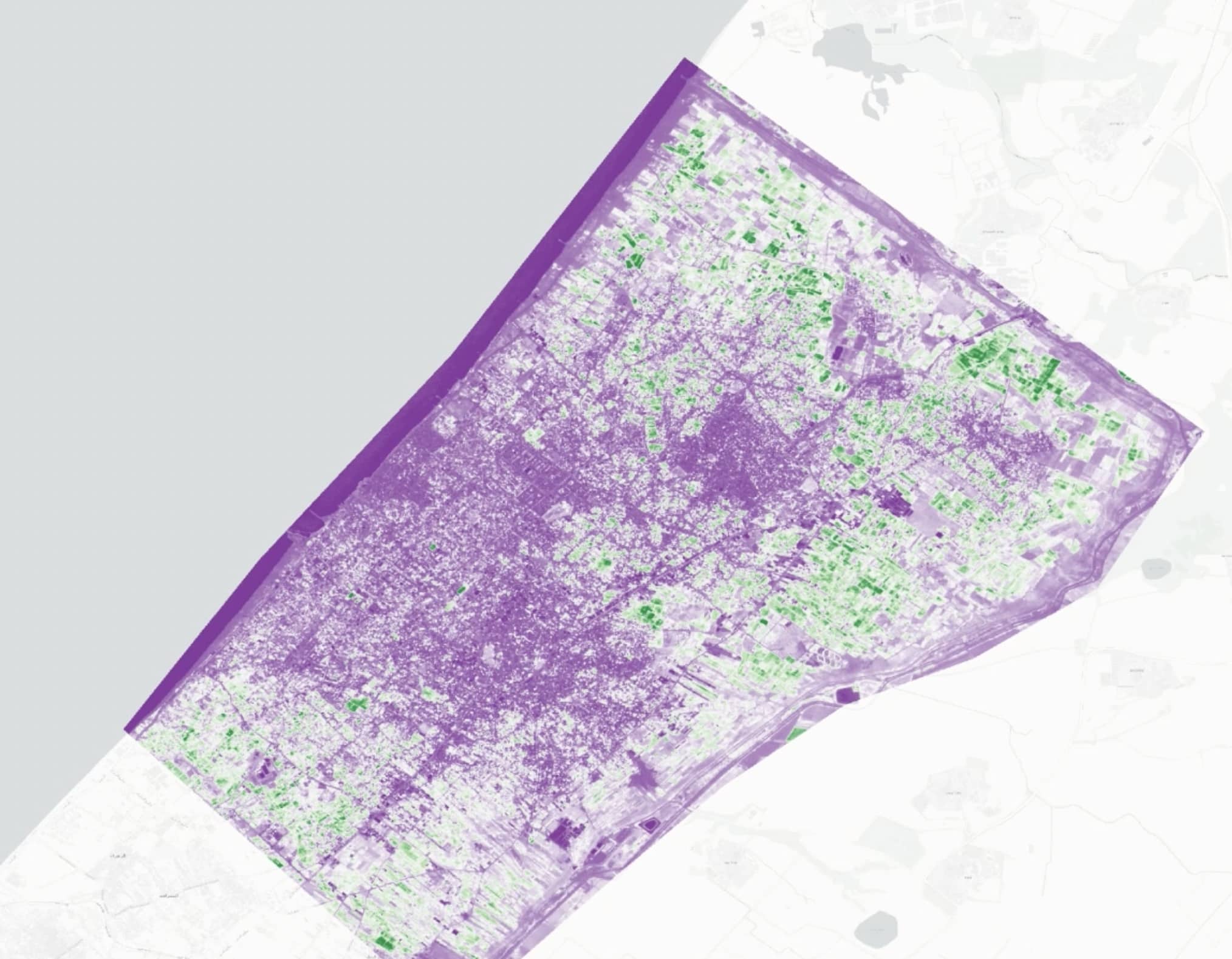
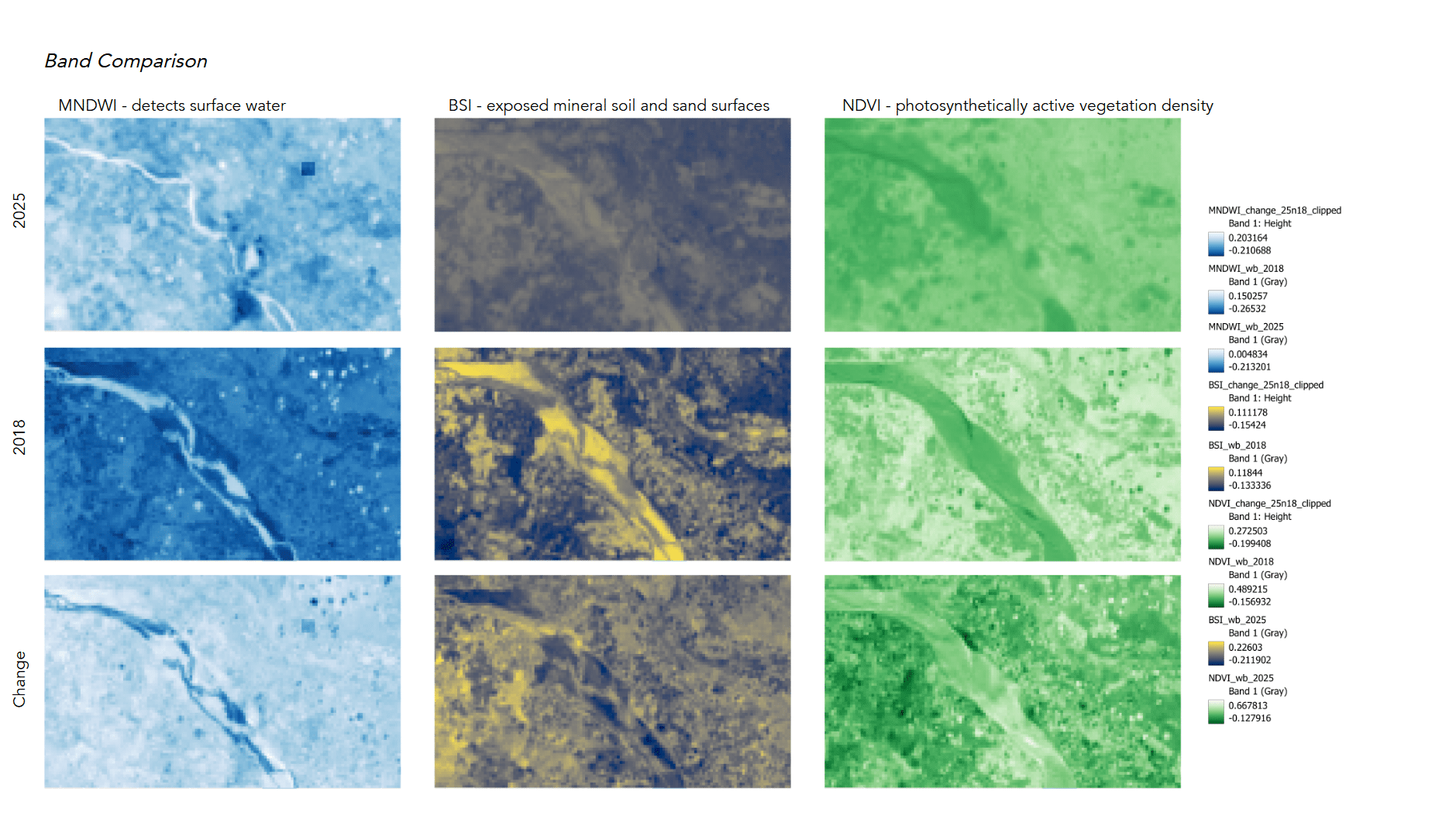
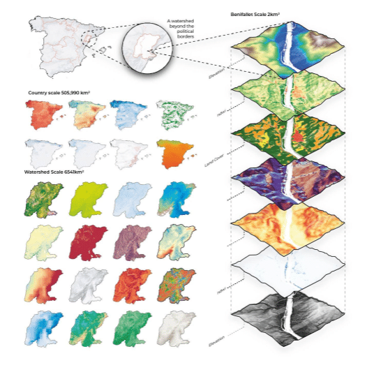
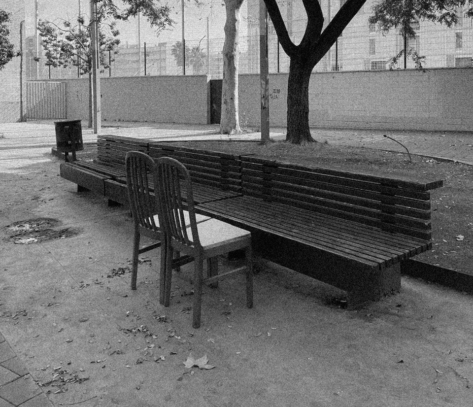
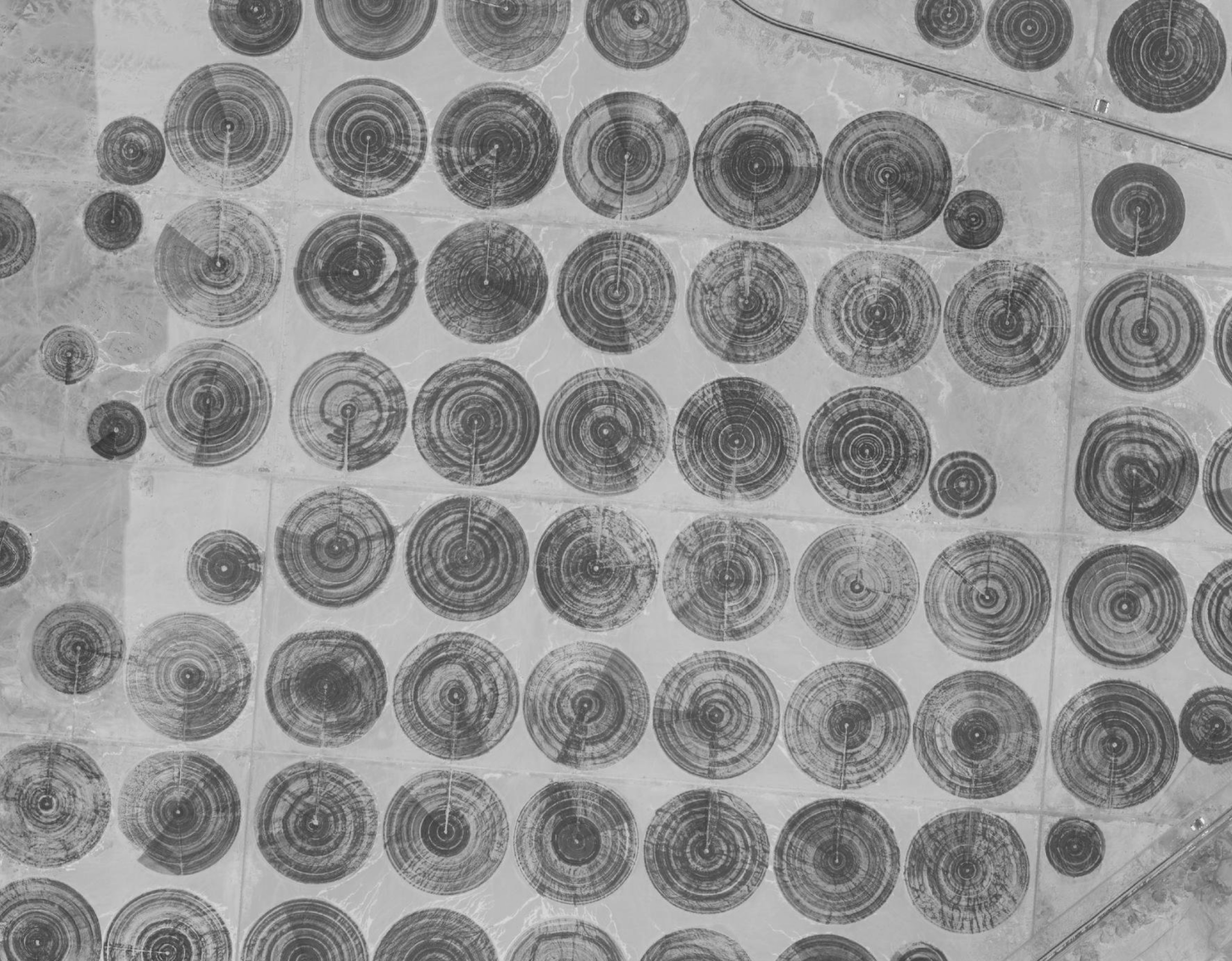
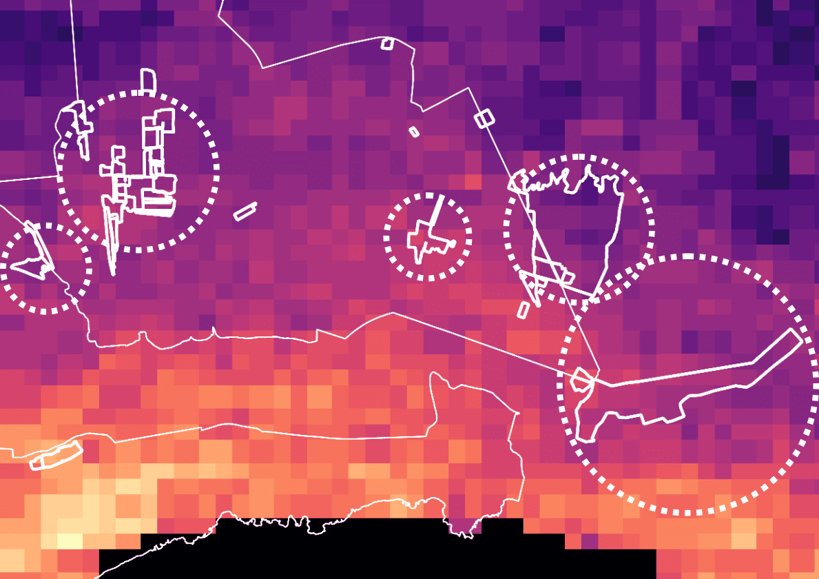
Agricultural landscapes often disappear from visual and political attention during conflict, overshadowed by images of urban destruction. This project uses satellite imagery to examine agricultural land in Gaza, focusing on the Beit Hanoun belt as an intersection between destruction and food systems. Through vegetation indices and bombing crater detection, the study distinguishes seasonal agricultural cycles … Read more

Sand Mining – from Afar

DETECTING SAND MINING USING MULTI-TEMPORAL SATELLITE IMAGERY Introduction Sand is ubiquitous in the modern world. It is the second-most extracted material on Earth after water, driven principally by the global demand for concrete, infrastructure, and urban expansion. Estimates place global sand and gravel extraction at 40–50 billion tonnes per year, a scale that outstrips many … Read more

Agent Based Model: A Way to Visualize Alternative Multispecies Futures, Support Decision-making and Empower Collective Action

This proposal envisions an agent-based ecological simulation where human and non-human actors, farmers, water, soil, plants, fungi, and climate, interact within a shared bioregion defined by watersheds rather than political borders. Agricultural technicians serve as mediators between data and local knowledge. Agents are not merely data points but active participants in a living network, continuously … Read more

Cesium: Visualizing the World in Unity

Creating a Visual Medium for the Visualization of Urban Data Using Cesium in Unity Engine for Geospatial VisualizationCesium for Unity bridges 3D geospatial data with Unity’s real-time development environment, enabling developers to create immersive, real-world simulations and applications. By integrating high-accuracy global datasets, 3D Tiles, and dynamic data feeds, it provides a robust framework for … Read more

VISUALISING VISIBILITY OF WOMEN+ SAFETY

Overview Visualizing Visibility of Women+ Safety is a research initiative aimed at evaluating how the design of public spaces influences perceptions of safety for women+ in India, particularly in Delhi. The central question driving this study is: “How can we assess the current paradigms of urban design to better understand and improve perceptions of safety … Read more

Democratizing Credit: Diving Deeper

City

Diving deeper into building a reliable rating algorithm The Importance & Significance of the F&B establishments in the City Food and Beverage (F&B) service outlets are significant indicators of urban progress as they reflect evolving consumer preferences, economic vitality, and the integration of social spaces within urban landscapes. These establishments act as hubs for community … Read more

Layers of Besòs: Unfolding Barrio’s Identities

Introduction: Understanding Besòs Beyond the Surface The El Besòs i el Maresme area in Barcelona carries a complex history—one shaped by migration, exclusion, and resilience. Often perceived through the lenses of insecurity and economic struggle, the neighborhood is in fact a vibrant intersection of identities, cultures, and urban transformations. Layers of Besòs is a research-driven … Read more

Literary Landscapes &AI-Driven Urban Design

tres tombs

A speculative approach to Design through data, literature, and participatory AI in Sant Antoni Our urban issue: The Lack of Narrative-Driven Urban Design in a Data-Driven City Contemporary urban design increasingly relies on AI and big data, often sidelining human stories, cultural narratives, and historical context in shaping urban spaces. While data-driven design optimizes efficiency, … Read more

Agent-Based Collaborative Design

FETCH.AI Design

Designing an Inclusive and Functional Bench Through the Lens of Iconic Visionaries Urban design has always required balancing complex social, cultural, and environmental factors. In this project, we explored the potential of AI in shaping public spaces. Specifically, designing a bench that serves the needs of both homeless individuals and daily users. We developed a … Read more

Questioning ‘Mixed-Use’ Space

What defines a mixed-use space? How do we visually recognise the coexistence of residential, commercial, and public spaces in a city? Can AI perceive these complex urban conditions as we do? This workshop explores how Visual Language Models (VLMs) interact with urban imagery, using street view images to assess land-use patterns. By comparing Barcelona and … Read more

Stolen River

Unmasking Nile’s Land Grabbed Territories The advanced political economies have shape a world where complexity too often tends to produce elementary brutalities under complex modes of expulsion. Most of the time those dynamics operate at a more subterranean level. The tools driving this phenomenon range from basic policies to complex institutions, systems, and techniques that demand … Read more

Informal Settlements in Chile

Informal settlements have become a pressing issue across Latin America, reflecting deep-rooted socioeconomic inequalities and rapid urbanization. In 2014, approximately one-quarter of the urban population in Latin American cities lived in informal housing. By 2017, this number had increased to nearly one-third, and the trend continues to rise. Each country’s informal settlements have unique names … Read more

Apps4Citizens

logo

Barcelona, like many modern cities, experiences the Urban Heat Island (UHI) effect, where built-up areas retain more heat than surrounding natural landscapes. This interactive map visualizes temperature variations across the city, highlighting areas most affected by heat buildup. 🛰️ What This Map Shows: 📍 Heat Hotspots – Areas with high surface temperatures due to dense construction and limited … Read more

Places to stay

Viladecans greeted us with an unexpected tranquility. We arrived to the city on the commuter train from Barcelona, opposing the flow of morning commuters. The station was empty. A single street, lined with abandoned plots and industrial sheds led us up the hill into the town. A few hundred metres later the scene couldn’t be … Read more