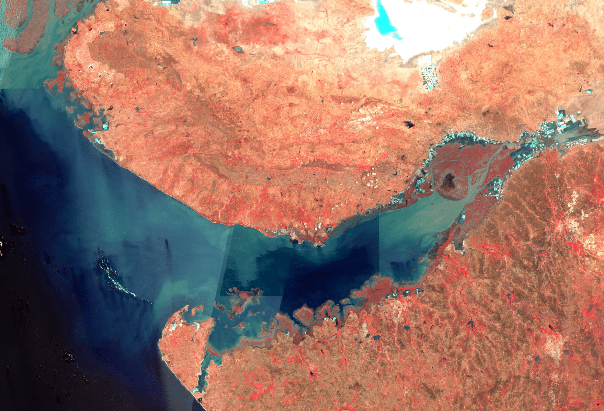
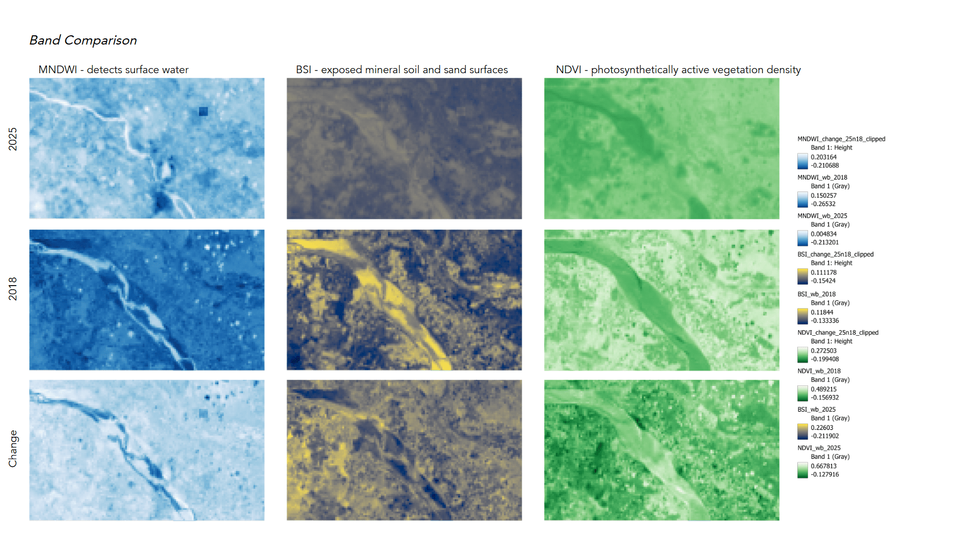
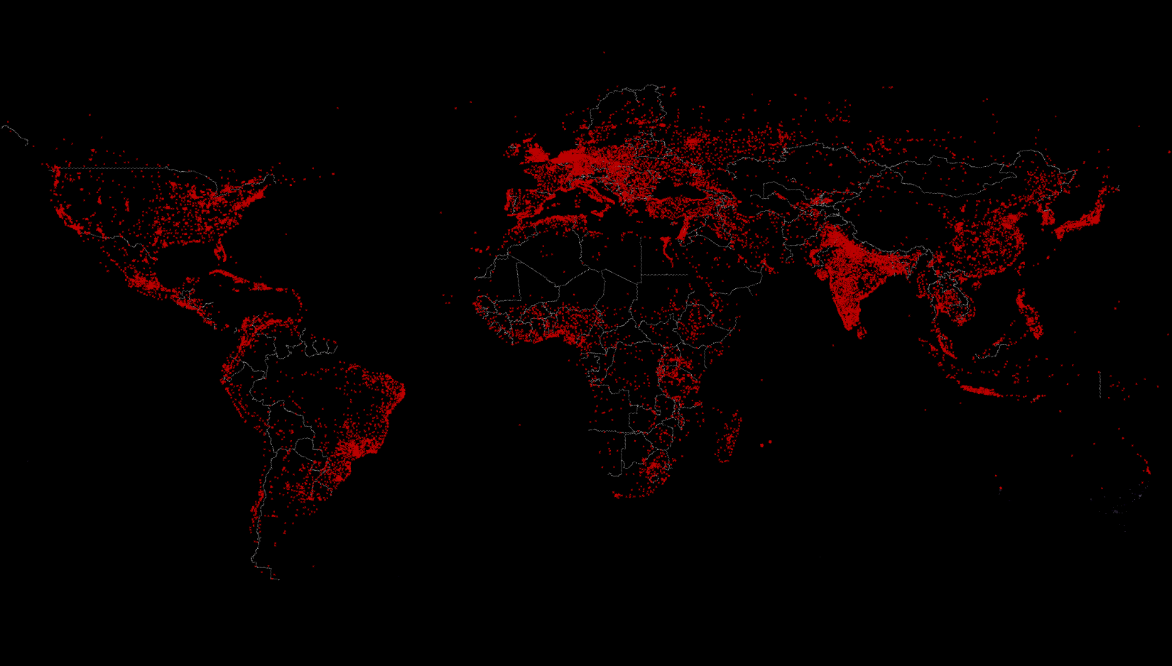
IAAC’s Master in City & Technology (1 or 2-year program) is a unique program oriented towards redefining the analysis, planning, and design of twenty-first-century cities and beyond. The program offers expertise in the design of digitally enhanced, ecological and human-centered urban environments by intersecting the disciplines of urbanism and data science. Taking place in Barcelona, the capital of urbanism, the Master in City & Technology is training the professionals that city administrations, governments, industries, and communities need, to transform the urban environment in the era of big data.


Filters
Course

SAND MATTERS

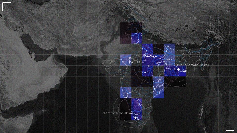
– A satellite based platform for detecting sand mining across India Sand is the most extracted solid material on Earth, yet it remains one of the least regulated. In India, where rapid urbanisation drives relentless construction demand, river sand extraction has escalated into a crisis of ecological damage, governance failure, and organised crime. Riverbeds are … Read more

Ciutat Nova Franca

Barcelona is a city that faces many physical limitations to it’s expansion as a metropolis-the mountains contain development within them and the sea borders its other side. For the past 15 years, it has been struggling with an immense wave of tourism that has displaced locals from affordable housing in popular areas and historic neighborhoods … Read more

Reconnecting the Port

Satellite imagery of Barcelona with words in black "Reconnecting the Port"

Re-envisioning Container City One of Barcelona’s most strategically located waterfront areas, the container port south of Montjuïc, remains largely disconnected from the inner city. As the city explores the possibility of relocating portions of its container operations in this speculative project and transforming this industrial landscape into a mixed-use district, mobility becomes a more pertinent … Read more

WING IT – Microclimatic Corridor For Non Humans

Microclimatic Corridor is a proposal for the transformation of Carrer de Rocafort into a climate shelter for non-human urban life. Responding to rising temperatures, biodiversity decline, and the urban heat island effect in Barcelona, the project extends the ecological and microclimatic performance of Jardins de Montserrat into the surrounding street network Climate change as a … Read more

The Land Remembers

Agricultural landscapes often disappear from visual and political attention during conflict, overshadowed by images of urban destruction. This project uses satellite imagery to examine agricultural land in Gaza, focusing on the Beit Hanoun belt as an intersection between destruction and food systems. Through vegetation indices and bombing crater detection, the study distinguishes seasonal agricultural cycles … Read more

The Agariyas of Gujarat

Salt is an essential mineral for humans and animals alike. When consumed, it breaks down into sodium and chloride – elements vital to muscle and nerve function, fluid balance, and the regulation of blood pressure and pH levels. Because sodium is lost through sweat, both humans and animals must replenish it to maintain physiological stability; … Read more

Sand Mining – from Afar

DETECTING SAND MINING USING MULTI-TEMPORAL SATELLITE IMAGERY Introduction Sand is ubiquitous in the modern world. It is the second-most extracted material on Earth after water, driven principally by the global demand for concrete, infrastructure, and urban expansion. Estimates place global sand and gravel extraction at 40–50 billion tonnes per year, a scale that outstrips many … Read more

The Wooded Circle

Started off in 1504 as a Renaissance-era fortification system, designed to resist cannon warfare. Over the years, it has undergone many reconstructions, with the latest turning it into a managed heritage park in the early 2000s (Planted rows of trees) . Ecology has played an important role in each of its eras, as we’ll see … Read more

Who else lives here?

Urban space is conventionally conceptualized as an anthropocentric construct. However, non-human species continuously appropriate architectural surfaces, infrastructural voids, and vegetated fragments. Birds occupy ledges and canopy layers, insects colonize engineered soils, bats navigate nocturnal corridors along tree lines, and plants root within pavement fissures. These presences are not incidental; they reflect how spatial design either … Read more

How does Power operate spatially in Poblenou?

This project explores how power operates spatially through counter-cartography and autoethnography in Poblenou, Barcelona. Combining observation, mapping, and self-tracking, the research examines how infrastructure, urban objects, rules, and rhythms shape behavior, movement, and perception. Benches, pedestrian streets, and smoking practices reveal how freedom, restriction, and permission are unevenly distributed. Findings show that movement is widely … Read more

Poblenou as Lived Space

Cities are often described in terms of movement. We often tend to move through them in familiar loops – leaving home to catch the metro, commuting to work, coming back in the evening, running errands, going to appointments. Over time, these repeated paths shape how we think about urban space and can seem to define … Read more

Make the Vulnerable, Less Vulnerable

Brazil Vulnerability Cartography Brazil, a vast and vibrant country, is renowned for its breathtaking landscapes from rolling highlands to expansive savannas. It’s known for iconic beaches and bustling urban centers where a dynamic blend of cultures and ethnicities come together. Its cities hum with energy, music, and art. Together, these diverse landscapes and rich social … Read more

Longevity Landscapes

Mapping Proximity to Wellbeing Amenities in Urban Areas “For most of us from now on, life and death will be an urban affair.”— World Health Organization As cities become the primary environments in which people age, longevity can no longer be understood as a rural or lifestyle-driven phenomenon alone. Inspired by — but critical of … Read more

Cities on the Edge

How borders shape frontiers of urban life? I. Introduction Borders are often perceived as abstract lines on maps, yet they deeply shape how cities grow, connect, and fragment. Cities located along international borders experience unique spatial, social, and political conditions that distinguish them from inland urban areas. This project investigates borders not as static lines, … Read more