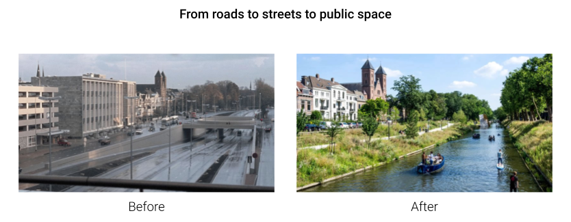
The motorway was the symbol of progress during the modern age. The car was the central element of the American dream, and then expanded across the globe, transforming the way we live. Over the years, it has become clear that individual conventional cars are not only good for cities: urban motorways often create physical and socio-economic barriers within cities, contribute to pollution, take up valuable space, and divide communities. Many local governments are now looking to downgrade or remove old car-based infrastructure to gradually transform main roads into streets and, eventually, public spaces. As it can be hard to gauge the consequences of those large changes and identify the best opportunities within the traffic network, the project aims to propose a methodology that can help policymakers prioritize which roads to transform.
Methodology
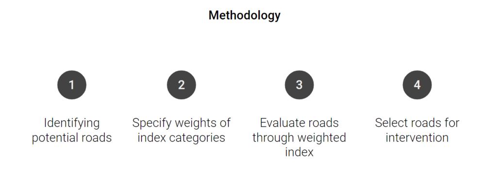
The methodology for identifying and prioritizing roads for repurposing involves several steps:
- Identifying Potential Roads: Assessing motorways suitable for transformation.
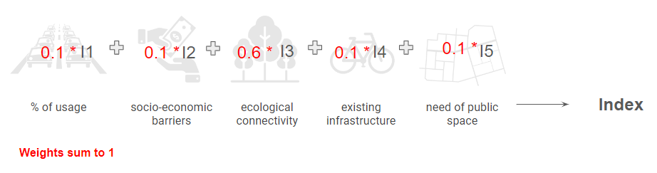
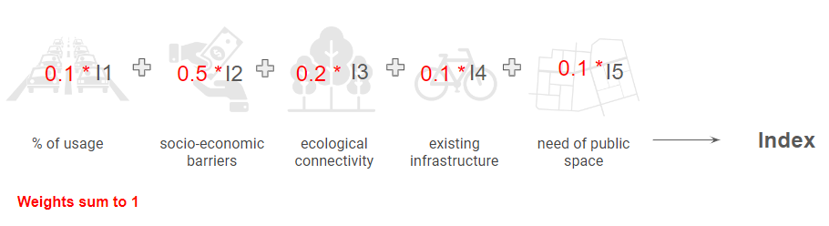
- Specifying Weights for Index Categories: Determining the importance of various factors such as usage, socio-economic barriers, ecological connectivity, existing infrastructure, and the need for public space.
- Evaluating Roads: Using a weighted index to evaluate the potential impact and feasibility of repurposing each road.
- Selecting Roads for Intervention: Prioritizing roads based on their scores from the evaluation process.
Evaluation Factors
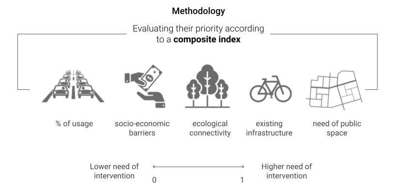
- Usage: Assessing traffic flow and capacity utilization. Would the transport system break down if this road was removed or is the system flexible enough to cater for the required trips anyway?
- Socio-Economic Barriers: To what extent does the road create socio-economic divisions within the community? The divisions can be represented, for example, as life expectancy difference and income difference.
- Ecological Connectivity: Determining the potential to connect green spaces. Would the transformation of the road make possible the reconnection of ecological habitats, providing a more robust ecological system?
- Existing Infrastructure: Evaluating the presence of current infrastructure that could support the transition. Are there alternative transport systems in place that could ease the pressure on the road network?
- Need for Public Space: Measuring the current availability of public spaces in the area. What percentage of the land use is dedicated to public space?
All these factors are proposed to be evaluated in a range from 0 to 1, 0 representing no urgency in transformation and 1 referring to the most critical conditions.
Weights of the indexes
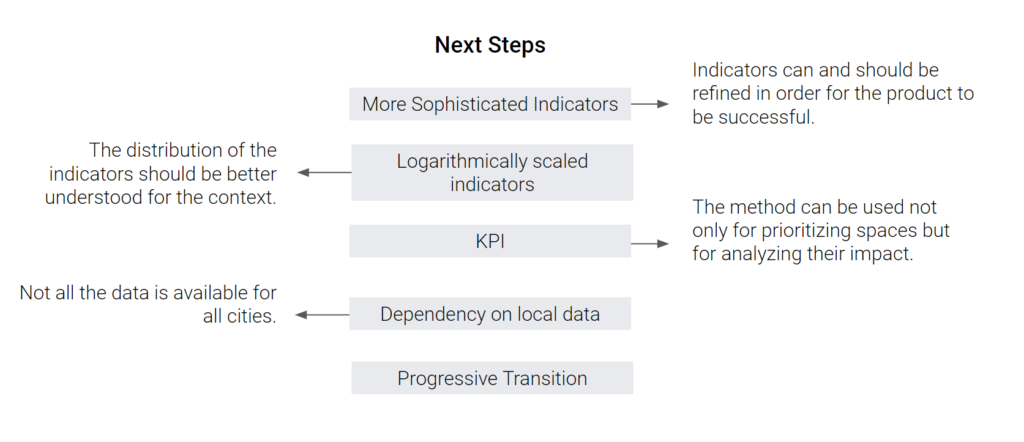
The weights assigned to these factors depend on the primary goal of the transformation. For instance, if the priority is enhancing ecological connectivity, more weight is given to factors like ecological connectivity and the need for public space. Conversely, if the focus is on reducing socio-economic barriers, those specific factors receive higher weights. This flexible index is crucial as it allows for adaptation to various cities and scenarios, ensuring the methodology remains relevant and effective across different urban contexts.
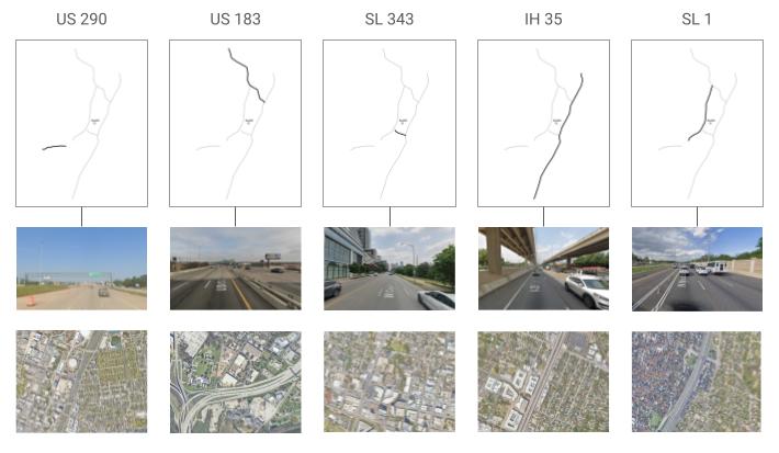
Case Study
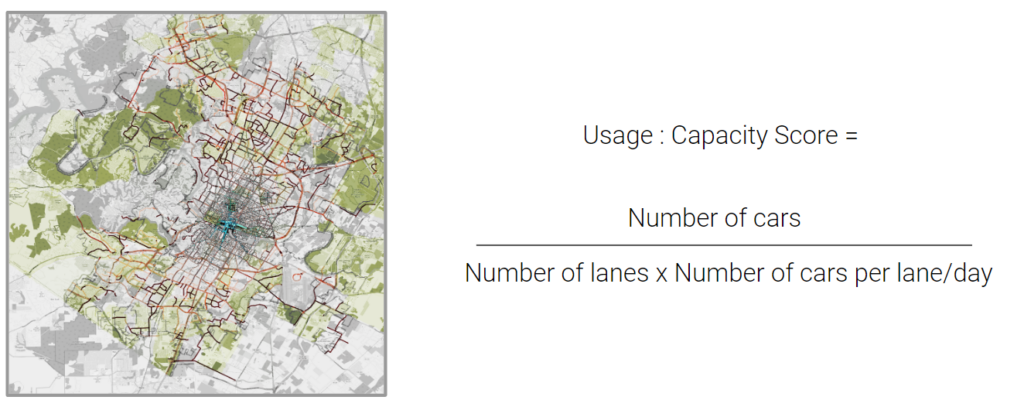
The methodology was applied to a case study in Austin, Texas, focusing on several key roads: US 290, US 183, SL 343, IH 35, and SL 1. Various indicators such as traffic density, socio-economic disparities, and ecological connectivity were used to assess these roads.
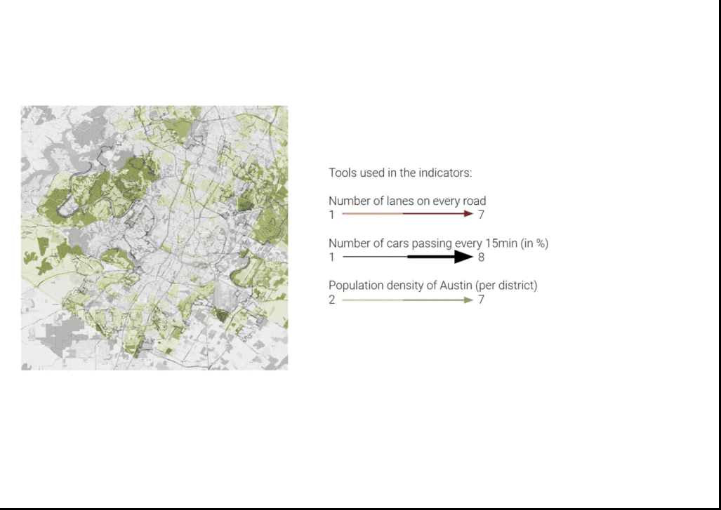
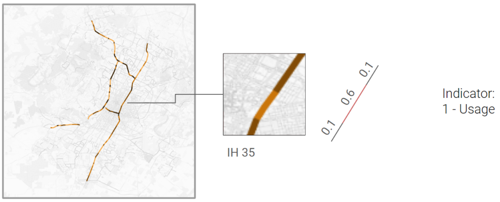
Usage
For the usage and capacity, we identify parts of the selected roads and obtain data from the open data portals of Austin and overlay layers of information to analyse which roads or parts of the road has higher capacity in terms of numbers of lanes and how many cars pass by that certain junction every 15 minutes to then score them by using a formula and then have an average of every variation on the road to get an overall score.
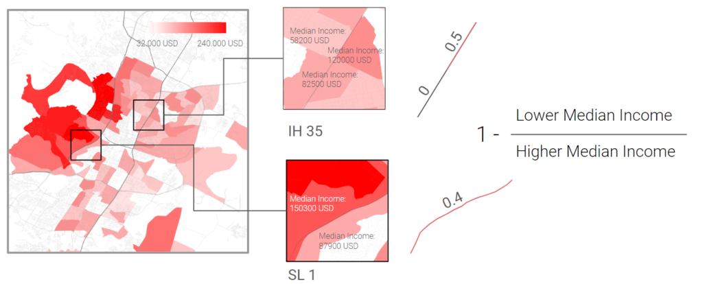
Socio-Economic Barriers
For the socioeconomic barriers evaluation, we obtained data from the U.S. Census Bureau regarding median income levels. We analyzed different portions of each street to compare the median income on both sides. By calculating the ratio of lower to higher income, we were able to assess the socioeconomic disparity across the areas. A ratio closer to 1 indicates greater similarity in income levels, suggesting fewer socio-economic barriers between the two sides of the street. However, due to limitations in the available data, we could not gather information for all areas of the city. Consequently, we focused our evaluation on certain roads and spaces where data was accessible. This approach provided insight into the socio-economic impacts of specific urban areas, even though a comprehensive city-wide analysis was not possible.
Ecological Connectivity
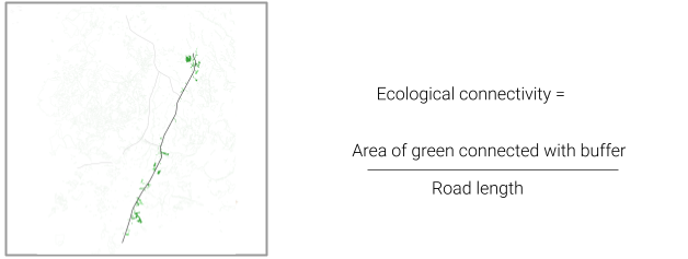
For ecological connectivity we identified the parks and forests from the OSM dataset located within a buffer area of 500 meters from the roads. By summing their area and dividing by the length of the road we obtained an indicator that shows how much green the road could potentially connect. A more sophisticated approach that we would explore in a next step would be to consider the connectivity of the of ecological structures on a regional scale based on land cover data. This would show the role that the transformation of a road could play in the larger ecological system.
Existing Infrastructure
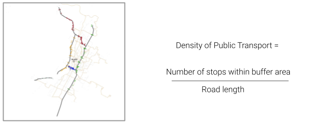
For alternative transport we looked at the density of public transport stops in located in a buffer zone around the selected roads and again divided this by road length. This time we used the capital metro GIS dataset from the Texas state open database (which contains all modes of public transport).
Need for Public Space
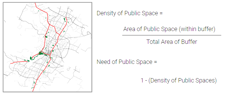
To rank the needs for public space, we looked at the density of public spaces within a buffer from the selected motorway and scored that density by normalising between 0 to 1, with 0 being no need for a public space and 1 being an absolutely urgent need..
Results
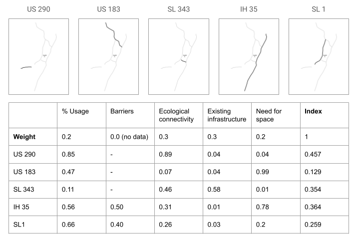
For the final evaluation of our case study, we assigned the following weights to the factors: 0.2 for usage, 0 for socio-economic barriers (due to insufficient information), 0.2 for the need for space, and 0.3 for the remaining factors. These weights reflect the priorities identified in the study, emphasizing ecological connectivity and existing infrastructure as critical components for successful transformation. The most important road identified in our evaluation is US 290. This road scored highly in terms of ecological connectivity and the potential for repurposing existing infrastructure, making it a prime candidate for transformation into a green urban space.
Next Steps