
Introduction: Shorter & Sharper Events
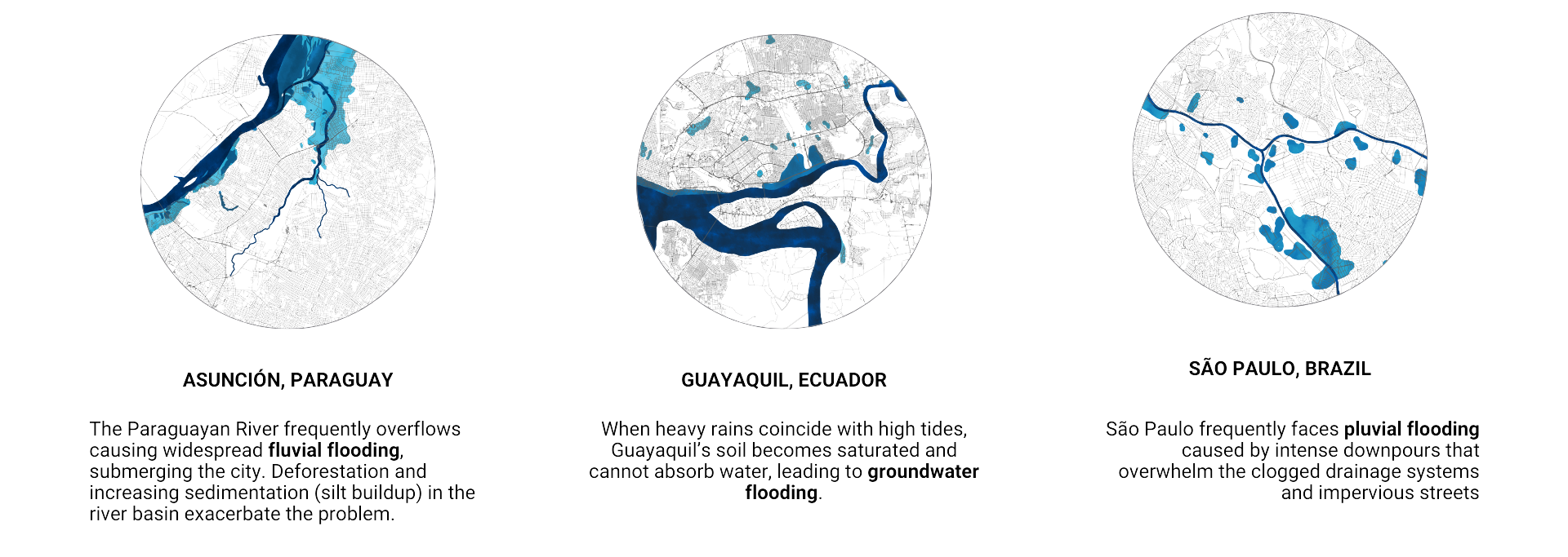
Imagine the persistent drumming of rain against your window. Not the comforting tapping of a spring shower, but a relentless torrent that seems to prolong for days. This isn’t science fiction, but a glimpse into the potential future of many Latin American cities. A staggering 40% of the region is already at risk of flooding1, a harsh reality currently faced by metropolises like São Paulo (pluvial floods), Asunción (fluvial floods), and Guayaquil (groundwater floods).
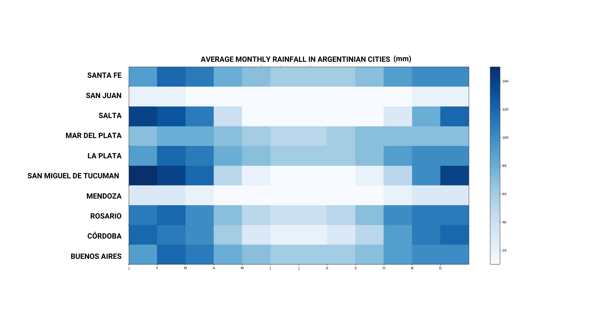
Now, take a look at the graph you have for Argentina’s rainfall patterns. Notice how the precipitation seems to concentrate heavily at the beginning and end of the year, leaving the rest of the months relatively dry. Climate change is projected to intensify these extremes – heavier rain during the wet season, followed by longer, harsher droughts.
This scenario, though seemingly fictional, is exactly what our project explores. We delve into the case of Rosario, Argentina, under an extreme weather event – intense and prolonged rainfall – to see how it would cope. But the purpose isn’t just to paint a scary picture. We’re using this as a springboard to identify existing urban planning and architectural tools that might become obsolete in the face of a changing climate.
Rosario: A city on the edge
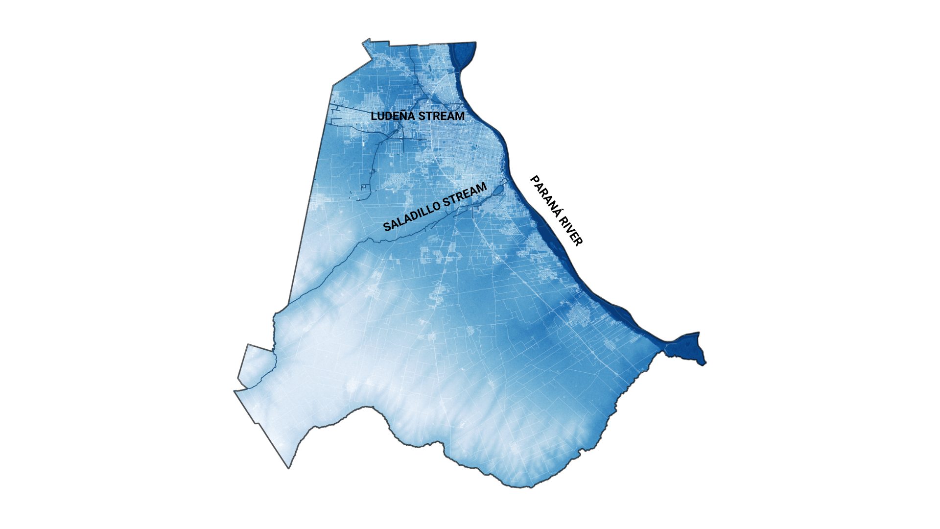
Let’s shift our focus to Rosario, Argentina, a lively city with a population nearing 1 million. Unlike some of its neighbors, Rosario enjoys a slightly higher elevation relative to the powerful Paraná River. This fortunate geography has historically spared it from the worst of the river’s overflows. However, the city isn’t without its own flooding woes. While Rosario avoids major riverine flooding, heavy downpours can overwhelm drainage systems, leading to pluvial flooding. The normally calm streams that crisscross the city, like the Saladillo and Ludueña, can turn into raging torrents during intense rain events, further contributing to urban flooding issues.
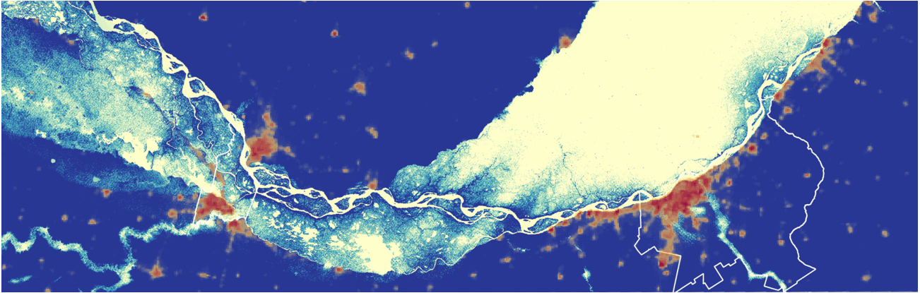
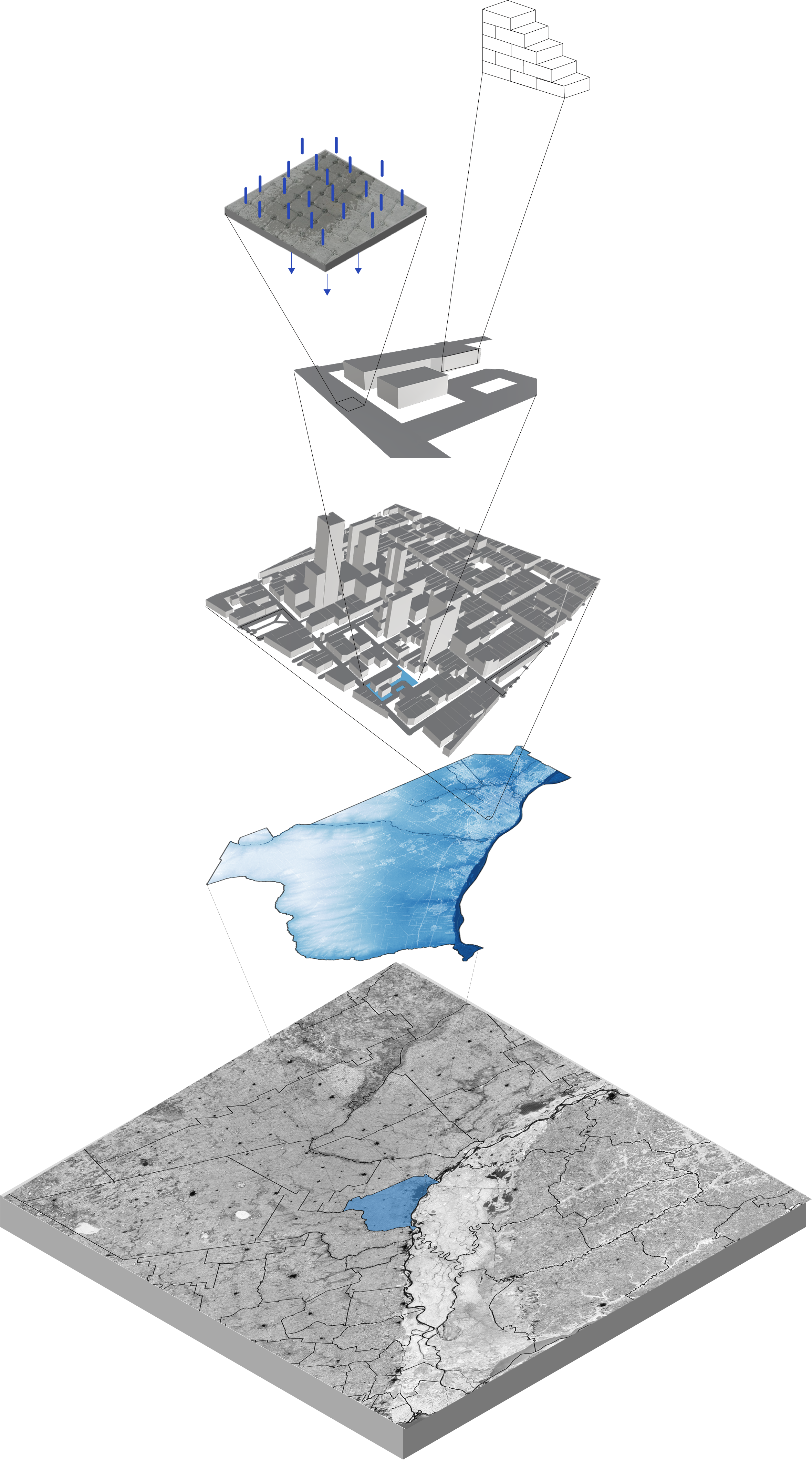
To have a deeper understanding of the existing conditions in Rosario, flood detection strategies and seasonal rainfall were analyzed. The analytical process focuses on flood detection in Rosario, Argentina, by using Google Earth Engine to process Sentinel-1 imagery across a span from 2015 to 2021. The use of Sentinel-1 GRD data, esteemed for surface water detection, incorporates a series of speckle filtering to accentuate aquatic signatures. This operation calculates a fine representation of flood-stricken regions. The resulting data serves as information for intricate environmental assessments.
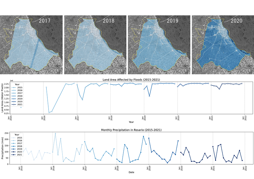
The data illustrates a discernible pattern of seasonal rainfall peaks in Rosario, potentially coinciding with summer months. Notably, there’s a clear correlation between periods of intense precipitation and the incidence of floods. While the annual changes in flood extent suggest a direct link to rainfall, the data also hints at the influence of broader climatic factors contributing to the year-on-year variability observed in the flooding patterns.
Future Scenarios: Torrents of Change
As climate change intensifies, rain events in Rosario might position it in a curious position. While surrounding areas, like the lower-lying Buenos Aires could face even greater challenges, Rosario might become a relatively safe haven. This potential for in-migration adds another layer of complexity to the city’s flood risk equation.
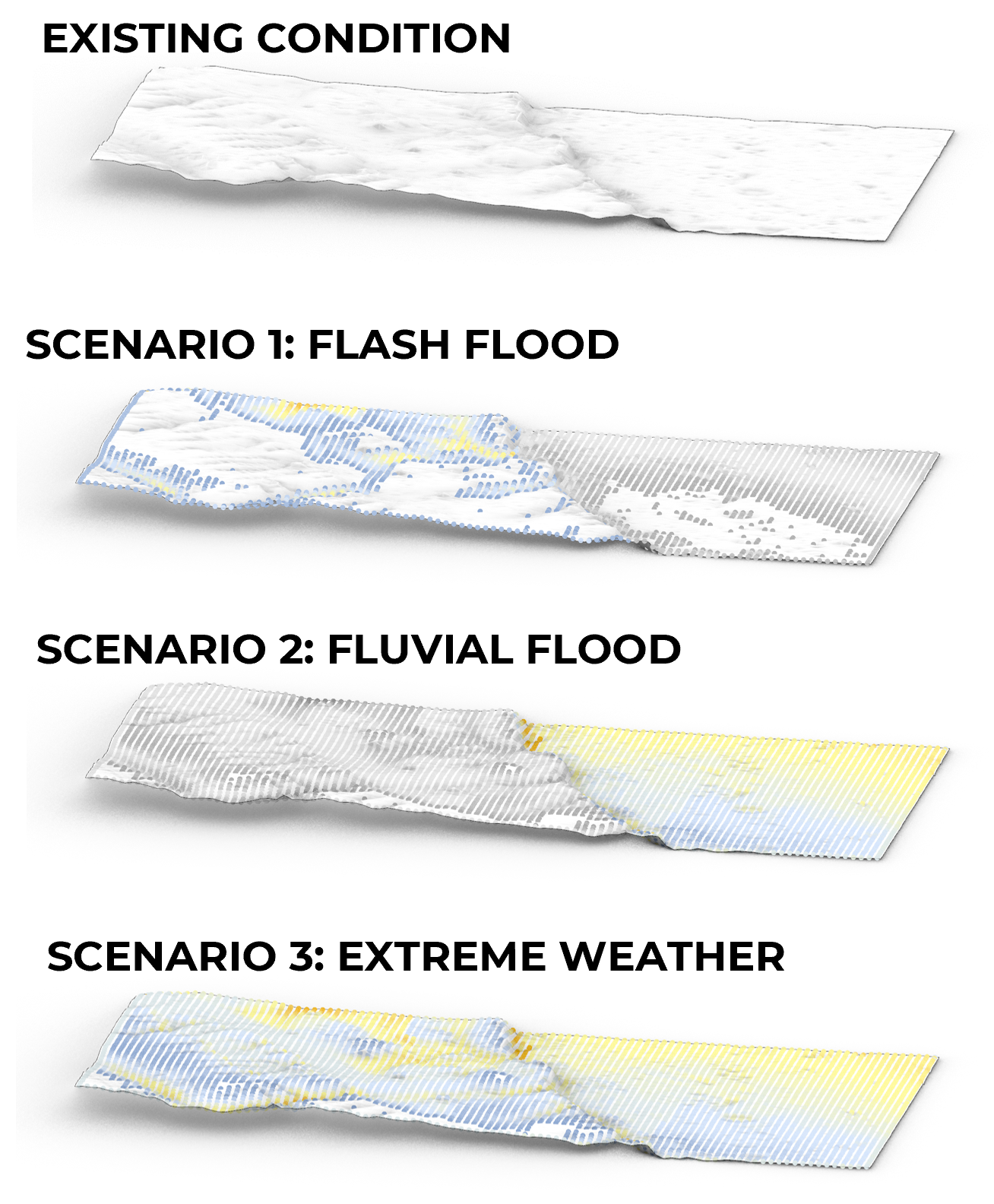
However, extreme weather events such as prolonged storms can indeed lead to disastrous flooding scenarios, especially in low-lying areas. When stormwater accumulates due to heavy rainfall, it can overwhelm drainage systems and cause flash flooding in urban spaces. Additionally, rivers may exceed their maximum capacity during such events, leading to fluvial flooding that can breach protective barriers and inundate surrounding regions.
Efforts to mitigate these risks often involve improving drainage systems, implementing flood control measures, and developing early warning systems to alert residents and authorities about impending flood events. However, despite these efforts, extreme weather events can still pose significant challenges and necessitate ongoing adaptation and resilience-building efforts in vulnerable regions.
To understand the specific areas most vulnerable within Rosario, we employed Grasshopper simulations analyzing the city’s terrain to pinpoint the low-lying pockets most at risk of accumulating floodwaters. This fine-grained understanding is crucial for developing targeted mitigation strategies.
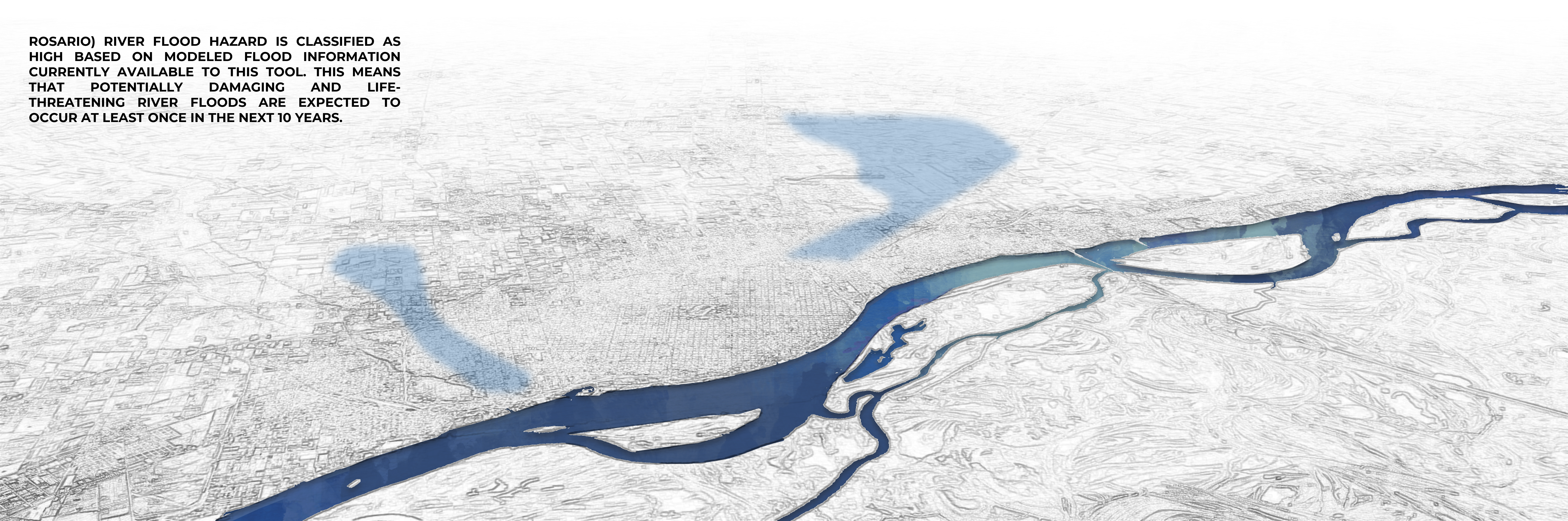
According to the flood modeling data currently accessible, the river flood hazard in Rosario is classified as high. This designation indicates that there is a significant risk of potentially damaging and life-threatening river floods occurring at least once within the next decade. Residents and authorities should remain vigilant and prepared for such events, as they pose a considerable threat to the safety and infrastructure of the area. It underscores the importance of implementing robust mitigation measures and emergency preparedness plans to minimize the impact of future flooding disasters.
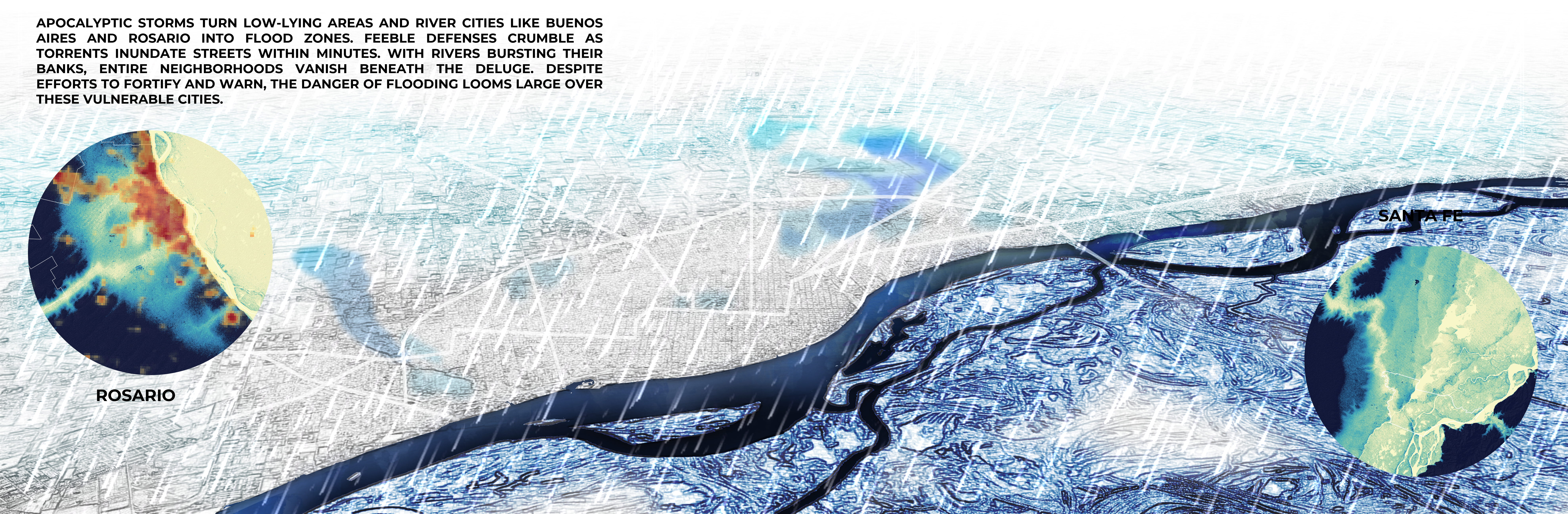
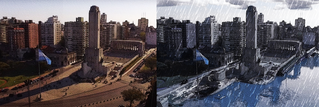
Apocalyptic storms unleash havoc upon low-lying regions and river cities like Buenos Aires and Rosario, transforming them into inundated flood zones. Feeble defenses are no match for the torrents of water that inundate streets within mere minutes. As rivers burst their banks, entire neighborhoods are swallowed by the deluge, leaving destruction in their wake. Despite efforts to fortify defenses and issue warnings, the specter of flooding casts a dark and ominous shadow over these vulnerable cities, perpetuating the imminent danger and uncertainty that looms large.
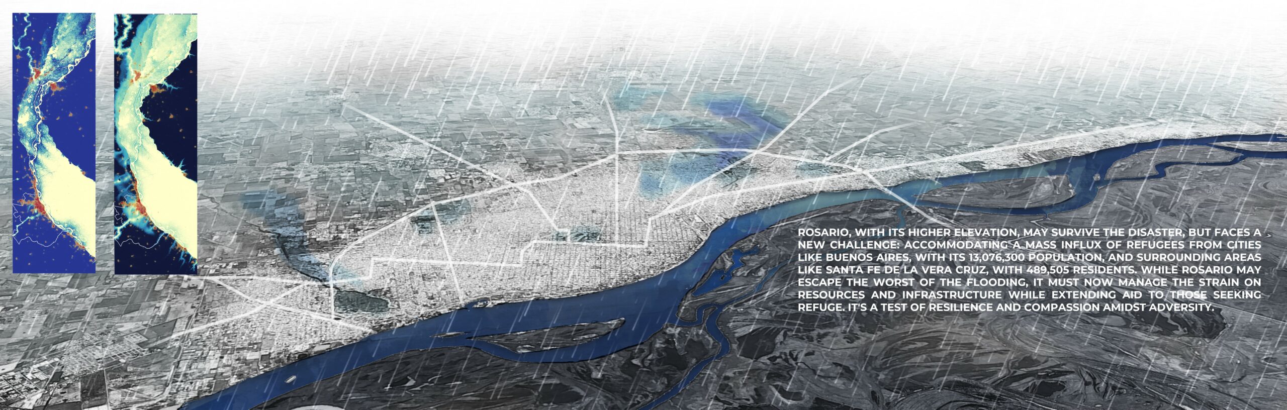
With its higher elevation, Rosario might endure the disaster, yet it confronts a new ordeal: accommodating a massive influx of refugees from populous cities like Buenos Aires, boasting a population of 13,076,300, and surrounding areas like Santa Fe de la Vera Cruz, home to 489,505 residents. While Rosario may evade the brunt of the flooding, it must grapple with the strain on resources and infrastructure while providing assistance to those in need. This situation tests the city’s resilience and compassion amidst adversity, requiring strategic management to navigate the challenges ahead.
A Multi-Scale Approach: Rethinking Urban Planning
Understanding Rosario’s vulnerability is just the first step. We wanted to go beyond simply identifying risks and re-evaluate the tools used for urban planning in the face of this new climatic reality. Therefore, we evaluated different scales, finally questioning urban planning tools at each level:
- Regional Scale: Unfragmented Planning? Historically, cities have been planned in isolation. Can we move towards a more unified regional vision, strategically densifying areas less prone to flooding while considering potential migration patterns?
- City Scale: Strategic Public Space? While parks are essential, are we prioritizing aesthetics over functionality? Should we be designing multi-functional public spaces that can double as shelters on high ground during extreme weather events?
- Neighborhood Scale: De-Centralized Grids? Our current reliance on centralized infrastructure creates vulnerabilities. Can we explore de-centralized models with neighborhoods equipped with localized resources and emergency preparedness plans?
- Street Scale: Nature Collaborations? Traditional, impermeable streets exacerbate flooding. Can we transition to permeable pavements and embrace “sponge city” solutions that mimic natural water management systems?
- Building Scale: Homes for All? Unequal building codes disproportionately affect low-income communities. Can we advocate for affordable, resilient building materials accessible to all, alongside flexible codes that empower flood-resistant construction?
By posing these questions, we hope to ignite a vital conversation. The future of our cities depends on our ability to adapt urban planning to a more volatile climate. Let this be the beginning of a collaborative effort to create resilient, thriving urban centers in a changing world.
In conclusion, Rosario, with its higher elevation, may survive the disaster, but faces the significant challenge of accommodating a mass influx of refugees from heavily populated areas like Buenos Aires and surrounding regions. While it may escape the worst of the flooding, managing the strain on resources and infrastructure while extending aid to those seeking refuge is crucial. This situation tests the city’s resilience and compassion in the face of adversity. Moving forward, it’s essential to discuss and plan for long-term solutions to address the ongoing challenges posed by extreme weather events and their aftermath. Open for further discussion on strategies for resilience-building, infrastructure development, and humanitarian assistance in the wake of disasters.
The story of Rosario is a stark reminder that climate change demands action at every level. From regional planning that considers migration patterns to the design of individual streets, a holistic approach is essential. Our project doesn’t offer a rigid set of proposals, but rather serves as a conversation starter. We hope to ignite a dialogue about the future of urban planning in a world shaped by extreme weather events. By collaboratively re-envisioning our cities at every scale, we can ensure they remain not just functional, but vibrant and resilient in the face of a changing climate.
References
- UN Office for Disaster Risk Reduction (UNDRR): Special Report on Urbanization and Disaster Risk in Latin America
2. https://www.zurich.com/en/knowledge/topics/flood-and-water-damage/three-common-types-of-flood#:~:text=There%20are%20three%20common%20flood,is%20forecast%20in%20different%20ways.
3. https://youtu.be/f6mnTvIKZK8?feature=shared
↩︎
