
Flood Resilience Toolbox: AI-Powered Solutions for a Sustainable Future
Flooding is the most frequent and costly natural disaster worldwide, with annual damages exceeding €38 billion. By 2050, this figure could rise to $64 billion, impacting millions of lives. Coastal cities, particularly in Southeast Asia, are at high risk due to rapid urbanization, sinking land, and rising sea levels.
In response to this growing crisis, my research focuses on developing the Flood Resilience Toolbox—an AI-powered system that integrates Nature-Based Solutions (NBS) to enhance urban flood resilience while promoting sustainable development.
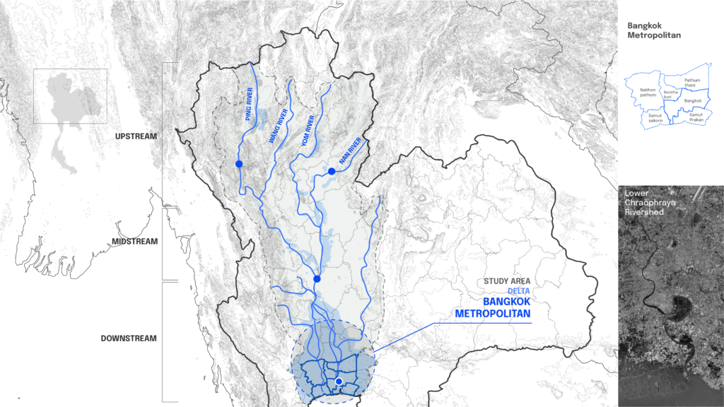
Bangkok: A City in Crisis
As the heart of Thailand’s largest watershed, Bangkok Metropolitan Region (BMR) is highly vulnerable to flooding. Situated at low elevation and experiencing prolonged rainy seasons, it faces multiple flood threats—from river overflow to urban runoff and coastal surges. The Bangkok Metropolitan Region (BMR), home to over 16 million people, is at the frontline of this crisis.
Historically, Bangkok was a city of canals and water-based transport, but rapid urbanization has replaced these natural flood buffers with impermeable surfaces. The consequences were starkly visible in 2011, when catastrophic floods submerged entire districts, displacing thousands. Traditional flood management strategies—such as dikes and drainage systems—are now proving inadequate against the increasing severity of extreme weather events.
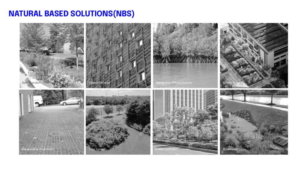
The Need for Nature-Based Solutions (NBS)
Around the world, major cities are incorporating NBS into flood resilience strategies. These solutions go beyond water management; they enhance biodiversity, improve air quality, and cool urban environments.
Examples include:
- Green roofs and facades – Absorbing rainfall and reducing urban heat.
- Retention ponds and bioswales – Managing stormwater while supporting ecosystems.
- Mangrove restoration and wetland conservation – Protecting coastal cities from storm surges.
“Despite their proven benefits, there is a lack of standardized tools to quantify the effectiveness of NBS in urban planning.”
This research aims to bridge this gap through the Flood Resilience Toolbox.
Introducing the Flood Resilience Toolbox
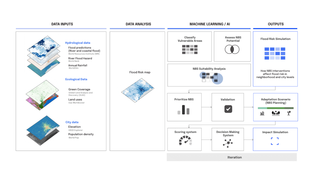
This AI-powered system enables urban designers, policymakers, and developers to simulate and assess the impact of different NBS strategies. By analyzing hydrological, ecological, and urban datasets, it helps cities identify optimal flood mitigation measures.
The research follows a data-driven methodology, integrating:
– Flood risk mapping – Identifying high-risk zones.
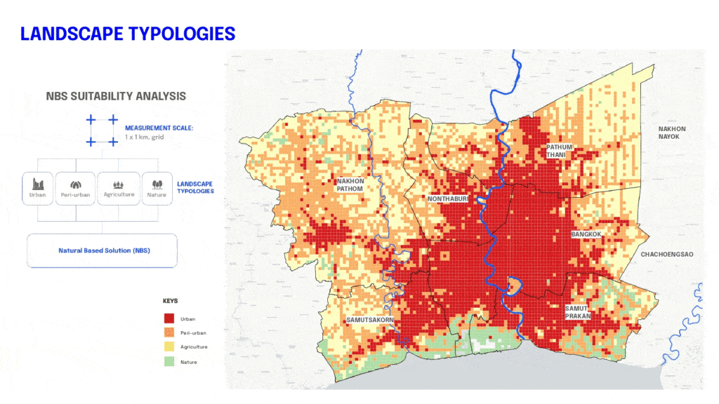
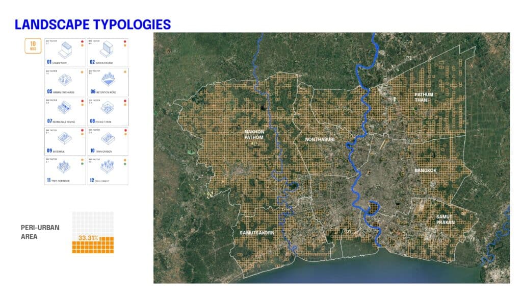
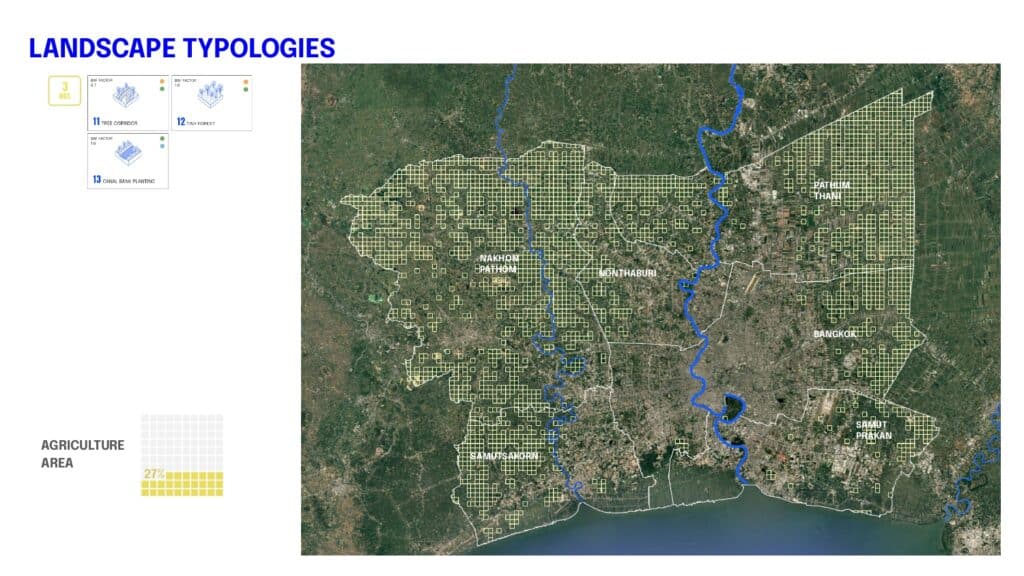
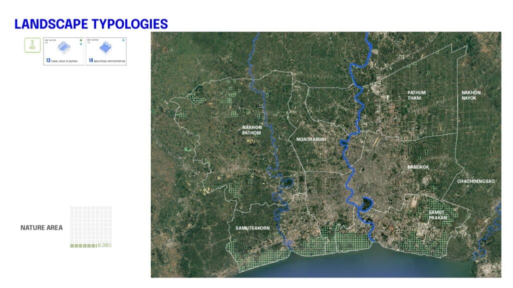
– Landscape typology classification – Determining urban, peri-urban, agricultural, and natural areas.
– NBS suitability selection – Mapping interventions based on environmental and urban factors.
– AI-powered impact assessment – Evaluating the effectiveness of NBS using machine learning.
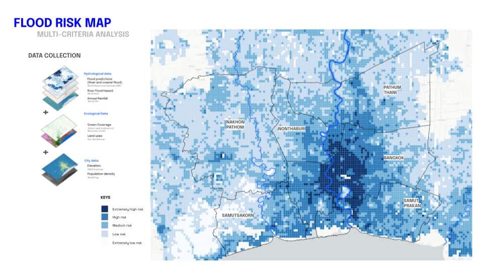
Here is the vectorized flood risk map from the previous term. The map highlights that areas of highest flood risk are concentrated in central Bangkok, gradually extending outward and northward.
Data, AI, NBS Suitability, & Mapping a Resilient Future
In order to select suitable NBS in parts of the city, I unify flood and urban data into 1×1 km grid and classified into landscape typologies which are urban, peri-urban, agricultural, natural) to determine suitable NBS solutions. This process ensures that NBS interventions are strategically placed for maximum impact.”
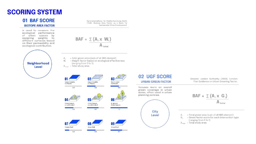
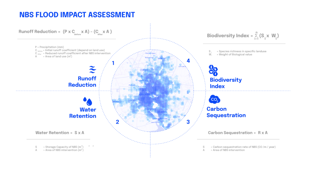
Scoring & Impact Assessment: Measuring NBS Effectiveness
To quantify NBS benefits, the toolbox employs two key scoring systems:
- BAF (Biotope Area Factor): Measures the proportion of permeable surfaces, assessing flood mitigation before and after intervention.
- UGF (Urban Green Factor): Evaluates green space quality, considering biodiversity, carbon sequestration, and flood resilience.
Introducing the Flood Resilience Toolbox
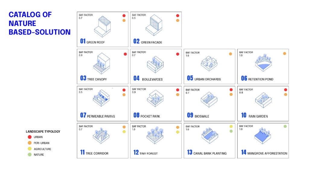
The toolbox includes a catalog of 14 Nature-Based Solutions, such as green roofs, rain gardens, and tree corridors. Each solution is evaluated based on its runoff reduction, water retention, and biodiversity benefits, ensuring that the most effective interventions are selected for each area.
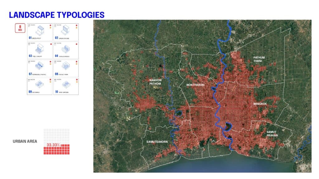
The toolbox has been applied to Bangkok Metropolitan Region, recommending targeted NBS for different landscapes:
- Urban areas: Green roofs, green facades, pocket parks, boulevards, permeable paving, pocket park, bioswales, rain garden.
- Peri-urban areas: Green roofs, green facades, urban orchards, retention ponds, permeable paving, pocket park, bioswales, rain garden, tree corridor, tiny forests.
- Agricultural areas: Tree corridors, tiny forest, canal-side planting.
- Natural areas: Wetland restoration, mangrove afforestation.
AI-Powered NBS Impact Simulation
Using machine learning models (such as Random Forest), the system optimizes NBS placement by:
- Selecting suitable interventions based on land use.
- Predicting BAF and UGF improvements post-implementation.
- Simulating flood mitigation impacts in different urban environments.
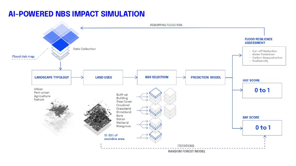
The toolbox assesses the impact of NBS using key metrics such as runoff reduction, water retention, carbon sequestration, and biodiversity enhancement. These metrics help urban planners understand the ecological and hydrological benefits of each intervention.
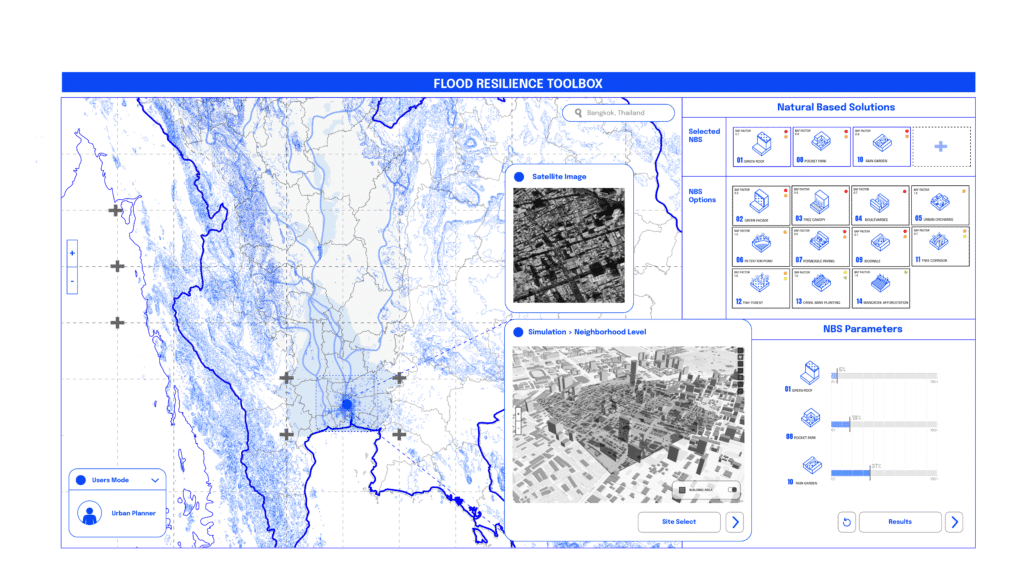
Here is a visual representation of the platform, which will be deployed as a web application in the next phase. The workflow begins with users selecting their area of interest. The portal then provides key site information, while AI-driven analysis recommends the optimal composition and proportion of Nature-Based Solutions (NBS). Users can either fine-tune the parameters to explore different scenarios or apply the suggested values to assess the projected impact effectively
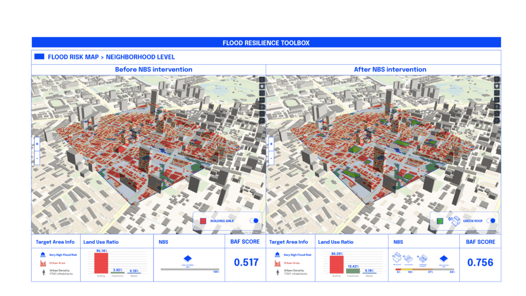
This picture below displays the results after users select NBS interventions at the neighborhood level. It presents land use proportions and a visualization of NBS implementation in the study area. At this scale, the toolbox demonstrates a significant reduction in flood risk. For example, in one area, the BAF score increased from 0.517 to 0.756, reflecting a substantial improvement in flood resilience.”
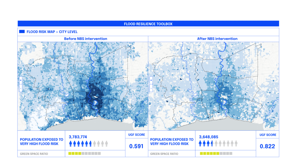
“When applied to Bangkok, the Flood Resilience Toolbox showed significant reductions in flood risk.“
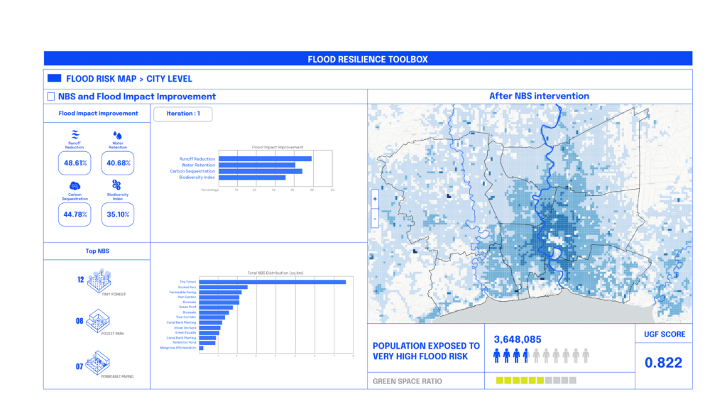
- UGF scores improved from 0.591 to 0.822 in pilot neighborhoods.
- The population exposed to extreme flood risk dropped from 3.78M to 3.65M.
- Runoff reduction and water retention metrics showed measurable improvement.
“These results demonstrate that NBS interventions are scalable, effective, and essential for future flood resilience strategie
Finally, users can assess the overall impact of the interventions, including NBS distribution, the most implemented NBS types, and their effects on flood mitigation and ecological enhancement.
From Research to Real-World Impact
The next phase involves deploying the Flood Resilience Toolbox as a web-based application, where users can:
🔹 Select an area of interest.
🔹 Receive AI-driven NBS recommendations.
🔹 Adjust parameters to explore different flood mitigation strategies.
🔹 Visualize projected impacts on flood risk, water retention, and ecosystem health.
Conclusion: Building a Flood-Resilient Future
The Flood Resilience Toolbox represents a data-driven shift in urban planning, offering a powerful tool to combat climate-driven flood risks. By integrating AI and NBS, cities like Bangkok—and beyond—can develop adaptive, sustainable strategies for long-term resilience.
With the right interventions, we can transform our urban environments into flood-resilient, livable cities.
