
Computational Tools for Thermally Comfortable Walks in Barcelona
On one of the sunniest days in the city of Barcelona, you want to go for a walk and get some fresh air but the heat from the sun makes you uncomfortable. Can you go for the walk without the sun making you completely sick?
The objective of this article is to study how computational tools can act as an aid to suggest shortest thermally comfortable routes to walk through at different hours of the day.
In the city of innovations, this study is to give a tool in the hands of citizens to help them make informed choices to plan the time and route of their walks. The tool gives the shortest thermally comfortable routes from the origin of the user to the intended destination, spread over different times in the day. It also gives the duration of the journey along with the distance that one has to cover.
This tool considers real-time climatic data from the open-source climate data and traverses it spatially with the shadows cast by the three-dimensional models of built fabric on the urban fabric. And thereby, generates a heat/shadow map over all the paths that lead to the destination. The tool thereafter selects the shortest walking distance from point to point that provides the maximum protection from the scorching sun. The routes generated by the tool often gives distances that could take longer to walk. Considering the thermal comfort of these distances the heat absorbed by the user along with the energy lost is less as compared to walking through routes that lack thermal comfort.
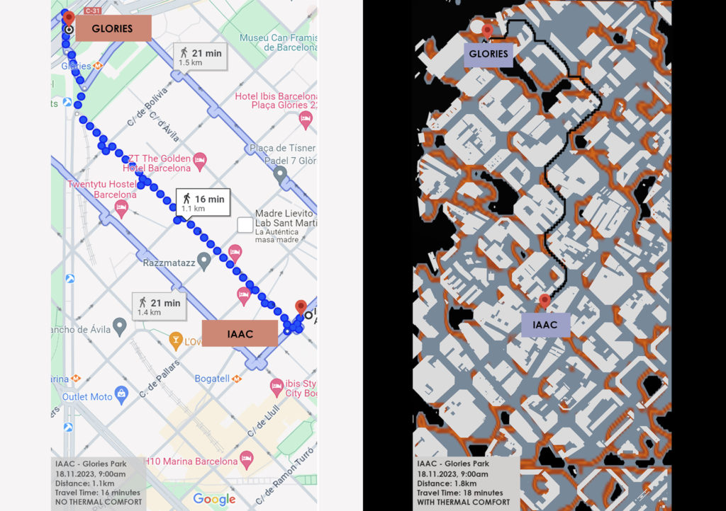
As an illustration, a user may wish to travel from the Institute for Advanced Architecture of Catalunya in the Poble Nou district to Glories Park. The walking distance as per Google Maps is 1.3km irrespective of the time of the day. The tool throws up different distances at different times of the day for the same journey. These distances are guided by the comfort and ease of walking through shaded routes and hence the distance travelled at 09:00am in the morning will differ from the distance travelled in the afternoon at 1:00pm.
Finally, to address the question that I raised in the header of this article, YES! This tool enables it’s users to make informed choices for their journeys on foot without making them feel sick! The tool could as well be tailored for bicycle routes across the city so that the users can make informed decisions for their cycling routes along distances with thermal comfort.
