
In the ever-evolving landscape of urban planning, the concept of “Biocities” has emerged as a beacon of hope for a sustainable future. As we delve into the intricacies of creating urban spaces that harmonize with nature, it becomes imperative to establish a shared language— a lexicon that defines the essence of Biocities. This blog post embarks on a journey of exploration and definition, delving into key terms that form the foundation of Biocity planning.
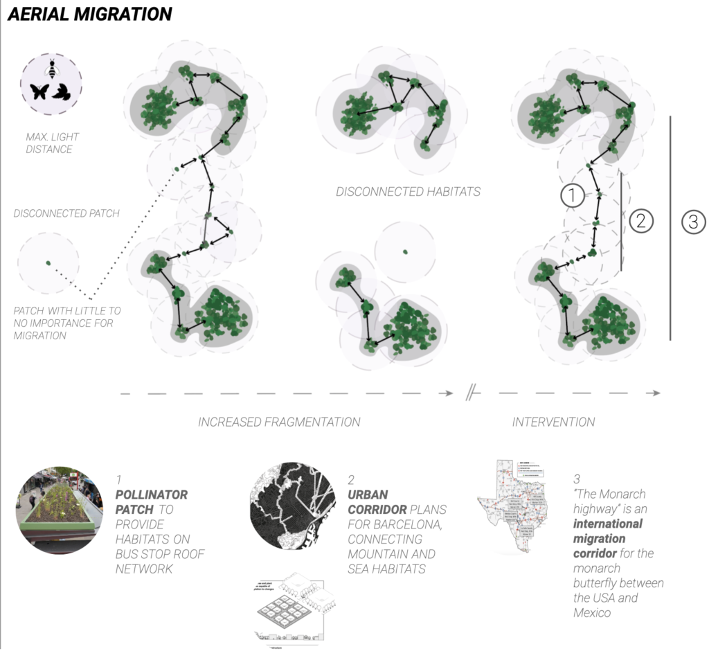
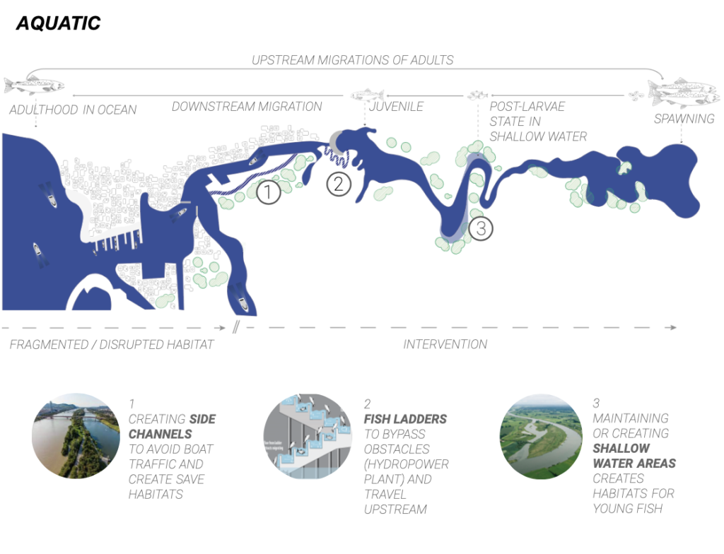
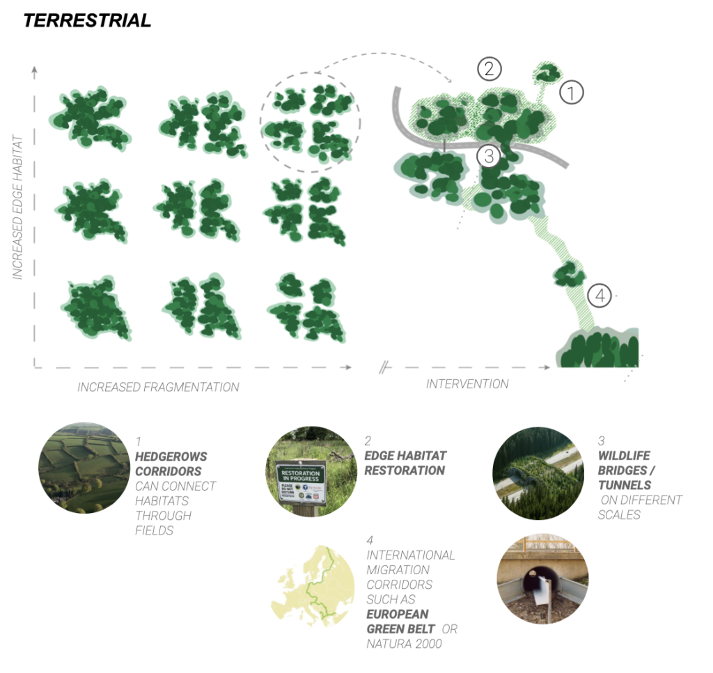
HABITAT FRAGMENTATION
Habitat restoration / Migration corridors
Habitat fragmentation occurs when continuous habitats break into smaller, isolated patches due to human activities or natural processes, restricting the movement of organisms. It can be caused by agricultural activity, infrastructure (streets, train tracks), the development of cities, or human disruption of population habitats using pollution (sounds/toxins/light). Also, climate change and natural disasters can contribute to habitat degradation.
Habitat fragmentation can disrupt migration paths and isolate populations, leading to a lack of genetic exchange, less genetic resilience, and possible extinction. It impacts the genetic exchange of plants as well., which depends on transport mechanisms such as birds (seeds) and pollinators (pollen) and wind .
Habitat fragmentation also disrupts food based migrations.
Reconnecting isolated patches and recovering fragmented habitats requires understanding plants, animal behavior, migration paths, and reproduction strategies.
Locating which natural patches are nonessential and which have immense ecological implementations is crucial for correctly planning a bio city.
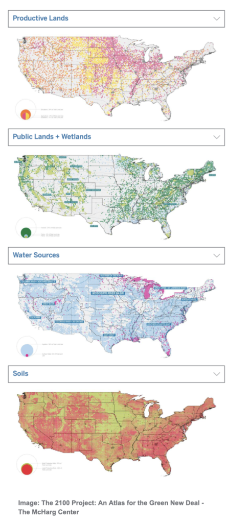
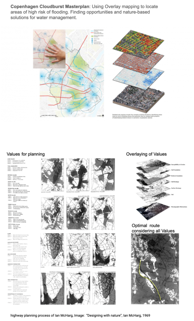
Overlay mapping
Overlay mapping involves superimposing various maps or layers of information onto a base map to analyze and plan for land use, environmental considerations, and other factors. McHarg emphasized the importance of using maps to understand the natural and cultural characteristics of a site and to guide decision-making in design and planning processes. This technique helped identify areas suitable for development and areas that should be preserved or protected based on ecological and social factors.
Through the overlay of maps that depict topography, soil quality, vegetation, and wildlife habitats alongside maps representing human aspects like transportation networks, residential areas, and industrial zones, planners gain a comprehensive understanding of the interplay between ecological considerations and human requirements.
Overlaying mapping aids biocity planning by integrating data layers (e.g., land use, ecology, climate) to identify green corridors, ecosystem services, and climate resilience. It informs community engagement and supports multi-criteria decision analysis. Additionally, it enables ongoing monitoring and adaptive management, promoting urban-nature harmony.
Land Ethics
a concept championed by philosophist Aldo Leopold, represents a profound moral framework deeply rooted in the belief that the natural world possesses intrinsic value. This perspective underscores the notion that our Earth and all its ecosystems are integral components of a broader moral community to which humans belong.
In essence, it accentuates the idea that our relationship with the environment transcends mere pragmatism, holding a profound ethical dimension that calls for the preservation, protection, and restoration of our planet for the well-being of both Earth itself and its diverse inhabitants.
At its core, this moral and philosophical framework seeks to instill responsible and ethical relationships between humans and the land. It urges a transformation in human values and attitudes towards the natural world, compelling individuals to acknowledge that the land possesses inherent worth and should not be viewed solely as a resource for exploitation. The land ethic advocates that humanity should prioritize the well-being of the entire ecological community and endeavor to coexist with the land harmoniously rather than exercising dominion over it.
Implications of a land ethic for human behavior include:
- A shift from anthropocentrism to biocentrism: Anthropocentrism is the belief that humans are the most important species on Earth. A land ethic challenges this view and emphasizes the importance of all living things.
- A rejection of the belief that humans have the right to dominate nature: A land ethic rejects the idea that humans can exploit and manipulate nature to our ends. We must instead live in harmony with nature.
- A commitment to conservation and restoration: A land ethic calls for us to conserve natural resources and restore damaged ecosystems. We must also be mindful of the cumulative impacts of our actions on the environment.
The land ethic is a complex and challenging concept, but it is essential for our time. As we face the growing challenges of climate change, pollution, and biodiversity loss, we must adopt a more ethical and sustainable relationship with the land. The land ethic provides a framework for doing so.
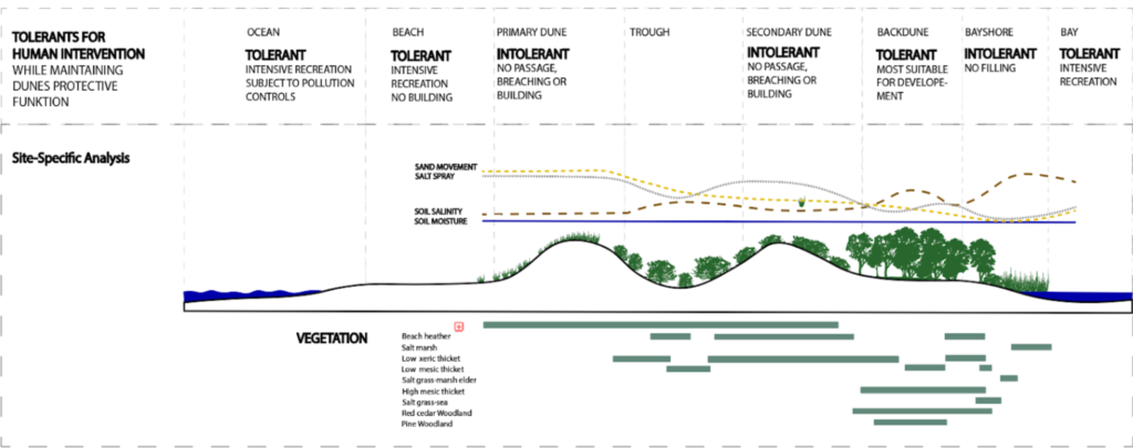
Site-Specific Analysis
Ian McHarg’s Site-Specific Analysis is a foundational concept in the field of environmental and ecological design. McHarg’s approach revolutionized how designers and planners consider the natural environment when shaping human landscapes. This method emphasizes a deep understanding of a site’s unique characteristics and the intricate interplay of natural systems. It involves an analysis of various factors to make informed and ecologically responsible design decisions.Key factors considered in McHarg’s site-specific analysis include:
Topography: The physical lay of the land, including elevation, slope, and drainage patterns, is a critical factor. Understanding topography helps in site grading, water management, and landscape integration.
Climate: Climate data, including temperature, precipitation, and seasonal variations, provides insights into design considerations such as energy efficiency, thermal comfort, and plant selection.
Soil: Soil analysis reveals soil types, compaction, and nutrient content. It is essential for understanding plant suitability, foundation design, and drainage solutions.
Vegetation: The existing vegetation, including native and non-native plant species, influences landscape aesthetics, ecological health, and habitat preservation.
Wildlife: Knowledge of local wildlife species, their habits, and habitats is essential for preserving biodiversity and minimizing ecological impact.
Water: Understanding the movement of water on and beneath the site helps in the design of stormwater management systems, wetland preservation, and water conservation.
Geology: Geological assessments provide insights into potential geological hazards, underground water sources, and the stability of the site.
Example:
Ian McHarg’s site-specific analysis identified zones within dunes suitable for human development while protecting their critical role in sea water, storm, and flood control. By analyzing topography, climate, soil, and vegetation, he delineated vulnerable areas for preservation. McHarg promoted site-adaptive design principles, elevating structures and integrating native vegetation, ensuring a balanced coexistence between human needs and the dunes’ ecological functions.
Reverencee::
Aerial Migration:
[1] Pollinator Gardens on Bus Stop Roofs Grow Across Europe
https://www.ecowatch.com/pollinator-gardens-bus-stop-roofs-europe.html
[2] Barcelona green infrastructure and biodiversity plan 2020. Summary
Illustrations: Nicolas Rotta
[3] Texas brakes for butterflies: “Monarch Highway” comes to IH35
Aquatic Migration:
[1] Tipp: Ausstellung „30 Jahre Donauinsel“ https://presse.wien.gv.at/2018/07/26/tipp-ausstellung-30-jahre-donauinsel-auf-der-inselinfo
[2] Adult Upstream Passage on the West Coast
[3] european center of river restoration
https://www.ecrr.org/River-Restoration/Habitats-and-biodiversity
Terrestrial Migration:
1] National geographics
“Hedges for Biodiversity”
https://education.nationalgeographic.org/resource/hedging-biodiversity/
[2]
Wetland restoration – conserve wildlife
http://www.conservewildlifenj.org/blog/tag/wetlands/
[3]
The Guardian
How creating wildlife crossings can help reindeer, bears – and even crabs
[4]
European Greenbelt
https://www.europeangreenbelt.org/
Overlay mapping
References:
“Designing with nature”,
Ian McHarg, 1969
The McHarg Center
https://unhabitat.org/sites/default/files/2022/12/white_paper_cities_and_nature_rev2.pdf
GIS for Urban Planning | Benefits,Applications
,&Tools,https://www.unearthlabs.com/blogs/gis-uses-urban-planning
Cloudburst Management Plan, Copenhagen, OPPLA Case Studies, https://oppla.eu/casestudy/18017
Land Ethics
References:
The Land Ethic, Aldo Leopold, https://www.aldoleopold.org/about/the-land-ethic
The Dialectical Links Between Environmental Ethics and Sciences,
Ricardo Rozzi,
University of Connecticut
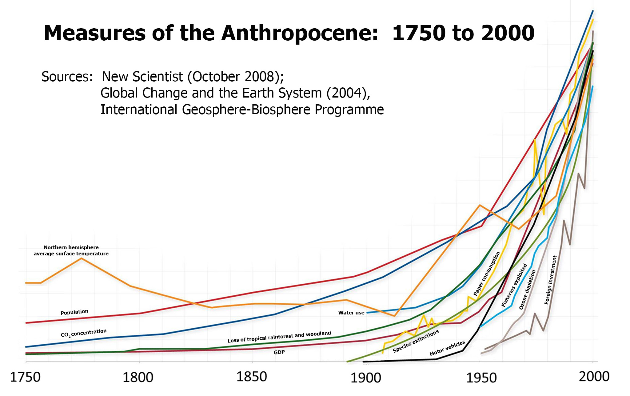
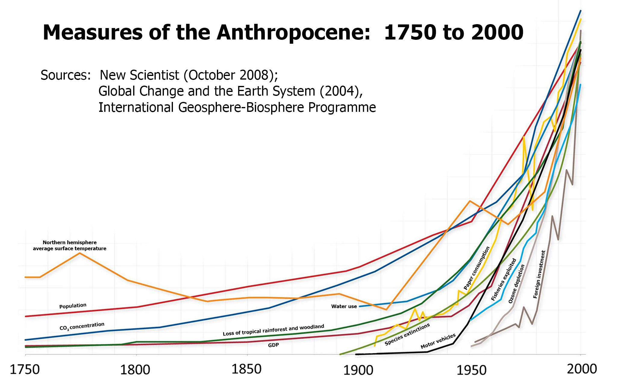
Img.:https://humanorigins.si.edu/sites/default/files/measures%20of%20the%20anthropocene.jpg
illustrations: Nicolas Rotta
