
Case Study of Ecological Restoration,
Human Presence and Design of Co-Existence
Introduction
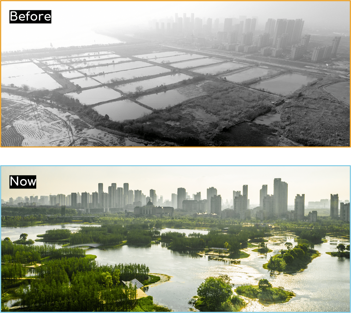
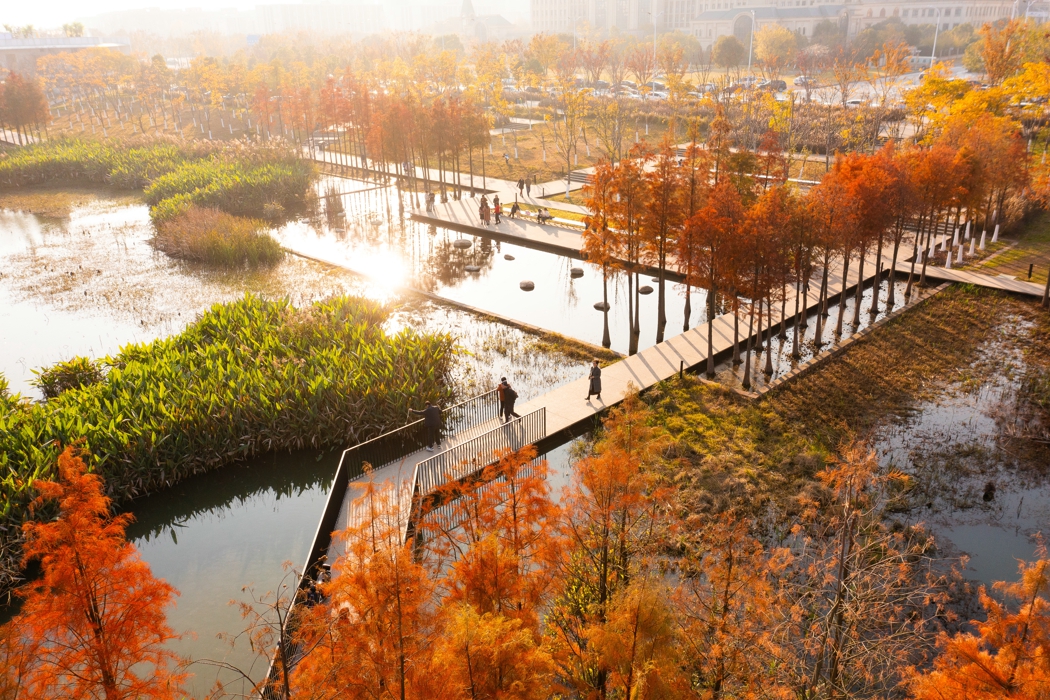
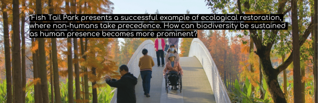
Fish Tail Park is located in the center of Nanchang City, a historic city in southeastern China with approximately 6.6 million residents, has experienced rapid urban growth and high-tech industrial expansion along the Gan River.
Is a large-scale ecological restoration project designed by Turenscape.
Within this context of accelerated urbanization, Fish Tail Park emerges as an experiment in ecological urbanism: a 137-acre intervention that increases flood storage capacity by the equivalent of approximately 284 Olympic-sized swimming pools, with measurable microclimatic benefits (4.6% cooler at the park’s periphery).
In our academic investigation, we analyzed the park as a living laboratory for understanding how ecological systems can be prioritized within dense urban environments and how increasing human presence may reshape that balance.

Methodology
Our study combined:
- Spatial analysis of the masterplan and ecological layers
- Mapping of vegetation distribution and seasonal dynamics
- Biodiversity analysis across trophic levels
- Mapping of human occupation intensity (flow, pause, rest, visual connection)
- Speculative spatial scenarios to test future human expansion
We worked directly from the project’s masterplan and ecological diagrams, reconstructing ecological and human occupation layers through diagrammatic overlays and pixel-based heatmap analysis.

Spatial analysis of the masterplan and ecological layers
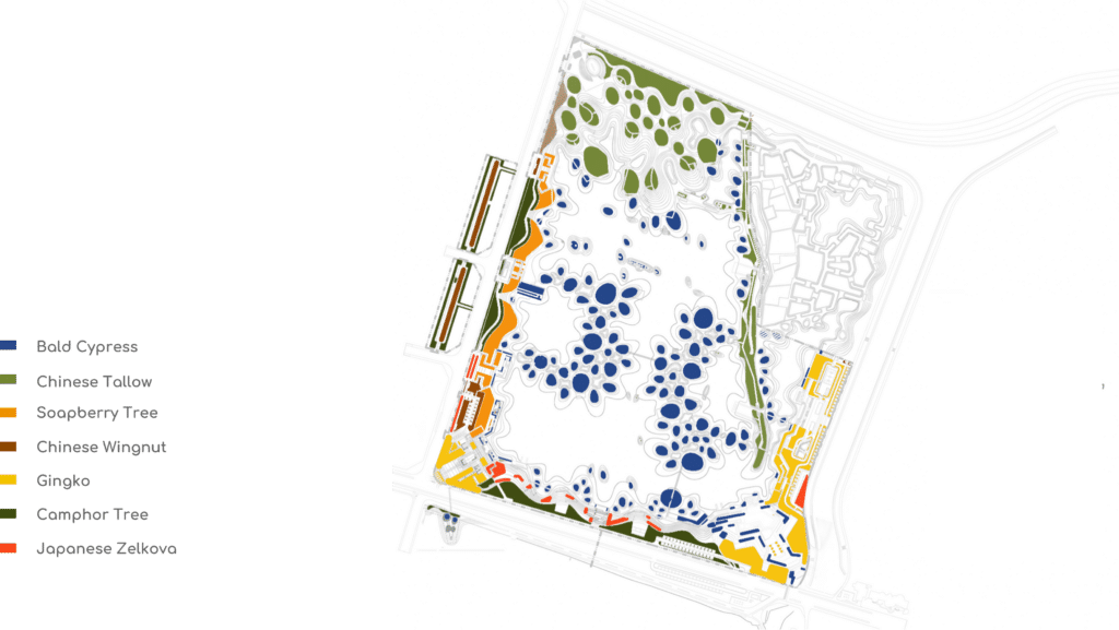
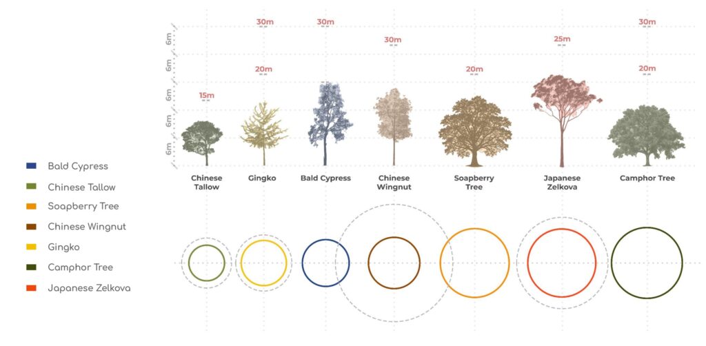
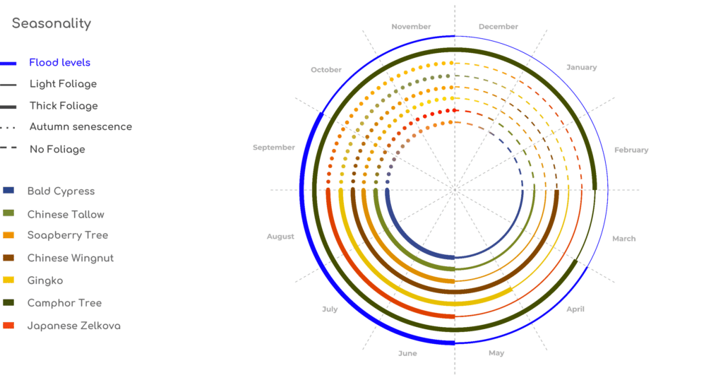

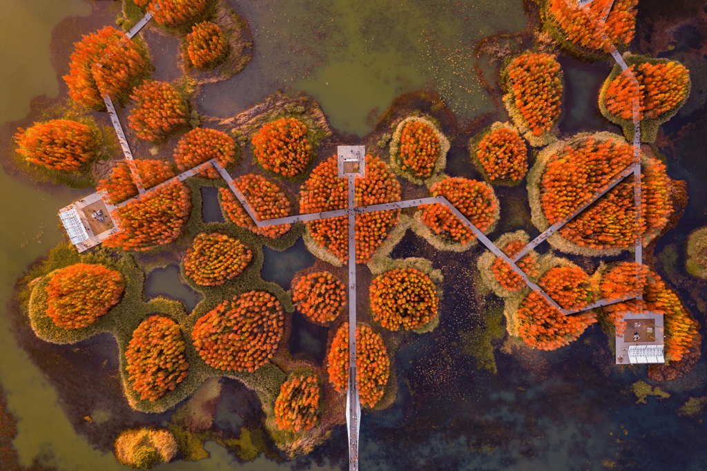
Ecological Stratification and Vegetation Logic
We did the stratification enables biodiversity across multiple ecological niches.

Fish Tail Park demonstrates a multi-species habitat network. Our ecological layer analysis documented
- Bird species such as Light-vented Bulbul, Oriental Magpie-Robin, Spotted Dove (p.16 FishTail Park)
- Pollinators including Asian honey bees and hoverflies
- Aquatic life such as carp fry, minnows, freshwater shrimp
- Amphibians and invertebrates across wetland zones
The structural diversity of vegetation supports nesting, shading, oxygenation, sediment trapping, and pollination processes

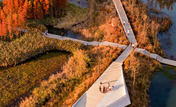
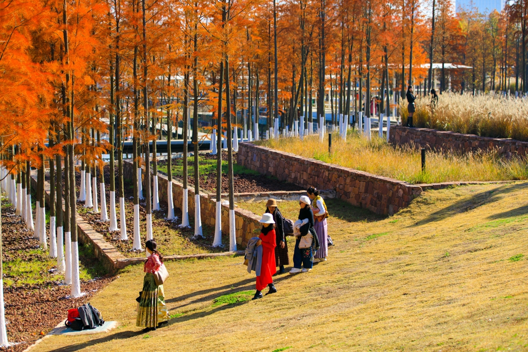
Mapping Human Presence
A key component of our research was mapping human spatial occupation through:

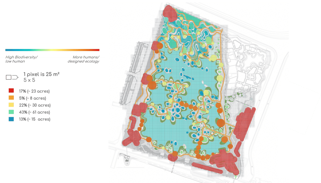
Using plan overlays we constructed a pixelated heatmap (1 pixel = 25m²) to measure spatial intensity of human activity
The analysis revealed:
- 17% High human-dominated zones
- 43% moderate ecological-human overlap
- 5%Medium human-dominated zones
- 13% No human activity
This mapping allowed us not only to visualize the ecological core versus human-concentrated areas, but also to clearly understand how coexistence is spatially negotiated within the park.
Nature is not relegated to residual or ornamental zones; rather, it occupies the structural core of the project. Human circulation, pause, and rest areas are strategically positioned around and carefully layered above – ecologically sensitive zones – reinforcing a hierarchy in which biodiversity and hydrological systems take precedence.

The Research Question
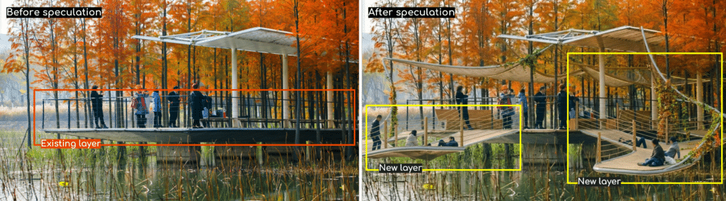
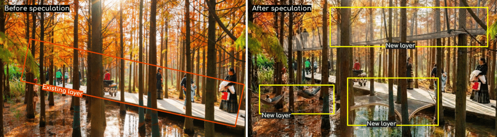
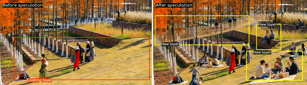
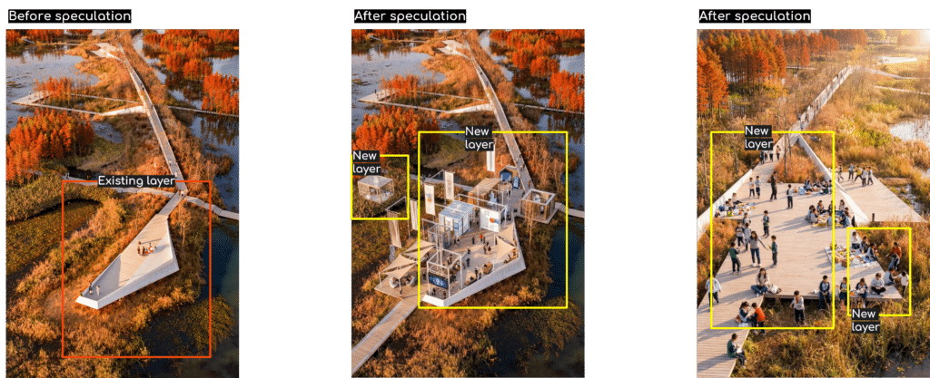
Speculative Layering: Testing Human Expansion
In order to test potential scenarios of increased human presence, we developed a speculative layering strategy, introducing hypothetical spatial additions above and below the existing elevated walkway These new layers were conceived as minimal, removable, and non-invasive structures that could expand opportunities for gathering, pause, and interaction without immediately replacing the existing ecological logic.
To support this speculative phase, we incorporated AI-assisted visual exploration (Formas AI) as a methodological tool. Through carefully structured prompts, we generated and tested spatial scenarios that explored realistic materiality, structural logic, scale, and ecological sensitivity. Rather than using AI as a form-generator detached from context, we employed it as a scenario-testing instrument — refining prompts iteratively to ensure that the outputs remained consistent with:
- Flood dynamics and seasonal variation
- Elevated walkway constraints
- Non-invasive construction principles
- Organic forms and natural textures
- Removability and minimal ecological disturbance
This process allowed us to visualize plausible future conditions while maintaining ecological realism. The AI-generated scenarios were not treated as final designs, but as speculative prototypes that helped us evaluate how small spatial modifications could influence patterns of occupation and ecological balance.
Subsequent pixel heatmap comparisons revealed that even modest spatial additions (1–3% increase in human occupation spatially) could compress ecological zones disproportionately, reinforcing the sensitivity of the existing equilibrium.
Although the spatial simulations indicated only a modest increase in human occupation, our analysis revealed that spatial impact alone is not an adequate measure of ecological pressure. Even limited physical expansion can generate disproportionate systemic effects.
We understood that intensifying human coexistence within the park may trigger secondary impacts across the ecosystem, including:
- Increased solid waste generation
- Greater maintenance demands and operational intervention
- Disturbance to nesting, feeding, and breeding patterns of some species
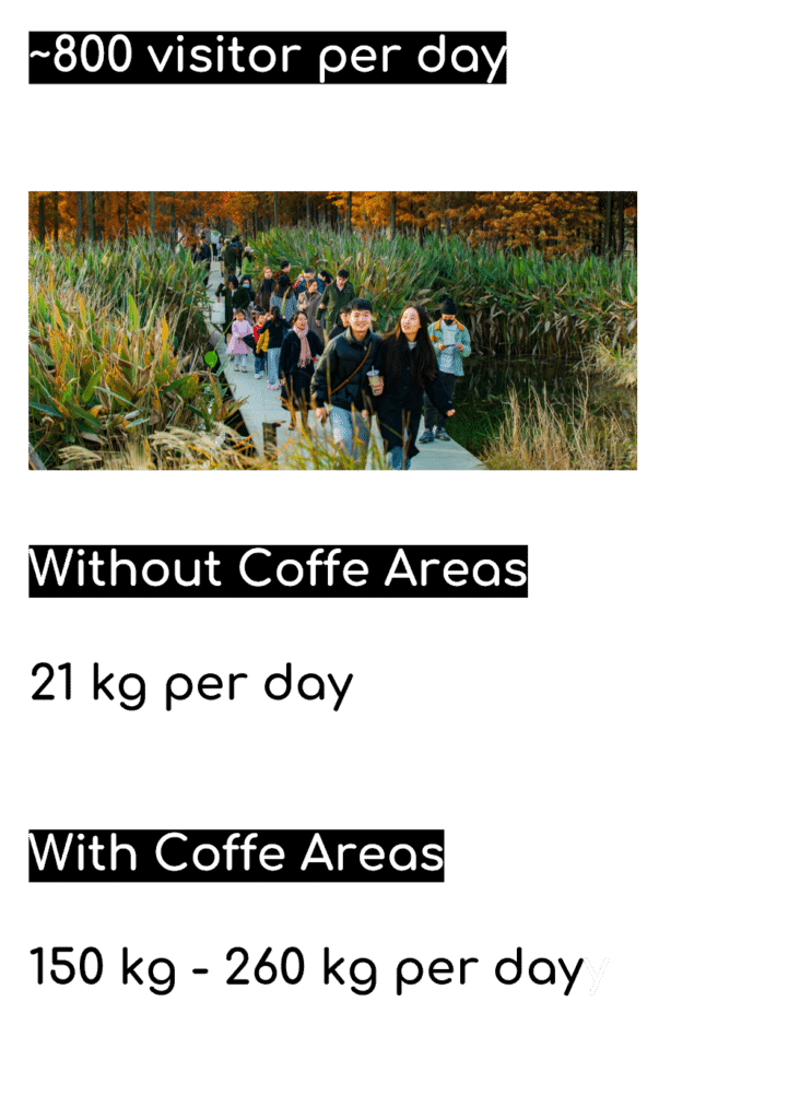
Our waste generation estimation demonstrates how the introduction of additional amenities – such as coffee areas – could significantly increase daily waste production. While the spatial footprint remains relatively stable, the metabolic footprint of the park expands considerably.
This finding shifts the discussion from purely spatial coexistence to ecological metabolism. Coexistence is not only about how much space humans occupy, but about how their presence transforms energy flows, material cycles, and maintenance regimes.
Through this combined approach , spatial mapping, ecological analysis, and AI-assisted speculation , we were able to test not only formal possibilities, but the ecological thresholds of coexistence itself.

Design Principles Derived from the Study
From our analysis, we propose three guiding frameworks:
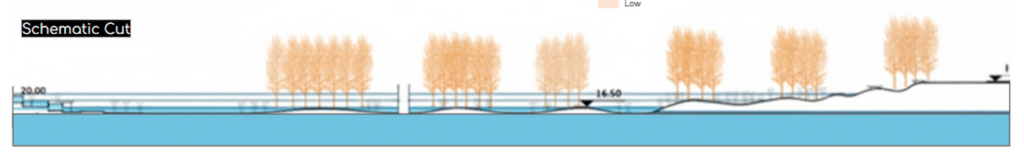
1. Rules for Water
- Design with flood cycles
- Avoid hard engineering where ecological storage is possible
- Treat water as system, not ornament
2. Rules for Trees
- Prioritize native and adaptive vegetation
- Enhance habitat quality
- Strengthen long-term resilience
3. Rules for Restoring Biodiversity
- Promote structural diversity
- Support multi-species interaction
- Build self-sustaining ecological networks

Conclusion
Fish Tail Park demonstrates that urban parks can operate as ecological infrastructures rather than aesthetic landscapes.
Our research highlights:
- The importance of hydrological logic
- The necessity of layered ecological design
- The fragility of biodiversity under incremental human intensification
The challenge for future urban ecological design is not how to add more human activity, but how to design interaction without ecological collapse.
