
Abstract
Dakar is Senegal’s capital city and rapidly urbanizing economic center. Today, Dakar’s urban area is home to 3.54M people, half of Senegal’s population, and generates 55% of the Country’s GDP. This growth is artificially constrained by an urban growth boundary, where new homes are informally built, and due to the city’s topography, a peninsula surrounded by the Atlantic Ocean.
Over the last 50 years, rapid densification without systems to meet new construction demand has contributed to Dakar’s 170,000-unit growing formal housing gap.
Understanding multiple levels of planning efforts and reports, this work aims to analyze determinants of housing quality that define SDG 11.1.1: “informal settlements”, “slums”, and “inadequate housing”. This approach enables Dakar and other cities to benchmark their progression towards adequacy.
Introduction
Since 2000, the city’s population has increased by 1.68 million people, with an annual growth rate of 3.21%. This growth has resulted land efficiency score of 0.7—less than 1 is considered dense. This densification has also led to housing availability challenges and affordability: Dakar’s current 170,000-unit housing gap will increase by 12,000 units annually, resulting in a projected 300,000-unit housing gap by 2035, the terminus of the region’s most rent master plan. Local support for construction industry growth, and specifically for the production of social housing, has been confirmed by a national home building program and programs to ascertain housing tenure and improve housing quality. That said, there is an urgent need for comprehensive urban planning strategies and investment in affordable housing initiatives to grow the housing stock with the city’s population.
Due to its cultural and economic importance for francophone Africa, recent discovery of oil reserves, sustained democracy through political turmoil, and demonstrated will to improve lives, Dakar can critically consider the indicators of Sustainable Development Goal (SDG) 11 and cross-cutting initiatives as mechanisms capable of attracting global public and private capital.
Past Planning Efforts
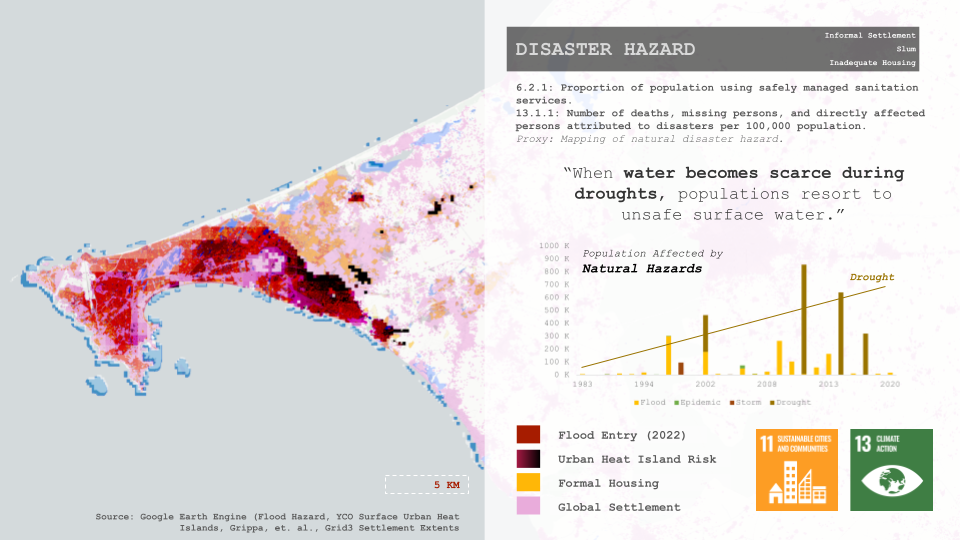
As Senegal’s primary port city, Dakar has consistently attracted migrants from other parts of the country over time. This influx of people notably intensified following Senegal’s attainment of independence in 1960. However, in 2009, a succession of droughts across the country fueled this migration further, making migrants settle in previously unoccupied lowland regions within the city.
Since 1948, the government has persistently attempted to manage this expansion through the design of master plans. However, these plans have largely failed, due to
- Disregard for the land-use regulations stipulated in the plans.
- Insufficient financial resources.
- Inability to adapt to the environmental conditions of the city.
The “Report for Project for Urban Master Plan of Dakar and Neighboring Area for 2035” highlights three significant master plans that shaped Dakar during French colonial rule before 1946. These plans, dating back to 1862, 1901, and 1915, established key areas like Medina City and Toundlands’ subdivision, focusing on the Plateau and new Medina City. The first plan by Émile Pinet Laparde in 1862 led to the construction of a deep seaport, while the 1901 plan aimed to expand the city due to population growth – creating Médina after a plague epidemic. The report also stated that the Plateau-Médina area served as a vital logistical hub, with the population reaching 92,600 by 1936, bolstering administrative, military, and commercial activities. These historic centers remain pivotal commercial hubs within the city, even today.
The report continues by detailing post-colonial urban planning efforts. In anticipation of Dakar’s growth, new master plans were created in 1946 and 1967. The 1946 plan, focusing on the Cap Vert region for the first time, prioritized social and institutional infrastructure development. This laid the foundation for future growth. In contrast, the 1967 plan served as a framework for more granular urban plans within specific districts. This period also saw a focus on social housing, leading to the establishment of SICAP (Société Immobilière du Cap Vert S.A.) in 1951 to address this need.(Africa Housing Finance Yearbook 2023)
However, in the 1990s, there was a shift in priorities away from social housing provision due to financial constraints. During this period, the Horizon 2025 Master Plan was developed with the aim of re-balancing the regional structure by creating new urban centers outside Dakar. Several projects based on this plan are currently being implemented, including the Blaise Diagne International Airport, extension of the Dakar-Diamniadio Highway, and the development of the Diamniadio urban center.
In response to the difficulties with adhering to past master plans, the government has undertaken Land Degradation Assessments alongside implementing the National Forestry Policy. A research paper by Dieng et al. (2023) highlights that although the policy’s focus is on sustainable forest management and biodiversity conservation, it also creates a foundation for broader environmental and social initiatives ,like the National Agency of Eco-villages (ANEV) – the first national program promoting ecologically, socially, and economically sustainable development across Senegal.Building on these efforts, the government introduced the Senegal Territorial Management Plan (PNAT) in 2021 (Project for Urban Master Plan of Dakar and Neighboring Area for 2035). This plan prioritizes improved land management, acknowledging past limitations in understanding local environmental conditions.
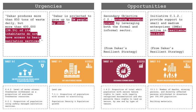
Furthermore, the government has moved beyond viewing housing solely as a spatial issue. It has implemented plans like the Dakar Resilience Strategy (2018) and the Plan Sénégal Emergent (2014 & 2018) to build economic and environmental resilience, crucial aspects of sustainable urban development (Plan Emergent Senegal PAP report, 2018 ). These efforts pave the way for the upcoming Urban Master Plan of Dakar for 2035.
Methodology
The methodology employed for this study involved a systematic approach to understanding the planning and resilience landscape of Dakar. It comprised the following steps:
- Document Review: The research team thoroughly examined all available documents related to planning and resilience initiatives in the city. These documents encompassed urban development plans, resilience strategies, and relevant policy documents.
- Challenges and Opportunities Identification: Through the document review process, the team identified key challenges and opportunities facing Dakar. These include issues such as housing shortages, infrastructure deficiencies, environmental vulnerabilities, and economic opportunities.
- Alignment with SDG Goals and Indicators: The identified challenges and opportunities were then correlated with the Sustainable Development Goals (SDGs) and their associated indicators. This step aimed to link the city’s specific circumstances to broader global sustainability objectives.
- Mapping of Indicators: The relevant SDG indicators or proxy measures were mapped to the specific context of Dakar. This involved contextualizing global indicators within the city’s unique socio-economic, environmental, and cultural context.
- Comparison with Planning Documents: The mapped indicators or proxy measures were then compared against existing planning documents for Dakar. This step sought to assess the extent to which the city’s planning efforts aligned with the identified indicators and addressed the associated challenges and opportunities.
- Analysis of Existing Projects: In addition to reviewing planning documents, the research team examined ongoing projects and initiatives in Dakar. This analysis aimed to gain insights into existing approaches and interventions aimed at addressing the identified challenges and opportunities.
By following this methodology, the study aimed to provide a comprehensive understanding of Dakar’s planning and resilience landscape, identify areas for improvement, and inform future policy and development efforts in the city.
Policy Goals
SDG 11, “make cities and human settlements inclusive, safe, resilient, and sustainable”.
In evaluating Dakar’s housing inadequacies and determining appropriate indicators for assessment, multiple factors come into play:
Dakar currently faces a formal housing gap of 170,000 units, projected to increase by 12,000 units annually, culminating in a staggering 300,000-unit deficit by 2035. This substantial gap underscores the pressing need for effective evaluation and intervention.
Defining housing quality in Dakar, Senegal, involves assessing various factors related to the Sustainable Development Goals (SDGs), particularly Goal 11, which focuses on sustainable cities and communities. This goal includes indicators for adequate, safe, and affordable housing, with a specific emphasis on slums, informal settlements, and inadequate housing.
In alignment with Sustainable Development Goals (SDGs), indicators were prioritized based on pressing needs. Desktop research confirmed severe deficits in water, waste, and shelter infrastructure. The risk of insufficient infrastructure to human and environmental health is exacerbated by habitual plastic pollution, rising droughts, and urban heat, which pose risks to both human and environmental health.
(Harmonized metadata template – format version 1.1).
A pivotal goal emerges: to address the housing deficit while simultaneously achieving economic and environmental sustainability. Circular economic housing, which entails systemic plastic conversion, presents a promising opportunity for integrating health and housing needs with broader socio-economic and environmental objectives.
Assessing capacity involves evaluating existing housing stock and ongoing public efforts to address the housing deficit. Initiatives such as JIRA’s 2035 master planning documents and SENHABITAT’s 100,000 homes program indicate a concerted public endeavor to mitigate Dakar’s housing challenges.
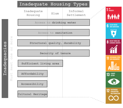
Lastly, defining inadequacies in housing involves considering various dimensions beyond mere physical structures. Per Habitat III Issue Paper #22, housing must provide essential services such as access to clean water, sanitation, structural durability, and security of tenure to be deemed formal. Additionally, indicators of slum conditions, such as overcrowding and insufficient living space, further underscore housing inadequacies:
The following is a condensed summary that outlines key points to consider when evaluating housing quality in Dakar using SDG indicators:
- SDG Goal and Target: Goal 11 aims to make cities inclusive, safe, resilient, and sustainable. Target 11.1 focuses on ensuring access to adequate, safe, and affordable housing while upgrading slums by 2030.
- Indicator Information: Indicator 11.1.1 measures the proportion of urban population living in slums, informal settlements, or inadequate housing. This indicator helps assess housing quality and identify areas requiring improvement.
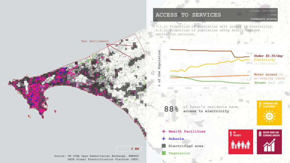
- Related SDG Indicators: The quality of housing is interconnected with other SDG indicators, such as access to improved water (6.1.1), sanitation (6.2.1), electricity (7.1.1), and public transit (11.2.1), as well as broader indicators like poverty rate (1.1.1), informal employment (8.3.1), and public space safety (11.7.2).
- Measurement and Data Collection: Data for evaluating housing quality in Dakar can be collected through national censuses and household surveys like Demographic Health Surveys (DHS) and Multiple Indicator Cluster Surveys (MICS). Data collection methods must ensure the reliability and accuracy of information related to housing conditions.
Considering these factors and using the SDG framework, policymakers and urban planners in Dakar can develop targeted strategies to improve housing quality, addressing challenges such as informal settlements, slums, and inadequate housing. The ultimate goal is to create a more sustainable and inclusive urban environment.
Defining Inadequacies
- To be considered informal, housing must not provide any of the following services (Habitat III Issue Paper #22):
- Access to water, drinking water protected from outside contamination,
- Access to sanitation, a facility with a waste disposal system that does not necessitate human contact,
- Structural quality and durability, not built in a hazardous location and able to protect occupants from extreme climate conditions,
- Security of tenure, effective protection of peace and dignity through guardrails against forced eviction by law or arrangement.
- To be considered a slum, housing may also be overcrowded, not provide sufficient living area, or not provide one of the above requirements. For a living area to be sufficient no more than three people may share the same habitable room (UN MDG 7 Target 7.D).
- To be inadequate, housing may also not bear one of the following provisions (Article 25 of the Universal Declaration of Human Rights):
- Affordability, or bearing a cost of 30% of the household’s income
- Accessibility, by means of services for vulnerable populations or proximity to job opportunities via public transit,
- Cultural adequacy, in its “respect and accountability for expression of cultural identity and ways of life.”
Analysis
Inadequacies were correlated with relevant open source spatial data to scope and identify regions of concern. Analysis of inadequacies related indicators may support stakeholders intending to address Dakar’s housing challenges effectively.
Land Use
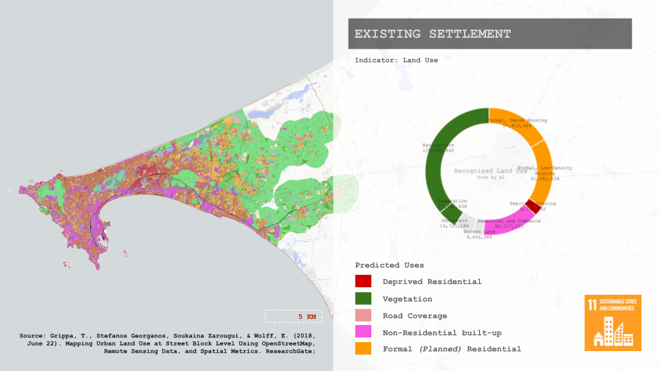
Dakar’s land use is a critical aspect of its urban and environmental dynamics. Through comprehensive mapping, it has been observed that a significant portion of the city’s land is dedicated to agriculture, alongside extensive built-up areas. This combination underscores the city’s dual identity as both an urban center and an area with agricultural significance. Built-up areas signify urban development and infrastructure expansion within Dakar. These areas include residential, commercial, industrial, and institutional zones, reflecting the city’s rapid urbanization and economic growth.
Dakar’s land use was understood through the existing land use map and 2019 machine-learning analysis of land uses. The urban growth boundary instituted by the land use plan effectively limits city expansion but accommodates the influx of new slum dwellers, highlighting a critical inadequacy in housing provision.
One crucial aspect of Dakar’s land use strategy is the protection of fertile soil. Given the significance of agriculture to the local economy and food security, preserving fertile soil is essential for sustaining agricultural productivity and mitigating the risks of soil degradation and urban expansion.
Access to Water
Indicator 6.4.2: Level of Water Stress
Assessing the level of water stress is crucial for understanding Dakar’s water resource management and sustainability efforts. This indicator, defined as freshwater withdrawal as a proportion of available freshwater resources, provides insights into the city’s water usage relative to its freshwater availability.
Mapping Dakar’s water resources involves identifying and the distribution and availability of freshwater sources within the city and its surrounding areas. This includes surface water bodies such as rivers, lakes, and reservoirs, as well as groundwater aquifers. Additionally, gathering statistics on freshwater availability per capita allows for an assessment of the amount of freshwater resources available to each individual within Dakar’s population. This data is essential for understanding the adequacy of water supply and identifying areas of water scarcity or stress.
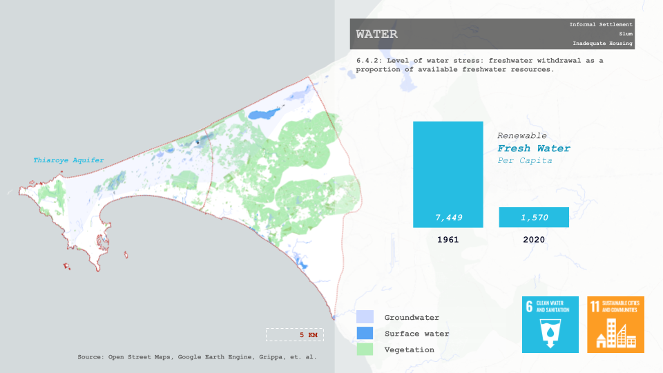
Water stress is directly related to Dakar’s broader challenges and opportunities, particularly in the context of urbanization, population growth, and sustainable development. As the city continues to expand, the demand for water resources increases, placing pressure on existing water infrastructure and ecosystems.
Access to Sanitation
Proxy Indicator: Mapping of Natural Disaster Hazard
Sanitation is understood through the risk of natural disasters and environmental hazards, focused on indicators related to disaster risk reduction, including access to safely managed sanitation services and the impact of disasters on the population. Dakar’s resilience and emergency preparedness is crucial to maintaining sanitary waste disposal practices.
Indicator 13.1.1: Number of Deaths, Missing Persons, and Directly Affected Persons Attributed to Disasters per 100,000 Population
Indicator 6.2.1: Proportion of Population Using Safely Managed Sanitation Services.
Mapping natural disaster hazards involves identifying and visualizing potential hazards such as floods and UHI within Dakar and its surrounding areas. This mapping allows for the assessment of areas prone to different types of disasters and facilitates targeted mitigation and adaptation strategies. Understanding the distribution of natural hazards helps prioritize infrastructure investments and emergency response planning to mitigate risks and protect vulnerable communities.
Security of tenure
Securing land tenure rights is essential for promoting stability, livelihoods, and socio-economic development in Dakar. This section focuses on indicators related to land tenure security, including legal recognition and perceived security of land rights among the adult population.
Indicator 1.4.2: Proportion of Total Adult Population with Secure Tenure Rights to Land
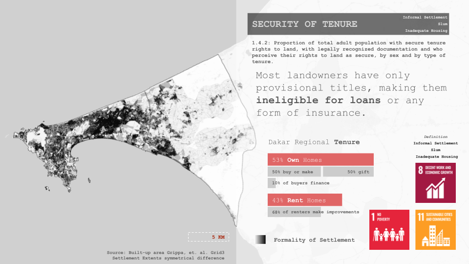
Land tenure security is fundamental for ensuring equitable access to land resources, promoting investment, and reducing conflicts over land ownership. Understanding the proportions of secure land tenure rights helps inform policies and programs aimed at enhancing tenure security and fostering sustainable land management practices.
Overcrowding
Overcrowding is a critical urban issue that affects living conditions, infrastructure strain, and overall quality of life. This section delves into indicators related to population density and land consumption rate, shedding light on urban densification trends and their implications for Dakar’s residents.
Indicator 11.3.1: Ratio of Land Consumption Rate to Population Growth Rate
Proxy indicator: Population Density
Overcrowding and urban densification are pressing concerns in Dakar, particularly in neighborhoods experiencing rapid population growth. Since 2000, Dakar’s growth has primarily concentrated in the Pikine neighborhood, which has witnessed significant expansion in both size and floor area. Over this period, Pikine has sustained a fourfold increase in population, making it a notable case study for urban densification.
Housing Quality
Housing quality is essential for ensuring the well-being and safety of Dakar’s residents. This section examines indicators related to building materials and sanitation services, providing insights into the adequacy of housing conditions and infrastructure provision.
Indicator 6.2.1: Proportion of Population Using Safely Managed Sanitation Services
Building Materials and Sanitation Services Proxy
The quality of housing in Dakar is influenced by factors such as building materials, construction practices, and access to basic services like sanitation. Understanding the relationship between housing quality and sanitation services helps identify areas of improvement and prioritize interventions to enhance living conditions.
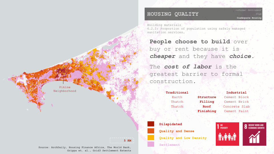
People often choose to build their homes rather than buy or rent due to cost considerations and the desire for autonomy. However, formal construction faces barriers, particularly the high cost of labor, which can deter individuals from investing in formal housing options.
Location | Access to Services
Access to essential services is fundamental for ensuring a high quality of life and promoting sustainable development. This section examines indicators related to access to electricity and safely managed sanitation services, providing insights into the availability and adequacy of basic amenities for Dakar’s residents.
Indicator 7.1.1: Proportion of Population with Access to Electricity
Current Efforts
Dakar’s current planning efforts were analyzed for their contribution to housing adequacy.
Recommendations
- Pikine-Guediawaye Plastic Conversion Program: The Senegalese government’s new Urban Master Plan for Dakar and Neighboring Areas for 2035 prioritizes environmental improvement and stakeholder participation. This plan includes specific actions for the Pikine-Guediawaye axis, such as: Relocating the Pompier intercity bus station to the new Beaux Maraichers bus terminal, and a land restructuring and regularization program in the Pikine Department. A complementary proposal can include the following:
- A Plastics Conversion Program for Bioclimatic Housing To further enhance the plan, a plastics conversion program can be implemented in Pikine and Guediawaye. This program would:
- Address plastic waste problem: Convert excess plastic into construction materials, tackling the plastic pollution issue seen on the Senegalese coastline.
- Promote sustainable housing and services: Use recycled plastic for construction materials, providing alternative to traditional concrete structures. Additionally,The government’s proposed “waste-to-energy” study could explore the feasibility of integrating plastic waste conversion into the energy solution.
- Partnership with the Housing and Living Environment Improvement Programme (UrbaSEN):This program ensures that women can receive ‘revolving funds’- a microloans initiative that funds their home improvements (World habitat, 2017). This approach can be adapted to support the plastics conversion program. This would:
- Encourage community participation: Residents could participate in collecting plastic waste and potentially even learn basic construction skills using recycled materials.
- Align with the Master Plan’s goal of community engagement: Involving residents fosters ownership and builds a platform for sharing and disseminating information about the 2035 Master Plan.
- A Plastics Conversion Program for Bioclimatic Housing To further enhance the plan, a plastics conversion program can be implemented in Pikine and Guediawaye. This program would:
- Secure Land Tenure for Sustainable Development: Ensuring secure land tenure in informal settlements is critical for long-term investments in housing and agricultural development. This stability reduces forced migrations due to land degradation and fosters a foundation for growth (Dieng et al., 2023). To achieve this, national and regional plans in Senegal need to be harmonized. This includes aligning the National Territorial Management Plan (PNAT), the Project for Urban Master Plan of Dakar and Neighboring Area for 2035, and the Regional Territorial Management Scheme (SRAT) with key policies.
- Agro-lifestyle Settlement Plans for New and Existing Cores: The proposed Land Use Plan for Daga Kholpa and Diamniadio aims to achieve equitable development across the Dakar region and counterbalance existing urban centers (Project for Urban Master Plan of Dakar and Neighboring Area for 2035). To achieve this, the plan should incorporate sustainable practices like community gardens and agroforestry into the settlements. This promotes food security, enhances environmental quality, and aligns with the Master Plan’s goal of preserving the urban environment with stakeholder participation. Integrating national programs like the National Agency for the Great Green Wall (ANGMV) and the National Agency of Eco-villages (ANEV) is crucial. The ANGMV links national goals to regional efforts for environmental restoration. The ANEV, focused on transitioning villages towards sustainable living, aligns perfectly with the overall objective.
Conclusion
- Land Use Dynamics: The predominance of built-up areas and agriculture covering over 70% of Dakar’s total area underscores the city’s rapid urbanization and agricultural significance. Efforts to preserve fertile land and limit urban expansion are good, but further integration of environmental protection measures is necessary to ensure sustainable land management practices.
- Environmental Considerations: While the current urban development plan includes provisions for recreational and green spaces surrounding water bodies, there’s a notable absence of strategies addressing environmental protection and utilization. Incorporating measures to mitigate the urban heat island (UHI) effect and enhance ecosystem services can bolster the resilience and sustainability of Dakar’s urban landscape.
- Alignment with Population Density: The proposed restructuring areas in the current plan do not seem adequately aligned with population density patterns. Prioritizing areas for development and infrastructure investment based on population density can optimize resource allocation and promote equitable access to services and amenities across the city.
- Differential Treatment of Areas: An important aspect overlooked in the current plan is the lack of differentiation in addressing areas based on their existing conditions. Prioritizing interventions and tailor-made strategies for areas with distinct socio-economic, environmental, and infrastructural challenges can enhance the plan’s effectiveness and inclusivity.
In summary, while Dakar’s current urban development plan shows efforts towards preserving land and integrating green spaces, there are notable shortcomings regarding environmental protection, alignment with population density, and differential treatment of areas. Addressing these gaps through comprehensive planning strategies that prioritize sustainability, resilience, and inclusivity is essential for fostering balanced and equitable urban development in Dakar.
Sources
- Grippa, T., Stefanos Georganos, Soukaina Zarougui, & Wolff, E. (2018, June 22). Mapping Urban Land Use at Street Block Level Using OpenStreetMap, Remote Sensing Data, and Spatial Metrics. ResearchGate.
- Population Density; Population Grid; Built-Up Area; Surface Water; Flood Hazard; and YCO Surface Urban Heat data from Google Earth Engine Data Catalog (GEE) Website[https://developers.google.com/earth-engine/datasets]. Retrieved April, 2024
- Dakar’s Resilience Strategy Report (2016). Resilient Cities network Website [ https://resilientcitiesnetwork.org/dakar/ ] Retrieved April 2024.
- Hana Abdel (2021). Living in Dakar, A Study of Senegalese Housing & Future Development. ArchDaily website [https://www.archdaily.com/955865/living-in-dakar-a-study-of-senegalese-housing-and-future-development] Retrieved April, 2024.
- Housing Depravity data from Grippa et al. (2018), “Mapping Urban Land Use at Street Block Level Using OpenStreetMap, Remote Sensing Data, and Spatial Metrics.” Retrieved from https://github.com/ANAGEO/R_stuff/tree/master/VSURF_FeatureSelection_RF_Optimization/Data_Dakar.
- Globally Recognized Land Use data from OpenStreetMap Contributors. (2024). Dakar administrative level 2 map. Retrieved April 22, 2024, from https://www.openstreetmap.org.
- Groundwater data from Roger, J., Duvail, C., Barusseau, J. P., Noël, B. J., Nehlig, P., & Serrano, O. (2009). Geological map of Senegal at 1/500,000, northwest, northeast, and southwest sheets. Ministry of Mines, Industry and SMEs, Directorate of Mines and Geology, Dakar, 3 sections ;
- Surface Water data from European Commission Joint Research Centre (EC JRC), & Google. (n.d.). Global Surface Water. Available from 1984-03-16 to 2022-01-01. Retrieved April 22, 2024, from ee.Image(“JRC/GSW1_4/GlobalSurfaceWater”), accessed from Pekel, J.-F., Cottam, A., Gorelick, N., & Belward, A. S. (2016). High-resolution mapping of global surface water and its long-term changes. Nature, 540, 418-422. https://doi.org/10.1038/nature20584 ; and
- Housing Depravity data showing Vegetation from Grippa, T., Georganos, S., Zarougui, S., Bognounou, P., Diboulo, E., Forget, Y., Lennert, M., Vanhuysse, S., Mboga, N., & Wolff, E. (2018). Data for: Mapping Urban Land Use at Street Block Level Using OpenStreetMap, Remote Sensing Data, and Spatial Metrics. Retrieved from https://github.com/ANAGEO/R_stuff/tree/master/VSURF_FeatureSelection_RF_Optimization/Data_Dakar.
- Flood Event Extent data showing the flood entry in 2022 from O’Regan, K. (2023). Open CEMS-Flood Data. Retrieved April 23, 2024, using Python scripts for analyzing the flood in Senegal on August 30, 2022. Available at https://confluence.ecmwf.int/display/CEMS/Open+CEMS-Flood+Data
- Flood Risk data from the European Space Agency EO4SD-Urban. (2020). Flood Hazard Map for Dakar. Retrieved April 22, 2024, from https://datacatalog.worldbank.org/dataset/dakar-senegal-flood-hazard-map-esa-eo4sd-urban/resource/5e45b862-ddac-4ed8-81b9-0f552544726b ;
- Urban Heat Island Effect data from Yale Center for Earth Observation (YCEO). (n.d.). YCEO Surface Urban Heat Islands: Pixel-Level Annual Daytime and Nighttime Intensity [Data set]. Available from 2003-01-01 to 2018-12-31. Retrieved April 22, 2024, from ee.ImageCollection(“YALE/YCEO/UHI/UHI_yearly_pixel/v4”). Accessed from Chakraborty, T., & Lee, X. (2019). A simplified urban-extent algorithm to characterize surface urban heat islands on a global scale and examine vegetation control on their spatiotemporal variability. International Journal of Applied Earth Observation and Geoinformation, 74, 269-280. https://doi.org/10.1016/j.jag.2018.09.015 ;
- Housing Depravity data showing Formal Housing from Grippa, T., Georganos, S., Zarougui, S., Bognounou, P., Diboulo, E., Forget, Y., Lennert, M., Vanhuysse, S., Mboga, N., & Wolff, E. (2018). Data for: Mapping Urban Land Use at Street Block Level Using OpenStreetMap, Remote Sensing Data, and Spatial Metrics. Retrieved from https://github.com/ANAGEO/R_stuff/tree/master/VSURF_FeatureSelection_RF_Optimization/Data_Dakar
- Human Settlement data showing Global Human Settlement Layer (GHSL) from European Commission & Statistical Office of the European Union. (2021). Global Human Settlement Layer: Dakar, Senegal. Publications Office of the European Union. ISBN 978-92-76-20306-3. https://doi.org/10.2785/706535.
- Quality of Built Surfaces data showing Grippa gradient by depravity of housing from Grippa, T., Georganos, S., Zarougui, S., Bognounou, P., Diboulo, E., Forget, Y., Lennert, M., Vanhuysse, S., Mboga, N., & Wolff, E. (2018). Data for: Mapping Urban Land Use at Street Block Level Using OpenStreetMap, Remote Sensing Data, and Spatial Metrics. Retrieved from https://github.com/ANAGEO/R_stuff/tree/master/VSURF_FeatureSelection_RF_Optimization/Data_Dakar ;
- Built Surfaces data from European Commission, Joint Research Centre (EC JRC). (n.d.). GHSL: Global built-up surface 1975-2030 (P2023A) [Data set]. Retrieved April 22, 2024, from ee.ImageCollection(“JRC/GHSL/P2023A/GHS_BUILT_S”). Available at https://ghsl.jrc.ec.europa.eu/documents/GHSL_Data_Package_2023.pdf ; and
- Buildings data from OpenStreetMap Contributors. (2024). Senegal Buildings (OpenStreetMap Export). Retrieved April 22, 2024, from https://data.humdata.org/dataset/hotosm_sen_buildings.
- Population Grid from European Commission, Joint Research Centre (JRC). (2023). GHS-POP R2023A – GHS population grid multitemporal (1975-2030) [Data set]. European Commission. Retrieved from ee.ImageCollection(“JRC/GHSL/P2023A/GHS_POP”).
- Housing Depravity data from Grippa et al. (2018). Data for: Mapping Urban Land Use at Street Block Level Using OpenStreetMap, Remote Sensing Data, and Spatial Metrics. Retrieved from https://github.com/ANAGEO/R_stuff/tree/master/VSURF_FeatureSelection_RF_Optimization/Data_Dakar.
- Access to Health Facilities data showing Health Facilities (UN OCHA Open Humanitarian Exchange) from Humanitarian OpenStreetMap Team (HOT). (2024). Senegal Health Facilities (OpenStreetMap Export). Retrieved April 22, 2024, from https://data.humdata.org/dataset/hotosm_sen_health_facilities
- Access to Education data showing Schools (UN OCHA) from Humanitarian OpenStreetMap Team (HOT). (2024). Senegal Education Facilities (OpenStreetMap Export). Retrieved April 23, 2024, from https://data.humdata.org/dataset/hotosm_sen_education_facilities
- Electrified Areas data showing Electrified Areas (ENERGY DATA Electrification Platform (GEP) from World Bank. (2024). Senegal Electrification Scenarios for 2030. Retrieved April 23, 2024, from https://electrifynow.energydata.info/explore/sn-2?year=2030&scenario=0_0_1_0_1_0&filters=r5_846011%7Cr0.009_81.702%7C1_2_5_6_7_3%7Cr0_285.722%7Cr0_60.648%7Cr10.475153_55593.977%7CDakar_Diourbel_Fatick_Kaffrine_Kaolack_Kedougou_Kolda_Louga_Matam_Saint%20louis_Sedhiou_Tambacounda_Thies_Ziguinchor.
- Global Night Light data from NASA’s Black Marble (n.d.). Retrieved April 22, 2024, from [https://blackmarble.gsfc.nasa.gov/Tools.html]
- Net migration and Senegal Urban Population data from Macrotends.net [https://www.macrotrends.net/global-metrics/countries/SEN/senegal/net-migration] open database
- UN Habitat report on the 2030 agenda and the sustainable development goals, from [https://sdgs.un.org/un-system-sdg-implementation/united-nations-human-settlements-programme-un-habitat-34617]. Retrieved April 2024.
- UN SDG indicator metadata (Harmonized metadata template – format version 1.1)
- National Action Plan within the Framework of the Open Government Partnership (NAP-OGP) 2021-2023. Retrieved from the Senegal Operational and Monitoring Office website (https://www.senegal-emergent.com/en/composante/sicap/)
- “The ‘Development Syndrome’: Building and Contesting the SICAP Housing Schemes in French Dakar (1951–1960)” (January 2018), Canadian Journal of African Studies / Revue canadienne des études africaines, 51(2), 1-30, DOI: 10.1080/00083968.2017.1411820.
- African Development Bank website (https://www.afdb.org/en/projects-and-operations/p-sn-ea0-001),
- Ministry of Urban Renewal Housing and Living Environment Republic of Senegal (MULHP) & Japan International Cooperation Agency (JICA).(2016). Report for Project for Urban Master Plan of Dakar and Neighboring Area for 2035. (2016). Final Report Volume 2.
- Dieng, M., Mbow, C., Skole, D. L., & Ba, B. (2023), “Sustainable Land Management Policy to Address Land Degradation: Linking Old Forest Management Practices in Senegal with New REDD+ Requirements,” Front. Environ. Sci. 11:1088726, doi: 10.3389/fenvs.2023.1088726. Retrieved from the International Forum of Sovereign Wealth Funds website (https://www.ifswf.org/members/fonds-souverain-dinvestissements-strat%C3%A9giques-sa),
- Dakar Resilience Strategy official document, MobiliseYourCity Global Monitor 2024 (https://www.mobiliseyourcity.net/sites/default/files/2024-04/07_Dakar%2C%20Senegal.pdf).
- Administrative Levels data showing Communes and Municipalities from the Office for the Coordination of Humanitarian Affairs West and Central Africa (ROWCA). (2018). Senegal – Subnational Administrative Boundaries. Retrieved April 24, 2024, from [https://data.humdata.org/dataset/cod-ab-sen]. Updated by OCHA/ROWCA, August 4, 2018.
- Settlement Extents Data. Grid3 website[https://data.grid3.org/datasets/0ff6ed6a125249c9ac1ad022e391e749/about]. Retrieved April, 2024.
- The spatial Distribution of Population in Senegal, 2020. WorldPop Hub Website [https://hub.worldpop.org/geodata/summary?id=6426]. Retrieved April, 2024.
- Department of Urbanization and Architecture (DUA) (2016).
- Senegal data. UN OCHA Open Humanitarian Exchange website [https://data.humdata.org/group/sen?]. Retrieved April, 2024.
- Senegal – Global Electrification Platform (GEP). Energy Data Infor Website [https://energydata.info/dataset/senegal-global-electrification-platform-gep]. Retrieved April, 2024.
- Chiavina, Marcello; Freire, Sergio; Alessandra Carioli; MacManus, Kytt (2023).
- Migration Profile Senegal. Joint Research Centre Repository (JRC). European Commissions Website [https://publications.jrc.ec.europa.eu/repository/handle/JRC117945] Retrieved April, 2024.
- Housing Finance in Senegal Overview. Centre for Affordable Housing Finance in Africa Website [https://housingfinanceafrica.org/countries/senegal/]. Retrieved April, 2024.
- Senegal Data. The World Bank Group website [ https://data.worldbank.org/country/SN ]. Retrieved April, 2024.
