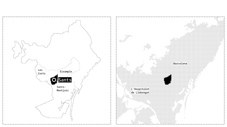
When we locate Sants within Barcelona, it appears to be on the city’s edge. However, when considering the metropolitan area as a whole, Sants is actually closer to the center. Historically, Sants was one of the towns surrounding Barcelona until its annexation in 1897. Its agricultural and industrial roots contribute to a unique neighborhood identity—one that fosters a sense of community and belonging among its residents.
This project is structured into three chapters: firstly, we outline our project’s objectives and methodology; secondly, we document our analytical processes; thirdly, we describe how we translated our analysis into specific design interventions.
00_POTENTIAL-ISSUE(S)-OBJECTIVES
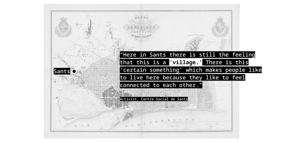
potential – Sants has a unique identity shaped by its long-standing tradition of neighborhood cooperation, solidarity, and pride in its working-class roots.
issue(s) – weakened civic engagement in Sants and city-wide identity loss.
objective(s) – “learning from Sants”: leverage public spacesand local identity to invite residents into networks of cooperation to promote replicable strategies for the metropolitan region.
00_METHODOLOGY
We started with an approach rooted in the public spaces to understand how these can reflect local identity and be sites to engage residents into networks of cooperation. We studied historical representation and pride and the local networks of cooperation to get a sense of the neighborhood identity, and looked into the demographic composition of the neighborhood and sentiments of the public to better understand the perspectives of neighbors. To understand the urban identity, we looked at visual data in the form of Festa Major de Sants posters from the Barcelona Municipal archive and conducted three in-depth interviews with Sants residents who are very involved in local networks. All three had lived in Sants for a majority or all of their lives.
We investigated networks of cooperation by looking at descriptive, textual data from the websites of associations in Sants, sourced from Municipality data collection. For demographic information, we pulled from census data and then to understand neighbor perspectives, we pulled textual anecdotal data from google places and oral data from interviews in public spaces.
So, to summarize, we explore historical representation and local pride by analyzing posters and mapping themes from Sants celebrations. We map the associative fabric of Sants by analyzing local organizations. We explore the resident perspective through the demographic composition of the neighborhood and understanding how public spaces are perceived google places reviews and interviews.
01_ HISTORICAL REPRESENTATION AND PRIDE
To better understand Sants identity and what makes the neighbors proud of their district we started with this question: How do symbols of the Festa Major de Sants posters show up in the urban fabric?
We visualized our data analysis process in the following cube, starting from the posters, analyzing them and ending in what these say of the heritage landscape.
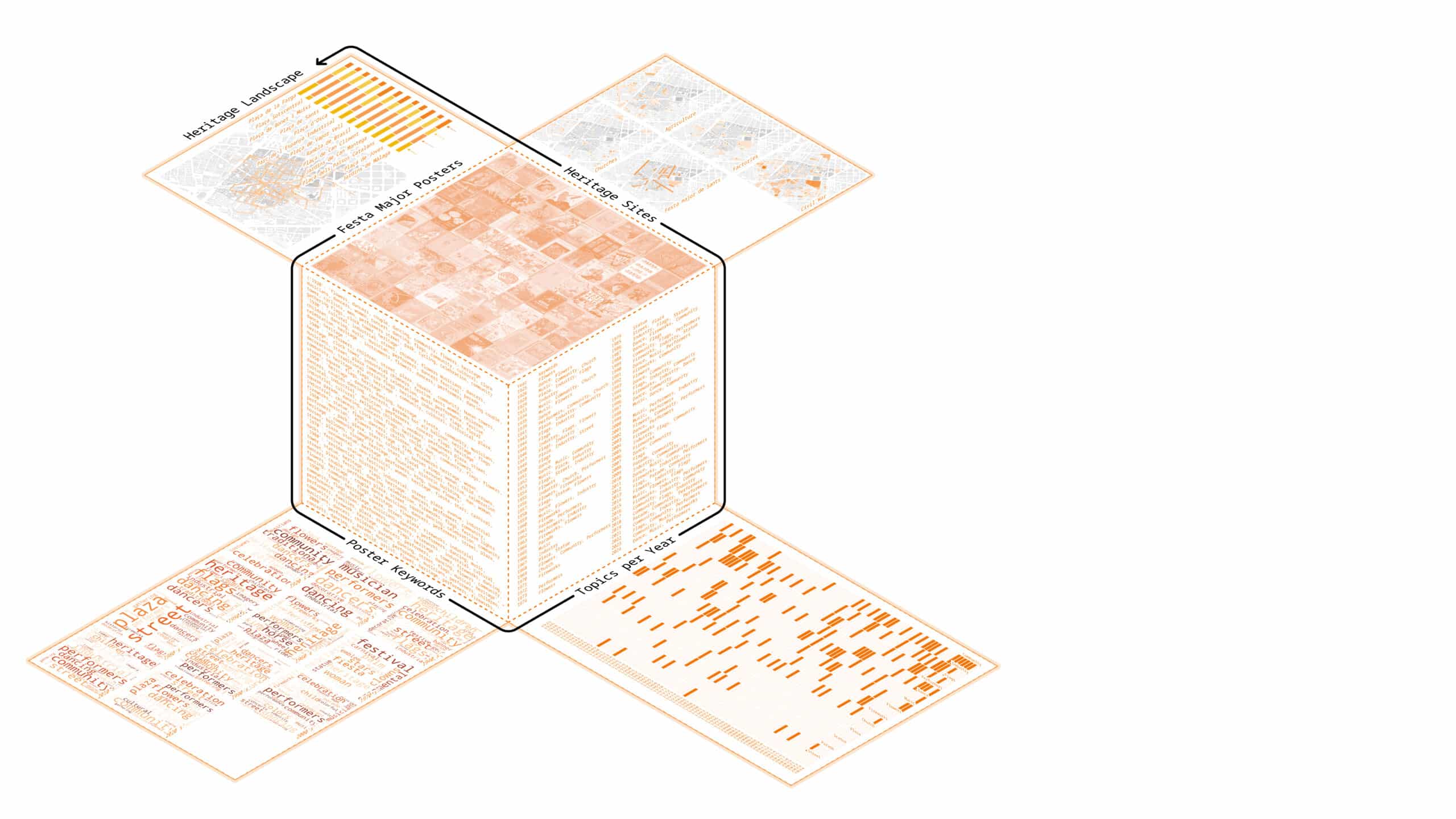
We started by collecting all the posters and were able to gather 81, ranging from 1925 to the most recent Festa in 2024.
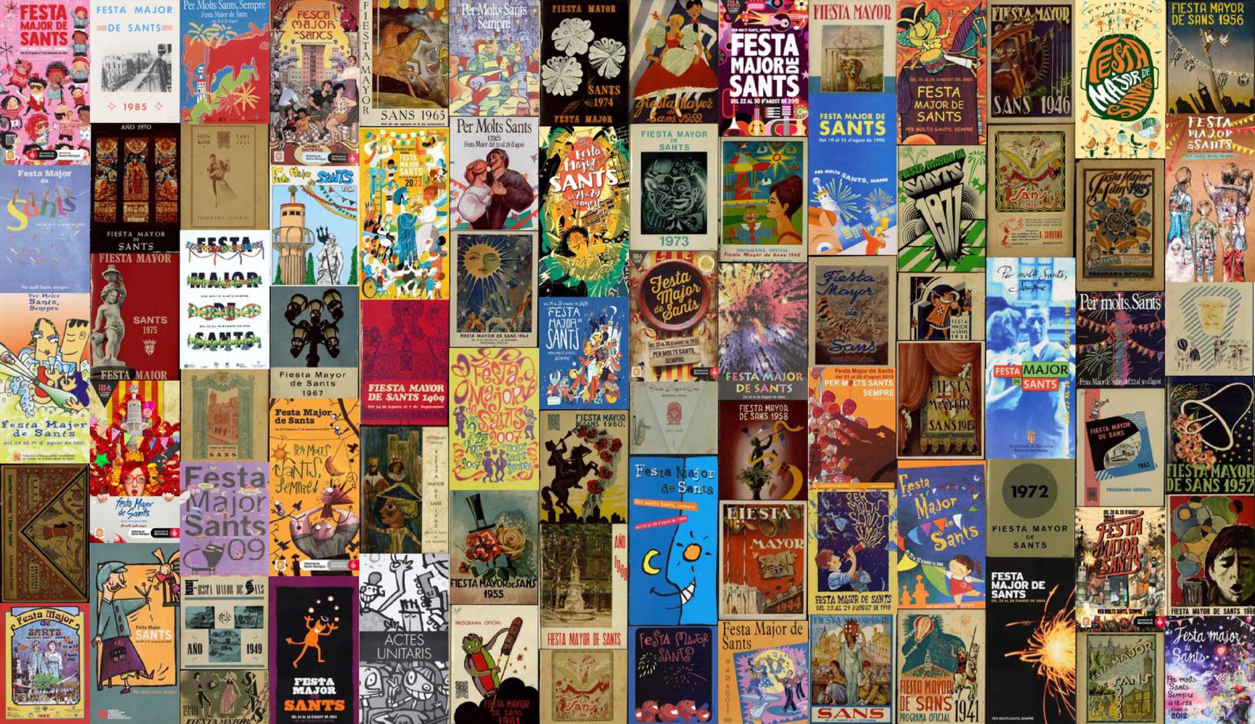
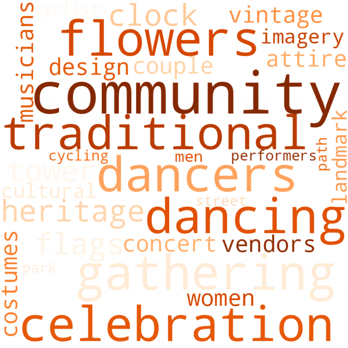
To analyze these posters, which we gathered from the Arxiu Municipal and Ajuntament, we followed two steps. The first step involved analyzing each poster individually, extracting keywords with Natural Language Processing, related to categories such as architecture, public spaces, activities, symbols, and people.
From this process, we identified the main keywords that appeared over the years and listed the most common ones. This allowed, in a second step, to reanalyse them and understand which concepts persisted throughout the decades.

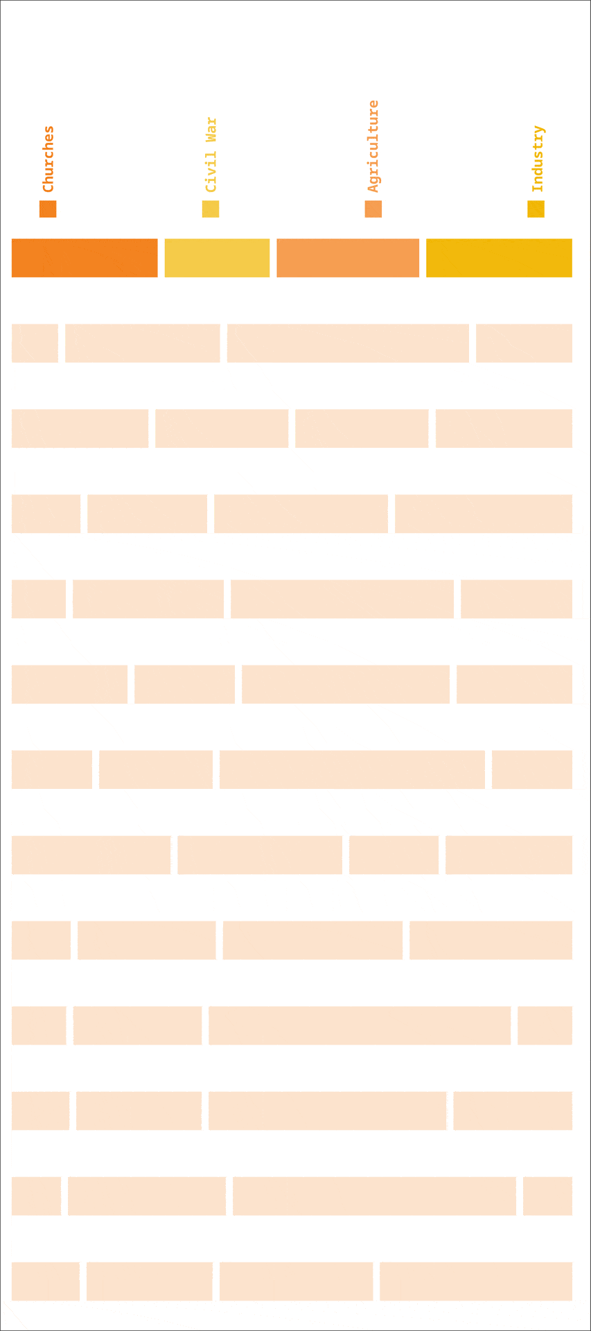
By doing this we could understand that the posters reflect the historical and social transformations of the neighborhood, identifying its key elements. From its agricultural roots, relating for example to the symbol of the flower, to its industrial roots and labor movements in the early 20th century, through the dictatorship, and the urban renewal of the 80s. Later, the neighborhood shifted to symbols of community celebration, and the posters began to emphasize festive elements like music, dance, and fireworks.
As a next step, we gathered datasets related to this heritage, from the webpage Memoria de Sants, and mapped them within the neighborhood. The agricultural and industrial sites, the shelters from the civil war and churches related to them.
The first map illustrates Sants’ agricultural past, highlighting the masias, sequias and agricultural areas, reflecting its rural character prior to its urbanization.
In relation to its industrial past, the factories remain as a legacy of the industrial operations, where workers organized themselves creating spaces for leisure. Some of these factories are still there today and have been repurposed as public spaces, such as libraries and cultural centers.
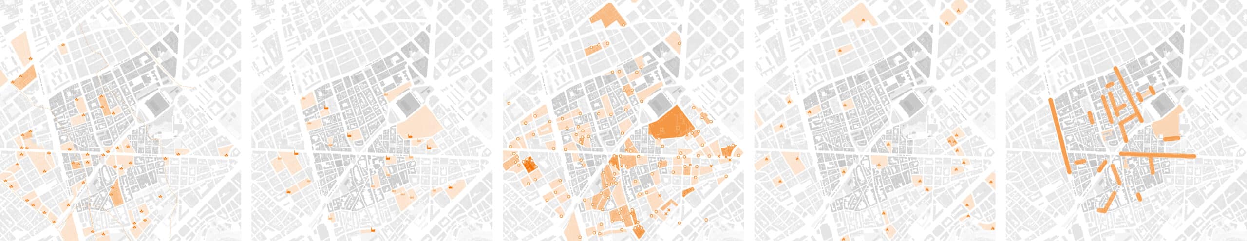
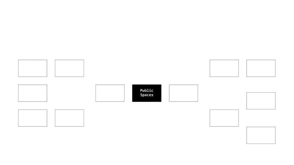
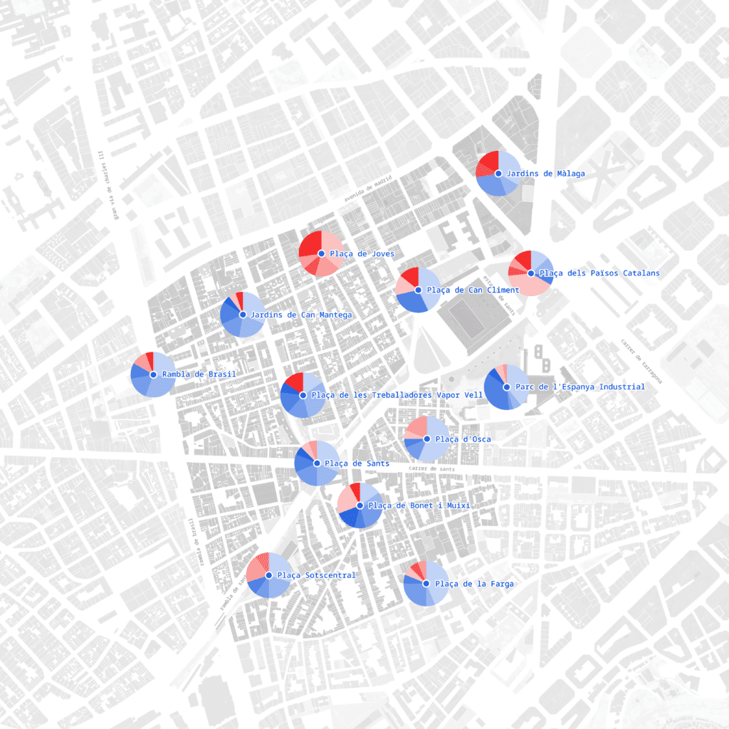
As a summary of this chapter, we mapped the proximity of these heritage sites to the main plazas of the neighborhood in order to see its coverage.
02_NETWORKS OF COOPERATION
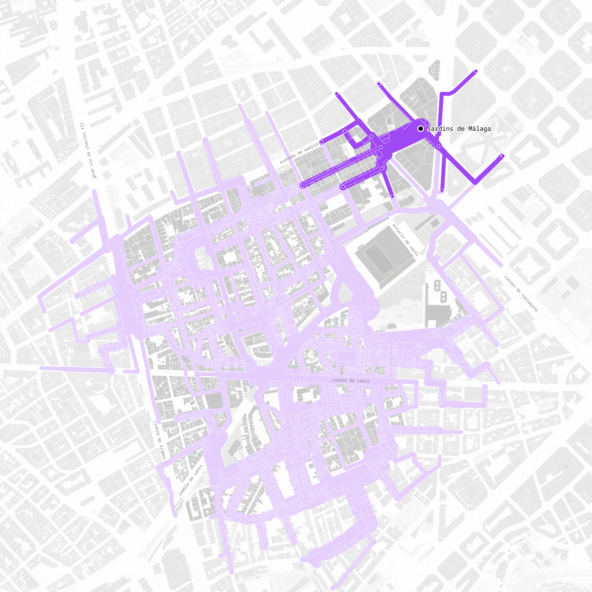
We followed the thematic path of working class organization into the present and asked where and how to situtate the current state of neighborhood association in the urban fabric.


The input of this workflows is municipal dataset of point locations of associations and ends with profiling public spaces based on the association activities. We used to map out the density, of associations – which translates into a first into a first image telling us about hotspots the actual concentration. The dataset also provided us with website links of these associations that we webscraped, to pursue at a more nuanced image.
The websites contained information on the associations and their activity, however we had to manually enrich this scraping. We used a natural language processing workflow to extract thematic focal points structured along six categories.


We then remapped into urban space to see the thematic landscapes and their density in the barrio. Similiar to the poster analytic we could then use this self created dataset to create profiles of squares and parks in the neighborhood.
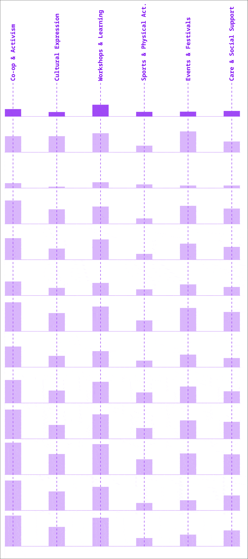
Further this investigation lead us to the insight that this unique form of neighborhood organization is currently on decline. This trend is reflected in the plot on the slide, where you see the declining number of foundations of neighborhood associations in the last decade. In this context we were told by two of our interview partner that especially young people and newcomers to the barrio engage less within the longstanding networks of cooperation.


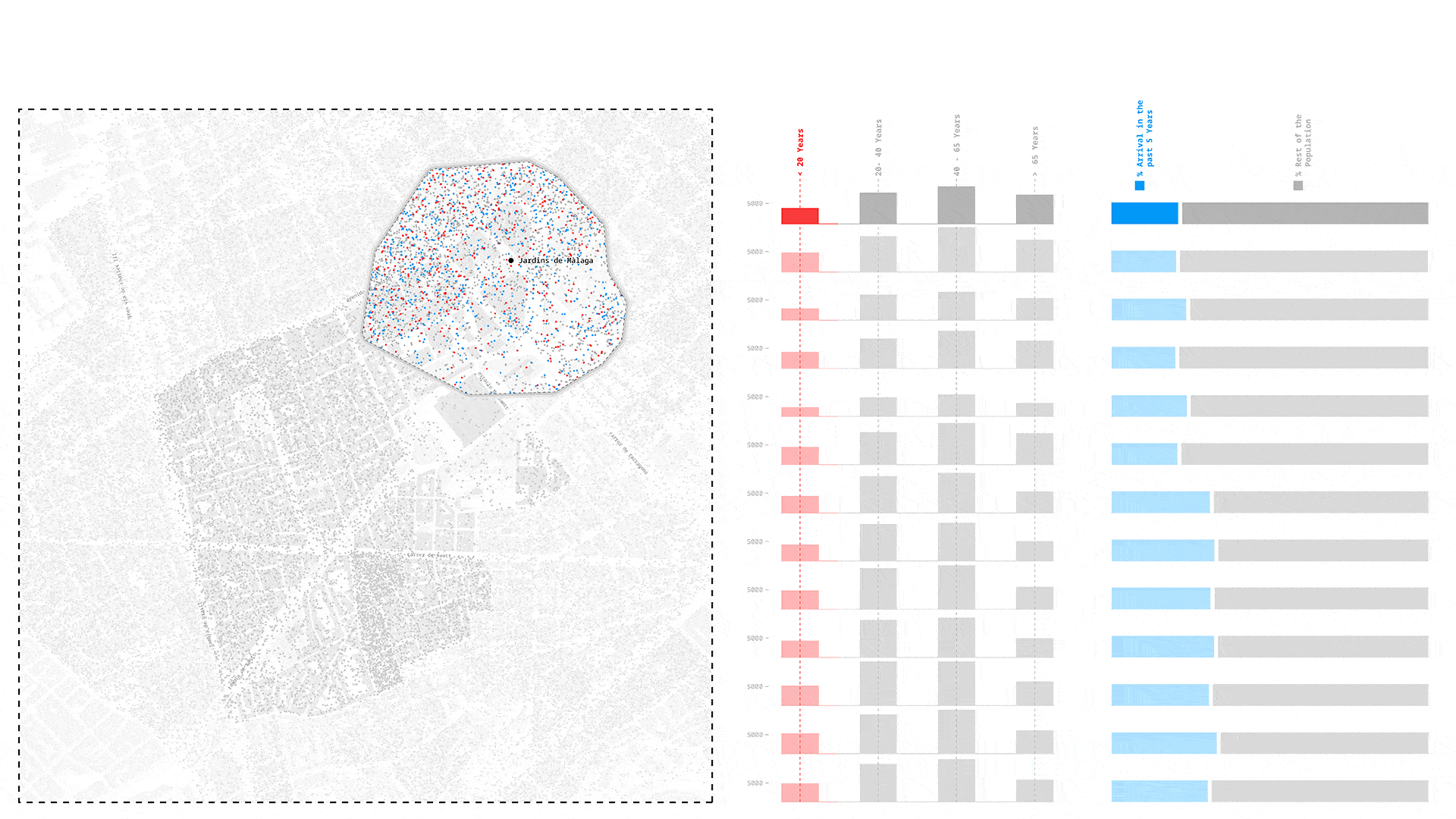
03_DEMOGRAPHIC COMPOSITION
Next, we looked into the neighbors and where are those who might need to be welcomed into local networks. We identified two groups: Still finding their place in the community. With data from the Municipality, we mapped these two groups within 5min walk from each park and used the results to build a profile with the proportion of newcomers and age composition near each park.
04_EMOTIONS OF THE PUBLIC
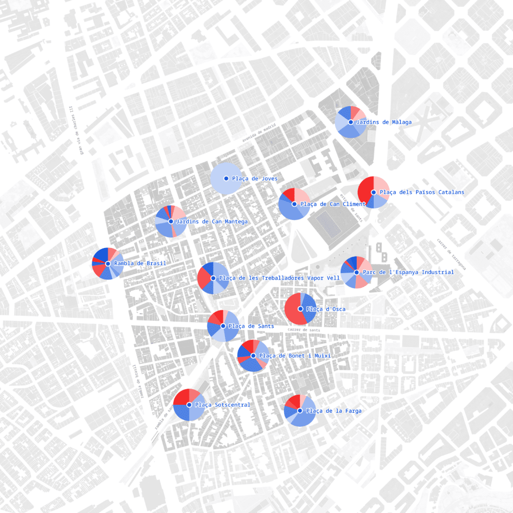
We then wanted to capture perceptions of Sants residents, how do they feel in their public spaces?

We started with the twelve public spaces we previously identified in Sants, and scraped 140 google places reviews, limited by Google API restrictions. We wanted more first person evidence and also to ground truth what we were collecting online, so we conducted 81 interviews on-site.
We fed the reviews and interviews into an AI model to extract relevant keywords of the sentiments of the spaces and different activities happening in the space. From these keywords, we remapped the activities and sentiments and asked the NLM model to identify the keywords that were relevant for each plaza. From these, we can see different characterizations for each plaza. In general, we found a diversity of activities for the public spaces, which were broadly well-liked and well-used.


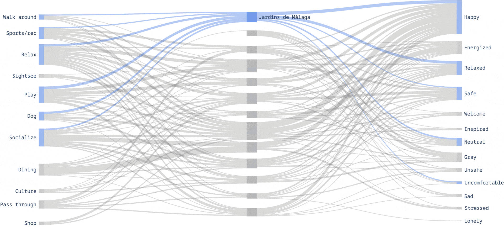
We took the sentiments and categorized them into positive and negative feelings, and saw how the different plazas compare. We also compared these to the images we took of these spaces, and saw how they matched our own experiences there.
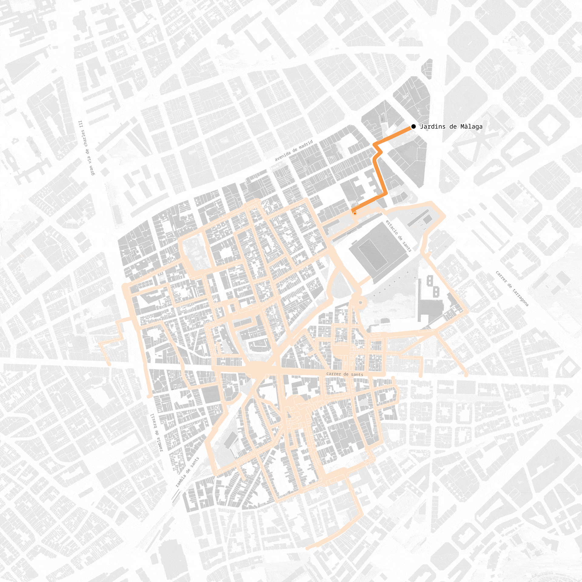
05_ SITE SELECTION: PLAZA SOTSCENTRAL-NOU PARC CENTRAL
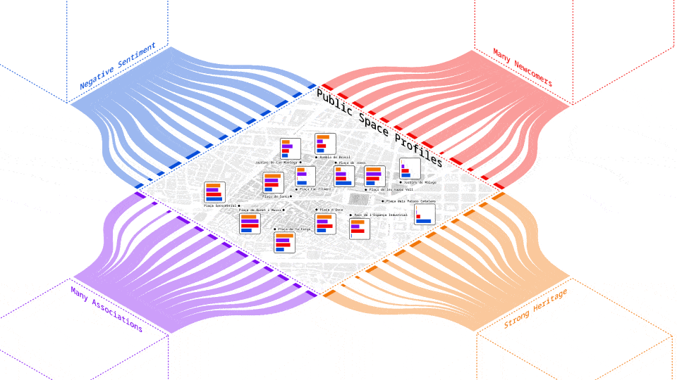
In view of our design objective it meant, we were looking for a public space with: strong concentration of heritage places, a high density of surrounding associations and a space in proximity to the home of many newcomers. Getting a sense of the negative feelings was important, because when thinking about our intervention, we wanted to prioritize areas where there was room for improvement and the opportunity to really transform a space.
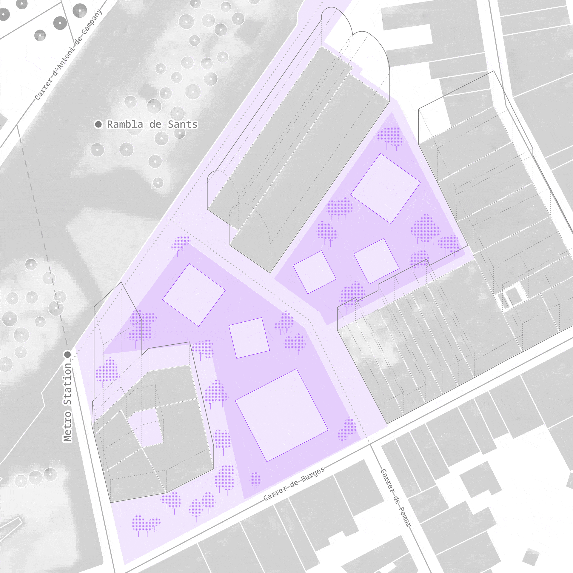
A brief exercise of urban design math translated into little profile cards for each public space we investigated. From here we are able to make an informed decision on which site to situate our design intervention in being the Placa Sotscentral in southern Sants.
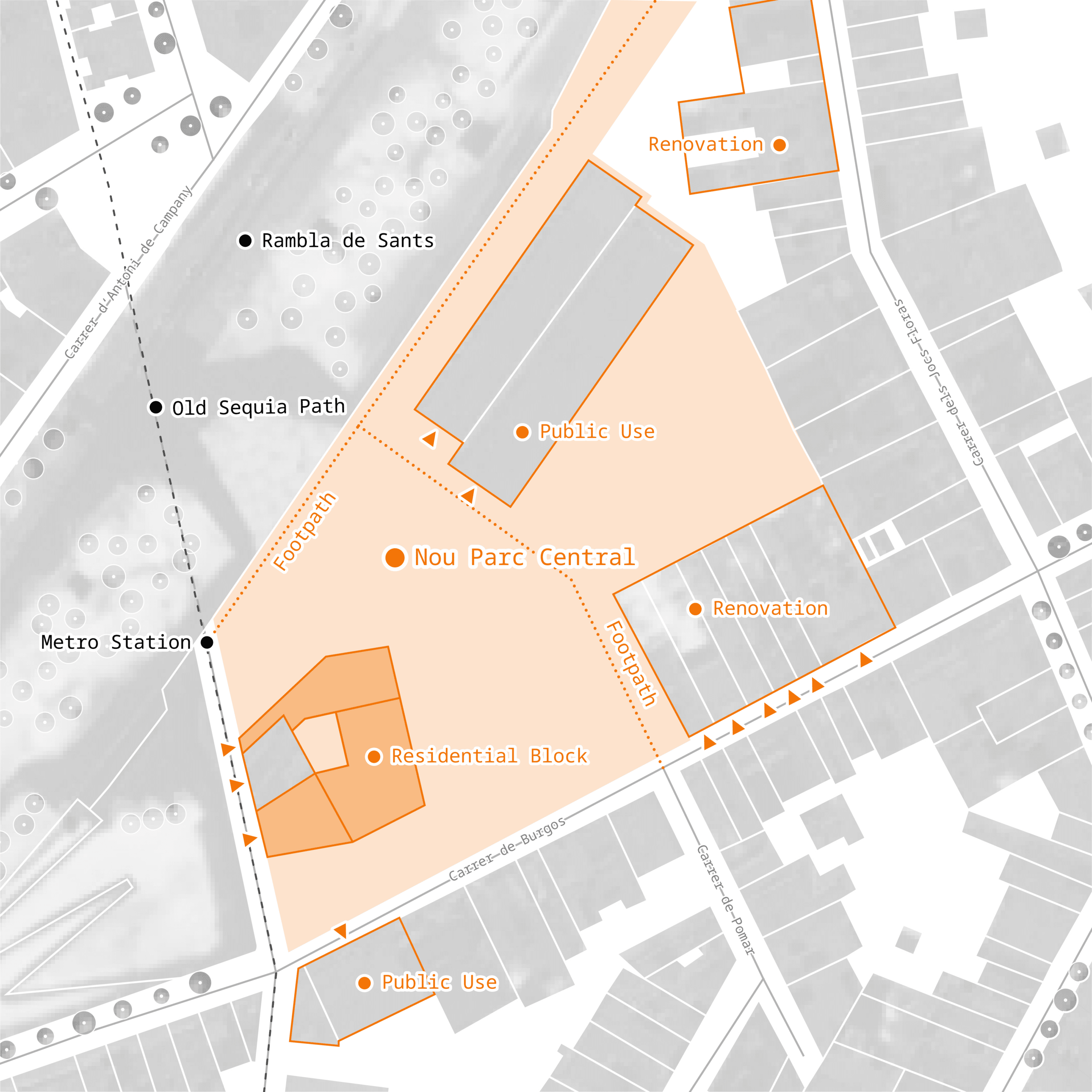
To contextualize, the site is next to La Rambla de Sants and the Mercat Nou metro station. It’s a large, undeveloped area with two buildings linked to Sants’ heritage, the former Sotscentral del Ferrocarril, which once connected Sants and Sant Martí and is now vacant. The other is a residential building with a significant mural that reflects the area’s agricultural past. Additionally, through our mapping of the agricultural history, we identified that an old séquia (irrigation canal) once ran through the site’s street.


Further investigating, we found that the site is part of an ongoing green corridor masterplan extending from Estació de Sants to L’Hospitalet. The urban renewal plan of our specific site repurposes the train depot for public use, adds new housing, and renovates existing buildings. The participatory process of the site began in November, but the park connecting these buildings—Nou Parc Central—hasn’t begun its design yet, so we saw an opportunity for our intervention.
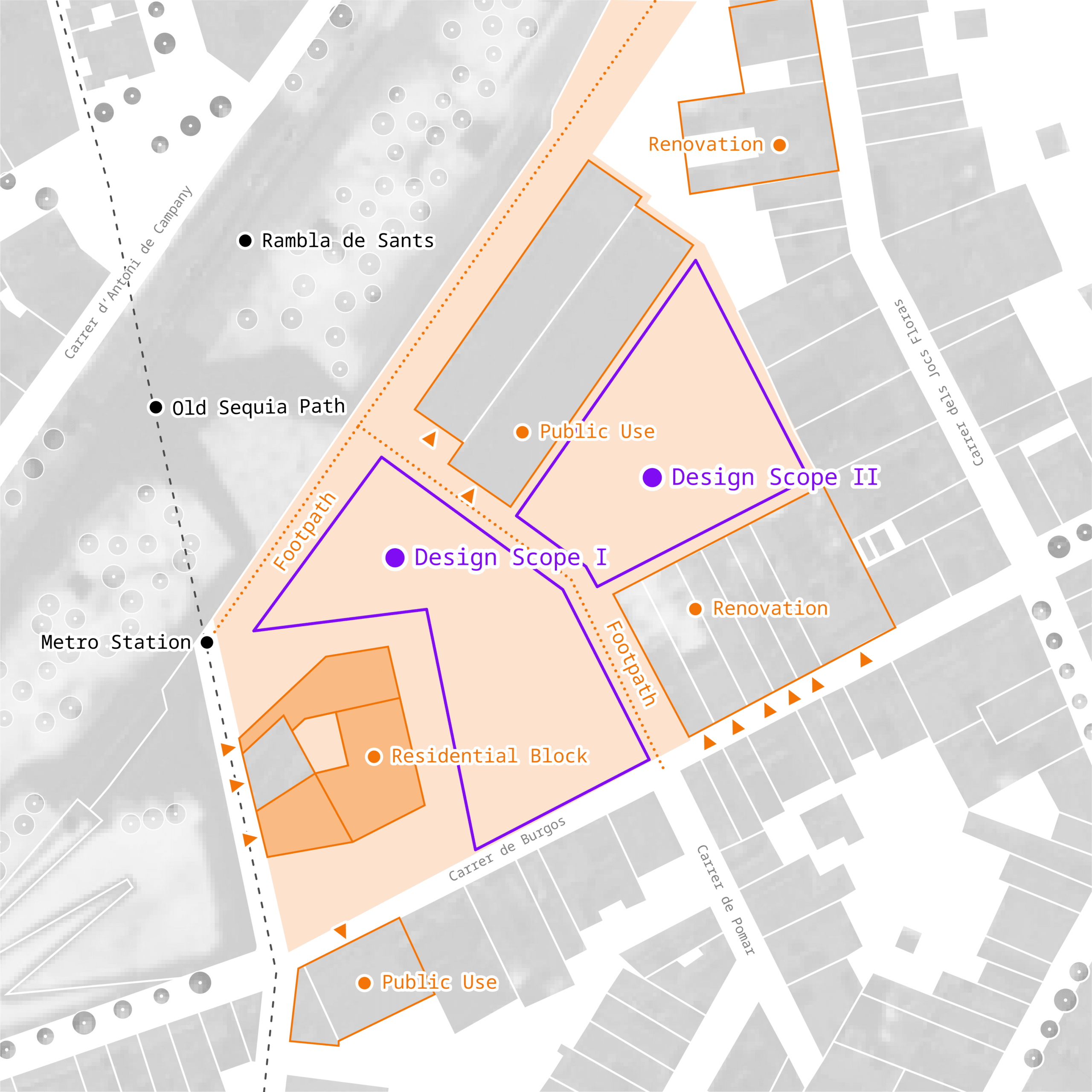
To address our initial objective and recognizing that associations primarily have indoor meeting spaces, we propose an open-air civic hub that: reclaims outdoor space for the community, actively involves local associations, enhances industrial and agricultural heritage, and fosters social interaction between Sants residents and newcomers.
06_EMPOWERING DESIGN
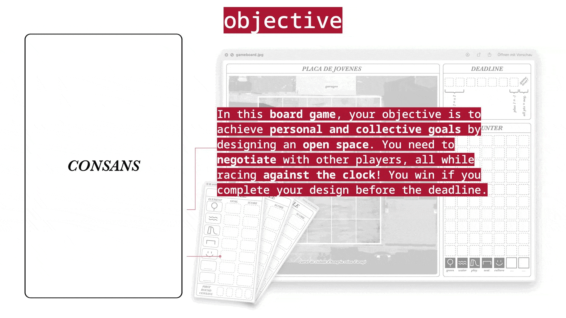
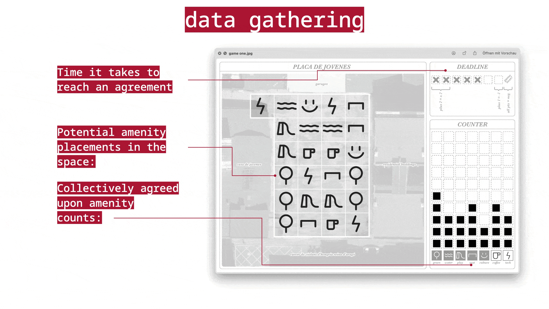
CONSANS GAME
As part of our coursework this term, our team explored how games can be tools within a participatory planning process of a specific site, and developed consans. Consans is a board game for neighbors to come together think about their vision of a space. Players negotiate between their own priorities and those of others in order to get ideas built (on the board). Key elements include the profile cards, where players weight their priorities and even add their own ideas for things to place on the site. There is also the game board, which, at the end of the game, showcases how many of each amenity is collectively agreed upon and a rough idea of their placements. The game does not result in a perfectly democratic design, and so we see the game as an opportunity to generate discussion among players and jumpstart a participatory process. In general, we believe the game and resulting conversations can give planners a sense of how neighbors envision the space: a vague layout and set of programs.
PROCESS
Taking inspiration from our game we came up with a participatory design process, characterized by a sequence – ping pong of design decisions and participant input. It is structure into three main phases:
- Forming: which results in a basic design layout
- Imagining: which views current participant vision through the lens of sants heritage
- Deciding: where the results are filtered into a first design draft
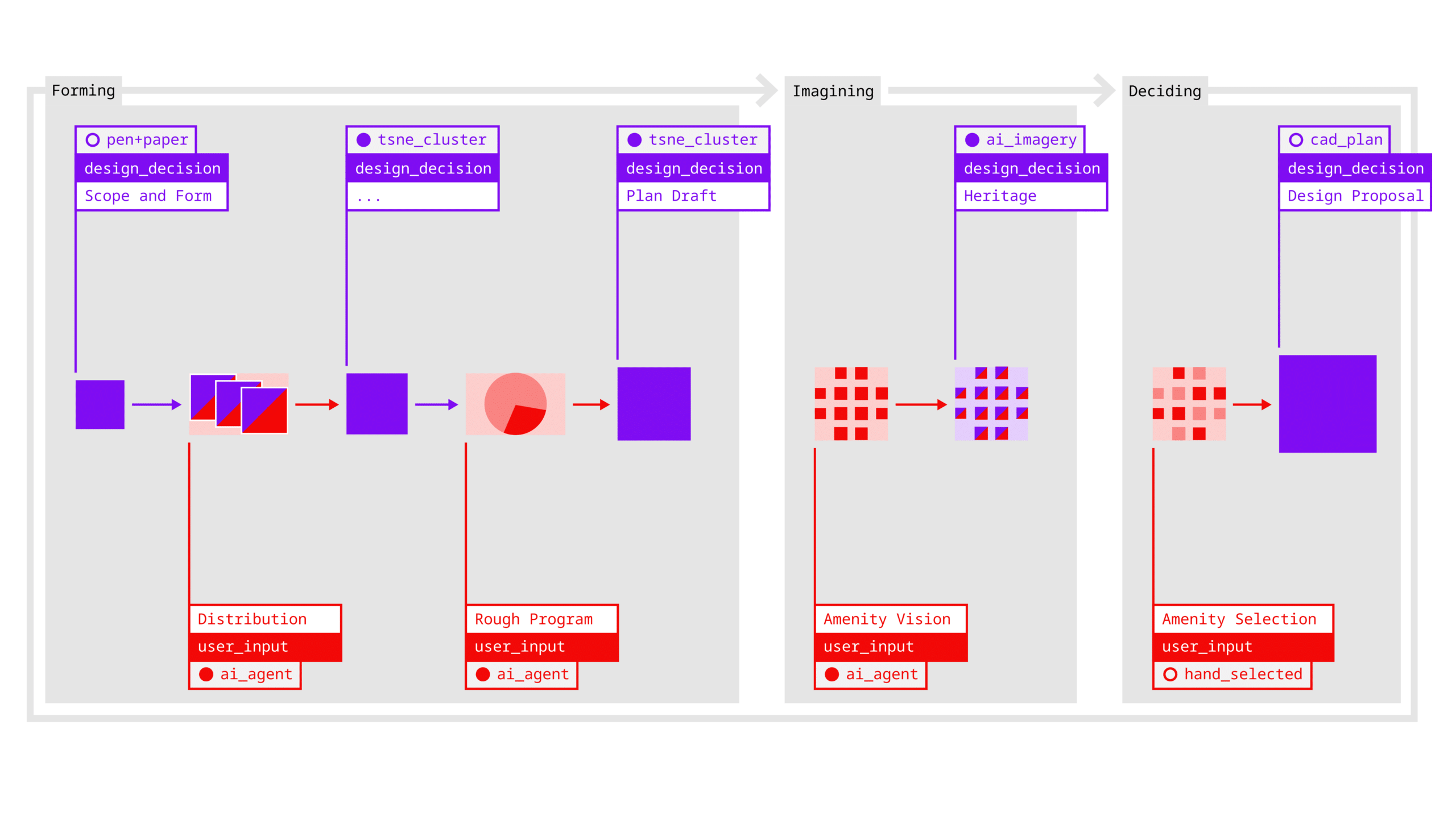
FORMING
Formal Language
As a first design decision we developed some basic, very basic sketches for formal options to be introduced as a starting point for our design. For our test run we selected rectangular shapes as a simple design approach to further work with.

Agents
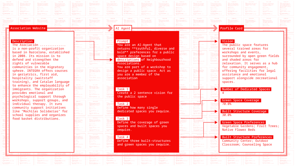
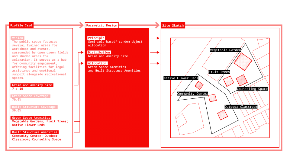
Unfortunately we did not have the time to play our game with 200 people, as such we tried to simulate parts of this process. The cornerstone of this simulation are profiles for preferences of the design for nou Parc central. We created these profile by using the descriptions of the associations as an input and transformed these through Natural Language Processing into a profile card, with several categories, ranging from a general vision to preferences for amenities for the public space.
Input Form
Based on these profile cards we then created variations of this basic pattern. To do so we set up a simple python based parametric design workflow which maps amenity preferences and density into space, simulating the process of sketching in a design workshop.
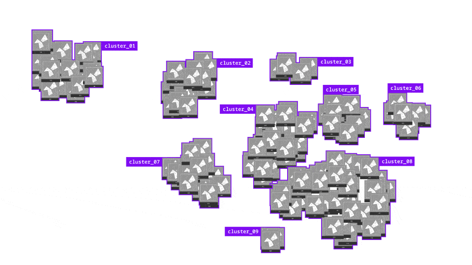
TSNE
This way we create one sketch per association and to analyze the sketches we ran a tsne clustering workflow which compresses multidimensional features into a two dimensional space. This way we were able to visualize the sketches according to their variance and similiarity.
Clustering
We reviewed the cluster and picked two as a basis for our design draft, which we felt featured a good balance.
Sketch
Translated them into a basic formal draft, which further considered circulation and finalized rotation and spacing of the amenity footprints.
IMAGINING
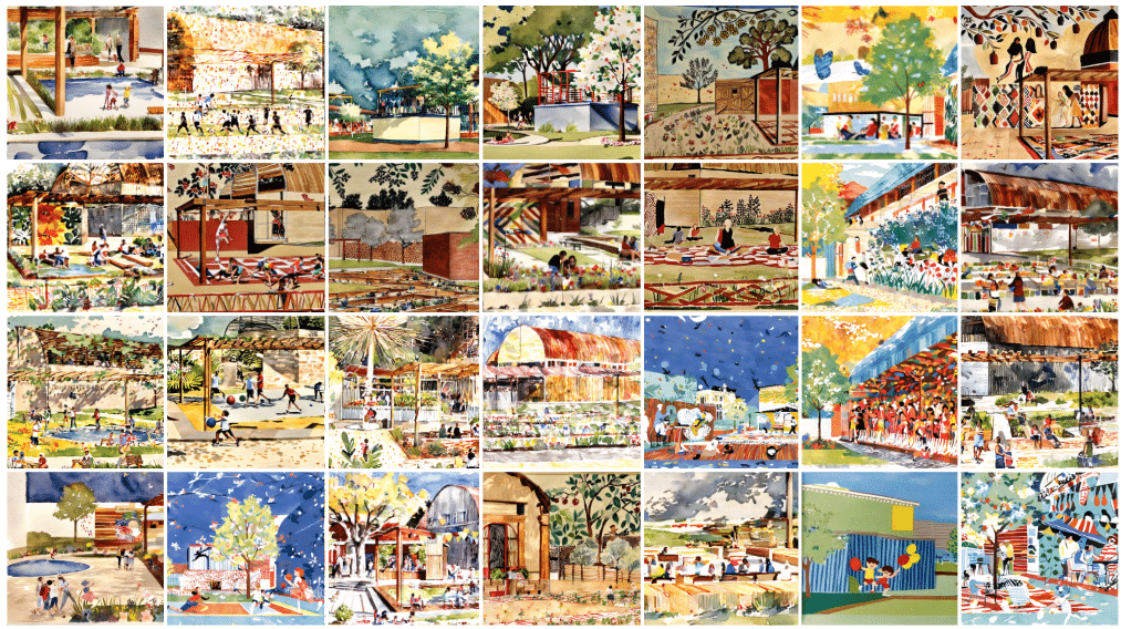
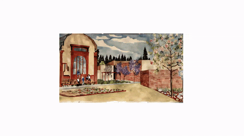
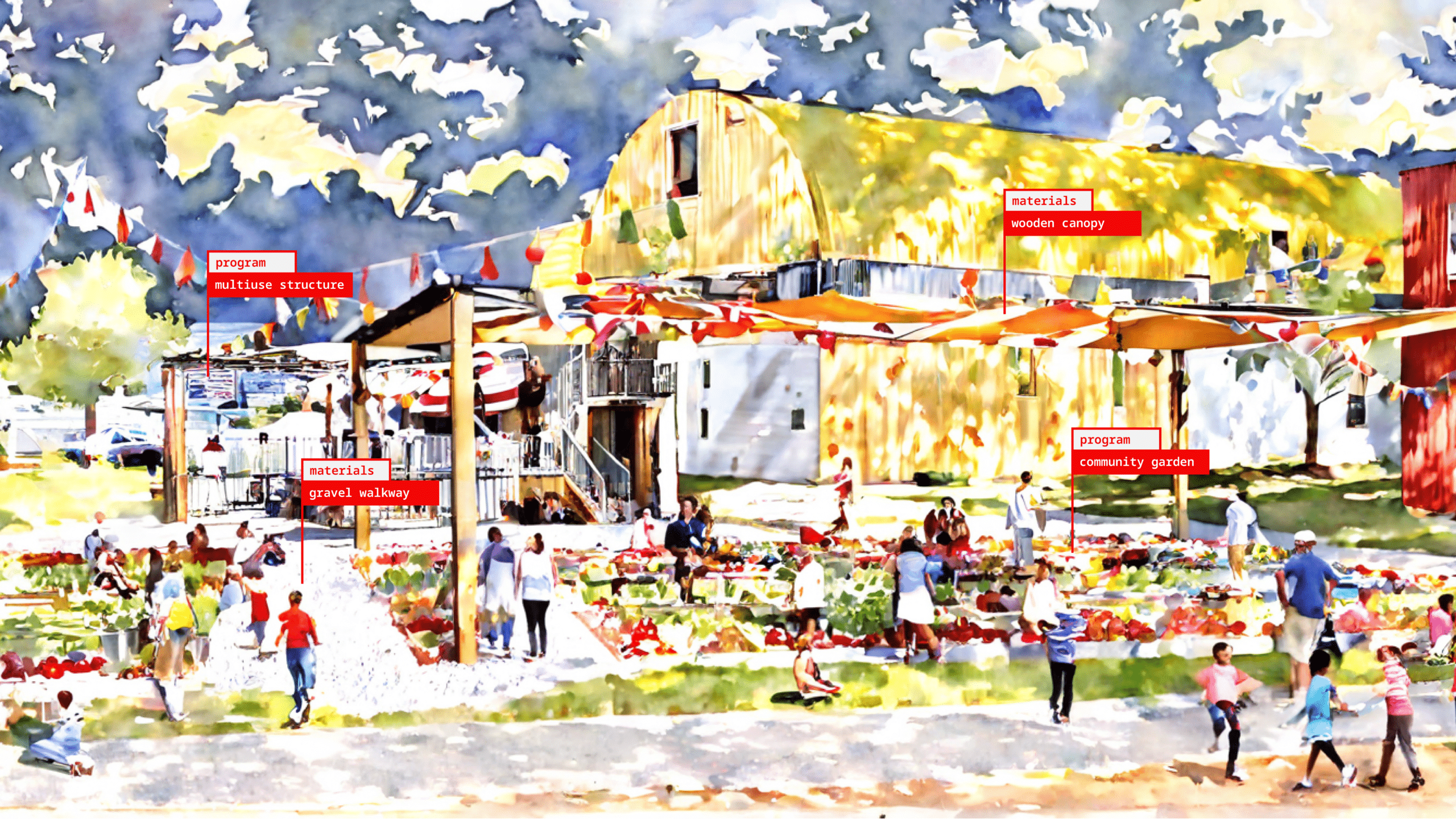
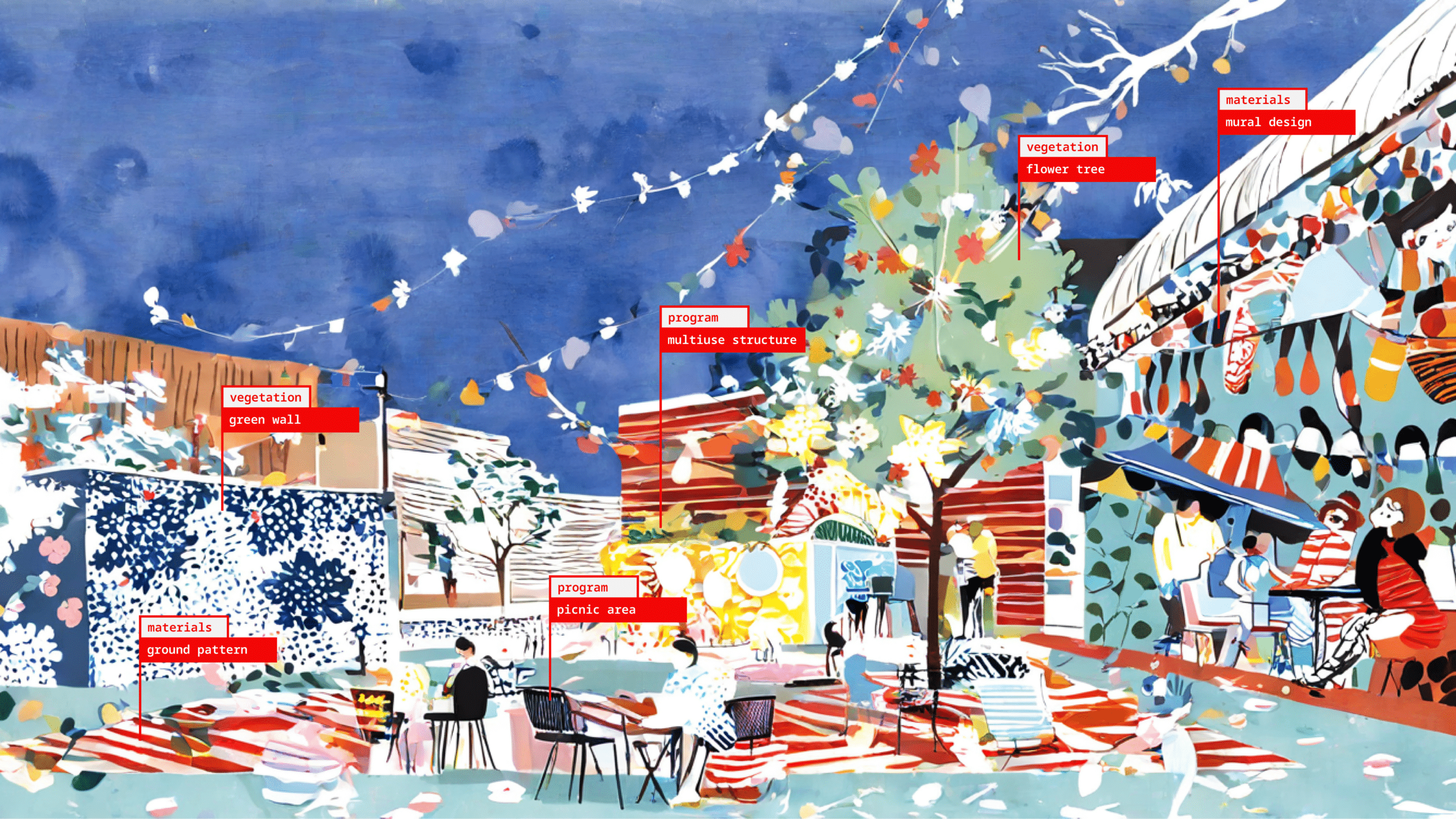
We then moved the imagining phase of the participatory process. We took the final design and created a simple 3D model that we fed into ComfyUI as depth perspectives. We input the Festa de Sants posters, which contain important symbols of Sants heritage, as style references. Additionally, we used the visions of each association profile card and the preferences for green spaces and built structures as a prompt for the image generation.

We tweaked the parameters, experimented with IPAdapter and Controlnet settings, used different masks, and input different latent images, and arrived to a pipeline that generated the best results. Even so, many of the 2000 images we generated came out funny, or crazy. Here we have our selection of the 240 images that most inspired us for the Nou Parc Central.
DECIDING
The third step is decision-making. In a real participatory process, in this stage we would gather people around the generated images, engaging people in conversations on their preferences for the space. Since we conducted this ourselves, we tagged different programs, materials, and vegetation, identifying recurring elements across images. We did our best to align the tags with the preferences expressed in the profile cards.


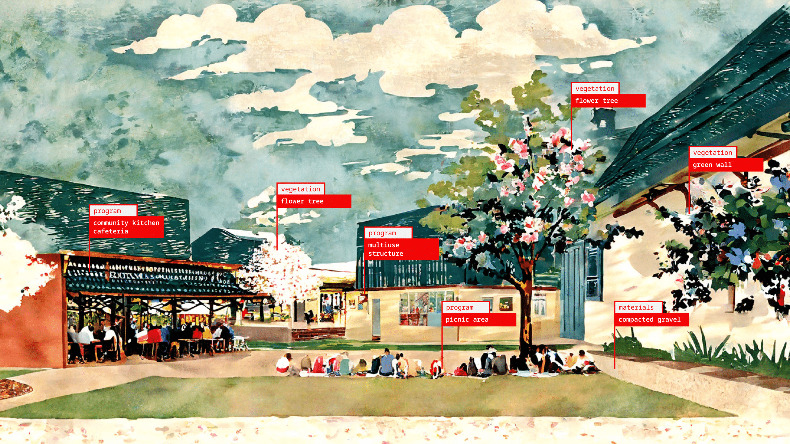
Using these images as a reference and catalyst, we then elaborated the design plan.
- We began by weaving through a reference to the irrigation canal that previously flowed by the site. We envision this as wetland grasses alongside park seating.
- We then placed a multi-activity field, something that many imaginings featured, in the southern corner, easily seen from the street and inviting people to play.
- We placed the Casa Club, multi-purpose structure, in the center of the site. We imagine this as a space that can adapt to the different needs of local associations, transforming from outdoor classroom to bicycle workshop.
- In the northwest site, we placed a wildflower and sensory garden, responding to desires for green space and dedicating a space for many of the flowers that we identified as local symbols from the festa posters.
- Deeper into the site, we placed a community garden, aligning with the visions reflected in the images and profile cards.
- Complementing the garden, we included a community kitchen and café, that could be managed by local associations and designed to support their activities.
- Adjacent to this, a picnic area encourages social bonding through shared meals, reinforcing the plaza’s role as a space for community gathering.