The workshop challenged us to engage with the topic of planetary urbanization through the United Nations Sustainable Development Goals 2030 agenda. We chose to work on the city of Neuquen as it represents an example of a city that is undergoing a fast transition in the context of climate change. Neuquen province has a rich reserve of shale gas which became technically extractable around 2011. The recent global shift from oil to gas means that the city Neuquen expects a temporary population boom while natural gas is the most environmental and economical alternative on the energy market. The projection is however that it will eventually be overtaken by green sources of energy. Neuquen is a provincial capital city in Argentina with a population of 236.232 people, a population growth of 1,89% and a surface of 120 km2. It is located at the easternmost edge of the homonymous province and is situated at the confluence of Río Neuquén & Río Limay, which separates it from the neighbouring province of Río Negro; together with smaller towns from both provinces it forms the Plottier-Neuquén-Cipolletti urban agglomerate.
Lesson 1: The advantage of flexible plans
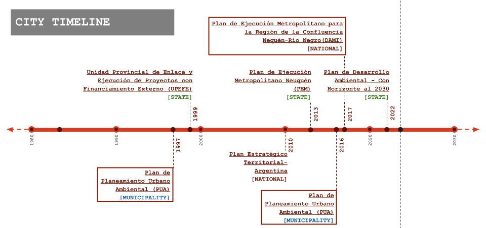
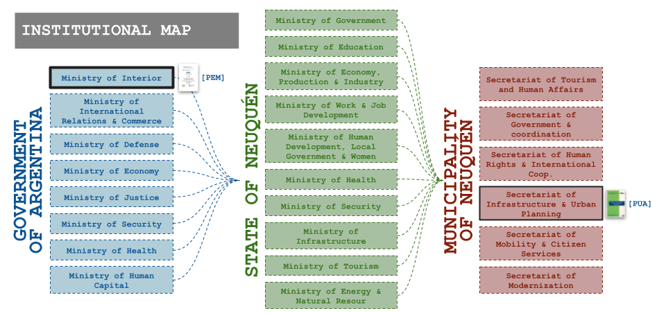
The government of Argentina consists of a federal system that has 3 levels of hierarchy : National level, State level and Municipal Level. Each layer governs over a different scale of territory and has a certain amount of autonomy. In the specific case of Neuquén this has led to a lack of communication between the different hierarchies, and as a result, to different proposals for urbanization plans over the years, that have a focus on projects instead of plans and that lack coherence and a holistic view between each other. The municipality is run on a spatial plan from 1997 that categorizes different spaces based on geographical and functional characteristics. The functional zoning of the city has evolved over time and has facilitated a number of provincial strategies (touristic and ecological) within its spatial framework. Since 2017 the UN 2030 SDG agenda has been making an impact on the types of projects that are conducted within the context of the spatial setup of the city.
This disconnect between the administrations of the different layers of government and their proposals is troublesome because, even though the municipal level plan and urban code is flexible enough to allow for diverse initiatives, the lack of dialogue about the objectives and prioritization leads to an inefficient use of the limited resources (both in terms of capital, and human resources). This has the effect of hindering the progress of the proposals and thus never fully accomplishing the goals set up in the beginning.
Understanding this main issue that the planning of the city of Neuquén has, we believe that it’s important not only to strengthen the communication between all levels of governments but also to make this agreement more transparent on the corresponding official documents so that external parties (such as ourselves) can obtain a clearer overview of the spatial strategies at hand.
Lesson 2: SDGs trickle down in local administrations
Looking at the documents for the urbanization of Neuquén through the different levels of governance, it became apparent that although said documents didn’t reference the UN’s 2030 vision and its SDGs (due to being unaware of them, or due to the SDGs not existing by that time), many of the objectives and preoccupations were the same or could be translated easily to the SDGs. Since 2017 we see a clear shift towards a tone that acknowledges and addresses climate change as a major topic of concern. We believe that one of the most important effects of the SDGs, rather than homogenizing the development of the entire world, could be to bring discussions to the table.
Lesson 3: The ambition of globally comparable data
The ambitions of the social development goals are measured through so-called indicators. Usually the measurement of these indicators is done at the national level, for the sake of feasibility. This however creates a mismatch between the high ambition of the SDG targets and the availability of local data. Especially in peripherally located areas such as Neuquen, or in cities where it is economically unfeasible to gather the required data through censal gathering, the traceability of the SDG indicators becomes very vague indeed.
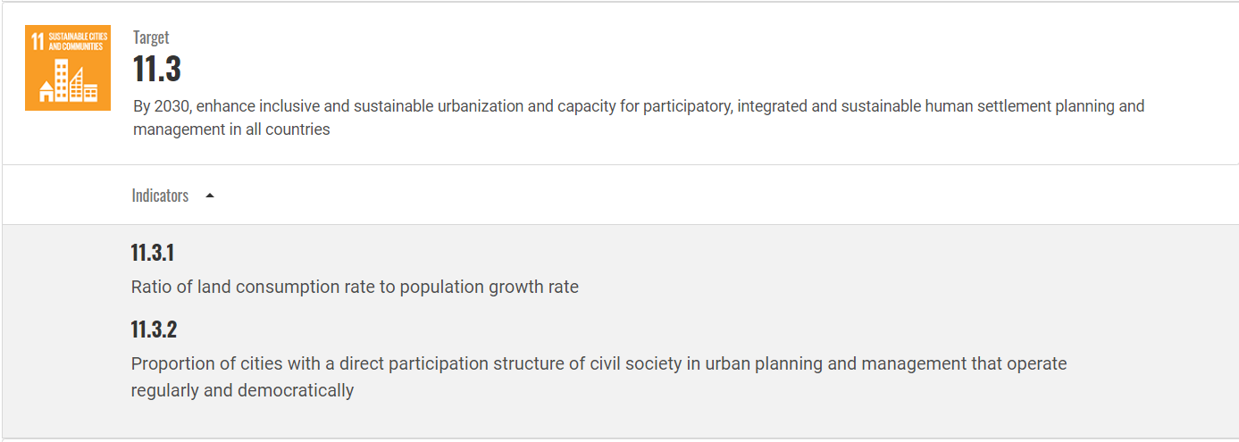
We will illustrate this with the example of SDG target 11.3: In order to measure the indicators through local data, the municipality would need to trace the amount of built land and the population. While these may seem like feasible objectives for trained GIS professionals, the reality is that the latest population data in Neuquen at the granularity of the neighbourhood stems from 2010 and that the and that the most recent plans of the city are not published in up to date software. This means that in reality, tracing this SDG requires a monumental effort of modernisation of the public office. From our experience in Neuquen and from the work of our colleagues in other cities around the global south we conclude that the ability of public officials is not and will not reach the technical level required to measure these indicators before 2030.
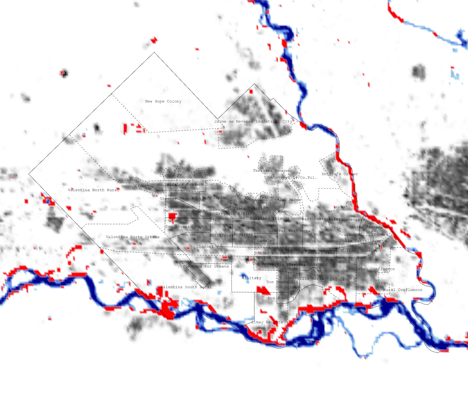
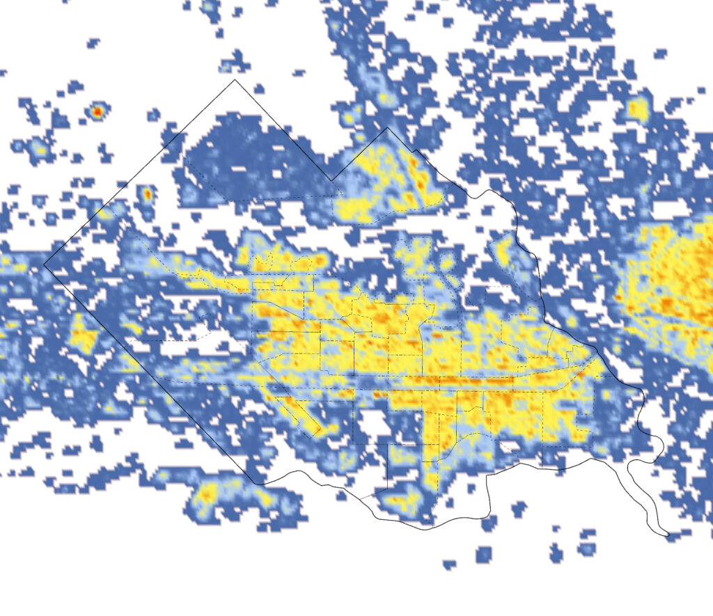
We do however see an alternative approach. While mapping the SDGs in Neuquen we found that we relied heavily on satellite imagery and remote sensing. The advantages are clear: the datasets are globally available and therefore globally comparable. The granularity can reach a pixel size of 10×10 meters which is superior to most local census datasets. The fact that the data is gathered into a single global data source means that computational experts can run complex analysis, expecting comparable results from any location on the planet. Examples of this can be: A universal measurement of global expansion, a universal methodology for population estimates (adjusted with reliable and up to date censal data) or a universal definition of informal housing (defined through machine learning algorithms). Our suggestion would therefore be to adjust the indicators so that they can be monitored centrally by the united nations instead of locally.