The MaCAD is a unique online programme training a new generation of architects, engineers and designers ready to develop skills into the latest softwares, computational tools, BIM technologies and AI towards innovation for the Architecture, Engineering and Construction (AEC) industry.

Filters
Course

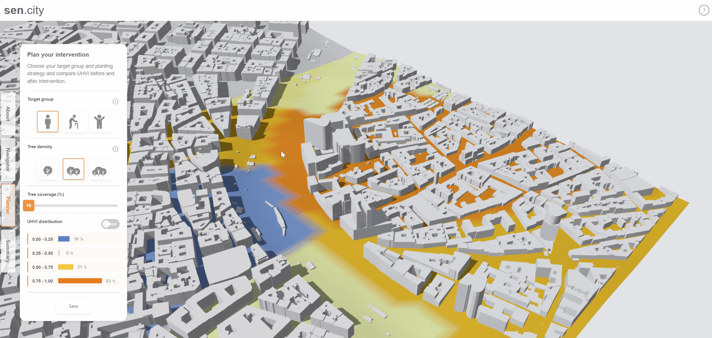
Web-Based Bitmap Terrain Generator

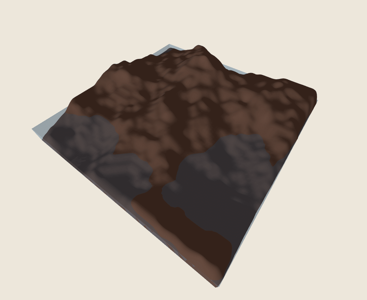
In the Cloud-Based Data Management seminar, our final project explored how parametric design tools can move beyond the desktop and become accessible through the web. The course focused on transforming Grasshopper definitions into web-based applications using Rhino.Compute, Vue, and web visualization workflows, with the goal of making computational design more accessible to end users. This … Read more

sen.city – Sense urban heat and plant cooler futures for everyone

Cities are warming rapidly, and dense urban centers feel it the most — especially areas with little shade or vegetation. Heat doesn’t affect everyone equally: groups like the elderly, youth, and people with health conditions are far more vulnerable. Problem Statement Most existing tools focus on UTCI, the Universal Thermal Climate Index. It measures how … Read more

Architecture as Living Matter: Turning Data into Geometry

Introduction Hyperbuilding 03 In our project, the building is conceived not as an isolated object, but as a vertical living tissue within the broader human organism of the “Vertical Machine”. Much like a network of functional cells, it sustains life, maintains environmental balance, and coordinates with the system’s “lungs” and “heart.” This biological metaphor guided … Read more

Beyond Construction: BIM as a World-Building Tool for Real-Time Game Engines

Abstract This research investigates how Building Information Modeling (BIM) can be leveraged to generate structured and meaningful architectural environments for architectural visualization, video games, and animated films. It explores workflows between BIM tools and real-time game engines, focusing on the transfer and preservation of spatial logic and metadata. The study aims to demonstrate how BIM-based … Read more

Aquamines

Inhabiting Ice Cavities under the Martian Surface Introduction – The Idea For the first settlers on Mars, we have envisioned a colony of Aqua-Miners with the primary task of harvesting water as a resource from the ice beneath Mars’ surface, storing it and recycling it for sustainable use. Our approach to this problem has been … Read more

Genius Loci

View some of the collected data here: Street Types and Property Information Genius Loci was inspired by the work the of Sarah Williams in her book ‘Data action – Using data for public good’. In today’s data-driven world, the use of data has become increasingly pervasive, shaping various aspects of our lives from policymaking to … Read more

NOISENSE

NOISENSE emerges as a dynamic tool that facilitates the visualization of otherwise visually imperceptible phenomena within spaces. Through sound simulation and virtual prototyping techniques, NOISENSE aims to go beyond the limitations of human auditory perception, thereby enabling the visualization and replication of sound atmospheres. By conceptualizing sound as a spatial field, the online app allows … Read more