
Mobility when Tourism outgrows the City
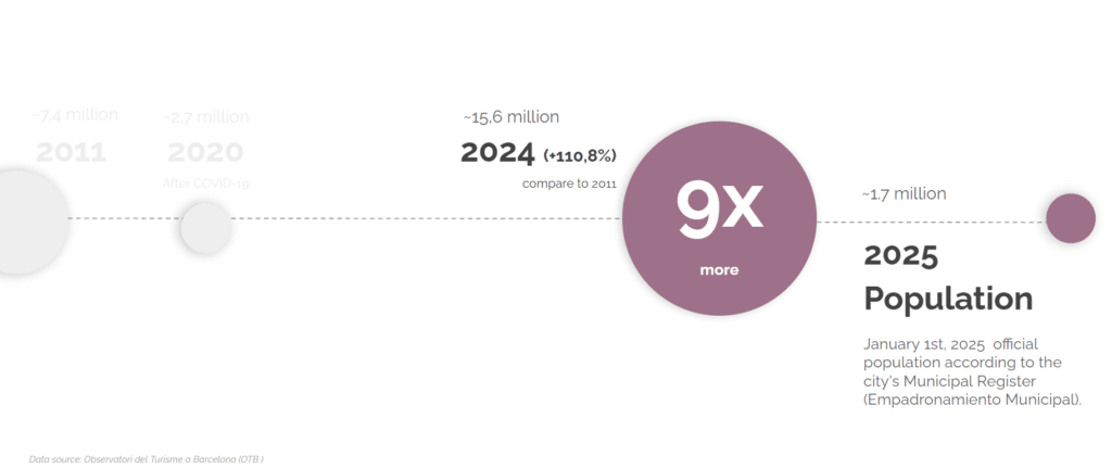
Barcelona is the 10th most visited city in the world. In 2024, it received approximately 15.6 million tourists – nearly nine times its resident population of 1.7 million.
The issue is not tourism itself. Barcelona’s economy depends on it, and the city’s cultural richness is inseparable from its global appeal. The issue is unmanaged movement – visitors arriving with little guidance, diffusing uncoordinated through the narrowest residential streets, saturating public space at the very hours and places that residents depend on most.
Looking at this reality, our project began with a question:
How can mobility systems support both
residents and visitors without
compromising either group’s
experience of the city?
Rather than viewing tourism as a problem to eliminate, we approached it as a condition that cities must learn to manage more effectively.
Reading the Urban Grid
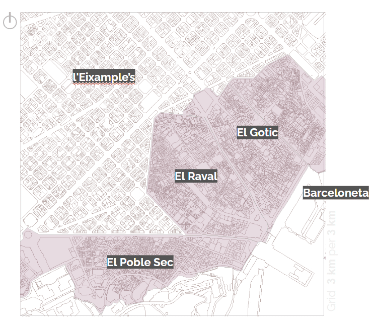
Our study focused on the transition between two distinct urban fabrics in central Barcelona. This transition creates a unique mobility challenge.
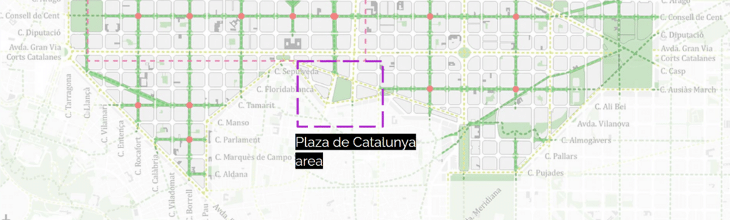
The study area spans a 3km × 3km grid centred on the transition between two fundamentally different urban morphologies: Ciutat Vella – comprising El Gòtic, El Raval, Sant Pere, and Barceloneta and the rational, orthogonal Cerdà grid of l’Eixample.
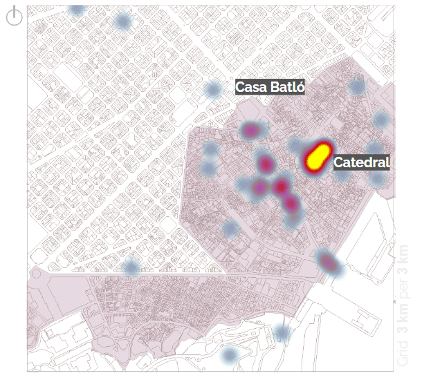
As illustrated in the map below, the highest concentration of tourist attractions – in our study area – is located within Barcelona’s historic medieval grid. This spatial concentration attracts a continuous flow of visitors throughout the day and night, generating intense pedestrian movement and prolonged occupation of public space. Unlike residents, who tend to move faster between daily destinations, visitors often walk at slower speeds, stop frequently for sightseeing, photography, orientation, and wayfinding. As a result, these areas experience higher levels of pedestrian congestion and spatial friction, particularly in narrow streets and public spaces that were not originally designed to accommodate contemporary tourism volumes.
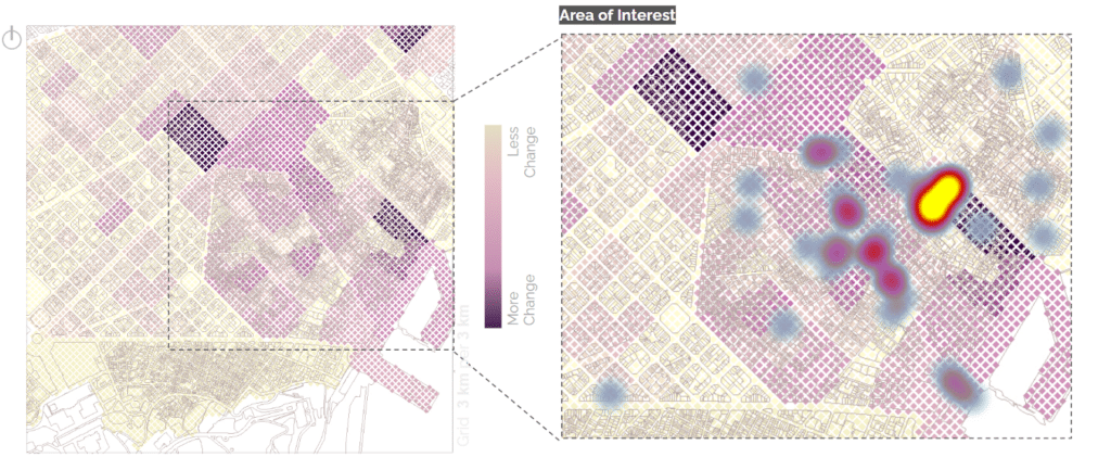
Our analysis revealed that areas with the highest concentration of tourist attractions also correspond to areas experiencing the highest urban transformation. As visitor numbers continue to grow, historic neighborhoods increasingly adapt their services, public spaces, and economic activities to temporary users rather than permanent residents.
This process gradually alters the social composition of the city. Housing becomes more expensive, local businesses are replaced by visitor-oriented services, and everyday residential life becomes harder to sustain.
In this context, mobility is not simply a transportation issue. It becomes an indicator of a broader imbalance between the needs of residents and the demands generated by tourism.
Two different patterns of behavior

Locals:
Depend on mobility systems for their daily routines and economic activities. They need mobility to access to services and amenities, logistics to ensure goods and deliveries arrive on schedule.
Mobility directly impacts their quality of life, productivity, and access to opportunities.
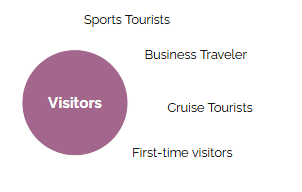
Visitors:
Prioritize convenience, comfort, and easy access to the city’s main attractions or appointments.
Walk at slower speeds, stop frequently for sightseeing, photography, orientation, and wayfinding
They need flexible schedules and intuitive routes to navigate in unfamiliar environments.
Our Position
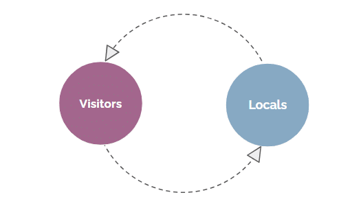
Locals and visitors often overlap mobility dynamics, they operate according to different temporalities and priorities, such as speed, timing and comfort.
Constraints – How can Public Transport networks at grid edges streamline tourist wayfinding to reduce visitor congestion and therefore improve residents’ daily mobility?
Our Findings
Through spatial analysis, we identified a recurring pattern: the highest mobility pressures emerge not inside the historic core itself, but at its edges.
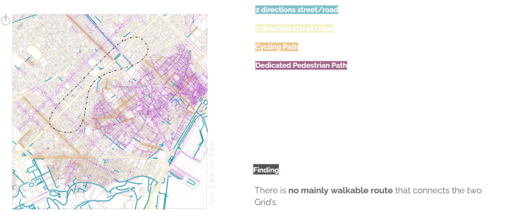
Our infrastructure analysis reveals the absence of a continuous, predominantly pedestrian route linking the Eixample grid to the historic center. Instead, the medieval city is enclosed by major arterial avenues designed to prioritize vehicular movement, creating both a physical and perceptual barrier between the two urban systems.
Within the historic grid, the street network is characterized by narrow, irregular, and predominantly one-way streets, where pedestrians, cyclists, service vehicles, and deliveries share the same limited public space. While this urban morphology contributes to the area’s cultural identity, it was never designed to accommodate contemporary mobility demands.
As a result, mobility tensions emerge not only within the historic center itself, but especially at its edges, where large numbers of visitors transition between metropolitan transport networks and the medieval urban fabric. These boundary conditions become critical interfaces where the needs of residents, commuters, and tourists increasingly overlap.
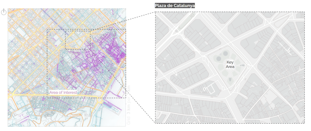
Why Plaza de Catalunya?
Our analysis identified Plaza de Catalunya as the key area for intervention, as it represents one of Barcelona’s most important interfaces between residents, commuters, and visitors. Located at the transition between the Eixample grid and the historic center, the square concentrates multiple mobility systems and urban functions within a single space.
Simultaneously functions
- A metropolitan transit hub;
- A gateway between Eixample and Ciutat Vella;
- A connection point for metro, rail, airport buses, and regional transport;
- A commercial center surrounded by intense pedestrian activit;
- A key node within Barcelona’s Superilles (Green Corridors) pedestrian-oriented;
Rather than treating this concentration as a problem, we reframed it as an opportunity.
Replicability
The Superilles strategy aims to reorganize Barcelona’s mobility network by reducing through-traffic, prioritizing pedestrians, expanding green corridors, and creating more liveable public spaces. Rather than functioning as isolated interventions, Superilles establish a citywide network of pedestrian-oriented corridors and mobility nodes.
We therefore propose Plaza de Catalunya as a pilot intervention within the Superilles framework. The objective is not only to improve mobility conditions in this specific location, but also to develop a replicable methodology for identifying and transforming similar urban interfaces across Barcelona.
By mapping the Superilles network, other nodes with comparable characteristics can be identified: locations where metropolitan transport converges with pedestrianized districts, where visitor and resident flows overlap, and where public space experiences high levels of pressure. These interface conditions create opportunities to replicate the same layered strategy, combining wayfinding, multimodal integration, micro-mobility, and public realm improvements.
In this sense, Plaza de Catalunya becomes more than a site-specific intervention. It serves as a prototype for a broader network of mobility gateways capable of balancing tourism, local accessibility, and public space quality throughout Barcelona.
Some of the locations previously mapped by the group that present similar characteristics and could serve as future pilot areas for replication include:
- Estació del Nord / Arc de Triomf
- Estació de França
- Plaça d’Espanya
- Sagrada Família
- Drassanes / Portal de la Pau
- Barceloneta Station
- Glòries Interchange
- Sant Andreu Arenal
- La Sagrera Mobility Hub
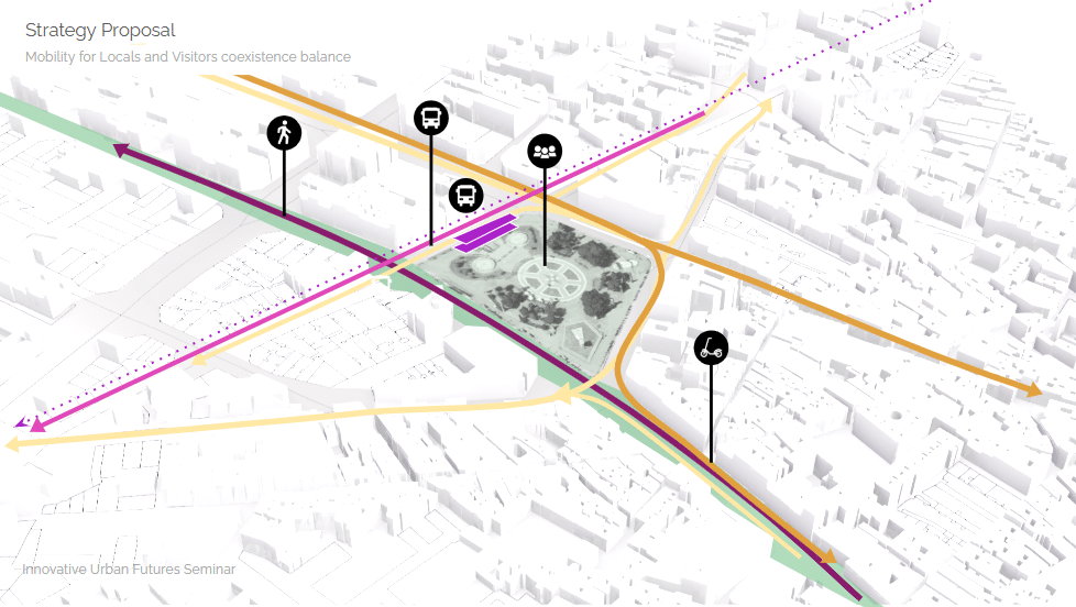
Mobility Strategies
To address the mobility tensions identified at the interface between the Eixample and the historic center, we developed a set of complementary strategies centered on Plaça de Catalunya. Rather than proposing a single intervention, the project introduces a layered mobility system capable of responding to the different needs of residents and visitors.
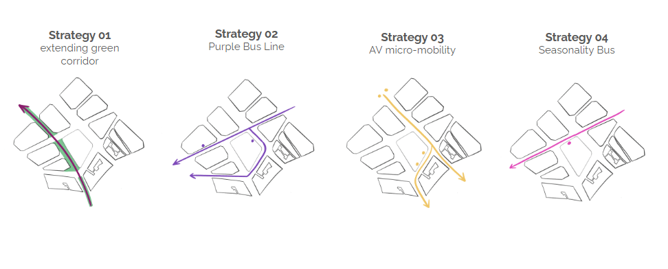
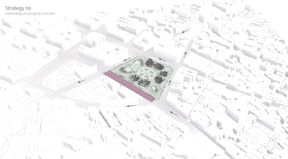
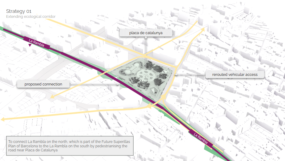
The first strategy focuses on extending Barcelona’s ecological and pedestrian corridors through Plaça de Catalunya, strengthening the continuity between existing and future Superilles. By prioritizing walkability and public space quality, the intervention transforms the square into a more accessible and people-oriented urban gateway.
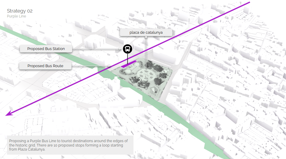
The second strategy introduces a dedicated tourist mobility loop connecting major attractions located around the edges of the historic center. By organizing visitor flows before they enter the medieval fabric, the system reduces unnecessary pressure on narrow streets while improving orientation and accessibility for first-time visitors.
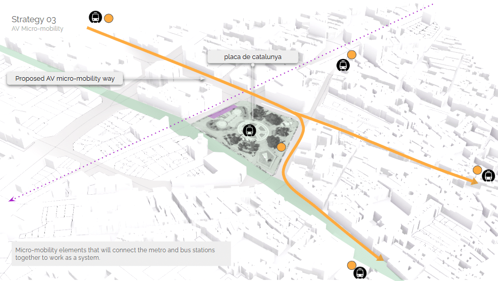
The third strategy incorporates micro-mobility connections that bridge metro stations, bus stops, and key destinations. These short-distance mobility services create a seamless multimodal experience and improve last-mile accessibility without increasing vehicular traffic within sensitive historic areas.
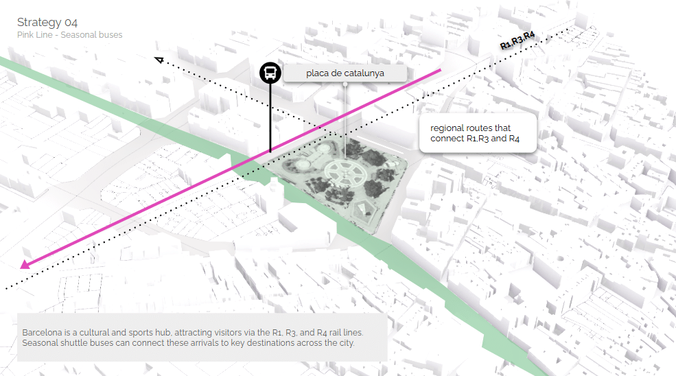
Finally, a seasonal mobility layer responds to fluctuations in tourism demand throughout the year. Temporary shuttle services can be deployed during peak periods, major events, or sports activities, providing additional capacity while maintaining the efficiency of the everyday mobility network.
Together, these strategies reposition Plaça de Catalunya as a multimodal interface that organizes movement, improves wayfinding, and balances the coexistence of residents and visitors.
Conclusion
As tourism continues to reshape cities worldwide, mobility challenges increasingly emerge at the intersection of historic urban fabrics, transport infrastructure, and public space. Barcelona provides a clear example of these dynamics, where growing visitor numbers place additional pressure on areas originally designed for a very different scale of movement.
Through spatial analysis, our research identified Plaza de Catalunya as a critical interface where multiple mobility systems, urban functions, and user groups converge. Rather than viewing this concentration as a problem, we approached it as an opportunity to reorganize flows and improve the relationship between visitors and residents.
More importantly, the project proposes a replicable methodology. By identifying strategic interface nodes within Barcelona’s Superilles network, similar interventions can be implemented in other locations where transport hubs, tourism pressures, and local daily life overlap. In this sense, Plaza de Catalunya is not only a site for intervention but also a prototype for a broader network of mobility gateways capable of supporting a more balanced, accessible, and resilient city.
