
This project explores how power operates spatially through counter-cartography and autoethnography in Poblenou, Barcelona. Combining observation, mapping, and self-tracking, the research examines how infrastructure, urban objects, rules, and rhythms shape behavior, movement, and perception. Benches, pedestrian streets, and smoking practices reveal how freedom, restriction, and permission are unevenly distributed. Findings show that movement is widely enabled while rest is conditionally granted.
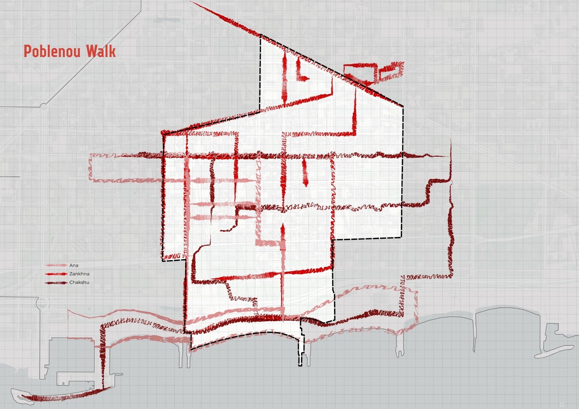
To begin the project, the three researchers walked Poblenou together. The same streets, the same neighbourhood, the same day — but three different bodies, three different backgrounds, three different things noticed. The walk was the first data collection exercise, though it didn’t feel like one at the time. It produced the raw material that each would later take in a completely different direction.
But before setting foot in Poblenou, the neighbourhood was approached through data as well. Street names and their gendered history, land use, noise levels, public infrastructure, and temporality were studied as a preliminary reading of how power operates in the area. This wasn’t fieldwork yet — it was a way of building a spatial understanding of the site before the body encountered it, identifying where to look and what questions to bring.
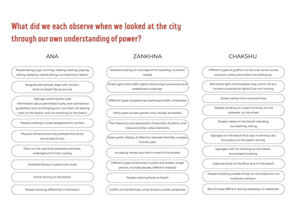
Looking at the same city through three different understandings of power, the observations diverged immediately.
Ana was watching bodies — what they were doing, where they were permitted to do it, and how the beach and the street produced different behavioural rules.
Zankhna was watching objects and infrastructure — benches, pathways, gates, the frequency and placement of things that regulate movement and rest.
Chakshu was watching actions and their contradictions — signs that said no smoking next to people smoking, police on a beach where cars were prohibited, runners crossing red lights when no car was coming.
Three bodies, same neighbourhood, three completely different cities.
Emerging Patterns
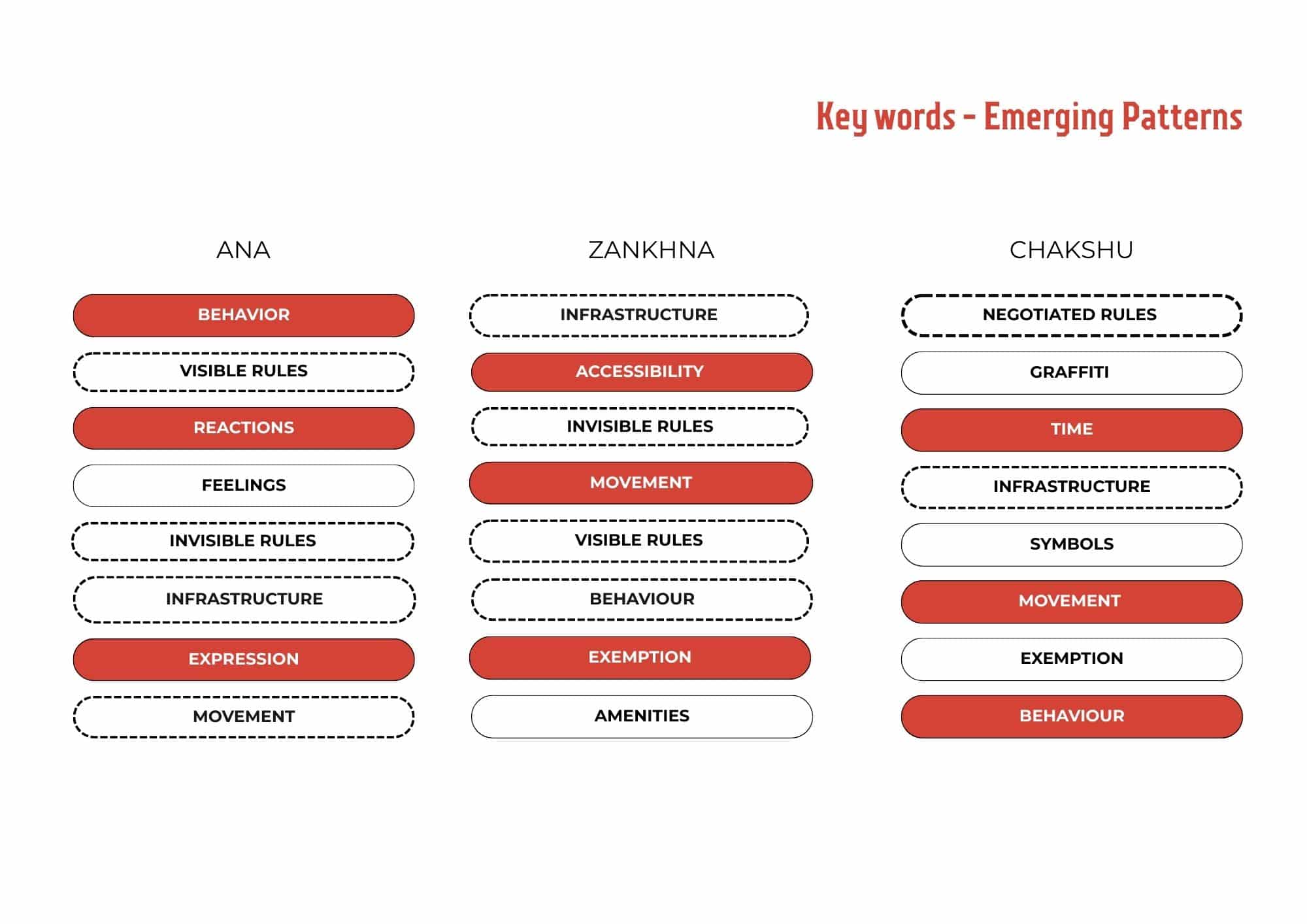
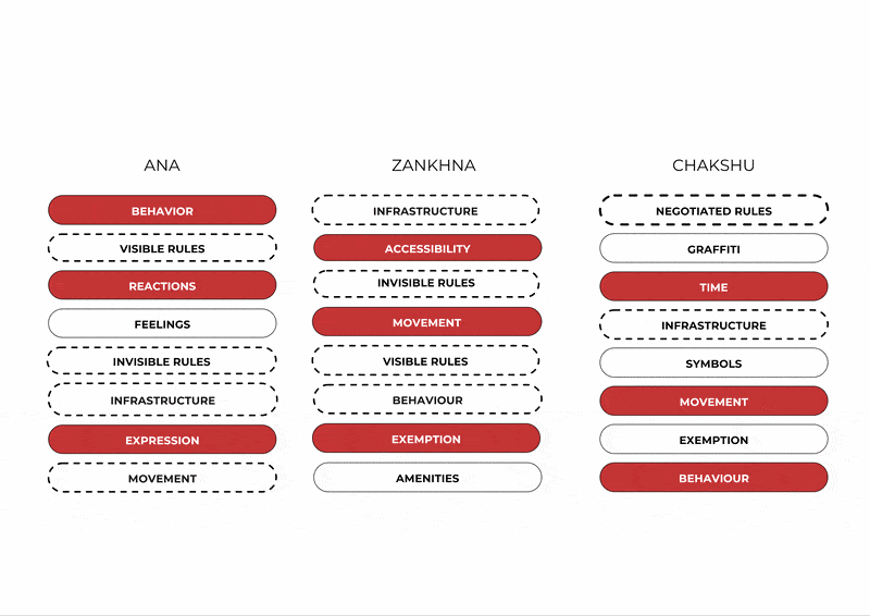
From observations, each walker distilled what they were tracking into keywords. The differences are immediate — but so are the overlaps.
Ana’s words are social and felt: behaviour, reactions, expression. Power as something performed and perceived between bodies.
Zankhna’s words are structural: infrastructure, accessibility, movement. Power encoded in objects and spatial conditions.
Chakshu’s words sit between system and contradiction: negotiated rules, time, symbols. Power observed in the gap between what is permitted and what actually happens.
Three entry points — but movement, infrastructure, invisible rules, and behaviour appear across all three columns. The layers don’t just coexist. They describe the same thing from different angles.
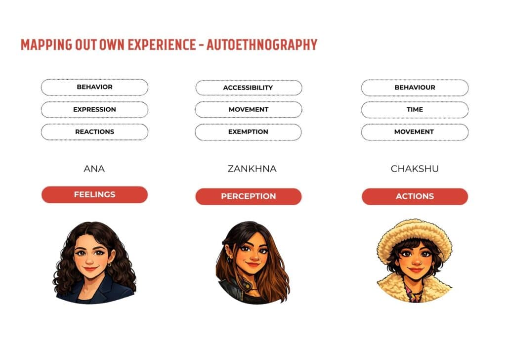
After the field visit, reflecting on our individual observations, one thing became clear — each of us had experienced power differently. Ana was tracking her feelings in relation to space. Zankhna was working through perception and imagined situations. Chakshu was observing actions and objects. Three bodies, same neighbourhood, three distinct entry points into the same question.
These differences became the methodology — each layer built from the perspective its observer actually had, rather than a shared framework imposed from above.
The methodology:
This layer began with feelings — how the body registers power before the mind names it. Moving between the urban street and the beach in Poblenou, the researcher observed how people occupy space: where they sit, how they move, how bodies are positioned. Implicit and explicit expectations were identified, then compared across both environments — asking whether the same behaviours were tolerated, accepted, or judged differently depending on location. Facial reactions and social responses were read as invisible rules made visible through the body.
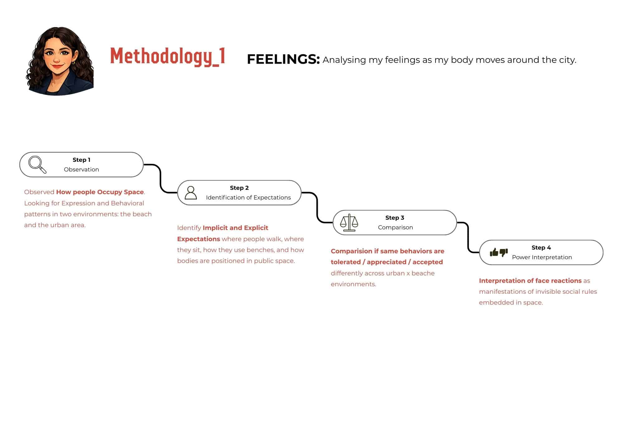
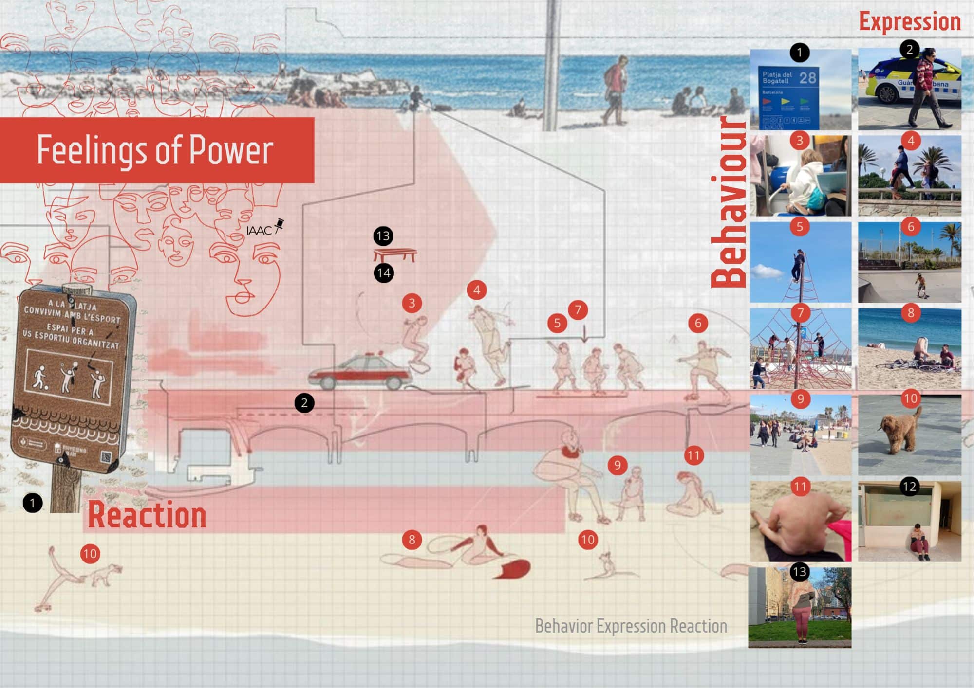
The output:
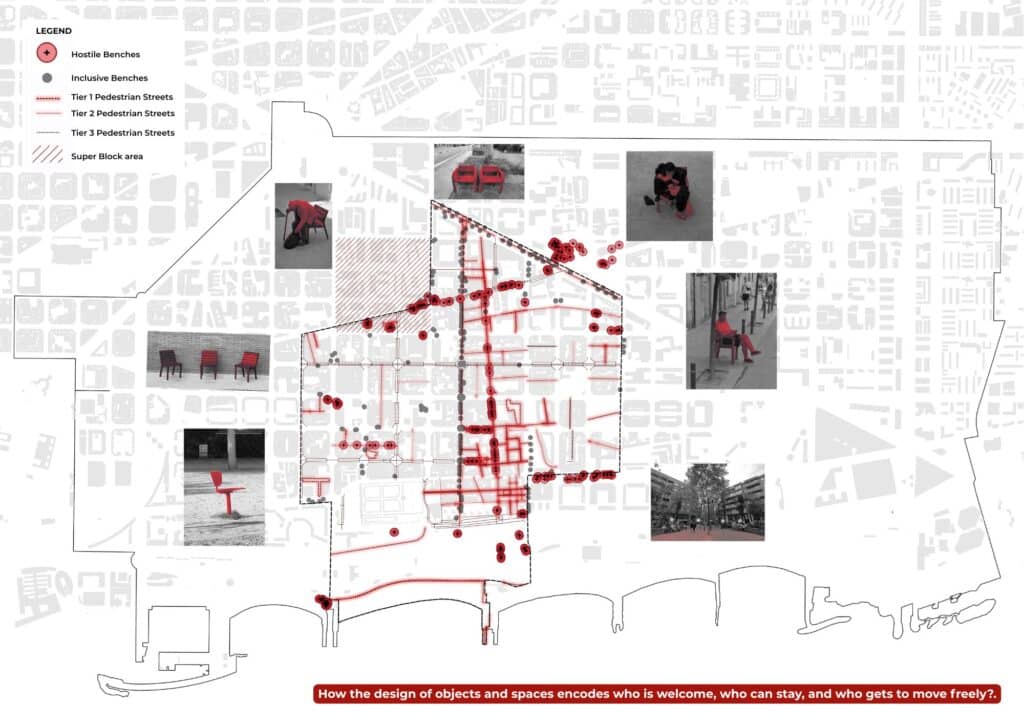
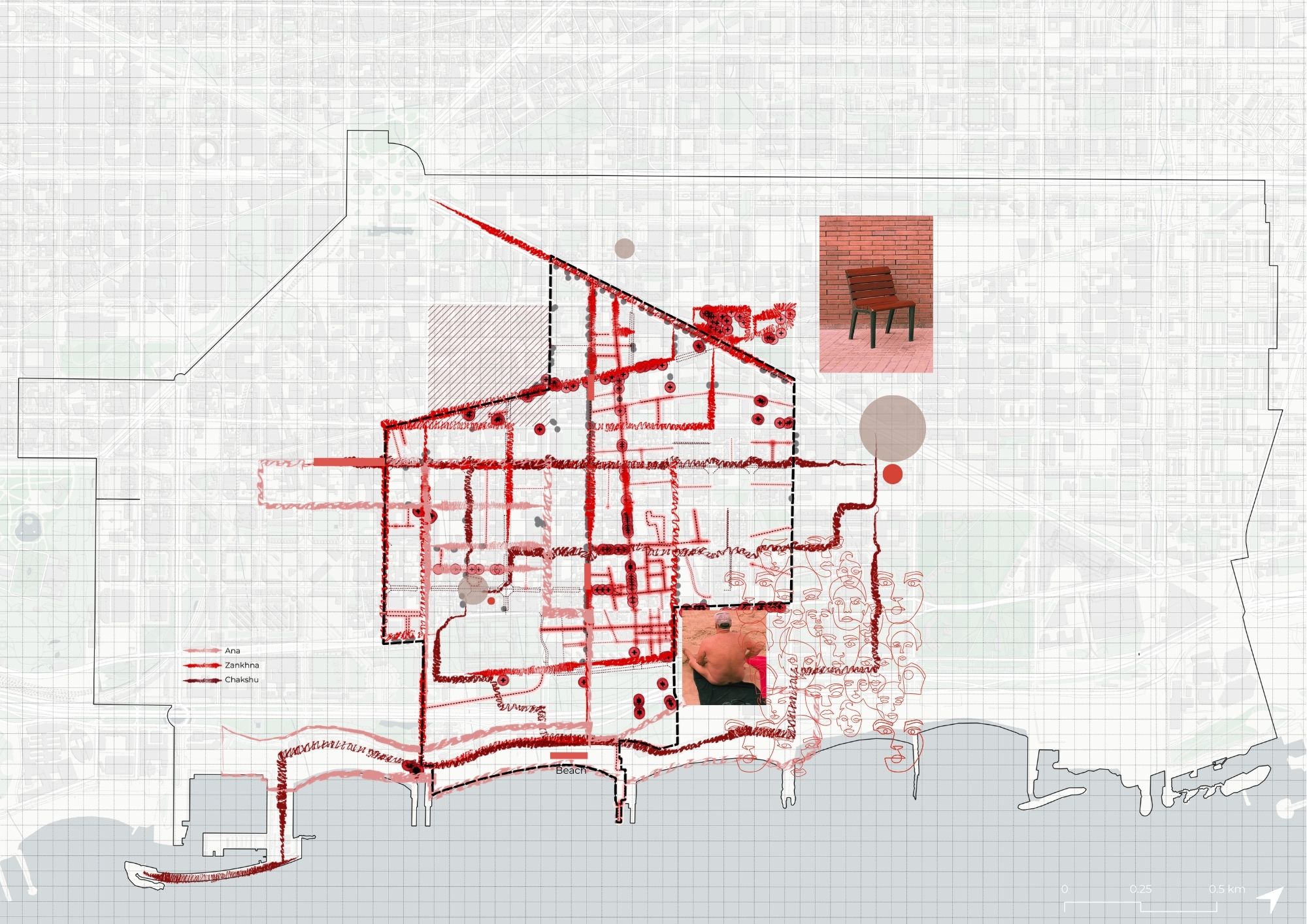
The map places behaviour, expression, and reaction across a section of Poblenou from the urban grid to the beach. Illustrated figures document observed actions — skating, lying down, climbing, nudity, police presence — positioned where they occurred. The red wash marks the transition between regulated urban space and the relative freedom of the beach. The photographs catalogue what was actually seen: a numbered inventory of bodies, each one a data point about what a particular space permits.
The findings:
The beach operates under different rules. Behaviours that attract judgment in the urban street — lying down, physical freedom, partial nudity — are normalised at the beach. The same body, doing the same thing, is read differently depending on which side of the line it stands on. Rules are enforced through reaction not regulation — a glance, a presence, an unspoken threshold. And even the beach is governed: the signage naming what is permitted reveals that freedom here is also conditional, just differently conditioned. Power does not always announce itself. Sometimes it is a glance. Sometimes it is which side of a line your body is on
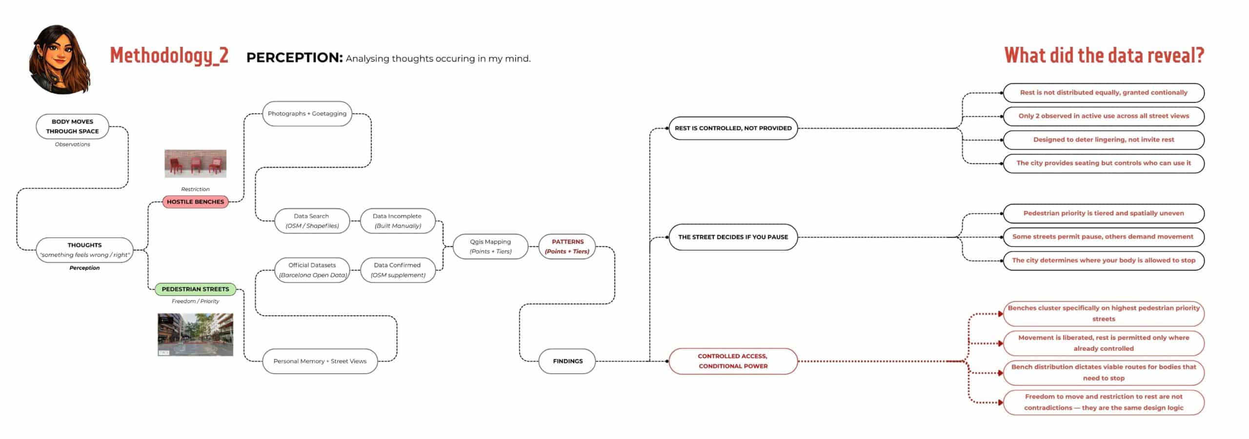
The methodology:
It began with a body moving through Poblenou, Barcelona. The researcher does not drive — a single fact that fundamentally changes how a city is read. Back home in India, not driving meant constantly negotiating with vehicles, always on the edge. In Poblenou, walking felt different. That personal bias became the first analytical lens.
Every street became an observation — noticing where space was designated only for walking, and where pedestrian priority formally outweighed vehicular access. That sense of spatial power, felt before it was analysed, led to mapping the neighbourhood’s pedestrian street hierarchy through existing official datasets and OSM layers, tracing the patterns of who the street was designed for.
The second entry point was a bench. Always on the lookout for somewhere to sit, what kept appearing instead was a bench designed for one person, one direction — impossible to share. That encounter prompted a question: who else couldn’t use this? Someone elderly, someone with a bag, a couple, a group, a person wanting to lie down, someone homeless. The feeling of restriction became a mapping exercise. No dataset existed that distinguished bench typologies at neighbourhood scale, so one was built manually — through photographs, geotagging, and a systematic sweep of the neighbourhood via street view.
Both layers emerged from the same starting point: something felt right or wrong, and the methodology was built to find out why.
The findings:
First — rest is controlled, not provided. Hostile benches dominate the streetscape almost at par with the 2person benches but only 2 of them were observed in active use across all street views which leads me to think that They’re not designed to invite rest. They’re designed to deter it — specifically for the elderly, couples, groups, people with bags, anyone who needs to lie down, anyone who needs to stay longer than intended.
Second — the street decides if you pause. Pedestrian priority in Poblenou is real and tiered, but so uneven. Some streets permit pause, others demand you move through. The city has quietly decided where your body is allowed to stop.
Third — and this is where it gets interesting — benches cluster specifically on the highest pedestrian priority streets. The streets most liberated from vehicles are also the streets most controlled in how bodies can rest. Movement is freed. Rest is permitted only where it is already managed.
The output:
It attempts to make that visible through multiple layers. The varying red lines show three tiers of pedestrian priority — from fully pedestrianized streets to residential streets where space is still negotiated with vehicles. The dots show bench distribution across the neighbourhood: hostile benches marked with a cross, good benches as solid circles. The hatched area marks the 2016 superblock boundary — where the city formally transferred 75% of vehicle surface to pedestrians as part of the 22@ regeneration. “The street was freed from the car. But it was freed for someone specific.”
This pedestrian priority was planned, bounded, and rolled out to attract a specific kind of resident to a formerly industrial neighbourhood. The walking body it imagined was mobile, consuming, passing through. Not sitting too long. Not lying down. Not staying without purpose.
The bench isn’t locked. The street isn’t closed. But something in the pattern of their distribution and design tells certain bodies they are not the intended user. That is what conditional access looks like — not a barrier, not a sign, just a bench that only fits one.
Public space for everyone — but on whose terms?
The methodology:
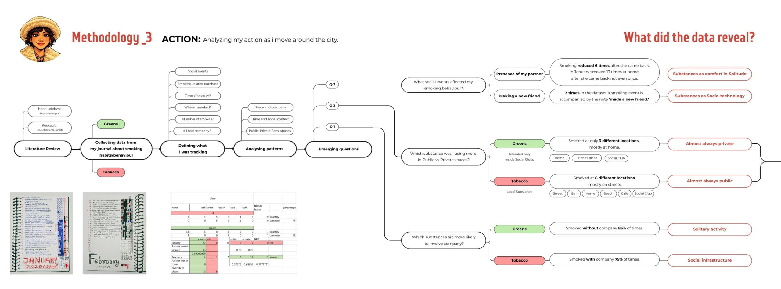
This layer began with the body as instrument — specifically, with action. The researcher tracked her own smoking behaviour across Poblenou over two months, recording where, when, with whom, and what was smoked in a daily journal. From this personal dataset, patterns were identified across six location types: street, bar, home, beach, café, and social club. The methodology then moved from data to questions — what social events affected smoking behaviour? Which substances appeared in which spaces? What does the distribution reveal about power?
The data was analysed through a public-private spectrum, asking not just where smoking occurs but what each space permits, tolerates, or excludes — and why.
The output:
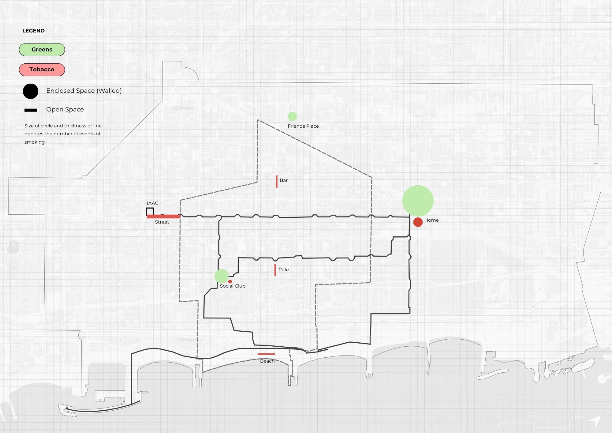
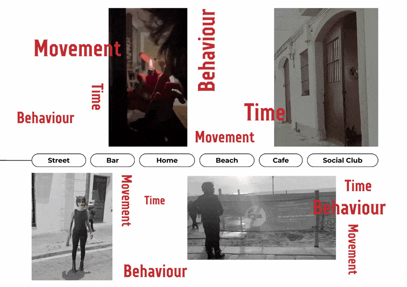
The map plots smoking events across Poblenou by substance and space type. Green dots mark cannabis — enclosed, private, clustered almost entirely at home and the social club. Red marks tobacco — open, mobile, distributed across six different location types. Circle size and line thickness encode frequency. The gif animates the movement between locations, making the daily route and its spatial constraints visible as a lived pattern rather than a static distribution. Movement, Behaviour, Time — names what each space produces in the body: how it changes pace, ritual, and duration depending on where you are and what you’re permitted to do there.
The findings:
First — the partner effect. Smoking reduced significantly when her partner returned. Presence reorganised the meaning of space, what the body needs, and which rituals hold the day together. Intimacy is spatial.
Second — smoke as socio-technology. Tobacco functioned as infrastructure for encounter — a reason to approach, a shared ritual, a temporary community forming in the time it takes to finish a cigarette.
Third — two substances, two spatial regimes. Tobacco is legal, visible, and mobile — appearing across six location types. Cannabis is tolerated only inside designated social clubs — appearing in three, almost always private. The spatial diversity of each substance is a direct map of what power permits.
What this mapping reveals is that smoking is never just a habit — it is a spatial negotiation. Where you can smoke, what you can smoke, and with whom are conditions set by infrastructure, law, and cultural tolerance. The substance doesn’t change. The space around it does — and that difference is entirely political.
Space within itself creates social relations. Repeated social relations produce culture. Culture reinforces how the space is used and felt. It is a loop and power runs through all of it simultaneously.
By linking feelings, perception, and action, the study reframes space as an active agent that produces social relations, where power is embedded in everyday design, norms, and rituals.
