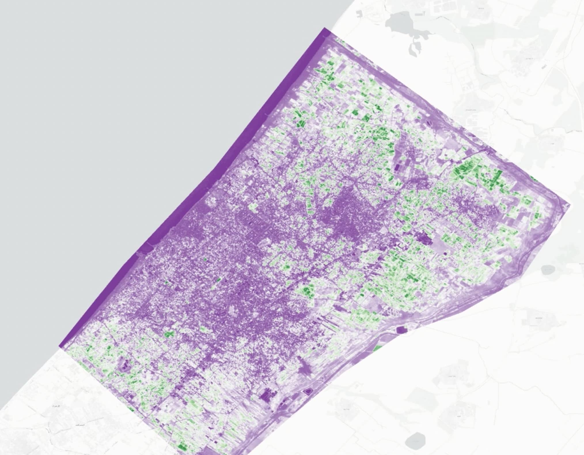
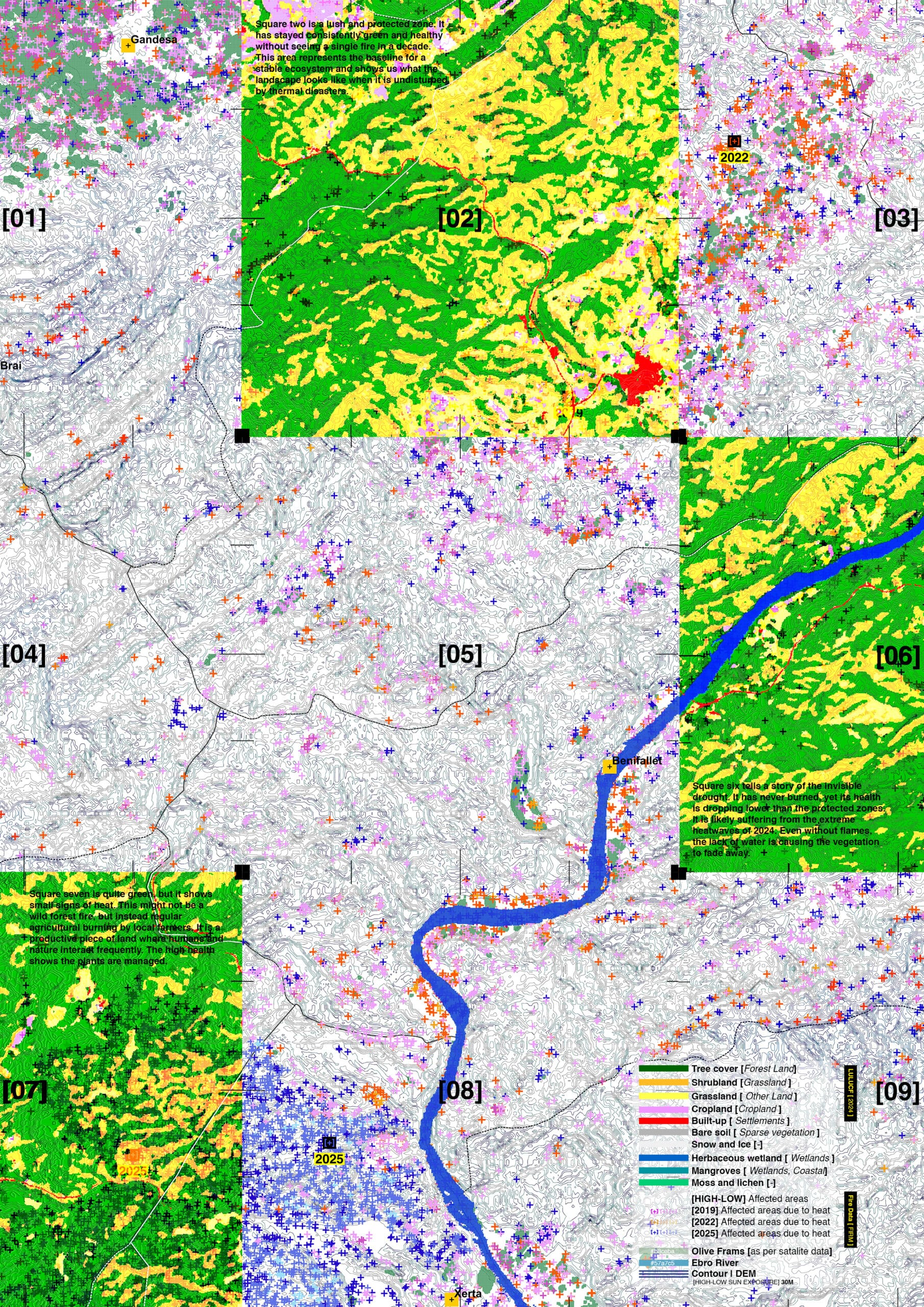
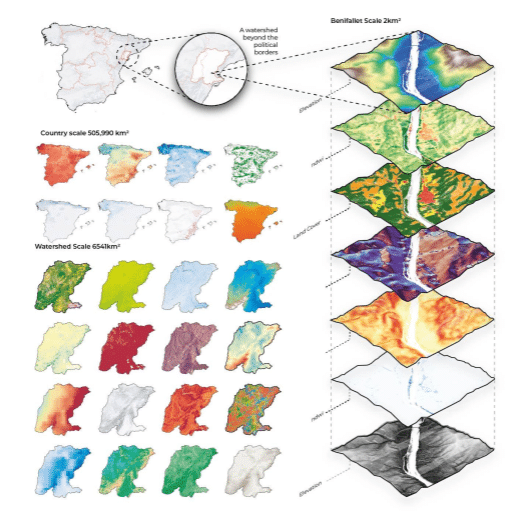
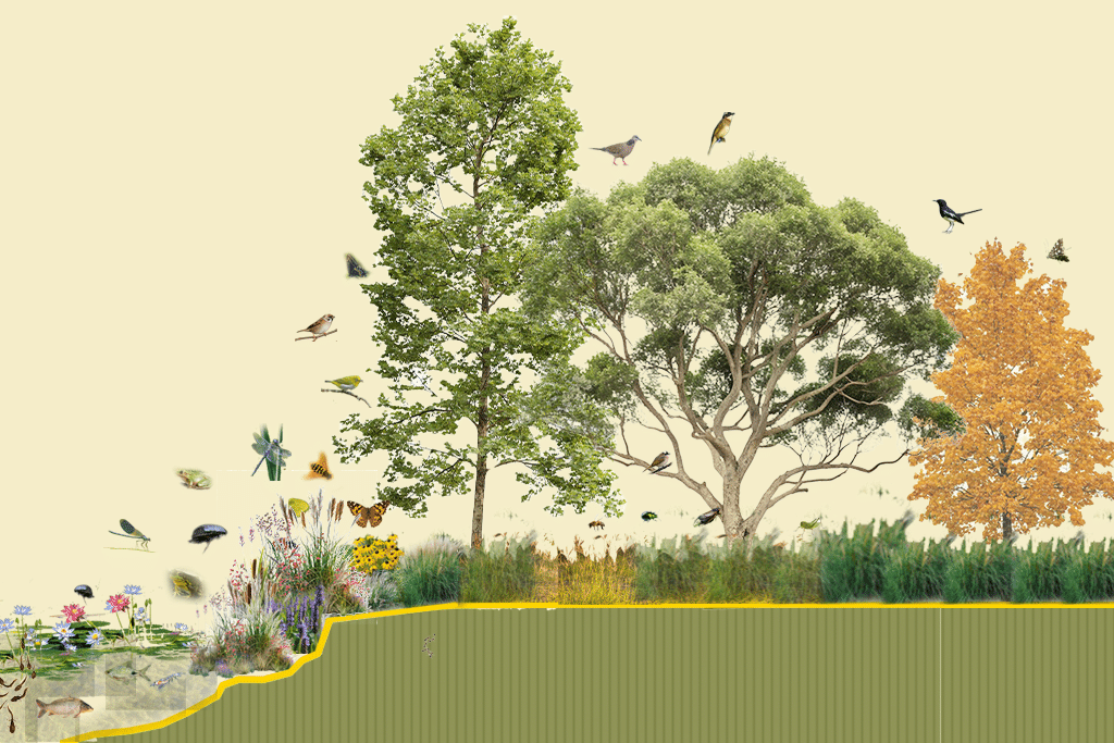
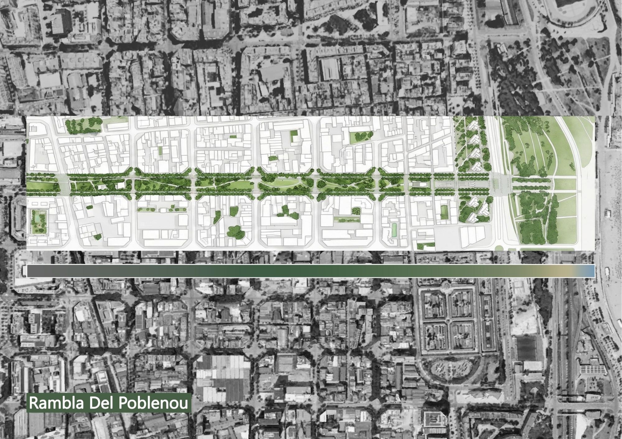
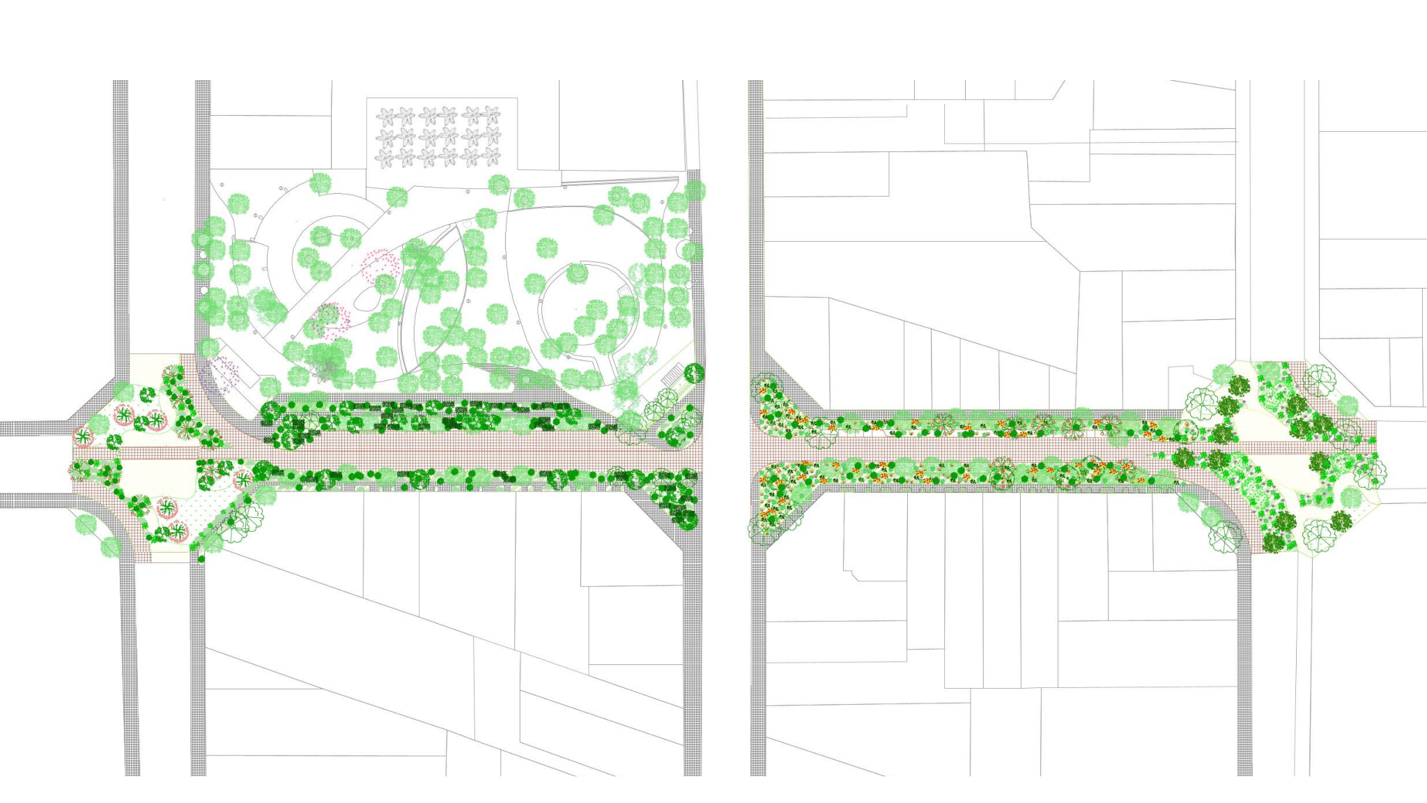
IAAC’s Master in City & Technology (1 or 2-year program) is a unique program oriented towards redefining the analysis, planning, and design of twenty-first-century cities and beyond. The program offers expertise in the design of digitally enhanced, ecological and human-centered urban environments by intersecting the disciplines of urbanism and data science. Taking place in Barcelona, the capital of urbanism, the Master in City & Technology is training the professionals that city administrations, governments, industries, and communities need, to transform the urban environment in the era of big data.


Filters
Course

The Land Remembers

Agricultural landscapes often disappear from visual and political attention during conflict, overshadowed by images of urban destruction. This project uses satellite imagery to examine agricultural land in Gaza, focusing on the Beit Hanoun belt as an intersection between destruction and food systems. Through vegetation indices and bombing crater detection, the study distinguishes seasonal agricultural cycles … Read more

Agent Based Model: A Way to Visualize Alternative Multispecies Futures, Support Decision-making and Empower Collective Action

This proposal envisions an agent-based ecological simulation where human and non-human actors, farmers, water, soil, plants, fungi, and climate, interact within a shared bioregion defined by watersheds rather than political borders. Agricultural technicians serve as mediators between data and local knowledge. Agents are not merely data points but active participants in a living network, continuously … Read more

Fish Tail Park, Nanchang – Case Study

Case Study of Ecological Restoration, Human Presence and Design of Co-Existence Introduction Fish Tail Park is located in the center of Nanchang City, a historic city in southeastern China with approximately 6.6 million residents, has experienced rapid urban growth and high-tech industrial expansion along the Gan River. Is a large-scale ecological restoration project designed by … Read more

Oerliker Park

Oerliker Park in Zürich, Switzerland is not a natural forest that slowly emerged over time. It is a designed urban ecology: structured, calculated, and deliberately designed among buildings and former industrial sites. Even though the park may read as “natural” with its trees, parks like Oerliker are often designed primarily around human use. But parks … Read more

Parc del Centre del Poblenou

This project investigates Parc del Centre del Poblenou through the lens of Designing for More than Humans. The park, although permeable and vegetated, is spatially structured around human circulation and programmed activity. As a result, human occupation is continuous and dominant, while non-human life remains fragmented and residual. Through rule-based speculation, the project tests how … Read more

The Wooded Circle

entrance image Started off in 1504 as a Renaissance-era fortification system, designed to resist cannon warfare. Over the years, it has undergone many reconstructions, with the latest turning it into a managed heritage park in the early 2000s (Planted rows of trees) . Ecology has played an important role in each of its eras, as … Read more

Who else lives here?

Urban space is conventionally conceptualized as an anthropocentric construct. However, non-human species continuously appropriate architectural surfaces, infrastructural voids, and vegetated fragments. Birds occupy ledges and canopy layers, insects colonize engineered soils, bats navigate nocturnal corridors along tree lines, and plants root within pavement fissures. These presences are not incidental; they reflect how spatial design either … Read more

Connexió (Connection)

Santa Coloma de Gramenet, located to the north of Barcelona, is bordered by the Besòs River on the west and the Marina Mountain Range on the north. The city’s terrain features an irregular relief that rises to 303 meters at Mount Castellar, its highest point, a topographical character also visible within Parc dels Pins. The … Read more

in the pursuit of water

Guntur Panchayat, Trichy District Location: 10.7245103, 78.7281189Guntur lake was not maintained for years. After our restoration work the lake is now filled with water.  Peravurani Taluk, Thanjavur district, Tamilnadu Area of the lake: 6 acresWater storage capacity: 40000000 litresLocation: 79.25 ,10.27 athalaikkundu Nochchi Kulam Area of the lake: 55 acresWater storage capacity:80 crore litresLocation10.289601, 79.22789Shrubs and invasive … Read more

Landscape as a Climate Catalyst

Climate Hope, Regenerative Agriculture and Soil Restoration Up to 40% of the world’s land is degraded Poor land management and conventional agricultural practices have degraded soils, reducing their ability to store carbon and absorb water, accelerating climate change and threatening food systems. Soils store 3x more carbon than the atmosphere, but 50-70% of their natural … Read more

Container City

Developed as part of a Workshop hosted by IAAC and conducted by Buro Happold representatives, the project envisions the transformation of Barcelona’s Zona Franca waterfront into a mobility-driven, mixed-use district that balances industry, nature, and urban life. The master plan prioritizes seamless connectivity, enhancing public transport, pedestrian networks, and micromobility infrastructure to overcome the area’s … Read more

Investigating [Soy Farming] – Deforestation, and Political Conflict in the Amazon

“The Amazon rainforest, often called the ‘lungs of the Earth,’ is rapidly disappearing. But this isn’t just an environmental crisis—it’s a geopolitical and economic issue. In the heart of this transformation lies [Mato Grosso], Brazil’s largest soy-producing state. Its key location fuels both economic growth and ecological destruction, leading to tensions over land use, trade … Read more

The Sundarbans: Beyond-Human approach to map cities

The Sundarbans Reserve Forest is the largest contiguous mangrove forest in the world. A wildlife sanctuary with an area of 139,700 ha,  considered as a core breeding area for a number of endangered species (The Sundarbans, n.d.). and home of the Bengal Tiger. STUDY AREA The Sundarbans is a shared protected area between India and … Read more

Flows 4 Santa Coloma

This project envisions a transformative rewilding of the Besòs River in Santa Coloma, integrating human and ecological systems through dynamic, data-driven design. By strategically restoring habitat continuity with green corridors and innovative avian nesting prototypes, it fosters a symbiotic relationship between urban life and nature. Leveraging 3D clay-printed nests inspired by natural forms and utilizing … Read more

FLUTTERING CONNECTIONS

This project is an experiment of connecting Plaça d’Albert Francàs with flora and fauna, giving a prospective of designing for more than humans. This design exercise was built upon the previous workshop “Co-creating Public Spaces”. For more information about the previous proposal, please visit the blog post. In our co-creation project, Spaces of Negotiation, we … Read more