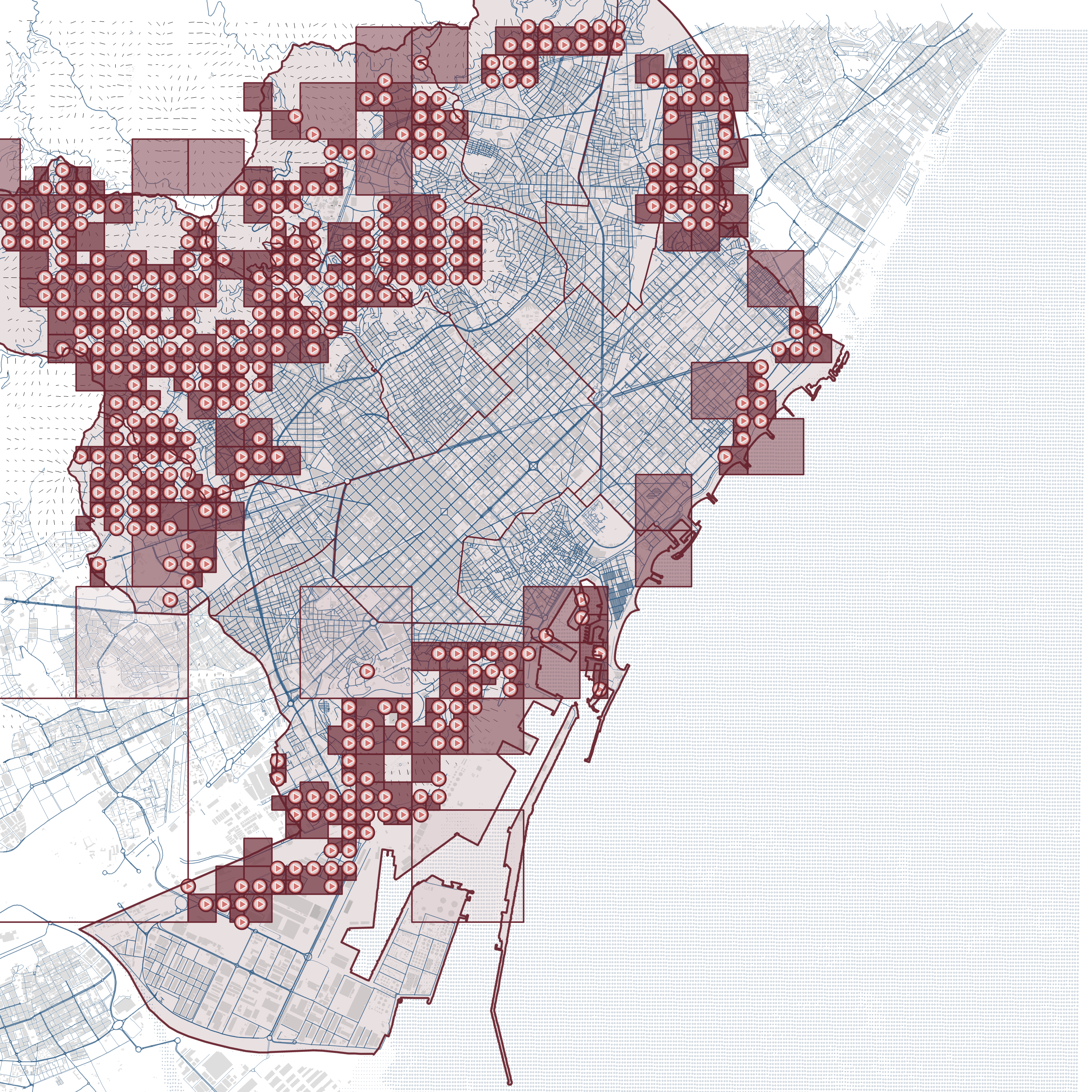
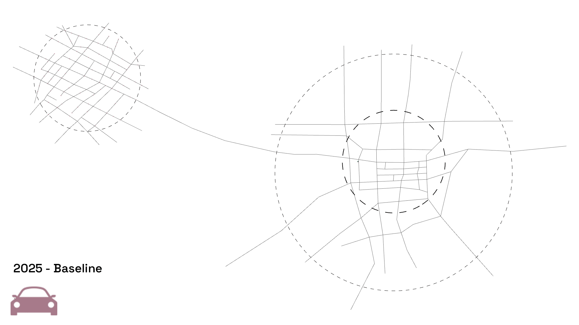
IAAC’s Master in City & Technology (1 or 2-year program) is a unique program oriented towards redefining the analysis, planning, and design of twenty-first-century cities and beyond. The program offers expertise in the design of digitally enhanced, ecological and human-centered urban environments by intersecting the disciplines of urbanism and data science. Taking place in Barcelona, the capital of urbanism, the Master in City & Technology is training the professionals that city administrations, governments, industries, and communities need, to transform the urban environment in the era of big data.


Filters
Course

Cities in Motion

Bogota Public Transport from GTFS

The General Transit Feed Specification (GTFS) is a standardized format designed for the distribution of public transport information globally. This format facilitates the integration of public transportation systems in cities worldwide with popular route planning platforms like Citymapper, Waze, or Moovit. By doing so, it enables users to access information on transport availability and plan … Read more

Routing Accessibility

Background Public transportation plays a crucial role in urban planning globally. Extensive research indicates that bus transit has become a highly favored mass mobility system. This preference stems from its cost-effective infrastructure, flexible planning, and discrete architecture that supports incremental growth. Bus transit systems exhibit lower infrastructure costs compared to rail or subway networks, making … Read more

ONE MUMBAI CITIZEN TOOL

INTRODUCTION Urbanization poses escalating threats to ecological systems, necessitating the creation of urban ecological commons. This exercise focuses on Mumbai’s metro network, comprising 357 kilometres, 16 lines, and 38 interchanges, as a context for enhancing neighbourhood biodiversity through strategic environment plugins. By leveraging NDVI mapping from Google Earth Engine, areas with high ecological threats and … Read more

SKYWARD CONNECTIONS

A Data-driven Approach of redefining the Accessibility of the Dispersed Urbanity of the Aegean Archipelago Accessibility is a multifaceted concept that expresses the case of access between two points in space. In the context of islands, accessibility is of utmost importance due to their inherent characteristics of isolation and small size. The Aegean Archipelago in … Read more

Street sounds of Barcelona

– 00– The project aims to analyze the sounds of streets in Barcelona, cluster them and compare. Firstly, a table of sound types evaluation is created. It consists of point data, network data and sound intensity data. – 01– The methodology and analysis of street segments is based on 1 dataset, that was combined using … Read more

????? • Rent • Proximities

The city of Mumbai, known as the financial and entertainment capital of India, has experienced a significant surge in housing prices and rents in recent years. The demand for residential properties in Mumbai has been steadily increasing due to factors such as population growth, urbanization, and the city’s thriving job market. In the midst of … Read more

Remote sensing of the urban sprawl’s pace of Melbourne

urban growth Melbourne

Starting in 2015 urban development spread beyond the administratively defined Melbourne metropolitan area, into Greater Geelong and the Shire of Mitchell. The Melbourne Metropolitan Region or Greater Melbourne comprises 31 Local Authority Governments (LGA, municipalities and shires) aggregated in 6 metropolitan partnerships. Two of them, Inner and Inner South-East allocate the metropolitan core. This project … Read more

NYC Taxi Time Traveler

The New York City Taxi Trip Duration competition is a challenge to develop a model that predicts the total ride time of taxi trips in New York City. Yellow medallion taxicabs, which number 12,779 in New York City, generate a substantial revenue of $1.8 billion per year by providing transportation services to around 240 million … Read more

Machine learning model to predict NYC cabs’ trip duration

Goal: to predict trip duration of NYC cabs using machine learning models. Tools: Python + Nympy + Pandas + Datetime + Plotly.express + Matplotlib + Math + Seaborn + Bokeh + Sklearn Stages of project: data cleaning, data analysis, data preparation, data testing, evaluating prediction accuracy. Data cleaning The first dataset visualization with splitting datasets … Read more

Data-Driven Rides

Machine Learning-based Analysis of NYC Cab Trip Duration “Data-Driven Rides” is an entry for the first MaCT Machine Learning Competition that hosted on Kaggle which involves predicting the duration of taxi rides in New York City. The dataset provided for this competition is based on the 2016 NYC Yellow Cab trip record dataset and the … Read more

1st Traditional IAAC MaCT ML Competition

#Objective #A Kaggle Competition to MaCT01 students to show their knowledge, designing an end-to-end machine learning project to predict the “Trip Duration” of NYC Taxi trips. #Workflow #First of all a workflow hast do be developed, which represents a classic approach for training machine learning models, analysing the provided training data provided by the submission, … Read more

BullerbyNet

The Core challenges of urban childhood As cities grow and develop, there is often a lack of safe and child-friendly spaces for children to play, walk or bike alone. The increase in traffic and air pollution makes it challenging and unsafe for children to travel on foot or by bicycle. Crime and social fear also … Read more

MOBILITY FOOTPRINT

Introducing the Mobility Footprint, an interactive dashboard designed to promote awareness about mobility in urban environments and its impact on CO2 emissions. By selecting your typical mode of transportation and choosing from eight pre-determined destinations, the dashboard will provide you with a recommended route, estimated travel time, and the CO2 emissions associated with your selected … Read more

Mumbai Dabbawala

Do you nip out to get your lunch from your favourite café, or perhaps use the Uber Eats app to get your lunch delivered to your office? In India, lunch is a whole different ball game. It’s people-powered – made at home that morning and delivered straight to you, all absent of any technology in time. … Read more

Rethinking Industrial Clusters Policies

MOBILITY By selecting the municipalities along the industry belt, we identify the differences about mobility pattern. Commuting people are coming by over half an hour’s trip to work in weekday, but the number of people declines in the weekend.

The Scenic Route

Finding the greenest bicycle path that connects all the parks in Barcelona The shortest walk connecting all the parks was computed based on the road map. The existing bicycle lane does not connect all the parks in Barcelona. Hence, a second shortest path was created by pulling points from the road map to the bicycle … Read more

Urban Data Visualisation – Barcelona and Brazil

The aim of this studio was to explore the design opportunities arising from three common digital fabrication processes: Laser Cutting, CNC milling and 3D Printing. These exercises were supported by an interactive exploration of each technology and material, while also understanding conceptual and prototyping process of design. 1. Laser Cutting The first digital fabrication exercise … Read more

Streets for People: La Barceloneta

La Barceloneta is one of the most popular neighborhoods in Barcelona. This old fishermen’s neighborhood forms an inseparable entity with the beach of the same name and is synonymous with a lot of charm, food gastronomy, old traditional pubs and a very lively atmosphere. The aim of the proposal is to identify the streets that … Read more

Pedestrianize La Sagrada Familia neighborhood

What is La Sagrada Familia neigborhood? First of all, La Sagrada Familia cathedral is one of the most visited by tourists attractions in Spain. History of La Sagrada Familia Quartier. Urban design issue Initially, Antonio Gaudi, while in charge of designing La Sagrada, envisioned removing two inhabited blocks in front of the main facade of … Read more