
IAAC’s Master in City & Technology (1 or 2-year program) is a unique program oriented towards redefining the analysis, planning, and design of twenty-first-century cities and beyond. The program offers expertise in the design of digitally enhanced, ecological and human-centered urban environments by intersecting the disciplines of urbanism and data science. Taking place in Barcelona, the capital of urbanism, the Master in City & Technology is training the professionals that city administrations, governments, industries, and communities need, to transform the urban environment in the era of big data.

Flows and Barriers
Understanding the way pedestrians move through space is a task of heavy importance in the design and analysis of public space. It is fundamental to understand the motivations and utilities that influence the way pedestrians move through space. In cities such as Bogota, Colombia, heavy car-centered infrastructure has fragmented the city into clusters that limit … Read more
Hyperenergetic Viladecans
By 2100, the global temperature is forecasted to increase from 2 to 4 degrees Celsius due the effects of Greenhouse Gases Emissions and Human Activities. The City of Viladecans has developed a Vision by 2030 which expects the city to become EMISSIONS NEUTRAL, and EMISSIONS NEGATIVE by 2050. For approaching this goal, HYPENERGETIC VILADECANS establishes … Read more
City in Motion: Analyzing People Movement with Agent-Based Modeling

In the realm of urban design, understanding movement behaviors is paramount for creating efficient and people-centric city layouts. In this individual project, I delve into the intricacies of movement behaviors using computational tools and techniques, including agent-based modeling. By incorporating the loop evaluate field amplitude tool and employing vector display, scalar fields, heat maps, and … Read more
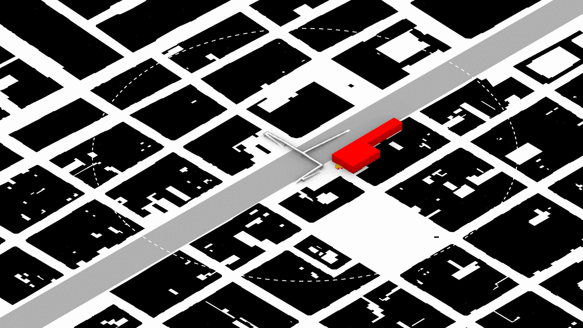
Gates in the Street

Looking for a correlation between the presence of closed condominiums in Bogota and Crime Rate “In Bogotá, one third of households live in gated communities. This phenomenon is a misleading application of the model idealized by the post-war urbanized American suburbs where an ideal, safe, happy, perfect life was idealized. A life where mobility prioritizes … Read more
Unequal Blooms: Studying socioeconomic realities of Medellín’s “Eternal Spring”
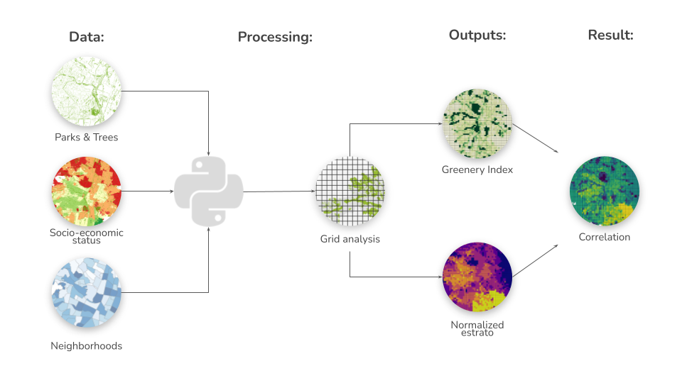
Introduction In recent decades, the importance of urban green spaces and their potential impact on various aspects of urban life has gained significant attention from policymakers, urban planners, and researchers worldwide. The creation and maintenance of green spaces within urban environments have been associated with numerous benefits, including environmental sustainability, physical and mental health improvements, … Read more
45 Years of Piracy: Strengthening Global Maritime Security through Non-Military Approaches

Our project embarked on a mission to tackle global shipping piracy without resorting to military action. We faced a major challenge: finding and using publicly available information to craft a proposal that countries and international organizations would support. 1. WHY SHIPPING PIRACY? Within the context of Networked Flows, our directive was to pinpoint potential disruptions … Read more
Protected: What is Advanced Air Mobility? [VOL. II]

There is no excerpt because this is a protected post.
Art on air
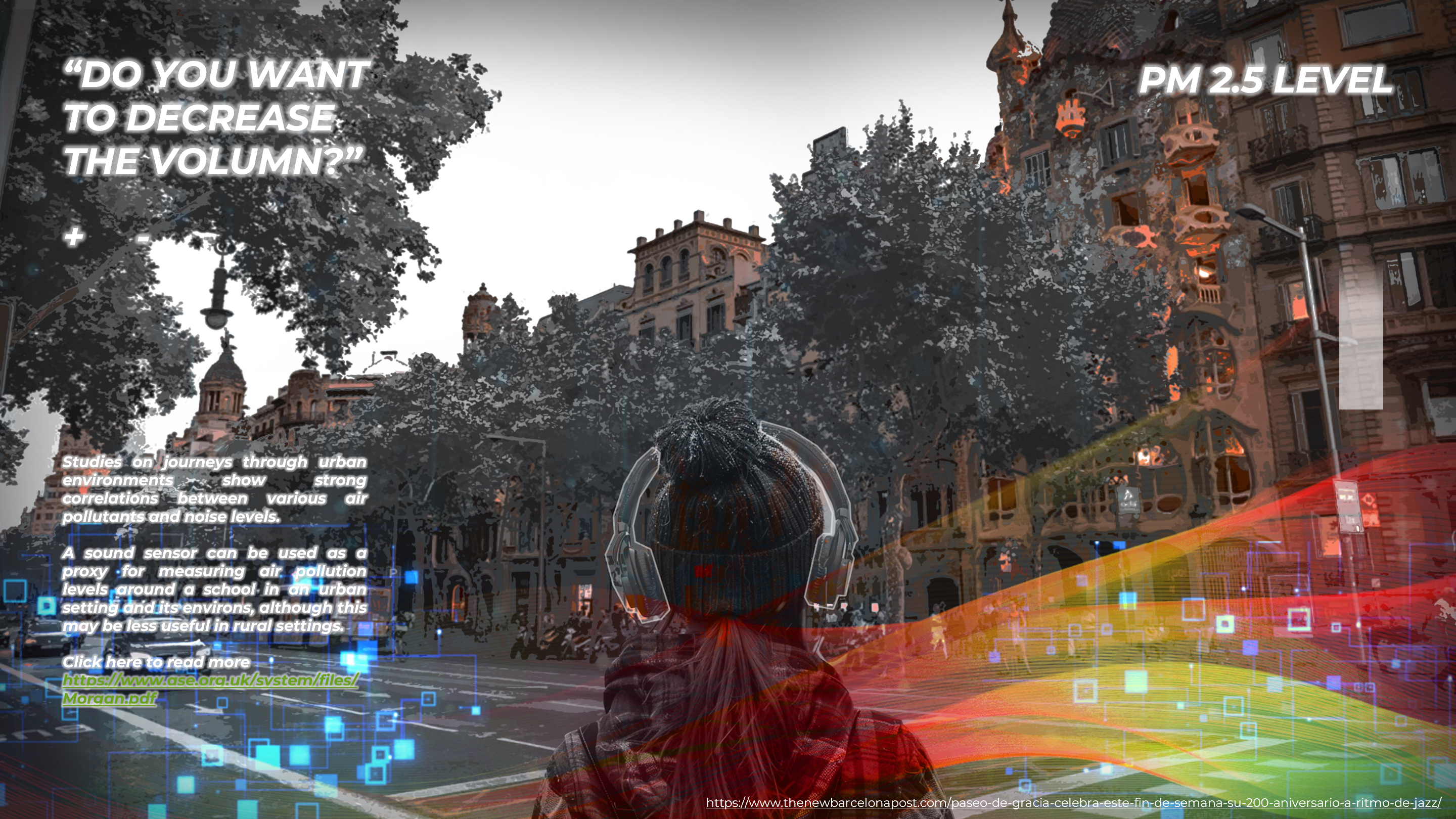
Introduction Air quality is a problem in many cities around the world, yet it remains largely invisible to the naked eye. This reality struck us deeply when the four of us, having lived in Barcelona, Lagos, Bangkok, and Medellin – our four cities of origin – came together. Amidst our diverse backgrounds and experiences, we … Read more
Protected: What is Advanced Air Mobility? [VOL. I]
There is no excerpt because this is a protected post.
Decoding Urban Degrowth I

Green Democracy Green Democracy is an interdisciplinary initiative advancing environmental justice, urban wellbeing, and evidence-based sustainable development. https://www.linkedin.com/company/greendemocracy/?viewAsMember=true
Tourism and social development, Balearic Island

INTRODUCTION The heavy working hours after the industrial revolution had put leisure to a more and more important role in contemporary life. People want to travel to ‘escape’ and compensate themselves from work and daily life. The practice of leveraging tourism for economy growth has been proved useful in Spain since the 1960s. And this … Read more
Protected: Housing For All – Building Inequalities?
There is no excerpt because this is a protected post.
Coltura

Introduction Milan, Northern Italy’s epicenter, confronts economic and environmental challenges rooted in a shift from agriculture to manufacturing. To secure its future, Milan invests in knowledge, tourism, and place-based innovation, relying on revenue from high-income foreigners, students, and the European Union. Strategic efforts to transition to a green economy focus on renewable energy, waste reduction, … Read more
From Pollution To Pollination
1. Introduction Urban air quality is a pressing concern, being the result of both natural elements and human-induced pollutants. The city of Barcelona grapples with local pollutants like NOx and PM10, primarily caused by ground transport and industrial activities. While current policies focus on mobility solutions, the project questions the need for complementary approaches. The … Read more
