A Data-driven Approach of redefining the Accessibility of the Dispersed Urbanity of the Aegean Archipelago
Accessibility is a multifaceted concept that expresses the case of access between two points in space. In the context of islands, accessibility is of utmost importance due to their inherent characteristics of isolation and small size. The Aegean Archipelago in Greece is characterized by fragmented spaces, making the islands, particularly the smaller ones, the least accessible areas within the country. While the Aegean islands are highly sought-after tourist destinations, attracting a significant influx of visitors during the tourist season, residents of these islands, especially those in smaller communities, face challenges when it comes to accessibility. This aspect of accessibility encompasses more than just the availability of transportation connections; it also includes access to necessary services that cater to the needs of the islanders and the time required to reach these services, which may be located in different destinations. Accessibility has both a ‘real’ and ‘psychological’ or perceived dimension. The first is related to infrastructure or services (available transportation modes and the quality of each craft/vessel), the frequency of connections, the destination (the mainland, or another island) in relation to the reason for travel, and of course cost. The later dimension is related to how people perceive and evaluate accessibility. In this study, geographical distance ,accessibility potential and availability of services in the Aegean Archipelago are analyzed, combining different transportation modal choices. The Greek policies for the accessibility of islands has focused in the past decades on a largely concentric radial transport system, around Piraeus port and Athens International Airport “Eleftherios Venizelos” which is an expression of the “Athenian centricity” of the transport system. This results in the existence of regional centers of reduced power and the lack and impracticability of creating strong focal transportation and administrative centers.
HYPOTHESIS
“The geographical distance is not determining the “real” accessibility of the islands. The radial “Athenian centric” transportation system does not serve smaller islands and that more local everyday or frequent links between smaller and more inaccessible islands and nearby bigger ones, can be the key towards a cheaper and more efficient transportation system.”
METHODOLOGY
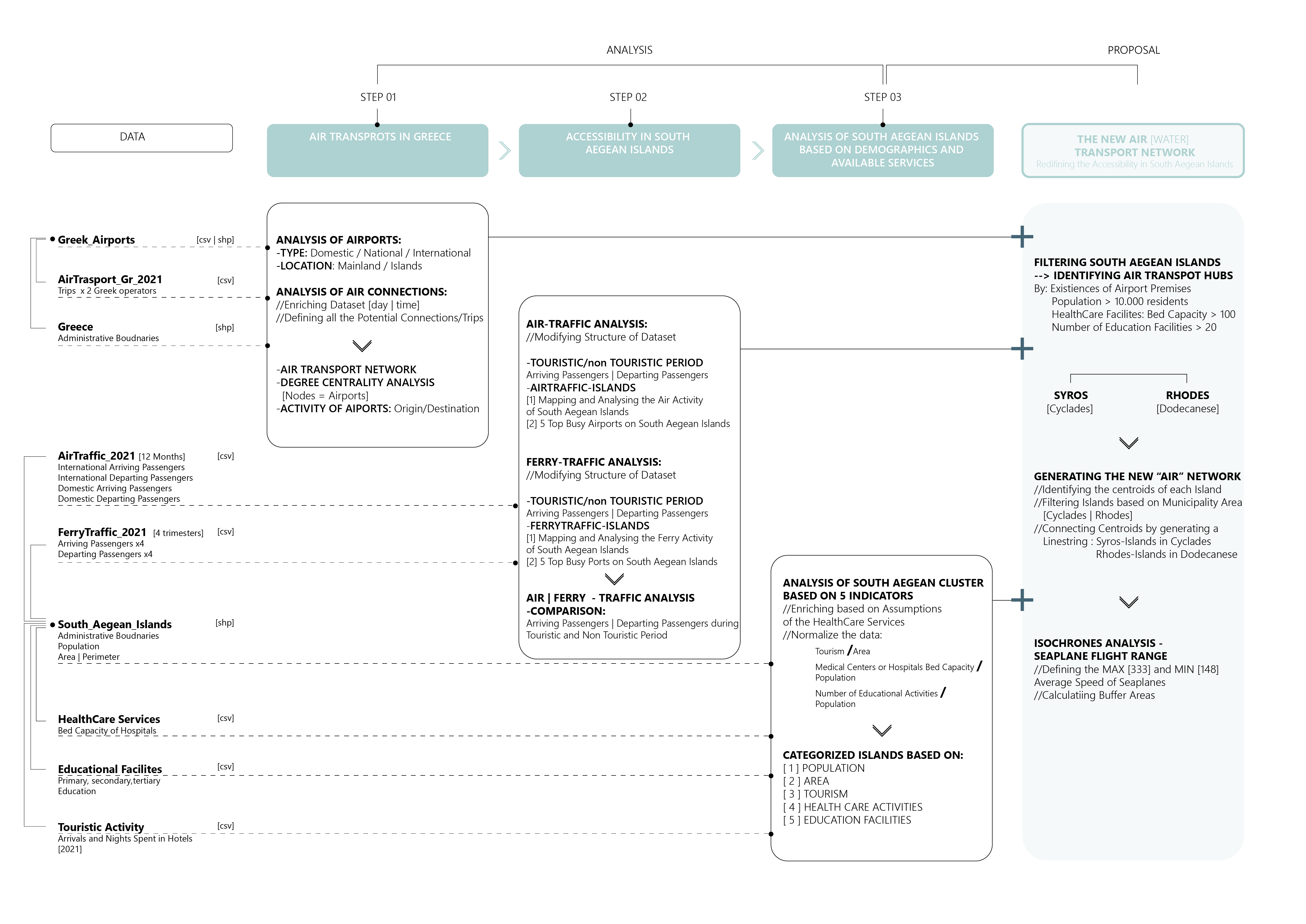
STEP01: AIRTRANSPORTS IN GREECE
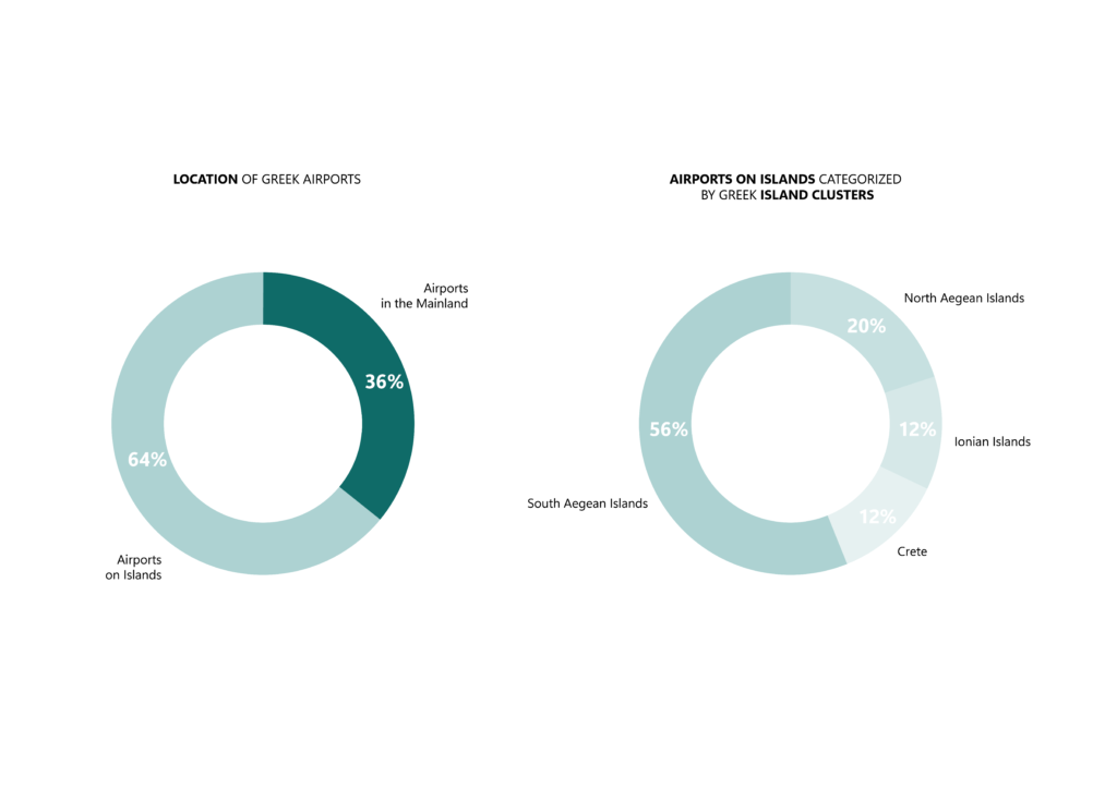
Greece, despite its small territorial size, boasts the highest number of international airports compared to any other European country. The air transport industry in Greece is served by an extensive network of 39 airports, which can be classified into three categories: domestic (4), national (20), and international (15). While 11 of these airports are situated on the mainland, the majority are located on various islands. A significant proportion of these island airports can be found in the South Aegean Islands, which serve as analysis area of the study.
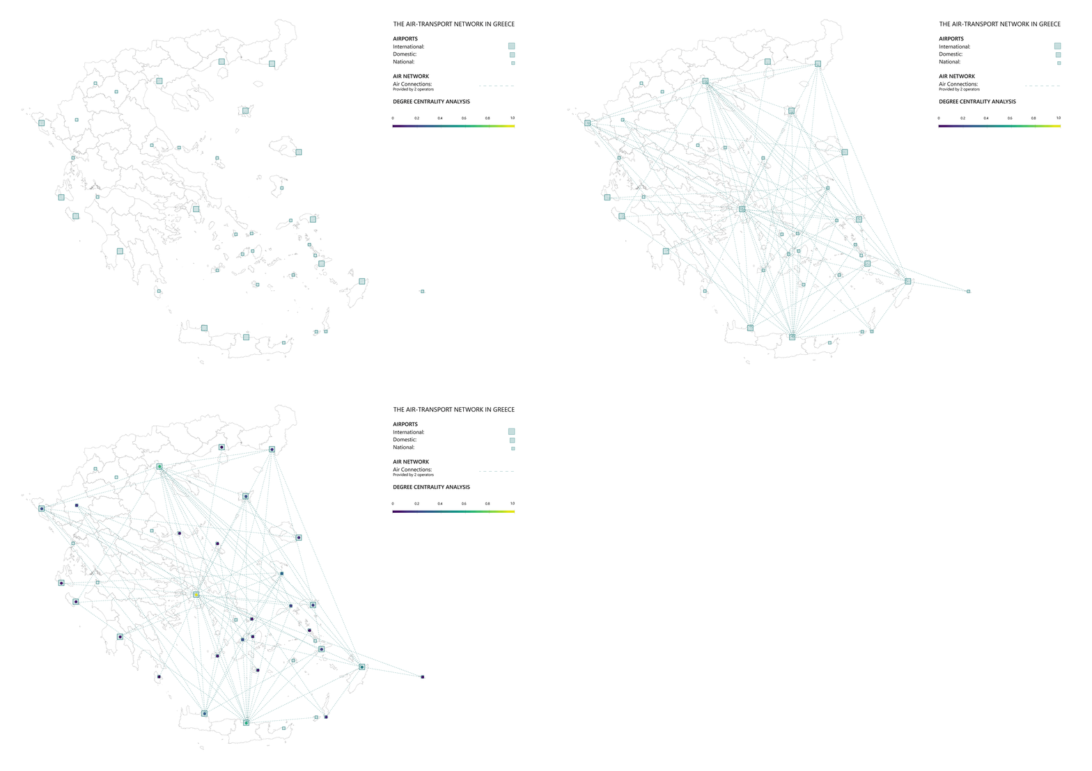
The analysis of Degree Centrality clearly highlights Athens as the primary focal point of Greece’s air transportation system, with “Athens International Airport “Eleftherios Venizelos” serving as the central hub. However, other significant centers of air activity include “Thessaloniki Macedonia International Airport, “Heraklion International Nikos Kazantzakis Airport, and “Diagoras Airport” located in the South Aegean Islands. Rather than serving as central nodes for connectivity within the domestic air transport system, the remaining airports in the South Aegean Islands primarily fulfill the role of accommodating the increased levels of international arriving and departing traffic, particularly during the tourist season.

A similar pattern emerges when analyzing the number of weekly trips per route revealing a correlation between the origin and destination airports in terms of trip volumes. Notably, certain airports in the South Aegean Islands experience a higher volume of weekly trips , including Rhodes, Kos, Paros, Milos, Naxos, Mykonos, and Santorini airports (listed in descending order).
STEP02: ACCESSIBILITY IN SOUTH AEGEAN ISLANDS
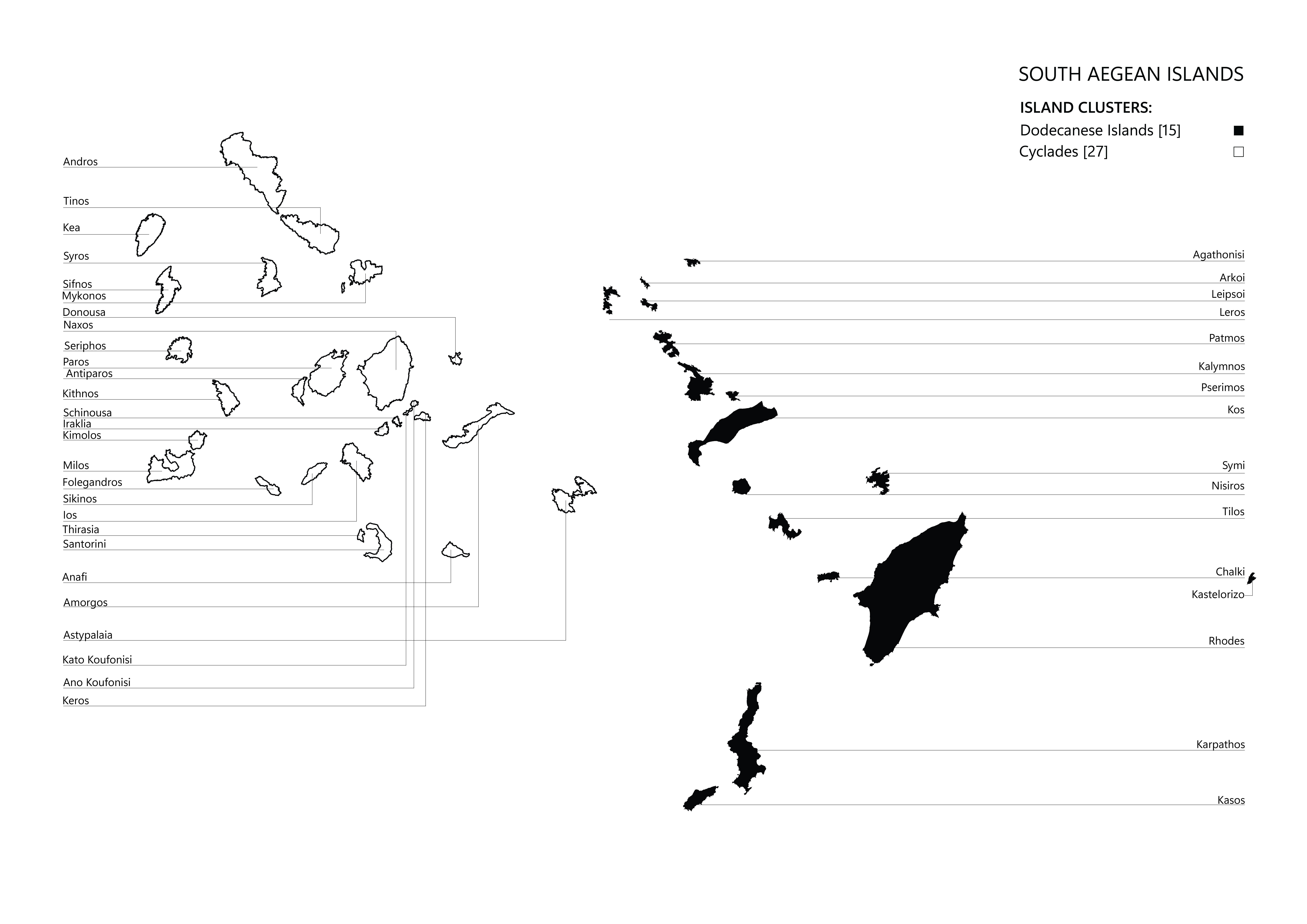
The case study area of the project, the South Aegean Archipelago consists of two island clusters, known as the Cyclades and the Dodecanese, encompassing a total of 42 islands along with numerous smaller islets. Every island possesses a minimum of one primary port, while 14 islands are equipped with airport facilities, contributing to a diverse range of accessibility and connectivity options.
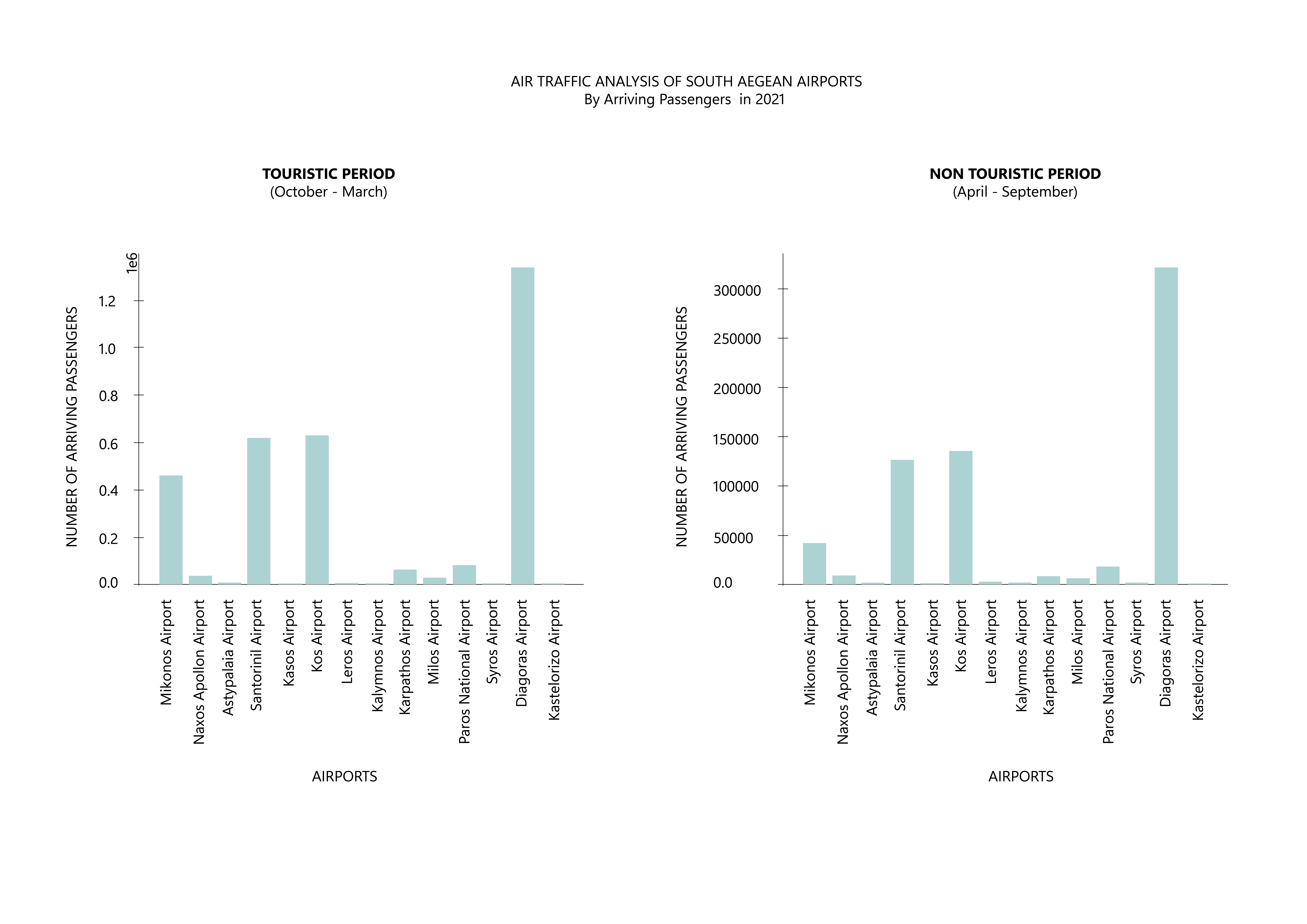
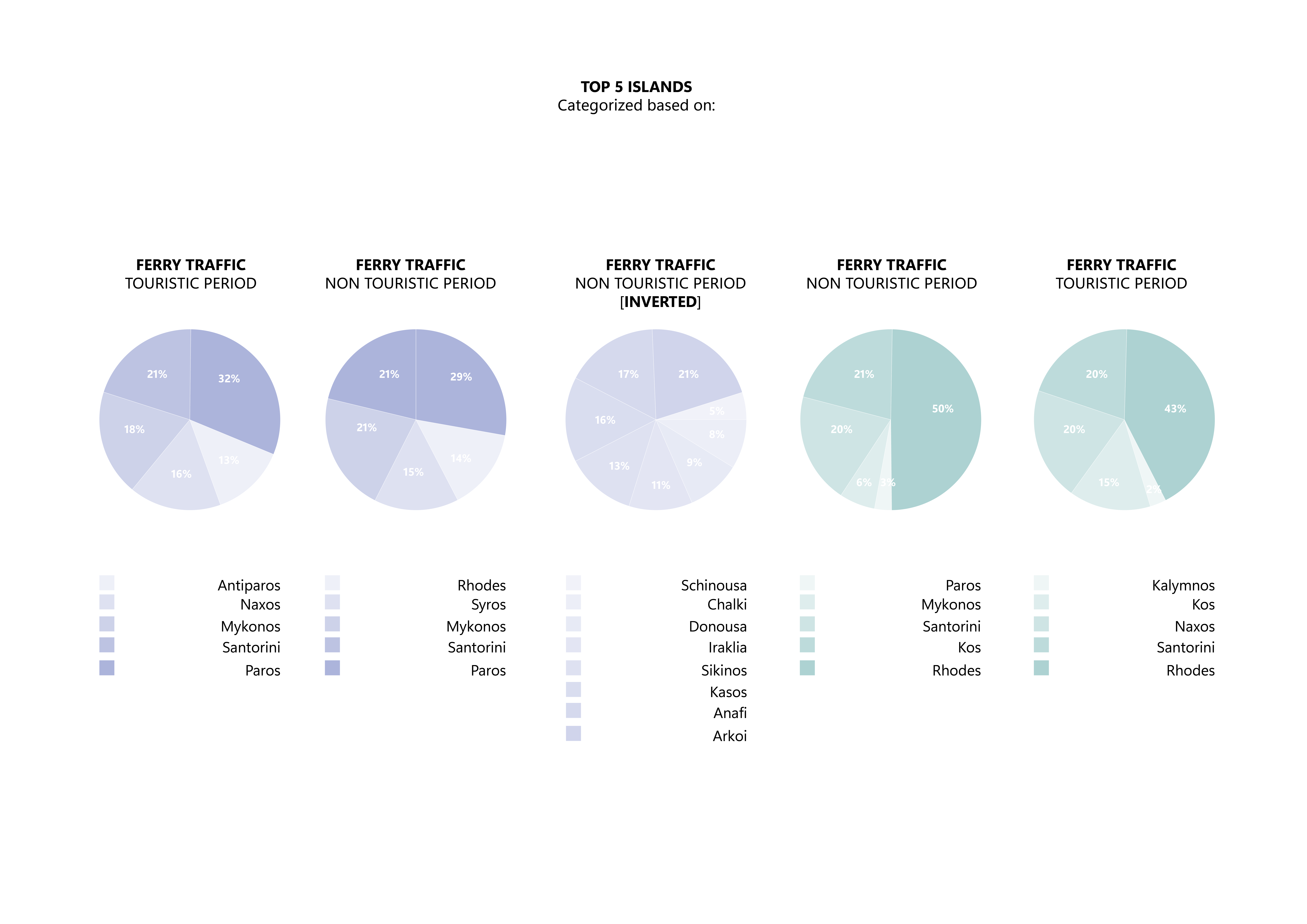
Upon analyzing the air traffic data for the year 2021, a notable and consistent trend emerges for both the tourist and non-tourist periods, particularly regarding the volume of arriving passengers. In this regard, the islands of Rhodes, Kos, Santorini and Mykonos stand out as the destinations with the highest air passenger traffic throughout the year due to their thriving tourist activity. Interestingly, when examining ferry traffic data, it was observed that ports in medium-sized islands, such as Naxos, played a crucial role in facilitating ferry transportation, particularly to smaller islands. These ports, along with significant islands based on the available services like Syros, served as important “water” hubs despite having relatively low air traffic. These trends were particularly noticeable in the Cyclades cluster, where the ferry network played a crucial role due to its proximity to Athens in terms of geographical distance and travel time. In contrast, the Dodecanese Islands, which are farther from Athens, relied more heavily on air connections to connect the region.


During the non-touristic period, the ports located on very small islands, which are known for their limited size, population, and available services, experience the least amount of activity. These islands are often the most isolated among all the destinations. However, based on he spatial analysis, the presence of islands with significant passenger ferry traffic in close proximity to these extremely small islands underscores the importance of an efficient air-ferry transportation network that can efficiently cater to short and multiple connections/routes
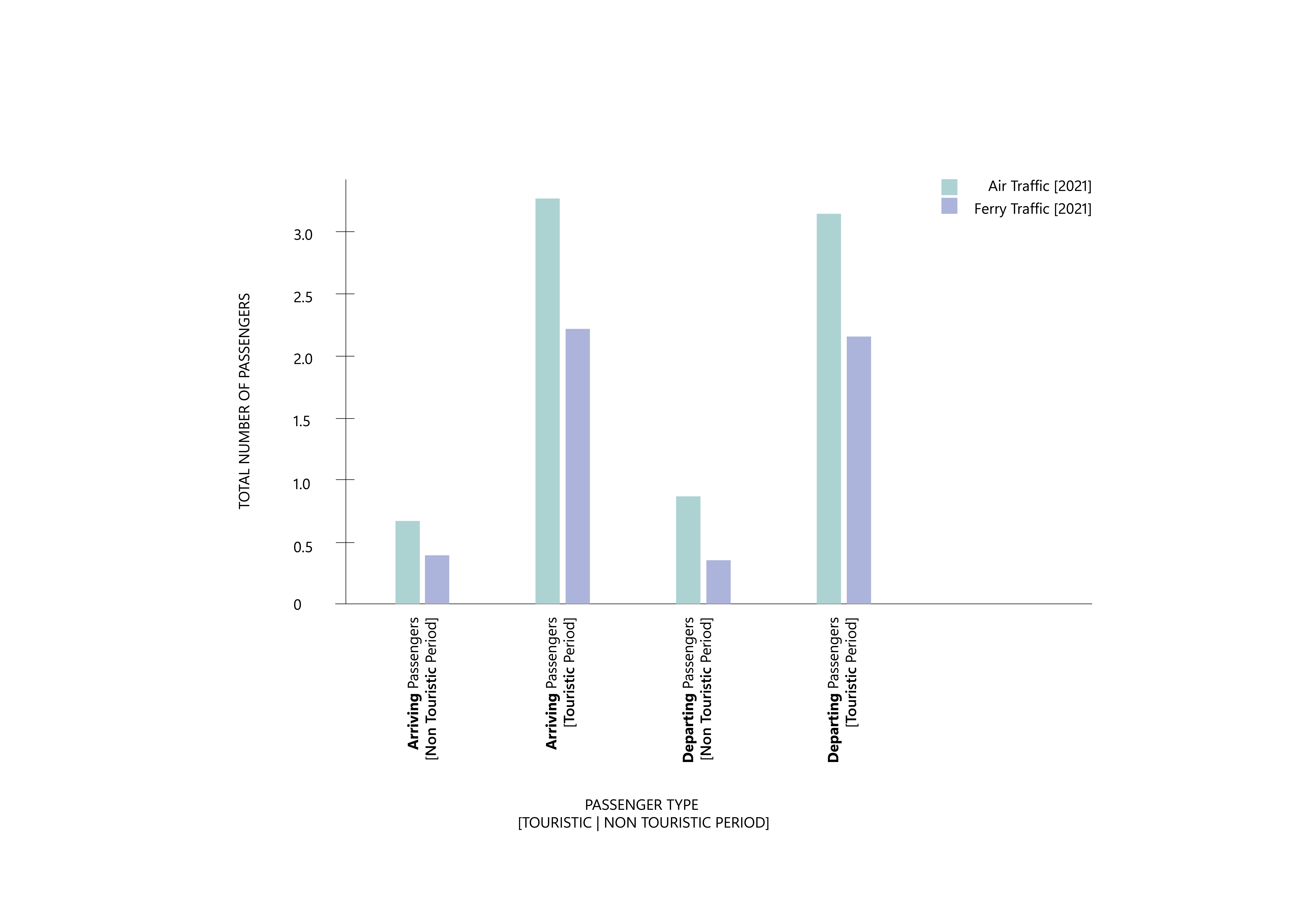
When comparing passenger air traffic and ferry traffic in 2021, it becomes apparent that during the tourist season, the number of arriving or departing passengers is five times higher for both modes of transportation compared to the non-touristic period. Despite air traffic slightly surpassing ferry traffic throughout the year, this can be largely attributed to factors such as time efficiency, cost considerations, and weather conditions. Nevertheless, there is a noticeable absence of efficient coordination between the air and ferry transportation systems, leading to inadequate service coverage for the entire South Aegean Region, especially for the islanders of the exceptionally small islands
PART03: ANALYSIS OF SOUTH AEGEAN ISLANDS BASED ON DEMOGRAPHICS AND AVAILABLE SERVICES
By conducting an analysis of the South Aegean Islands that takes into account demographics and available services on each island, a deeper understanding of the island cluster’s functioning and the daily lives of its residents can be obtained. Furthermore, such an analysis helps identify potential air transport hubs that not only cater to tourist air traffic but also support the needs of permanent citizens.
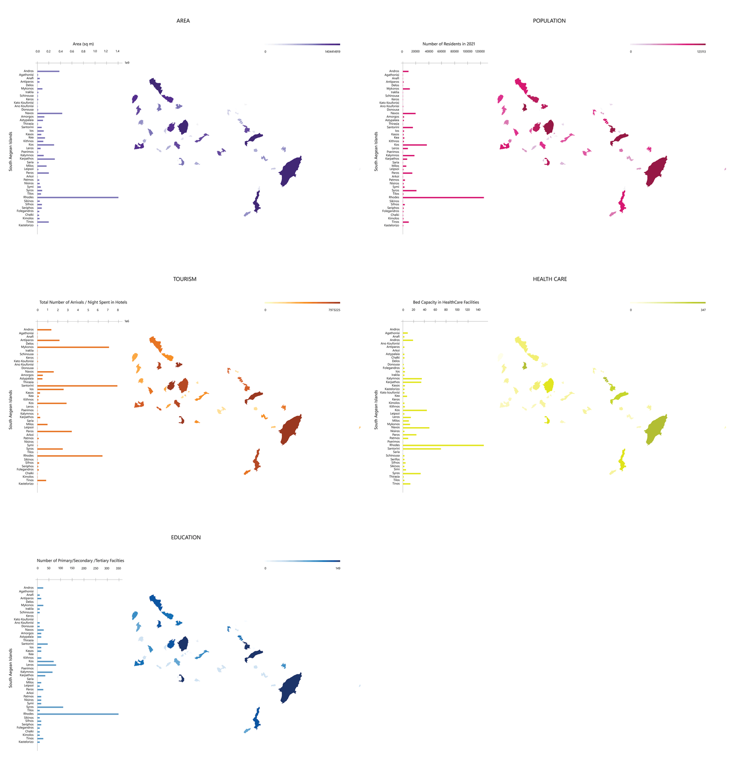
In general, the islands in the Dodecanese cluster demonstrate a greater level of self-reliance in comparison to those in the Cyclades.
- Rhodes Island, the capital of the Dodecanese Islands, stands out as a potential hub due to its excellent connectivity and significant air traffic activity. It offers a wide range of services, not only meeting its own needs but also catering to the neighboring islands.
- On the other hand, popular tourist destinations like Mykonos and Santorini in the Cyclades face challenges in meeting the demands of both tourists and local residents due to a lack of sufficient available services. Despite lower air traffic activity, islands such as Syros and Naxos possess the potential to serve as air transport hubs due to their proximity to more “vulnerable” islands and the presence of essential services.

STEP04: REDIFINING THE ACCESSIBILITY IN SOUTH AEGEAN ISLANDS-THE NEW AIR/WATER TRANSPORT NETWORK
The current transportation system in the South Aegean Archipelago seems to lack efficiency in terms of connectivity, available facilities, and modes of transport, particularly for the smaller islands. Given the geographical proximity and moderate size of the islands, relying solely on airplanes for transportation may not be the most suitable option, as airports primarily cater to the needs of the tourism industry. On the other hand, the ferry network operates relatively well but faces limitations due to unpredictable weather conditions and significant distances between the islands and the mainland, leading to time constraints. To address these challenges, the introduction of seaplanes presents an ideal solution to enhance the synergy between the air and ferry transport systems. Seaplanes are highly efficient for short distances and multiple connections, and utilizing existing airport and port infrastructure would enhance accessibility and connectivity between each island and the main air or ferry transport hubs within the cluster. By establishing diverse transportation links, seaplanes can effectively connect various parts of the region and provide a unique means of connecting the South Aegean Islands with the mainland. This diverse range of connections and transportation options has the potential to significantly enhance accessibility for islanders, both thr real and psychological dimension.
The design of the new air transport network relies on three primary steps/parameters.
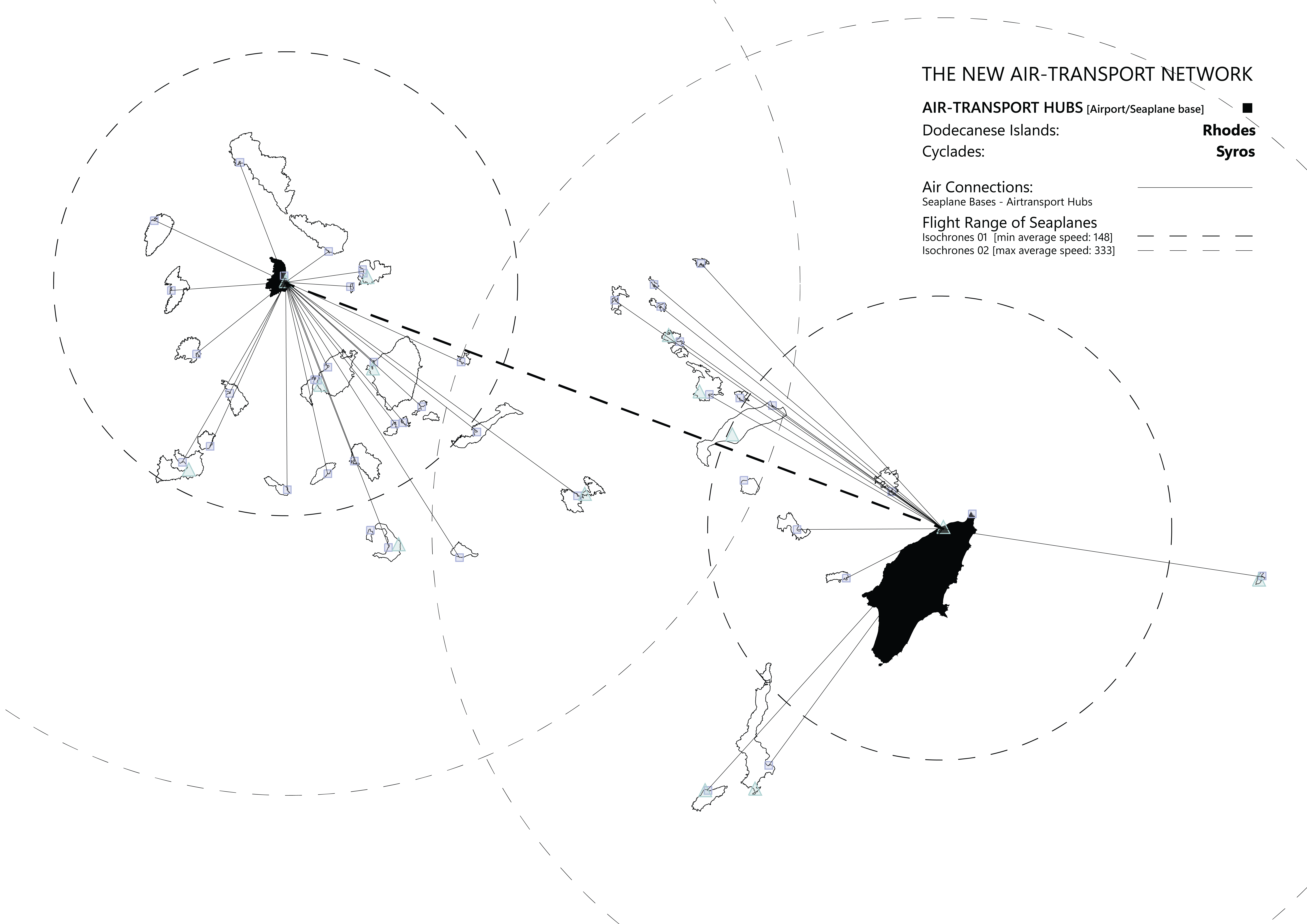
- Establishment of Key Air Transport Hubs: Based on the analysis and filtering of parameters to achieve optimal connectivity in the South Aegean Archipelago, Diagoras Airport in Rhodes Island and Syros National Airport in Syros Island have been identified as the primary air transport hubs. These airports will not only cater to international and domestic flights within the archipelago but will also feature seaplane facilities, significantly enhancing connectivity options.
- Seaplane Connectivity to Island Clusters: Each island in the Cyclades and Dodecanese clusters will establish seaplane connections with the two main air transport hubs. Strategically located seaplane facilities within the ports of these islands will enable convenient and efficient transportation between the islands and the primary airports, ensuring seamless interconnectivity throughout the archipelago.
- Integration of Existing Port and Ferry Services: In addition to the air transport network, the archipelago will maintain its existing port and ferry connections. This comprehensive approach guarantees continuous connectivity between all the islands within the clusters and ensures accessibility to and from Athens. By combining multiple modes of transportation, including air, air-sea, and ferry, the network addresses potential gaps in air travel accessibility while providing alternative means of reaching the islands.
