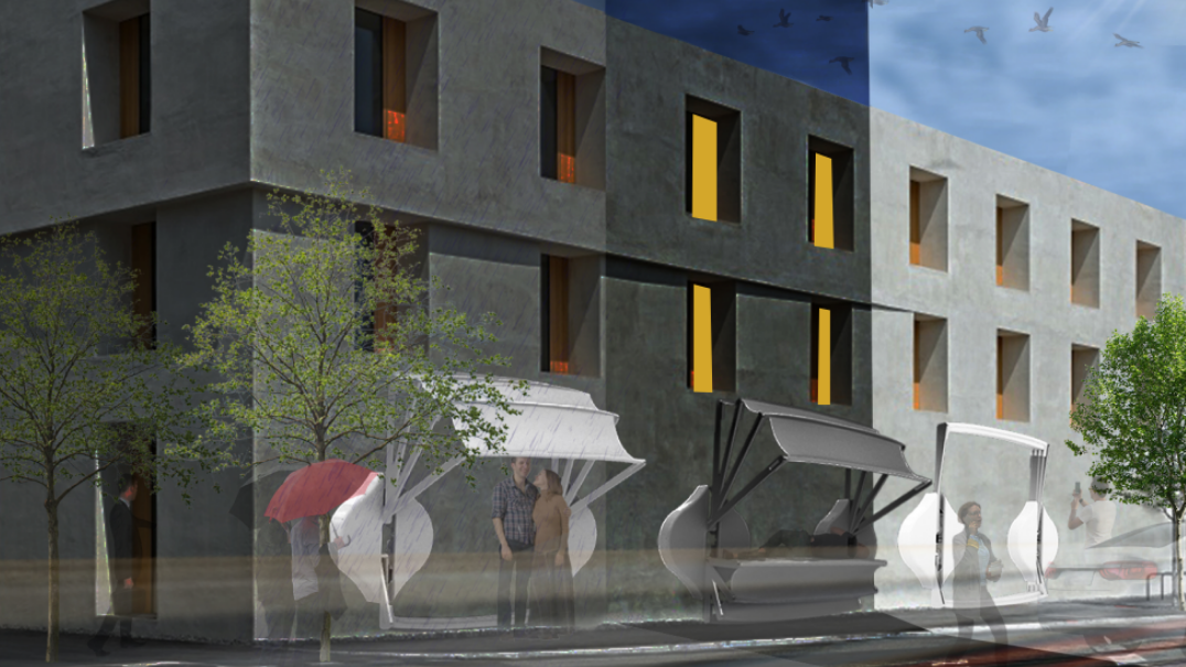
Navigating GeoPandas and the Digital Wilderness

“Start the machine” …was the first operation in mind when asked to perform a task with Python script. One of the motivations to learn Python as an urban designer is to organize geospatial data with accuracy and legibility. Before we dive into the digital wilderness, of data trees and data frames, it’s important to note … Read more

LIFECYCLE OF WOOD

Deconstruction involves the systematic dismantling of buildings to recover valuable materials such as wood, metal, glass, and concrete. This approach prioritizes the preservation of materials for reuse, recycling, or upcycling, diverting a substantial amount of waste from landfills. The extracted materials form the basis of material banks, which act as repositories for salvaged construction elements. … Read more

Slo-Mo-Go: Tourism in Slow Motion

A digital tool proposed to re-boost the economy of Ciutat Vella, Barcelona Overview Ciutat Vella being the oldest district of the city of Barcelona was founded in the 1500 BC. The Ciutat Vella district was a very important economic hub for Barcelona. But in the recent times, the district faces problems that are characterised by … Read more

La Zona Franca, Barcelona. A new centrality?

The Zona Franca in Barcelona is an area that receives thousands of workers everyday and, having The Port, is one of the main points of contact of the city with the rest of the world. Through a quick analysis based on an understanding of the site, questions and issues within Barcelona’s ‘Free-Trade’ zone are tackled … Read more

Sunlit Streets, Shaded Paths

Computational Tools for Thermally Comfortable Walks in Barcelona On one of the sunniest days in the city of Barcelona, you want to go for a walk and get some fresh air but the heat from the sun makes you uncomfortable. Can you go for the walk without the sun making you completely sick? The objective … Read more

Worldwide cityscapes spatial analysis using OpenStreetMap Data

Introduction OpenStreetMap (OSM) stands as a testament to the power of collaborative mapping, where a community of volunteers comes together to create a detailed and constantly updated geographic database. This free and open resource is not just a map; it’s a versatile tool used for everything from navigation and humanitarian aid to data visualization. OpenStreetMap … Read more

Cities in Motion

Bogota Public Transport from GTFS

The General Transit Feed Specification (GTFS) is a standardized format designed for the distribution of public transport information globally. This format facilitates the integration of public transportation systems in cities worldwide with popular route planning platforms like Citymapper, Waze, or Moovit. By doing so, it enables users to access information on transport availability and plan … Read more

Shining Rebirth

Shining Rebirth is a project about the circular lives of float glass, aluminium frame and polycarbonate roofing. Related materials are taken from IAAC atelier, with numbers, dimensions and conditions properly analysed. Carbon footprint as each stage of life is calculated, with deconstruction steps properly considered. In order to propose a new life for these materials, … Read more

Navigating Inequality

Introduction Wealth disparity leads to social and economic challenges resulting in social exclusion. 21.6% of population in the EU are at risk of social exclusion. A study confirmed that 61.7% of socially excluded people tend to be segregated. Understanding the origin of the word Segregation – initially used to set sheep apart from the flock, … Read more

Routing Accessibility

Background Public transportation plays a crucial role in urban planning globally. Extensive research indicates that bus transit has become a highly favored mass mobility system. This preference stems from its cost-effective infrastructure, flexible planning, and discrete architecture that supports incremental growth. Bus transit systems exhibit lower infrastructure costs compared to rail or subway networks, making … Read more

Mumbai Soundscape

ACT 01 *end of september 2023 in bandra mumbai during ganesha charturthi, celebratory noises are all around. sounds of people, fireworks, music, animals are heard within close proximity of a popular patisserie along turner road, west of bandra in mumbai-india* *kantha bai- a 50 year old local and bitter woman, bothered by the noises from … Read more

CIRCUITO AMBIENTAL PERUS_

El objetivo del proyecto es estudiar la posibilidad de una planificación urbana con un desarrollo integrado entre el espacio construido y el espacio natural, principio del concepto de cohesión socioterritorial. Partiendo de este enfoque de investigación, la subprefectura de Perus se considera un espacio que ofrece posibilidades para desarrollar este planteamiento. Perus es una subprefectura … Read more

GRAPH MACHINE LEARNING TOWARDS ADAPTIVE CITIES: A data-driven approach to sea level rise problematics

Abstract This thesis explores experimental approaches when addressing sea level rise challenges , the impacts of land loss due to sea rise and population growth. It delves into considerations associated with innovative approaches while emphasizing the integration of urban syntax and graph machine learning. Drawing upon case studies and open data, underscoring the importance of … Read more

Superblock BCN

A Multidimensional Study of the Superilla My research starts from observing human behaviour. Often when we face a change in our lives, especially when it wasn’t planned, we feel resistance and it takes time before we accept and embrace it.  As you probably know Barcelona in the last few years lived some changes in its … Read more