
Adaptation districts towards prioritized urban interventions in cities with limited green spaces.
The case study of the metropolitan area of Athens, Greece
Athens, during the four last decades, has been extremely urbanized while changing the environment dramatically. By reclassifying open spaces and networks of urban mobility, this model aims to suggest strategies for prioritized urban interventions based on their emergency towards climate adaptation. Since this is a reproducible model, its preliminary application will be applied for the metropolitan area of Athens because of the city’s limited urban green spaces and dysfunctional urban mobility network.
The main problem:
The main problem addressed in this study are the effects of dense and randomly expanded cities related to climate change. The most frequent ones are : 1) Urban Heat Island, 2) Vulnerability to Flood Risk, 3) Air Quality Degradation
Main Urban Issues related to climate change in the city of Athens
- Urban sprawl in high density and loss of green spaces.
- High population & overcrowding
- Traffic congestion and dysfunctional urban mobility
- To a large extent the city is an unplanned (random) urban grid.
- Unsupervised and outdated infrastructure ( energy, waste management) .
Effects related to climate change in the city of Athens:
- Increased temperatures
- Urban heat island
- Heat waves
- Long periods of droughts causing desertification
- Air Quality Degradation
- Vulnerability to extreme weather conditions..
While the efforts in administrative and planning level are fragmented, the city’s random morphology requires a network – based approach in order to suggest urban strategies dealing with the threats above.
Literature Review:
The literature review for this study has been developed throughout a selected bibliography of 30 scientific papers and publications related to the scope of the study, published between 2010 – 2020. The bibliometric analysis shows that the terms are organized in six main groups:
- The urban scaling which deals with human and urban networks as well as scaling and power laws.
- Network science which is related to urban innovation and complex system analysis.
- The population of an urban area and its reflections on economies of scale and productivity.
- Urban innovation through classifications and the implementation of innovation districts.
- Open spaces within urban areas and how they are related to infrastructure and ecosystem services based on their local attributes.
- Issues addressing climate change and risk assessment of cities depending on their urban morphology.
Among the six main clusters visualized in the cloud chart, this study will emphasize the last two, since they appear to be the most related to the selection of our case study area.
Hypothesis:
The hypothesis of this model is that by using computational design to prioritize open spaces within the urban fabric according to their environmental performance, could lead to more effective urban patterns and strategies for dense and randomly expanded cities.
In the context of the metropolitan area of Athens and its main urban issues related to climate change , Dimitra Founda, (Dimitra Founda et.al, 2017) reflects on the synergies between urban heat island and heat waves in Athens during the extremely hot summer of 2012. Dealing with the vulnerability of the city of Athens to extreme weather conditions. G. D. Bathrellos (G. D. Bathrellos et. al, 2015) , together with a team of Greek scientists indicate that the city of Athens is at risk of flooding from both river and flash flooding. The authors found that the most flood-prone areas in the city are located near the Ilissos and Kifissos rivers, as well as in low-lying areas with poor drainage.
In terms of strategies, Jari Niemela (Jari Niemela et. al, 2010) , together with a team of Finish scientists focuses on the use of the ecosystem services approach to improve the planning and conservation of urban green spaces in Finland such as increasing the connectivity of green spaces, promoting biodiversity, and restoring degraded areas. Yan Sun (Yan Sun, 2018) together with a team of Chinese scientists of Peking University, evaluates the potential of urban green spaces to mitigate climate change.


Methodology:
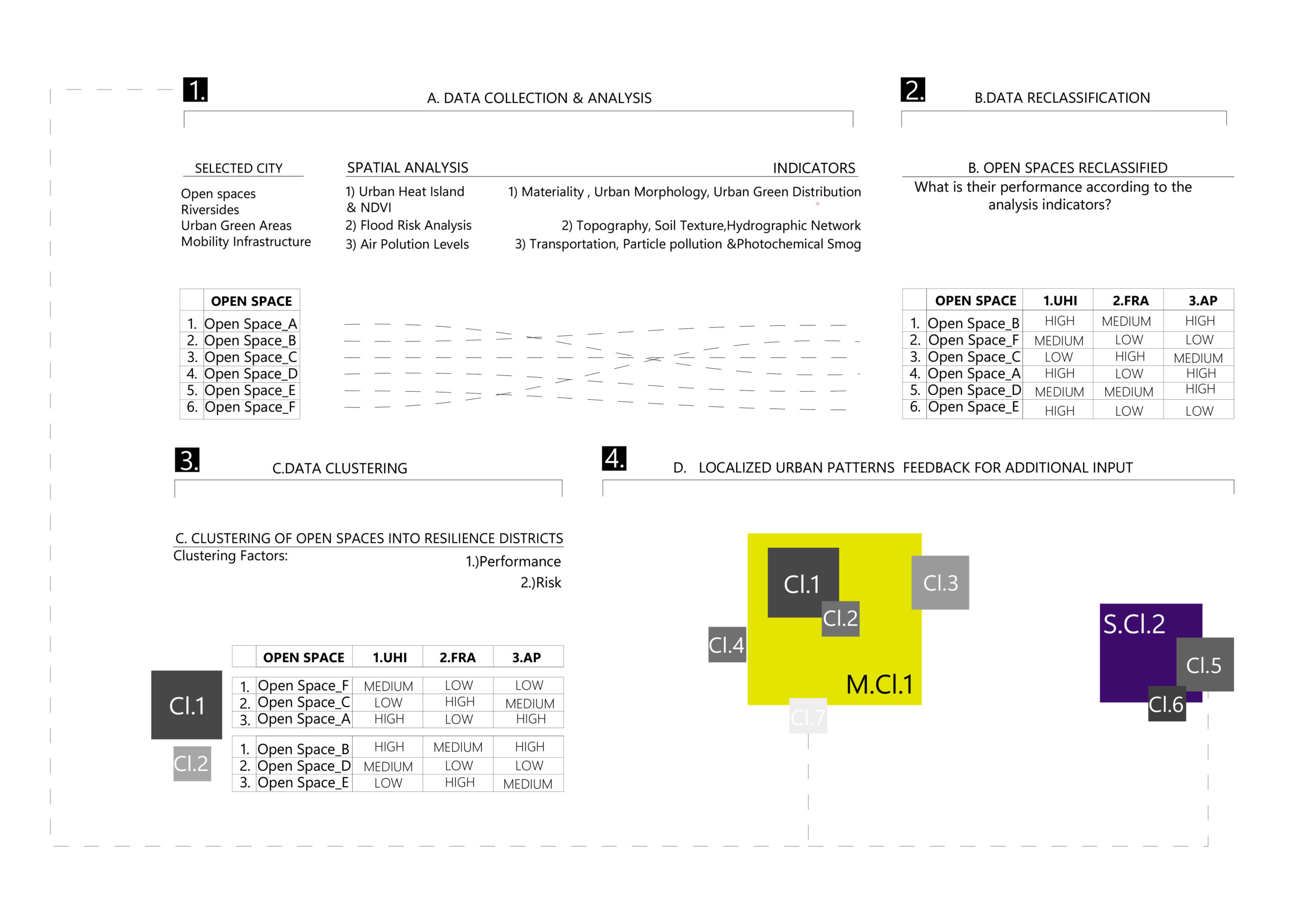
By using computational design to analyze a) urban heat island effect, b) flood risk and c) air pollution of dense cities in the Mediterranean countries this study will provide a new classification of open spaces within the urban fabric according to their ability to contribute to the city’s climate adaptation.
Such as spaces could be:
- Urban green spaces
- Urban voids
- Urban mobility network such as streets, pedestrian areas and traffic islands
The classification’s indicators defining the performance of each one of the spaces above will be based on the three main environmental issues analyzed at the first part of the analysis . Such indicators could be:
- Urban morphology, NDVI (Gorelick N. et al., 2023) and materiality for analyzing the urban heat island effect (Chakraborty, T.)
- Topography, soil texture (Hengl, 2018) and hydrographic (Lehner, B) network for analyzing the flood risk
- Particle pollution (PM) and photochemical smog (NO2, O3, CO) for air pollution ( Copernicus EMS Data and Dissemination Policy)
Following the classification, the model will make use of machine learning to provide the optimal clustering of adaptation districts indicating prioritized urban interventions and improvement based on the climate emergency and performance of the hierarchized clusters.
References:
- Founda, D., Santamouris, M., 2017. Synergies between Urban Heat Island and Heat Waves in Athens (Greece), during an extremely hot summer (2012). Sci Rep 7, 10973. https://doi.org/10.1038 /s41598-017-11407-6
- Bathrellos, G.D., Karymbalis, E., Skilodimou, H.D., Gaki-Papanastassiou, K., Baltas, E.A., 2016. Urban flood hazard assessment in the basin of Athens Metropolitan city, Greece. Environ Earth Sci 75, 319. https://doi.org/10.1007/s12665-015-5157-1
- Niemelä, J., Saarela, S.-R., Söderman, T., Kopperoinen, L., Yli-Pelkonen, V., Väre, S., Kotze, D.J., 2010. Using the ecosystem services approach for better planning and conservation of urban green spaces: a Finland case study. Biodivers Conserv 19, 3225–3243. https://doi.org/10.1007/s10531-010-9888-8
- Lehner, B., Verdin, K., Jarvis, A. (2008): New global hydrography derived from spaceborne elevation data. Eos, Transactions, AGU, 89(10): 93-94.
- Tomislav Hengl. (2018). Soil texture classes (USDA system) for 6 soil depths (0, 10, 30, 60, 100 and 200 cm) at 250 m (Version v02) [Data set]. Zenodo. 10.5281/zenodo.1475451
- Chakraborty, T., & Lee, X. (2019). A simplified urban-extent algorithm to characterize surface urban heat islands on a global scale and examine vegetation control on their spatiotemporal variability. International Journal of Applied Earth Observation and Geoinformation, 74, 269-280. doi:10.1016/j.jag.2018.09.015
- Copernicus EMS Data and Dissemination Policy, 2023
- Neri Iacopo, GitHub Page, neriiacopo, GeoMining-EE-Hops
- Gorelick, N., Hancher, M., Dixon, M., Ilyushchenko, S., Thau, D., & Moore, R. (2017). Google Earth Engine: Planetary-scale geospatial analysis for everyone.
