The Digital Tools & Big Data I course aims to introduce some key aspects of the vast world of data science and how to use them in our main objective in MaCT: understanding and designing cities.


Syllabus

Credits: MaCT01 2019/20 students Byron Cadena, Pawitra Bureerak & Akshay Marsute

From government surveys to mobile apps, from smart devices to social networks, data has been around us for all human history and its generation has skyrocketed in the past 15 years making it a vital aspect of our daily life when we are monitoring our health, we are choosing our clothes, our food, our entertainment, our representatives, our partners, our routine. There is almost not a single industry that is not using it constantly nowadays.

With this in perspective learning how to deal with data is not a matter of choice anymore. 

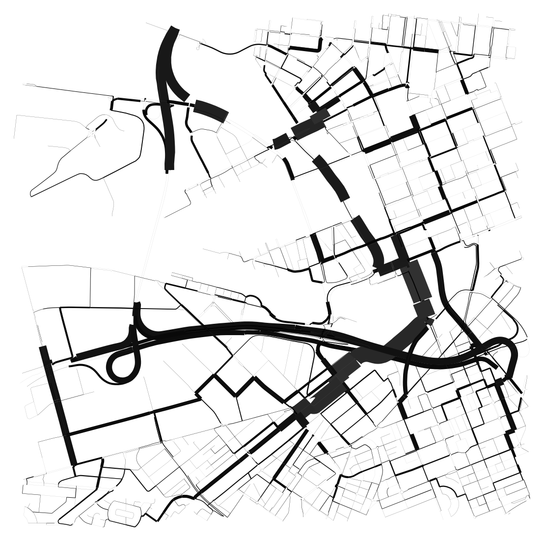
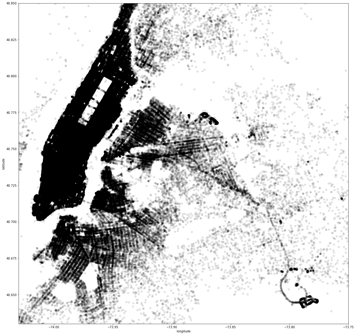
To do that we will learn some of the various types of data sources and how to deal with them, how to analyse a data set, manipulate it, visualize it and extract useful information from it using one of the most used programming languages at the moment: Python.

By the end of this course, the students will be able to enrich their projects with comprehensive data analysis and transform data into knowledge and new insights.


Faculty


Projects from this course

Melbourne Meltdown X Space Syntax

The project attempts to understand correlations between several relevant factors of today where it aims at identifying the correlations between the mental health data of the city, urban heat island effect, land surface temperature, population, green areas, total neighborhood area, green ratio per neighborhood, NDVI values, distances in 500m to the green spaces, distances in … Read more

2016 NYC Yellow Cab trip

The source dataset provided for this project is derived from the 2016 NYC Yellow Cab trip records, which were made publicly available on the Big Query platform of the Google Cloud. The data was originally collected and published by the New York City Taxi and Limousine Commission (TLC). This dataset serves as the foundation for … Read more

The Air we Breathe

An analysis of the correlation between population and air quality in the districts of Barcelona. The air quality in urban areas have rapidly declined over the years. In the process of economic development, air pollution has become a significant health hazard. This project analyses the relationship between population density and air quality levels in Barcelona. … Read more

A good worker has good taste in food!!

Some Japanese monk said “Eat well, work hard, and sleep well. This harmony is the basis of a good spirit.”From this maximum, I assumed the cities with a good work-life balance, have many delicious restaurants. Subject goal In this class, I make the graph from the open data by Pthon. Hypothesis There are many restaurants … Read more

Making walking and cycling safer

How safe is walking and cycling in Europe / Spain? In the European Union, cities and towns are home to 71 percent of the population and here is where most journeys begin and end. Urban centers face multiple, complex, and ever-evolving challenges, especially concerning mobility. Growing populations are encouraged to walk and cycle more because … Read more

Deaths from air pollution in Central Europe

Air pollution- the combination of outdoor and indoor particulate matter, and ozone– causes more than 7 million deaths each year (World Health Organisation) and it is considered to be one of the world’s largest health and environmental problems. The same data shows that 99% of the world population currently live in places with air quality … Read more

Healthcare BCN

Understanding and analysing the existing Healthcare system of Barcelona with the help of open datasets available. This further helps us to understand the robustness, need and requirement to fill the gaps in the system if any with respect to their typologies and location as per districts Step 1: Documenting the distribution of different types of … Read more

Birds and weather connectivity

This project was carried out to support research on the relationship between bird populations and natural conditions in the province of Barcelona, Catalonia. In conclusion, the most frequently observed migratory bird Cattle Egret in the province of Barcelona was identified and the rainiest time of the year is spring (month – April) when its migrating … Read more

Big Data Analytics in the Airline Industry

The case of Greece The air connections constitute critical components of the entire transportation industry in Greece. The geopolitical position of the country as well as its geographical features (mountainous landscape, islands and sea) make the air transport industry essential not only to the regional development and the growth of tourist activity, that comprises a … Read more

Correlation of real estate prices and income in USA

There are over 40,000 ZIP codes in the United States. Categorization by states and ZIP codes in order to compare data, find distinctive features and intercorrelations, and put data on map. VIsualization performed by Python, Plotly Express, Folium. In order to simplify tasks the dataset of 12 North East states is used.

Fun facts about Oscar and film industry

Every February, film lovers would be expecting where would the Oscar Awards go to. Academy Awards, known as Oscar has gone through 94 years, encouraging the workers as well as the industry developing. When we go back to the data about Oscar and the film production industry, we can find some interesting facts. I collected … Read more

Can forests still prevent floods?

Almost ten percent of Europe’s urban population is currently living in areas potentially at risk of flooding [EEA, 2022]. More than one third of the European population lives in coastal regions [EEA, 2022]. Forests play a vital role in controlling flooding by covering the soil surface from erosion due to rain, soaking up excess rainwater, … Read more